LiDAR 1m DTM Hillshade
Satellite Imagery
LiDAR 1m DTM Hillshade
Satellite Imagery
Scroll left/right to view further images.
HER: South Gloucestershire 2112 (None)
NMR: ST 78 SE 1 (205114)
SM: 1002485
NGR: ST76458438
X: 376450 Y: 184380 (OSGB36)
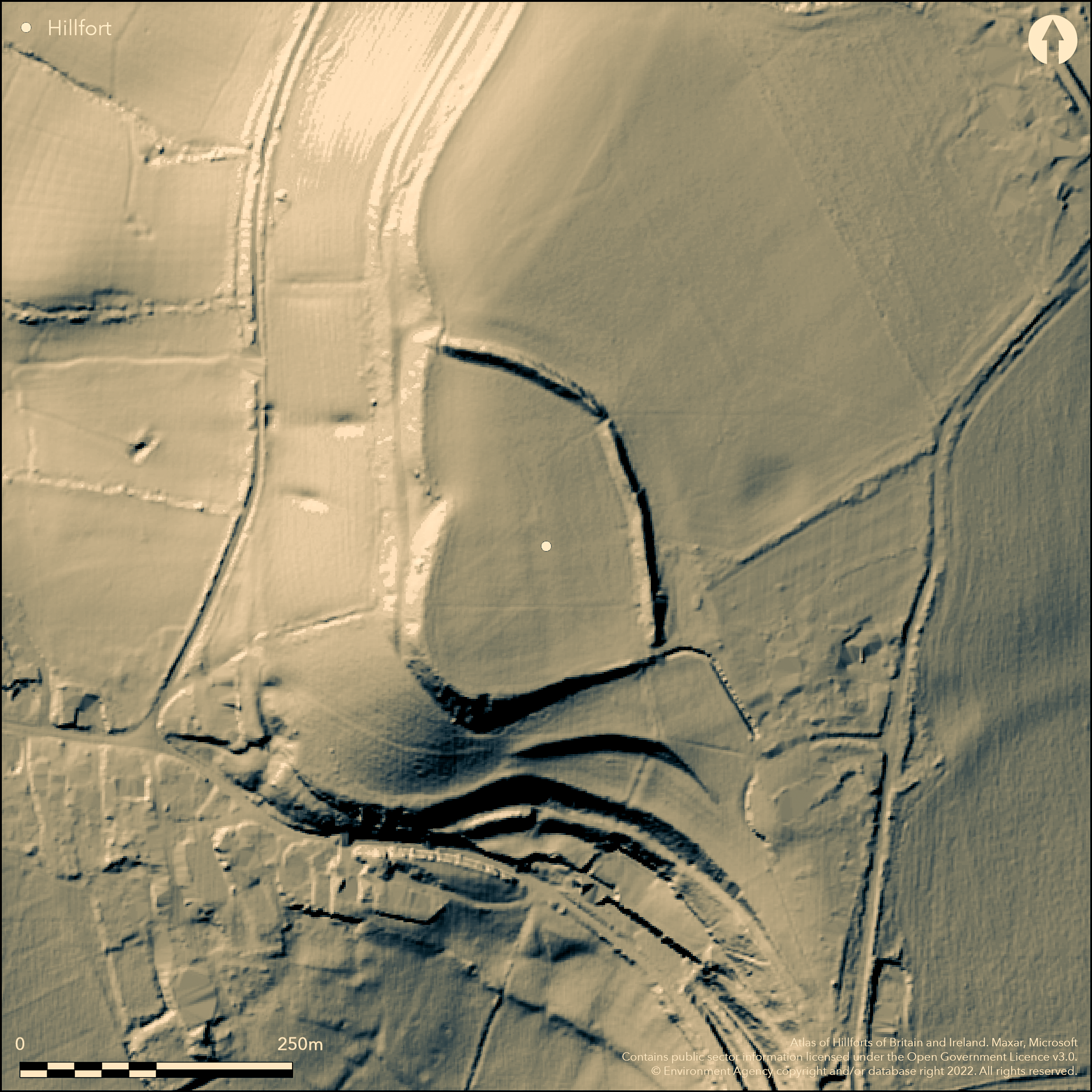
Univallate inland promontory fort located on small SW-facing spur on Cotswold edge overlooking valley of Little Avon River. Very steep surrounding slopes on S and W, moderate NE-SE. Roughly D-shaped measuring c. 203m long by 158m wide max. with flat interior c. 2.78ha. Good curvilinear rampart cuts off spur NNW-SSE, generally c. 3m high and c. 12.1 wide, with ditch to c. 7.2m wide, just traceable in part as stone-free dark ploughed soil, now buried feature and nearly gone by 1883 (Witts 1883, 27), its line determined by National Trust geophysical survey 1998. Bank fades to S after farm entrance on NE. Slight bank, to 0.6m high, runs for short distance to W from SE gap. Exposed parts of rampart show fire-reddened limestone on the outer face, midway along its length. Three entrance gaps in rampart: on N a 2m gap near W slope, on NE probably levelled for farm access and at SE corner. Original unclear, but that on SE seems favoured. Pasture interior, with trees/scrub on line of bank in SE. Tree line boundary before steep slope on W and scattered trees on S boundary. On 1st Ed. OS map (1882). Undated.
Citizen Science: ✓
Reliability of Data: Confirmed
Reliability of Interpretation: Confirmed
X: -260611 Y: 6720554 (EPSG: 3857)
Longitude: -2.3411127893494563 Latitude: 51.5577580892775 (EPSG:4326)
Country: England
Current County or Unitary Authority: South Gloucestershire
Historic County: Gloucestershire
Current Parish/Community/Council/Townland: Horton
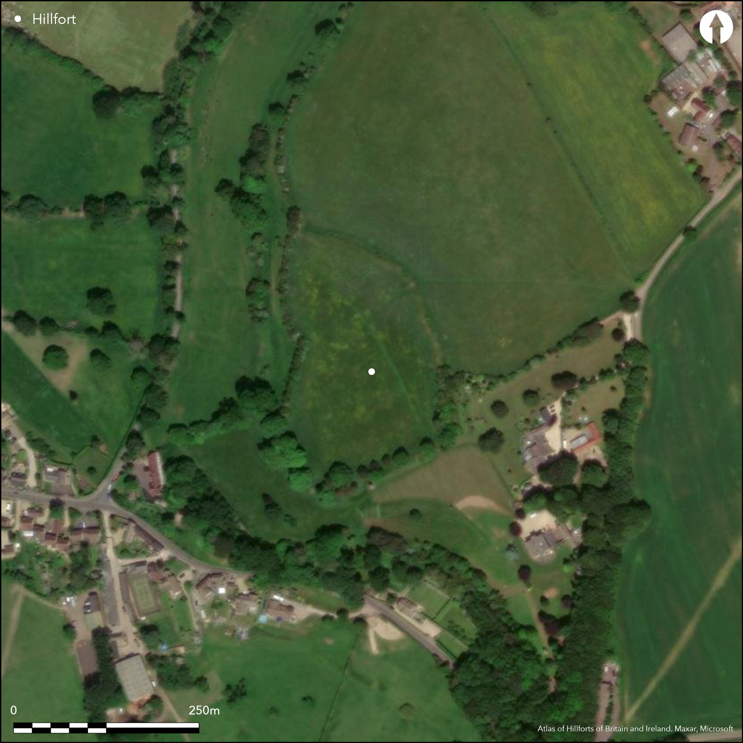
Good bank, fading from entrance S. Tractor damage in part. Ditch probably ploughed-out. Cattle grazed.
| Extant | ✓ |
| Cropmark | ✗ |
| Likely Destroyed | ✗ |
Pasture interior, with trees/scrub on line of bank in SE. Tree line boundary before steep slope on W and scattered trees on S boundary.
| Woodland | ✓ |
| Commercial Forestry Plantation | ✗ |
| Parkland | ✗ |
| Pasture (Grazing) | ✓ |
| Arable | ✗ |
| Scrub/Bracken | ✗ |
| Bare Outcrop | ✗ |
| Heather/Moorland | ✗ |
| Heath | ✗ |
| Built-up | ✗ |
| Coastal Grassland | ✗ |
| Other | ✗ |
Univallate inland promontory fort located on small SW-facing spur on Cotswold edge overlooking valley of the Little Avon River. Very steep surrounding slopes on S and W, moderate NE-SE.
| Contour Fort | ✗ |
| Partial Contour Fort | ✗ |
| Promontory Fort | ✓ |
| Hillslope Fort | ✗ |
| Level Terrain Fort | ✗ |
| Marsh Fort | ✗ |
| Multiple Enclosure Fort | ✗ |
| Hilltop | ✗ |
| Coastal Promontory | ✗ |
| Inland Promontory | ✓ |
| Valley Bottom | ✗ |
| Knoll/Hillock/Outcrop | ✗ |
| Ridge | ✗ |
| Cliff/Plateau-edge/Scarp | ✗ |
| Hillslope | ✗ |
| Lowland | ✗ |
| Spur | ✓ |
Dominant Topographic Feature: Spur promontory.
| North | ✗ |
| Northeast | ✗ |
| East | ✗ |
| Southeast | ✗ |
| South | ✗ |
| Southwest | ✗ |
| West | ✗ |
| Northwest | ✗ |
| Level | ✓ |
Altitude: 207.0m
N/A
None.
Reliability: D - None
| Pre 1200BC | ✗ |
| 1200BC - 800BC | ✗ |
| 800BC - 400BC | ✗ |
| 400BC - AD50 | ✗ |
| AD50 - AD400 | ✗ |
| AD400 - AD 800 | ✗ |
| Post AD800 | ✗ |
| Unknown | ✓ |
| Pre Hillfort: | None |
| Post Hillfort: | None |
In Aubrey's Monumenta Britannica (1665-1693). Reference by Samuel Rudder 1779. Reference by T. Baker 1821. On 1st Ed. OS map (1882). Field investigations 1962, 1977 - no details. English Heritage field visit 1984. Geophysical survey M. Papworth National Trust 1998. LiDAR survey Citizen Science information 2015.
| Other (1821): | Reference by T. Baker. |
| 1st Identified Map Depiction (1882): | OS map. |
| Other (1984): | English Heritage field visit. |
| Geophysical Survey (1998): | M. Papworth for National Trust garden investigation. |
| LiDAR Survey (2015): | Citizen Science information. |
| 1st Identified Written Reference (None): | In Aubrey's Monumenta Britannica. |
| Other (None): | Field investigations- no details. |
None.
None
| None | ✓ |
| Spring | ✗ |
| Stream | ✗ |
| Pool | ✗ |
| Flush | ✗ |
| Well | ✗ |
| Other | ✗ |
None
| No Known Features | ✓ |
| Round Stone Structures | ✗ |
| Rectangular Stone Structures | ✗ |
| Curvilinear Platforms | ✗ |
| Other Roundhouse Evidence | ✗ |
| Pits | ✗ |
| Quarry Hollows | ✗ |
| Other | ✗ |
None
| No Known Excavation | ✓ |
| Pits | ✗ |
| Postholes | ✗ |
| Roundhouses | ✗ |
| Rectangular Structures | ✗ |
| Roads/Tracks | ✗ |
| Quarry Hollows | ✗ |
| Other | ✗ |
| Nothing Found | ✗ |
None
| No Known Geophysics | ✓ |
| Pits | ✗ |
| Roundhouses | ✗ |
| Rectangular Structures | ✗ |
| Roads/Tracks | ✗ |
| Quarry Hollows | ✗ |
| Other | ✗ |
| Nothing Found | ✗ |
None
| No Known Finds | ✓ |
| Pottery | ✗ |
| Metal | ✗ |
| Metalworking | ✗ |
| Human Bones | ✗ |
| Animal Bones | ✗ |
| Lithics | ✗ |
| Environmental | ✗ |
| Other | ✗ |
None
| APs Not Checked | ✓ |
| None | ✗ |
| Roundhouses | ✗ |
| Rectangular Structures | ✗ |
| Pits | ✗ |
| Postholes | ✗ |
| Roads/Tracks | ✗ |
| Other | ✗ |
Three entrance gaps in rampart: on N a 2m gap near W slope, on NE probably levelled for farm access and at SE corner. Original unclear, but that on SE seems favoured.
| 3: | Gaps in rampart on N a 2m gap near W slope, on NE probably levelled for farm access and at SE corner |
| 2: | Possibly at SE corner. |
Guard Chambers: ✗
Chevaux de Frise: ✗
| 1. Simple Gap (South east): | Possible. |
Good curvilinear rampart cuts off spur NNW-SSE, generally c. 3m high and c. 12.1 wide, with ditch to c. 7.2m wide, just traceable in part as stone-free dark ploughed soil, now buried feature and nearly gone by 1883 (Witts 1883, 27), its line determined by National Trust geophysical survey 1998. Bank fades to S after farm entrance on NE. Slight bank, to 0.6m high, runs for short distance to W from SE gap. Exposed parts of rampart show fire-reddened limestone on the outer face, midway along its length.
| Area 1: | 2.78ha. |
| Total: | 2.78ha. |
Total Footprint Area: Noneha.
None
| ✗ | None |
| ✗ | None |
| NE Quadrant: | 1 |
| SE Quadrant: | 1 |
| SW Quadrant: | 0 |
| NW Quadrant: | 0 |
| Total: | 1 |
| Partial Univallate | ✓ |
| Univallate | ✗ |
| Partial Bivallate | ✗ |
| Bivallate | ✗ |
| Partial Multivallate | ✗ |
| Multivallate | ✗ |
| Unknown | ✗ |
| Partial Univallate | ✗ |
| Univallate | ✗ |
| Partial Bivallate | ✗ |
| Bivallate | ✗ |
| Partial Multivallate | ✗ |
| Multivallate | ✗ |
Exposed parts of rampart show fire-reddened limestone on the outer face, midway along its length.
| None | ✗ |
| Earthen Bank | ✓ |
| Stone Wall | ✗ |
| Rubble | ✗ |
| Wall-walk | ✗ |
| Evidence of Timber | ✗ |
| Vitrification | ✗ |
| Other Burning | ✓ |
| Palisade | ✗ |
| Counter Scarp Bank | ✗ |
| Berm | ✗ |
| Unfinished | ✗ |
| Other | ✗ |
None
| None | ✗ |
| Earthen Bank | ✗ |
| Stone Wall | ✗ |
| Murus Duplex | ✗ |
| Timber-framed | ✗ |
| Timber-laced | ✗ |
| Vitrification | ✗ |
| Other Burning | ✗ |
| Palisade | ✗ |
| Counter Scarp Bank | ✗ |
| Berm | ✗ |
| Unfinished | ✗ |
| No Known Excavation | ✓ |
| Other | ✗ |
| ✗ | None |
| ✓ | Ditch, to c. 7.2m wide, just traceable in part as stone-free dark ploughed soil, now buried feature and nearly gone by 1883 (Witts 1883, 27), its line determined by National Trust geophysical survey 1998. |
Number of Ditches: 1
| ✗ | None |
Anon 1999. Note, The National Trust annual archaeological review, 7/1999.
Lloyd Baker, T.J.1821. An Account of a Chain of Ancient Fortresses, extending through the South Western part of Gloucestershire, Archaeologia, 19, 161-75.
RCHME 1976. Ancient and Historical Monuments in the County of Gloucester Iron Age and Romano-British Monuments in the Gloucestershire Cotswolds, London: HMSO, 65-66.
Rudder, S. 1779. A new history of Gloucestershire, Cirencester: Samuel Rudder, 503.
Witts, G.B. 1883. Archaeological handbook of the County of Gloucester, Cheltenham: G. Norman, 27.
Atlas of Hillforts:
Wikidata:
This work is licensed under CC BY-SA 4.0![]()
![]()
![]() and should be cited as:
and should be cited as:
Lock, Gary and Ralston, Ian. 2024. Atlas of Hillforts of Britain and Ireland. Available at: https://hillforts.arch.ox.ac.uk
Document Version 1.1