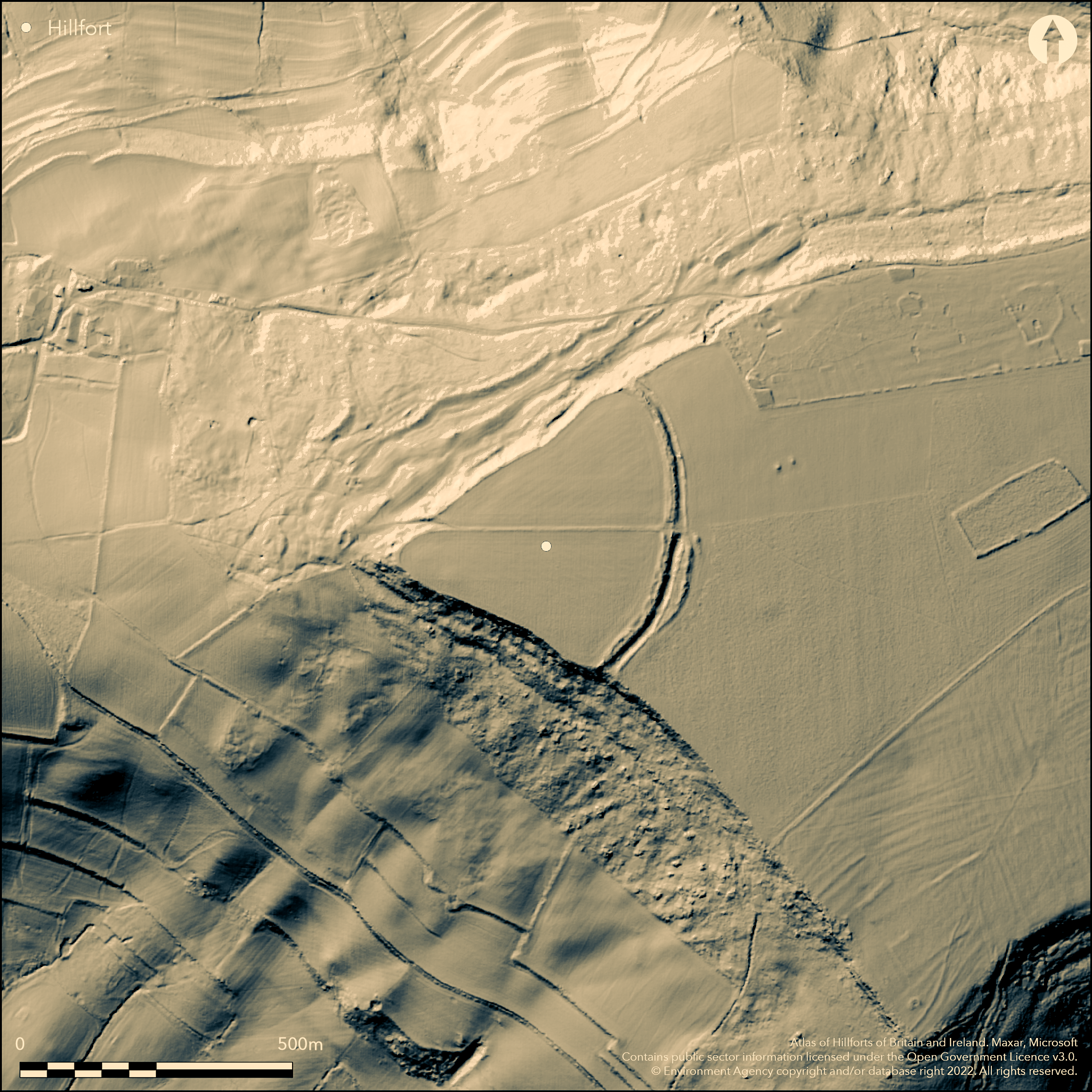
LiDAR 1m DTM Hillshade
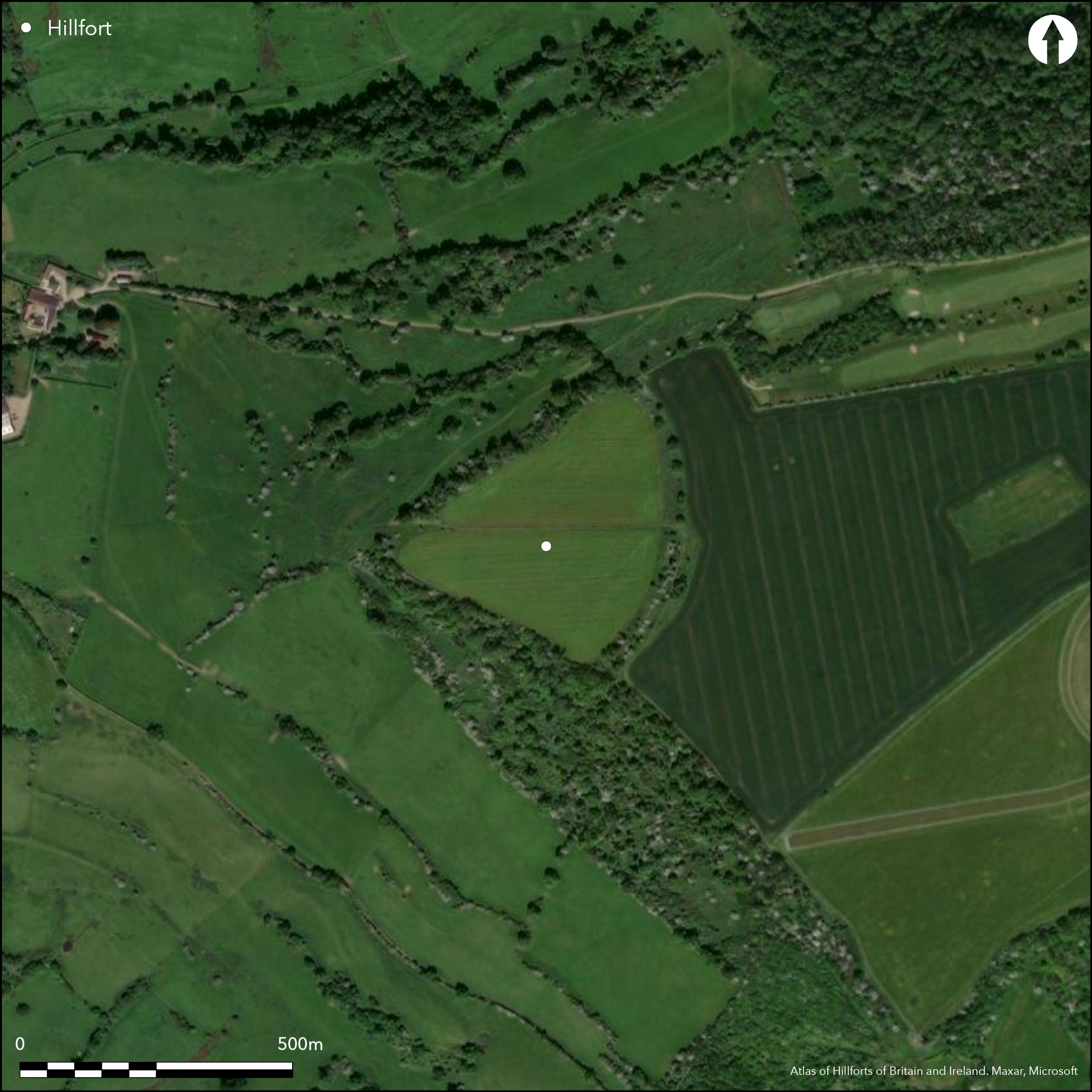
Satellite Imagery
LiDAR 1m DTM Hillshade
Satellite Imagery
Scroll left/right to view further images.
HER: Bath and NE Somerset MBN1645 (None)
NMR: ST 76 NW 16 (203710)
SM: 1004677
NGR: ST 7088 6887
X: 370885 Y: 168879 (OSGB36)
Large, presently univallate inland promontory fort located situated on summit of prominent W-projecting spur of Lansdown Hill, called Little Down, overlooking valley of River Avon. Very steep slopes down promontory on NW to SW, level to moderate NE to SE. Interior cultivated. Triangular enclosure, with interior area c. 5.5ha. Defined by N-S curving stone-faced rampart to 2m high with outer ditch to 3m deep with part counterscarp cutting off promontory on E side, the very steep slopes on N, S and W sides of promontory giving adequate definition. Irregular state of bank probably result of stone robbing. Field investigation 1966 showed ditch had three phases of completion. S of the present access entrance, mid-way down the bank, ditch 2.4m deep, with berm between it and the counterscarp bank, S of this ditch 1.7m deep, with short section of counterscarp bank and berm, becoming shallower towards the natural escapement. N of entrance ditch averages 0.8m deep with no trace of counterscarp bank, all this suggesting enclosing works never completed. Unpublished excavation by Mr Gardner of Kingswood School and F.A. Shore proved outer bank and ditch on E side, as described by G.B. Witts in 1888, but nothing now remains. Present entrance gap, providing access into interior through bank on E, could be modern and it is possible that the original entrance was out-turned at the N end of the E side. Two low rectangular mounds in interior excavated 1911 as barrows, but proved pillow mounds (Bush 1912). Additional crescent-shaped bank of to 0.5m high possible bowl barrow. Interior ploughed and cultivated. Undated. On 1st Ed. OS map (1884).
Citizen Science: ✓
Reliability of Data: Confirmed
Reliability of Interpretation: Confirmed
X: -269404 Y: 6695590 (EPSG: 3857)
Longitude: -2.4201013953638824 Latitude: 51.41812121778169 (EPSG:4326)
Country: England
Current County or Unitary Authority: Bath and NE Somerset
Historic County: Somerset
Current Parish/Community/Council/Townland: North Stoke
Path fom E-W through interior in effect divides site into two fields. On Heritage at Risk Register (2015).
| Extant | ✓ |
| Cropmark | ✗ |
| Likely Destroyed | ✗ |
Interior ploughed and cultivated.
| Woodland | ✗ |
| Commercial Forestry Plantation | ✗ |
| Parkland | ✗ |
| Pasture (Grazing) | ✗ |
| Arable | ✓ |
| Scrub/Bracken | ✗ |
| Bare Outcrop | ✗ |
| Heather/Moorland | ✗ |
| Heath | ✗ |
| Built-up | ✗ |
| Coastal Grassland | ✗ |
| Other | ✗ |
Presently univallate inland promontory fort located situated on summit of prominent W-projecting spur of Lansdown Hill, called Little Down, overlooking valley of River Avon. Very steep slopes down promontory on NW to SW, level to moderate NE to SE.
| Contour Fort | ✗ |
| Partial Contour Fort | ✗ |
| Promontory Fort | ✓ |
| Hillslope Fort | ✗ |
| Level Terrain Fort | ✗ |
| Marsh Fort | ✗ |
| Multiple Enclosure Fort | ✗ |
| Hilltop | ✗ |
| Coastal Promontory | ✗ |
| Inland Promontory | ✓ |
| Valley Bottom | ✗ |
| Knoll/Hillock/Outcrop | ✗ |
| Ridge | ✗ |
| Cliff/Plateau-edge/Scarp | ✗ |
| Hillslope | ✗ |
| Lowland | ✗ |
| Spur | ✓ |
Dominant Topographic Feature: Spur promontory
| North | ✗ |
| Northeast | ✗ |
| East | ✗ |
| Southeast | ✗ |
| South | ✗ |
| Southwest | ✗ |
| West | ✓ |
| Northwest | ✗ |
| Level | ✗ |
Altitude: 229.0m
N/A
Unknown.
Reliability: D - None
| Pre 1200BC | ✗ |
| 1200BC - 800BC | ✗ |
| 800BC - 400BC | ✗ |
| 400BC - AD50 | ✗ |
| AD50 - AD400 | ✗ |
| AD400 - AD 800 | ✗ |
| Post AD800 | ✗ |
| Unknown | ✓ |
| Pre Hillfort: | Bowl barrow in interior and outside on NW. |
| Post Hillfort: | Pillow mounds in interior and outside on SE. |
On 1st Ed. OS map (1884). Unpublished excavation by Mr Gardner of Kingswood School and F. A. Shore - no date.
| 1st Identified Map Depiction (1884): | OS map. |
| Excavation (None): | Unpublished excavation by Mr Gardner of Kingswood School and F. A. Shore. |
Two low rectangular mounds in interior excavated 1911 as barrows, but proved pillow mounds. Additional crescent-shaped bank of to 0.5m high possible bowl barrow.
None
| None | ✓ |
| Spring | ✗ |
| Stream | ✗ |
| Pool | ✗ |
| Flush | ✗ |
| Well | ✗ |
| Other | ✗ |
None
| No Known Features | ✗ |
| Round Stone Structures | ✗ |
| Rectangular Stone Structures | ✗ |
| Curvilinear Platforms | ✗ |
| Other Roundhouse Evidence | ✗ |
| Pits | ✗ |
| Quarry Hollows | ✗ |
| Other | ✓ |
Two low rectangular mounds in interior excavated 1911 as barrows, but proved pillow mounds. Additional crescent-shaped bank of to 0.5m high possible bowl barrow.
| No Known Excavation | ✗ |
| Pits | ✗ |
| Postholes | ✗ |
| Roundhouses | ✗ |
| Rectangular Structures | ✗ |
| Roads/Tracks | ✗ |
| Quarry Hollows | ✗ |
| Other | ✓ |
| Nothing Found | ✗ |
None
| No Known Geophysics | ✓ |
| Pits | ✗ |
| Roundhouses | ✗ |
| Rectangular Structures | ✗ |
| Roads/Tracks | ✗ |
| Quarry Hollows | ✗ |
| Other | ✗ |
| Nothing Found | ✗ |
None
| No Known Finds | ✓ |
| Pottery | ✗ |
| Metal | ✗ |
| Metalworking | ✗ |
| Human Bones | ✗ |
| Animal Bones | ✗ |
| Lithics | ✗ |
| Environmental | ✗ |
| Other | ✗ |
None
| APs Not Checked | ✓ |
| None | ✗ |
| Roundhouses | ✗ |
| Rectangular Structures | ✗ |
| Pits | ✗ |
| Postholes | ✗ |
| Roads/Tracks | ✗ |
| Other | ✗ |
The present entrance gap, providing access into interior through bank on E, could be modern and it is possible that the original entrance was out-turned at the N end of the E side.
| 2: | Present entrance gap, providing access into interior through bank on E, could be modern |
| 2: | Possibly at N end of E side. |
Guard Chambers: ✗
Chevaux de Frise: ✗
| 1. Out-turned (East): | Possible at N end of E side. |
Defined by N-S curving stone-faced rampart to 2m high with outer ditch to 3m deep with part counterscarp cutting off promontory on E side, the very steep slopes on N, S and W sides of promontory giving adequate defence. irregular state of bank probably result of stone robbing. Field investigation 1966 suggested ditch had three phases of completion. S of the present access entrance, mid-way down the bank, ditch 2.4m deep, with berm between it and the counterscarp bank, S of this ditch 1.7m deep, with short section of counterscarp bank and berm, becoming shallower towards the natural escapement. N of entrance ditch averages 0.8m deep with no trace of counterscarp bank, all this suggesting defences never completed. Unpublished excavation by Mr Gardner of Kingswood School and F.A. Shore proved outer bank and ditch (or outworks) on E side, as described by G.B. Witts in 1888, but nothing now remains.
| Area 1: | 5.5ha. |
| Total: | 5.5ha. |
Total Footprint Area: Noneha.
None
| ✓ | Field investigation 1966 suggested ditch had three phases of completion, but no details. |
| ✗ | Unpublished excavation by Mr Gardner of Kingswood School and F. A. Shore proved outer bank and ditch on E side, as described by G.B. Witts in 1888, but nothing now remains. |
| NE Quadrant: | 1 |
| SE Quadrant: | 1 |
| SW Quadrant: | 0 |
| NW Quadrant: | 0 |
| Total: | 1 |
| Partial Univallate | ✓ |
| Univallate | ✗ |
| Partial Bivallate | ✗ |
| Bivallate | ✗ |
| Partial Multivallate | ✗ |
| Multivallate | ✗ |
| Unknown | ✗ |
| Partial Univallate | ✗ |
| Univallate | ✗ |
| Partial Bivallate | ✗ |
| Bivallate | ✗ |
| Partial Multivallate | ✗ |
| Multivallate | ✗ |
Curving stone-faced rampart. Field investigation 1966 suggested ditch had three phases of completion. S of the present access entrance, mid-way down the bank, ditch 2.4m deep, with berm between it and the counterscarp bank, S of this ditch 1.7m deep, with short section of counterscarp bank and berm, becoming shallower towards the natural escapement. N of entrance ditch averages 0.8m deep with no trace of counterscarp bank, all this suggesting defences never completed.
| None | ✗ |
| Earthen Bank | ✗ |
| Stone Wall | ✓ |
| Rubble | ✗ |
| Wall-walk | ✗ |
| Evidence of Timber | ✗ |
| Vitrification | ✗ |
| Other Burning | ✗ |
| Palisade | ✗ |
| Counter Scarp Bank | ✓ |
| Berm | ✓ |
| Unfinished | ✓ |
| Other | ✗ |
Unpublished excavation by Mr Gardner of Kingswood School and F.A. Shore proved outer bank and ditch (or outworks) on E side, as described by G.B. Witts in 1888, but nothing now remains.
| None | ✗ |
| Earthen Bank | ✗ |
| Stone Wall | ✗ |
| Murus Duplex | ✗ |
| Timber-framed | ✗ |
| Timber-laced | ✗ |
| Vitrification | ✗ |
| Other Burning | ✗ |
| Palisade | ✗ |
| Counter Scarp Bank | ✗ |
| Berm | ✗ |
| Unfinished | ✗ |
| No Known Excavation | ✗ |
| Other | ✓ |
| ✗ | None |
| ✓ | Field investigation 1966 suggested ditch had three phases of completion. S of an entrance, mid way down the bank, ditch 2.4m deep, withcberm between it and the counterscarp bank, S of this ditch 1.7m deep, with short section of counterscarp bank and berm, becoming shallower towards the natural escapement. N of entrance ditch averages 0.8m deep with no trace of counterscarp bank, all this suggesting defences never completed. |
Number of Ditches: 1
| ✗ | None |
Burrow, E.J. 1924. The ancient earthworks and camps of Somerset, Cheltenham: E.J. Burrow, 60-1.
Burrow, I. 1981. Hillfort and hill-top settlement in Somerset in the first to eighth centuries AD, British Archaeological Report (BAR) British Series 1, 91, 234.
Bush, T. 1912. Report on Lansdown explorations and discoveries in Bath and vicinity, 1911, Somerset Arch Natur Hist , 125-6.
Page, W. ed. 1911. Ancient earthworks, The Victoria History of Somerset, Volume Two, The Victoria History of the Counties of England, London: Constable and Co, 480.
Witts, G.B. 1888. Archaeological handbook of the County of Gloucester, Cheltenham: G. Norman, 30
Atlas of Hillforts:
Wikidata:
This work is licensed under CC BY-SA 4.0

 and should be cited as:
Lock, Gary and Ralston, Ian. 2024. Atlas of Hillforts of Britain and Ireland. Available at: https://hillforts.arch.ox.ac.uk
Document Version 1.1