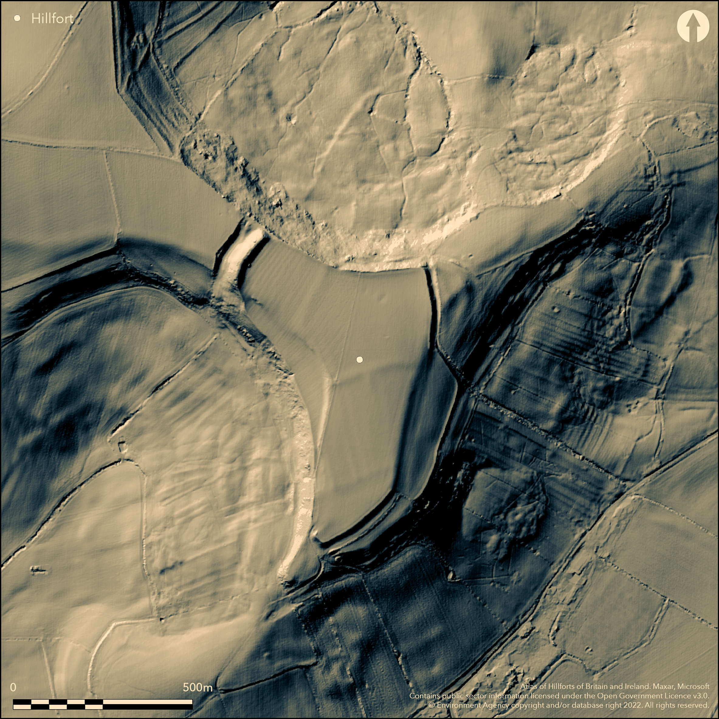
LiDAR 1m DTM Hillshade
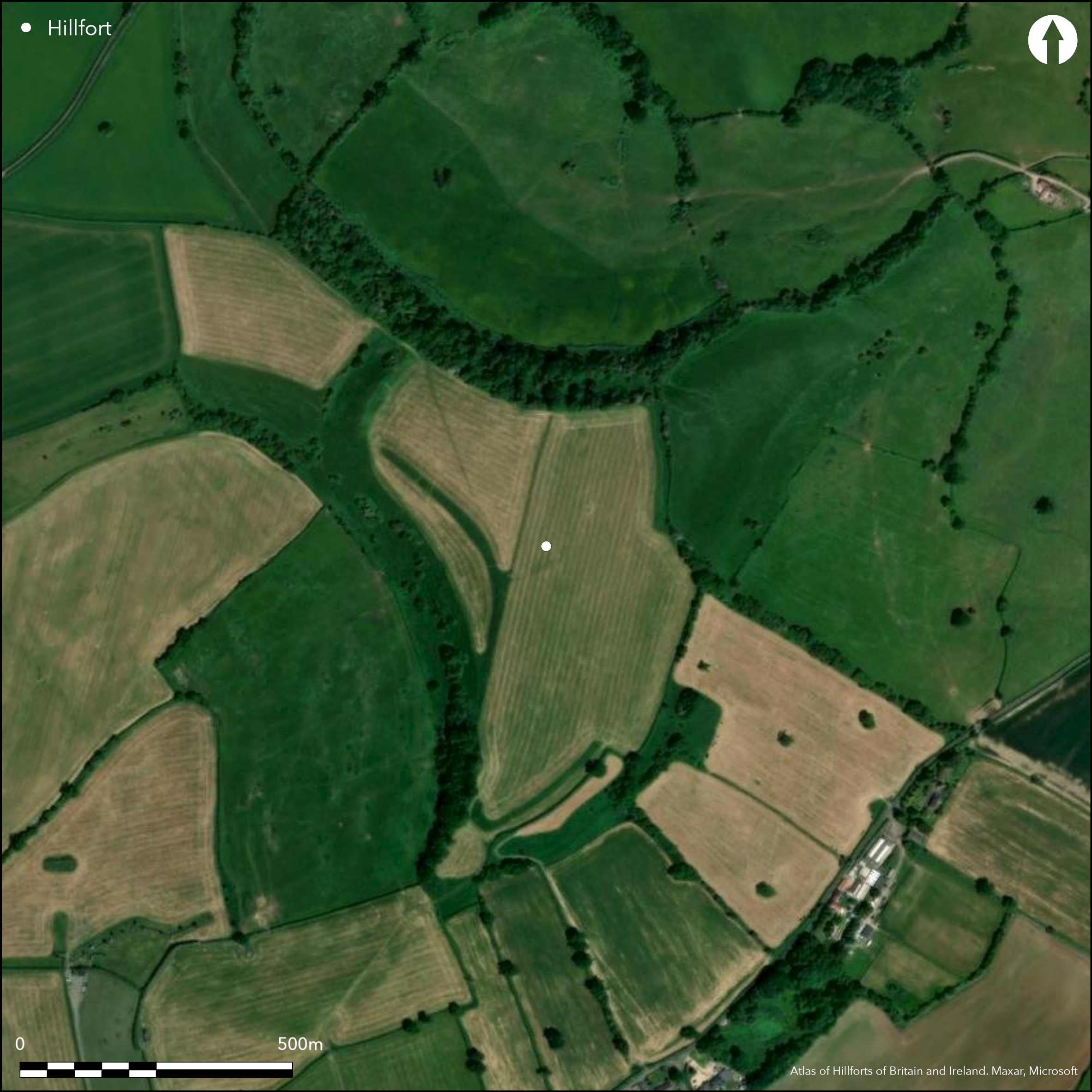
Satellite Imagery
LiDAR 1m DTM Hillshade
Satellite Imagery
Scroll left/right to view further images.
HER: Bath and NE Somerset MBN658 (None)
NMR: ST 66 NW 8 (201029)
SM: 1005424
NGR: ST60056605
X: 360050 Y: 166050 (OSGB36)
Prominent, univallate, partial contour hillfort located at S end of Dundry Hill. Steep or very steep surrounding slopes, moderate to level along ridge on NW. Semi-triangular shape, enclosing c. 10.5ha. The definition is heavily dependent on the topography, following the contours, except on far NW where massive cross-bank and ditch earthwork, some 61m long, called 'The Tump', cuts off the only accessible access to the fort from the W. This reaches c. 7.6m above the interior and as much as 15m above the ditch bottom. Considered Iron Age originally, suggestion that modified in post-Roman period to form W end of Wansdyke, Stantonbury Camp (Atlas No 3967) also being modified by the same. Elsewhere, ramparts slighter and generally depend on steepening of natural scarps, only traces remaining on N and on S single bank and rock-cut ditch ploughed down. Possible inturned SW entrance and gap between The Tump and N scarp probably original though enlarged. Two small test pits in 1958 to find dating evidence by K.J. Barton and P.A.Rahtz (1963). Geophysical survey to investigate the suggestion that Wansdyke continued into the hillfort, as part of the West Wansdyke Avon Management Study, AML Survey (Hale and Grove 1995). Iron Age pottery, two worked flints and whetstone found in plough soil at E end 1985 and early Iron Age pottery by P.A. Rahtz near NW entrance. Ploughed and grazed upland pasture. On 1st Ed. OS map (1885).
Citizen Science: ✓
Reliability of Data: Confirmed
Reliability of Interpretation: Confirmed
X: -286713 Y: 6690933 (EPSG: 3857)
Longitude: -2.575589842864484 Latitude: 51.39202276017143 (EPSG:4326)
Country: England; None
Current County or Unitary Authority: Bath and NE Somerset
Historic County: Somerset
Current Parish/Community/Council/Townland: Norton Malreward; Whitchurch
General good condition.
| Extant | ✓ |
| Cropmark | ✗ |
| Likely Destroyed | ✗ |
Ploughed and grazed upland pasture.
| Woodland | ✗ |
| Commercial Forestry Plantation | ✗ |
| Parkland | ✗ |
| Pasture (Grazing) | ✓ |
| Arable | ✗ |
| Scrub/Bracken | ✗ |
| Bare Outcrop | ✗ |
| Heather/Moorland | ✗ |
| Heath | ✗ |
| Built-up | ✗ |
| Coastal Grassland | ✗ |
| Other | ✗ |
Prominent, univallate, partial contour hillfort located at S end of Dundry Hill. Steep or very steep surrounding slopes, moderate to level along ridge on NW.
| Contour Fort | ✗ |
| Partial Contour Fort | ✓ |
| Promontory Fort | ✗ |
| Hillslope Fort | ✗ |
| Level Terrain Fort | ✗ |
| Marsh Fort | ✗ |
| Multiple Enclosure Fort | ✗ |
| Hilltop | ✓ |
| Coastal Promontory | ✗ |
| Inland Promontory | ✗ |
| Valley Bottom | ✗ |
| Knoll/Hillock/Outcrop | ✗ |
| Ridge | ✗ |
| Cliff/Plateau-edge/Scarp | ✗ |
| Hillslope | ✗ |
| Lowland | ✗ |
| Spur | ✗ |
Dominant Topographic Feature: Hill top
| North | ✗ |
| Northeast | ✗ |
| East | ✗ |
| Southeast | ✓ |
| South | ✗ |
| Southwest | ✗ |
| West | ✗ |
| Northwest | ✗ |
| Level | ✗ |
Altitude: 197.0m
Boundary Type: Parish/Townland
Early Iron Age pottery found near N entrance.
Reliability: C - Low
| Pre 1200BC | ✗ |
| 1200BC - 800BC | ✗ |
| 800BC - 400BC | ✓ |
| 400BC - AD50 | ✗ |
| AD50 - AD400 | ✗ |
| AD400 - AD 800 | ✗ |
| Post AD800 | ✗ |
| Unknown | ✗ |
| Pre Hillfort: | None |
| Post Hillfort: | None |
| Artefactual: | Early Iron Age pottery. |
In Aubrey's Monumenta Britannica (1665-1693). On 1st Ed. OS map (1885). Two small test pits to find dating evidence by K.J. Barton and P.A.Rahtz 1958. Field investigation 1962 - no details. Geophysical survey to investigate the suggestion that Wansdyke continued into the hillfort, as part of the West Wansdyke Avon Management Study, AML Survey 1995. LiDAR survey Citizen Science information 2014.
| 1st Identified Map Depiction (1885): | OS map. |
| Excavation (1958): | K.J. Barton and P.A.Rahtz. |
| Other (1962): | Field investigation - no details. |
| Other (1980): | Visit by Hillfort Study Group |
| Geophysical Survey (1995): | AML |
| LiDAR Survey (2014): | Citizen Science information. |
| 1st Identified Written Reference (None): | None |
Iron Age pottery, two worked flints and a whetstone found in plough soil at the E end of the camp indicate disturbance of the Iron Age levels, 1985. Early Iron Age pottery found by P.A. Rahtz near NW entrance.
Spring c. 700m away.
| None | ✓ |
| Spring | ✗ |
| Stream | ✗ |
| Pool | ✗ |
| Flush | ✗ |
| Well | ✗ |
| Other | ✗ |
None
| No Known Features | ✓ |
| Round Stone Structures | ✗ |
| Rectangular Stone Structures | ✗ |
| Curvilinear Platforms | ✗ |
| Other Roundhouse Evidence | ✗ |
| Pits | ✗ |
| Quarry Hollows | ✗ |
| Other | ✗ |
None
| No Known Excavation | ✗ |
| Pits | ✗ |
| Postholes | ✗ |
| Roundhouses | ✗ |
| Rectangular Structures | ✗ |
| Roads/Tracks | ✗ |
| Quarry Hollows | ✗ |
| Other | ✗ |
| Nothing Found | ✓ |
Geophysical survey to investigate the suggestion that Wansdyke continued into the hillfort, as part of the West Wansdyke Avon Management Study,
| No Known Geophysics | ✗ |
| Pits | ✗ |
| Roundhouses | ✗ |
| Rectangular Structures | ✗ |
| Roads/Tracks | ✗ |
| Quarry Hollows | ✗ |
| Other | ✗ |
| Nothing Found | ✓ |
Iron Age pottery, two worked flints and a whetstone found in plough soil at the E end of the camp indicate disturbance of the Iron Age levels, 1985. Early Iron Age pottery found by P.A. Rahtz near NW entrance.
| No Known Finds | ✗ |
| Pottery | ✓ |
| Metal | ✗ |
| Metalworking | ✗ |
| Human Bones | ✗ |
| Animal Bones | ✗ |
| Lithics | ✓ |
| Environmental | ✗ |
| Other | ✗ |
None
| APs Not Checked | ✓ |
| None | ✗ |
| Roundhouses | ✗ |
| Rectangular Structures | ✗ |
| Pits | ✗ |
| Postholes | ✗ |
| Roads/Tracks | ✗ |
| Other | ✗ |
Possible inturned SW entrance and gap between The Tump and N scarp probably original though enlarged. Five breaks in ramparts in total.
| 5: | None |
| 2: | Possibly on SW and NW. |
Guard Chambers: ✗
Chevaux de Frise: ✗
| 1. In-turned (South west): | None |
| 2. Simple Gap (North west): | Enlarged. |
Defences are heavily dependent on the topography, following the contours, except on far NW where massive cross-bank and ditch earthwork, some 61m long, called 'The Tump', cuts off the only accessible access to the fort from the W. This reaches c. 7.6m above the interior and as much as 15m above the ditch bottom. Considered Iron Age originally, suggestion that modified in post-Roman period to form W end of Wansdyke, Stantonbury Camp (Atlas No 3967) also being modified by the same. Elsewhere, defences slighter and generally depend on steepening of natural scarps, only traces remaining on N, and on S single bank and rock-cut ditch ploughed down.
| Area 1: | 10.5ha. |
| Total: | 10.5ha. |
Total Footprint Area: Noneha.
None
| ✗ | None |
| ✓ | None |
| NE Quadrant: | 1 |
| SE Quadrant: | 1 |
| SW Quadrant: | 1 |
| NW Quadrant: | 1 |
| Total: | 1 |
| Partial Univallate | ✗ |
| Univallate | ✓ |
| Partial Bivallate | ✗ |
| Bivallate | ✗ |
| Partial Multivallate | ✗ |
| Multivallate | ✗ |
| Unknown | ✗ |
| Partial Univallate | ✗ |
| Univallate | ✗ |
| Partial Bivallate | ✗ |
| Bivallate | ✗ |
| Partial Multivallate | ✗ |
| Multivallate | ✗ |
None
| None | ✗ |
| Earthen Bank | ✓ |
| Stone Wall | ✗ |
| Rubble | ✗ |
| Wall-walk | ✗ |
| Evidence of Timber | ✗ |
| Vitrification | ✗ |
| Other Burning | ✗ |
| Palisade | ✗ |
| Counter Scarp Bank | ✗ |
| Berm | ✗ |
| Unfinished | ✗ |
| Other | ✗ |
None
| None | ✗ |
| Earthen Bank | ✗ |
| Stone Wall | ✗ |
| Murus Duplex | ✗ |
| Timber-framed | ✗ |
| Timber-laced | ✗ |
| Vitrification | ✗ |
| Other Burning | ✗ |
| Palisade | ✗ |
| Counter Scarp Bank | ✗ |
| Berm | ✗ |
| Unfinished | ✗ |
| No Known Excavation | ✓ |
| Other | ✗ |
| ✗ | None |
| ✓ | Massive ditch on NW affected by modern stone building on N side. Ditch rock-cut on S. |
Number of Ditches: 1
| ✗ | None |
Avon Archaeological Unit, 1995. The West Wansdyke, Avon. A Management Study (Interim Report), Avon Archaeological Unit.
Burrow, E.J. 1924. The ancient earthworks and camps of Somerset, Cheltenham: E.J. Burrow, 62-3.
Burrow, I. 1981. Hillfort and hill-top settlement in Somerset in the first to eighth centuries AD, British Archaeological Report (BAR) British Series 1, 91, 206-7.
Fox, A. and Fox, C. 1960. Wansdyke Reconsidered. Archaeol J, 115, 1-48.
Hale, D. N. and Grove, R. 1995. Geophysical Surveys along the West Wansdyke in Avon, AML unpublished report.
Page, W. ed. 1911. Ancient earthworks, The Victoria History of Somerset, Volume Two, The Victoria History of the Counties of England, London: Constable and Co, 477-9.
Rahtz, P. A. and Barton, K. J .1963. Maes knoll Camp, Dundry, Somerset. Trial Excavations 1958, Proc Univ Bristol Spelaeol Soc, 10(1), 9-11.
Tratman, E. K. 1962-3. The Iron Age defences and Wansdyke . Proc Univ Bristol Spelaeol Soc, 10(1), 11-15.
Atlas of Hillforts:
Wikidata:
This work is licensed under CC BY-SA 4.0

 and should be cited as:
Lock, Gary and Ralston, Ian. 2024. Atlas of Hillforts of Britain and Ireland. Available at: https://hillforts.arch.ox.ac.uk
Document Version 1.1