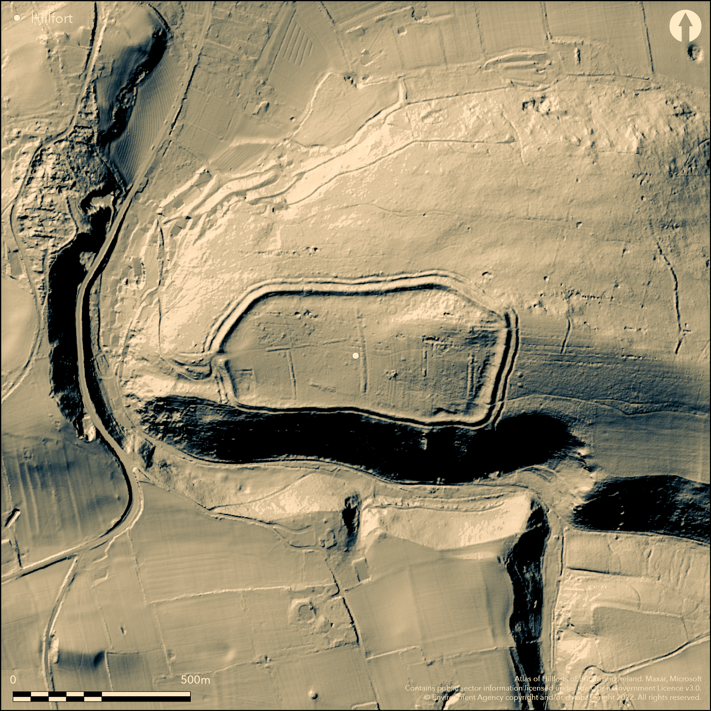
LiDAR 1m DTM Hillshade
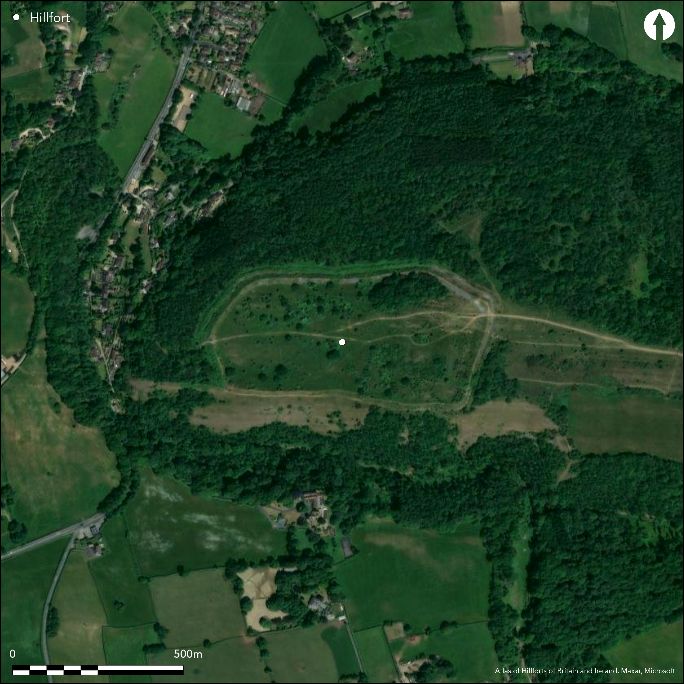
Satellite Imagery
LiDAR 1m DTM Hillshade
Satellite Imagery
Scroll left/right to view further images.
HER: North Somerset MNS251 (None)
NMR: ST 45 NE 3 (194279)
SM: 1008184
NGR: ST45005895
X: 345000 Y: 158950 (OSGB36)
Large, commanding, univallate, partial contour hillfort located on prominent E-W carboniferous limestone ridge of Dolebury Warren on NW edge of Mendip Hills and overlooking Somerset Levels. Dominates Churchill Gap leading into heart of Mendip. Steep to very steep surrounding slopes, moderate to strong along ridge to E. Sloping to W (E 60m higher than W), site interior measures 487.5m E-W by 200m, with area c. 7ha. Defined by single rampart c. 4m high and c. 12m wide, with terrace c. 5m wide on S side where scarp slope, and elsewhere by outer ditch c. 10m wide and c. 1m deep with counterscarp. Main gate at W end. Additional earthworks immediately beyond this entrance possibly later date, including hollow way linking entrance with Dolebury Bottom immediately to W. Beyond these slight linear bank c. 0.3m high and c. 1m wide with accompanying ditch c. 1.2m wide and c. 0.3m deep runs N and then W for a total of c. 550m. Possibly outwork of hillfort, maybe unfinished, which encloses area of possible contemporary use. Earthworks and depressions as outworks to NE probably small quarries and circular site in NE corner modern. Finds show long period of activity/occupation, including Palaeolithic flintwork, Bronze Age pottery, bronze spearhead and Roman coins and pottery. Post medieval pillow mounds within fort represent a rabbit warren, giving Dolebury Warren its name. Survey of site by R. and N. Hollinrake in 1980's on behalf of National Trust showed pre-medieval field system and recording of new features concerned with hillfort earthworks. Chronology for the site attempted in light of this new information. Good condition under rough pasture interior with scattered trees and scrub and tree clump on NE. S and most of E banks clear, N and W banks with scrub. Generally wooded surrounds except along ridge on E. Some small scale mining within. On 1st Ed. OS map (1885). Undated.
Citizen Science: ✓
Reliability of Data: Confirmed
Reliability of Interpretation: Confirmed
X: -310668 Y: 6679328 (EPSG: 3857)
Longitude: -2.790777853780584 Latitude: 51.32692469622203 (EPSG:4326)
Country: England; None
Current County or Unitary Authority: North Somerset
Historic County: Somerset
Current Parish/Community/Council/Townland: Churchill; Shipham
Good condition. Some small scale mining within.
| Extant | ✓ |
| Cropmark | ✗ |
| Likely Destroyed | ✗ |
Rough pasture interior with scattered trees and scrub and tree clump on NE. S and most of E banks clear, N and W banks with scrub. Generally wooded surrounds except along ridge on E. SSSI.
| Woodland | ✓ |
| Commercial Forestry Plantation | ✗ |
| Parkland | ✗ |
| Pasture (Grazing) | ✓ |
| Arable | ✗ |
| Scrub/Bracken | ✓ |
| Bare Outcrop | ✗ |
| Heather/Moorland | ✗ |
| Heath | ✗ |
| Built-up | ✗ |
| Coastal Grassland | ✗ |
| Other | ✗ |
Large, mulitivallate, commanding, partial contour hillfort located on prominent E-W carboniferous limestone ridge of Dolebury Warren on NW edge of Mendip Hills and overlooking Somerset Levels. Dominates Churchill Gap leading into heart of Mendip. Steep to very steep surrounding slopes, moderate to strong along ridge to E.
| Contour Fort | ✗ |
| Partial Contour Fort | ✓ |
| Promontory Fort | ✗ |
| Hillslope Fort | ✗ |
| Level Terrain Fort | ✗ |
| Marsh Fort | ✗ |
| Multiple Enclosure Fort | ✗ |
| Hilltop | ✗ |
| Coastal Promontory | ✗ |
| Inland Promontory | ✗ |
| Valley Bottom | ✗ |
| Knoll/Hillock/Outcrop | ✗ |
| Ridge | ✓ |
| Cliff/Plateau-edge/Scarp | ✗ |
| Hillslope | ✗ |
| Lowland | ✗ |
| Spur | ✗ |
Dominant Topographic Feature: Ridge
| North | ✗ |
| Northeast | ✗ |
| East | ✗ |
| Southeast | ✗ |
| South | ✗ |
| Southwest | ✗ |
| West | ✓ |
| Northwest | ✗ |
| Level | ✗ |
Altitude: 152.0m
Boundary Type: Parish/Townland
None.
Reliability: D - None
| Pre 1200BC | ✗ |
| 1200BC - 800BC | ✗ |
| 800BC - 400BC | ✗ |
| 400BC - AD50 | ✗ |
| AD50 - AD400 | ✗ |
| AD400 - AD 800 | ✗ |
| Post AD800 | ✗ |
| Unknown | ✓ |
| Pre Hillfort: | Probable. Bronze Age pottery found. |
| Post Hillfort: | Interior contains at least four medieval or post-medieval pillow mounds aligned N-S, ranging from 50m to 150m in length and 0.5m high - a rabbit warren. Roman coin. |
In Aubrey's Monumenta Britannica (1665-1693). In Collinson History of Somerset 1791. Mention in Rutter 1829. On 1st Ed. OS map (1885). Survey by R. and N. Hollinrake on behalf of Natural Trust 1985. Air Photograph Interpretation English Heritage: Mendip Hills AONB NMP 2006-09. Measured survey M. Bowden, English Heritage.
| Other (1829): | Mention in Rutter. |
| 1st Identified Map Depiction (1885): | OS map. |
| Other (1985): | Survey by R. and N. Hollinrake on behalf of Natural Trust. |
| Other (2008): | Measured survey M. Bowden, English Heritage. |
| 1st Identified Written Reference (None): | None |
| Other (None): | Air Photograph Interpretation English Heritage: Mendip Hills AONB NMP. |
Bronze Age pottery and a spearhead from ditch. Three Roman bronze coins, of Gallienus (AD 253-68), Constantius II or Gallus (AD 352-4), and Gratian (AD 367-75),found by Brian Cays in July 1983inside site.
None
| None | ✓ |
| Spring | ✗ |
| Stream | ✗ |
| Pool | ✗ |
| Flush | ✗ |
| Well | ✗ |
| Other | ✗ |
None
| No Known Features | ✓ |
| Round Stone Structures | ✗ |
| Rectangular Stone Structures | ✗ |
| Curvilinear Platforms | ✗ |
| Other Roundhouse Evidence | ✗ |
| Pits | ✗ |
| Quarry Hollows | ✗ |
| Other | ✗ |
None
| No Known Excavation | ✓ |
| Pits | ✗ |
| Postholes | ✗ |
| Roundhouses | ✗ |
| Rectangular Structures | ✗ |
| Roads/Tracks | ✗ |
| Quarry Hollows | ✗ |
| Other | ✗ |
| Nothing Found | ✗ |
None
| No Known Geophysics | ✓ |
| Pits | ✗ |
| Roundhouses | ✗ |
| Rectangular Structures | ✗ |
| Roads/Tracks | ✗ |
| Quarry Hollows | ✗ |
| Other | ✗ |
| Nothing Found | ✗ |
Bronze Age pottery and a spearhead from ditch. Three Roman bronze coins, of Gallienus (AD 253-68), Constantius II or Gallus (AD 352-4), and Gratian (AD 367-75),found by Brian Cays in July 1983inside site.
| No Known Finds | ✓ |
| Pottery | ✗ |
| Metal | ✗ |
| Metalworking | ✗ |
| Human Bones | ✗ |
| Animal Bones | ✗ |
| Lithics | ✗ |
| Environmental | ✗ |
| Other | ✗ |
None
| APs Not Checked | ✓ |
| None | ✗ |
| Roundhouses | ✗ |
| Rectangular Structures | ✗ |
| Pits | ✗ |
| Postholes | ✗ |
| Roads/Tracks | ✗ |
| Other | ✗ |
Main gate at W end. Additional earthworks immediately beyond this entrance possibly later date, including hollow way linking entrance with Dolebury Bottom immediately to W.
| 2: | Access through bank on NE probably modern. |
| 2: | None |
Guard Chambers: ✗
Chevaux de Frise: ✗
| 1. Simple Gap (West): | Main gate. |
Defined by single rampart c. 4m high and c. 12m wide, with terrace c. 5m wide on S side where scarp slope, and elsewhere by outer ditch c. 10m wide and c. 1m deep with counterscarp.
| Area 1: | 7.0ha. |
| Total: | 7.0ha. |
Total Footprint Area: Noneha.
None
| ✗ | None |
| ✓ | None |
| NE Quadrant: | 1 |
| SE Quadrant: | 1 |
| SW Quadrant: | 1 |
| NW Quadrant: | 1 |
| Total: | 1 |
| Partial Univallate | ✗ |
| Univallate | ✓ |
| Partial Bivallate | ✗ |
| Bivallate | ✗ |
| Partial Multivallate | ✗ |
| Multivallate | ✗ |
| Unknown | ✗ |
| Partial Univallate | ✗ |
| Univallate | ✗ |
| Partial Bivallate | ✗ |
| Bivallate | ✗ |
| Partial Multivallate | ✗ |
| Multivallate | ✗ |
Possibly outwork of hillfort, maybe unfinished, which encloses area of possible contemporary use.
| None | ✗ |
| Earthen Bank | ✓ |
| Stone Wall | ✗ |
| Rubble | ✗ |
| Wall-walk | ✗ |
| Evidence of Timber | ✗ |
| Vitrification | ✗ |
| Other Burning | ✗ |
| Palisade | ✗ |
| Counter Scarp Bank | ✓ |
| Berm | ✗ |
| Unfinished | ✓ |
| Other | ✗ |
None
| None | ✗ |
| Earthen Bank | ✗ |
| Stone Wall | ✗ |
| Murus Duplex | ✗ |
| Timber-framed | ✗ |
| Timber-laced | ✗ |
| Vitrification | ✗ |
| Other Burning | ✗ |
| Palisade | ✗ |
| Counter Scarp Bank | ✗ |
| Berm | ✗ |
| Unfinished | ✗ |
| No Known Excavation | ✓ |
| Other | ✗ |
| ✗ | None |
| ✓ | None |
Number of Ditches: 1
| ✗ | None |
Burrow, E. 1924. Ancient earthworks and camps of Somerset, Cheltenham: E.J. Burrow, 82-3.
Burrow, I. 1981. Hillfort and hill-top settlement in Somerset in the first to eighth centuries AD, British Archaeological Report (BAR) British Series 1, 208-9.
Collinson, History of Somerset, 3 1791, 579.
Dobson, D.P. 1931. Archaeology of Somerset, 196-7, 238.
Dymond, C.W. 1882. Dolebury and Cadbury: two Somersetshire camps, Brit Archaeol Ass, 38, 398-419.
Dymond, C.W. 1883, Dolbury and Cadbury: two Somersetshire camps, Somerset Arch Natur Hist, 29. 104-116.
Grinsell, L.V. 1958. Archaeology of Wessex, London: Methuen,165.
Hollinrake, R. and Hollinrake, N. 1986, Survey of Dolebury Hillfort and Dolebury Warren, Bristol Avon Archaeol, 5, 5-ll.
Knight, F.A. 1915. Heart of Mendip, 199-208.
Page, W. ed. 1911. Ancient earthworks, The Victoria History of Somerset, Volume Two, The Victoria History of the Counties of England, London: Constable and Co, 487-90.
Rutter, 1829. Delin. of North-West Somerset, 114.
Atlas of Hillforts:
Wikidata:
This work is licensed under CC BY-SA 4.0

 and should be cited as:
Lock, Gary and Ralston, Ian. 2024. Atlas of Hillforts of Britain and Ireland. Available at: https://hillforts.arch.ox.ac.uk
Document Version 1.1