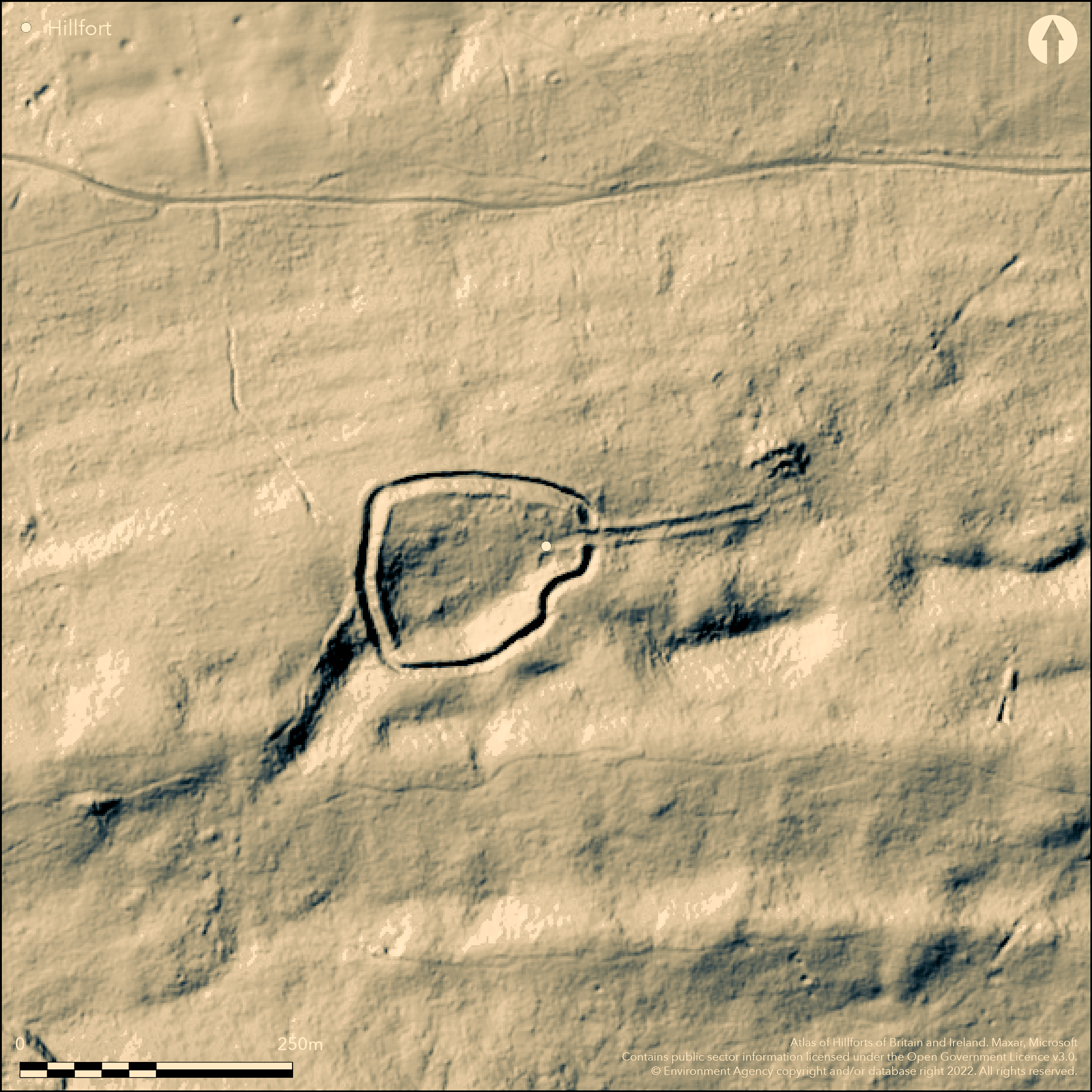
LiDAR 1m DTM Hillshade
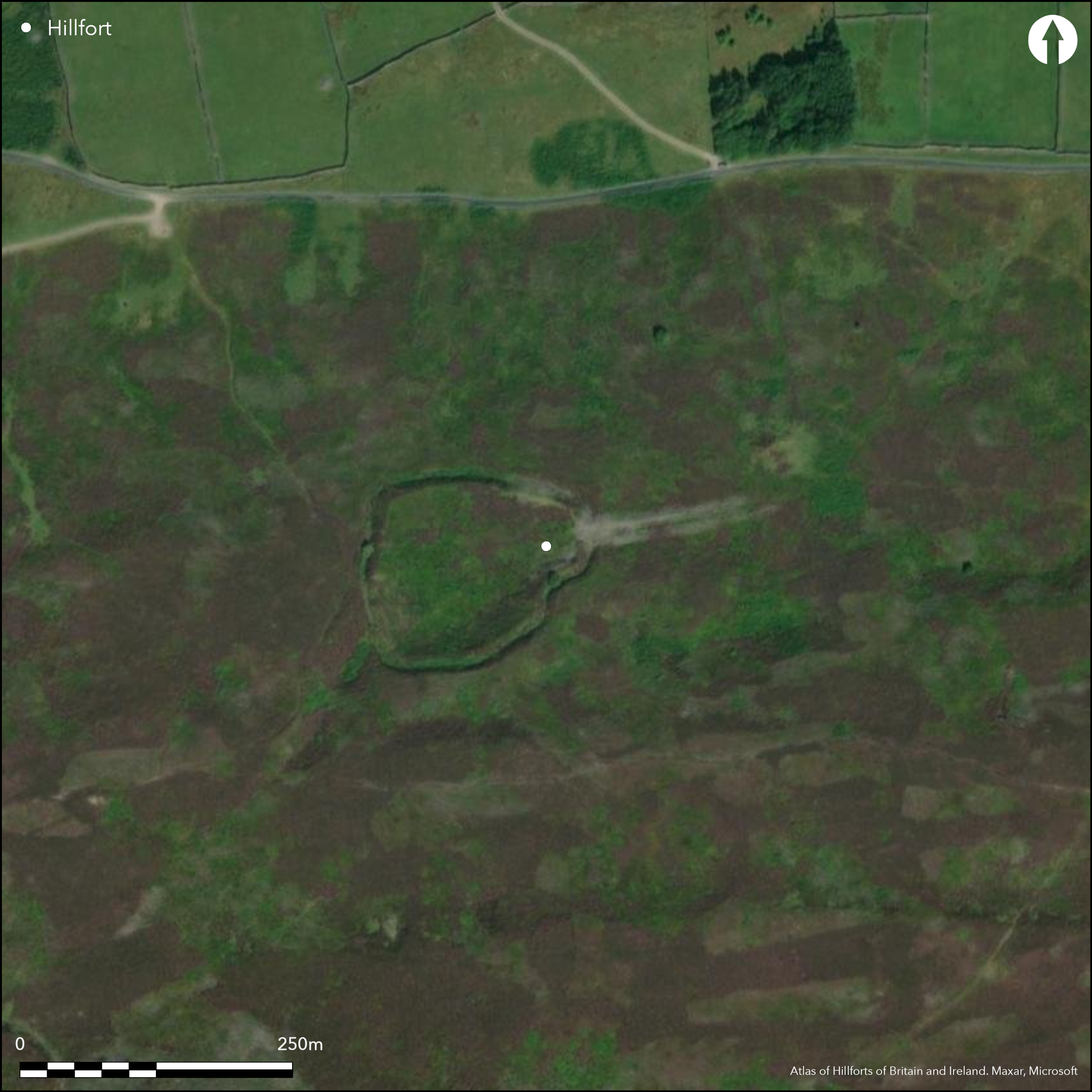
Satellite Imagery
LiDAR 1m DTM Hillshade
Satellite Imagery
Scroll left/right to view further images.
HER: North Yorkshire No record found (None)
NMR: SE 09 NW 4 (None)
SM: 1012609
NGR: SE 0222 9809
X: 402224 Y: 498096 (OSGB36)
On the N-facing slope of High Harker Hill, overlooking the confluence of the River Swale and Browna Gill, a defended enclosure or possibly a hillfort. The enclosure is sub-oval in form measuring 108m E-W by 88m N-S, enclosing 0.8ha. It comprises a substantial outer ditch with counterscarp and an inner bank on which stands the footings of a rubble rampart wall with a coursed dry stone facing. The ditch is generally 2.0-2.5m deep but increases up to 4m deep in places. Fallen stone lies all around the rampart with the greatest quantity towards the E. Large corner and facing stones form a 5m-wide entrance, possibly gated, which is approached by a 6m wide and 114m long, stone-walled passageway. The passageway survives as linear mounds of stone up to 1.5m high. Structurally its construction differs from that of the enclosure and it is uncertain if the two are contemporary. A large earth and gravel round barrow measuring 35m E-W by 28m N-S and standing 1.7m high, lies at the eastern extent of the passageway. Two possible stone-founded huts have been identified within the interior and a 20m stony platform has been slightly scarped into the rampart in the SW. The site is undated and its function is uncertain. It has been described as a cattle compound or banjo enclosure and is scheduled as a defended settlement. The marked slope of the land on the S side results in the counterscarp of the ditch being 3m higher than the crest of the rampart which, it has been argued, renders the site indefensible; for these reasons it is included here only as an unconfirmed hillfort. Recorded on 1856 1:10,560 OS mapping.
Citizen Science: ✗
Reliability of Data: Confirmed
Reliability of Interpretation: Unconfirmed
X: -218995 Y: 7242143 (EPSG: 3857)
Longitude: -1.9672662912794385 Latitude: 54.37836924279473 (EPSG:4326)
Country: England
Current County or Unitary Authority: North Yorkshire
Historic County: Yorkshire
Current Parish/Community/Council/Townland: Grinton
None
| Extant | ✓ |
| Cropmark | ✗ |
| Likely Destroyed | ✗ |
None
| Woodland | ✗ |
| Commercial Forestry Plantation | ✗ |
| Parkland | ✗ |
| Pasture (Grazing) | ✗ |
| Arable | ✗ |
| Scrub/Bracken | ✗ |
| Bare Outcrop | ✗ |
| Heather/Moorland | ✓ |
| Heath | ✗ |
| Built-up | ✗ |
| Coastal Grassland | ✗ |
| Other | ✗ |
A hillslope fort lying on the N-facing slope of High Harker Hill at 309m OD
| Contour Fort | ✗ |
| Partial Contour Fort | ✗ |
| Promontory Fort | ✗ |
| Hillslope Fort | ✓ |
| Level Terrain Fort | ✗ |
| Marsh Fort | ✗ |
| Multiple Enclosure Fort | ✗ |
| Hilltop | ✗ |
| Coastal Promontory | ✗ |
| Inland Promontory | ✗ |
| Valley Bottom | ✗ |
| Knoll/Hillock/Outcrop | ✗ |
| Ridge | ✗ |
| Cliff/Plateau-edge/Scarp | ✗ |
| Hillslope | ✓ |
| Lowland | ✗ |
| Spur | ✗ |
Dominant Topographic Feature: Hillslope
| North | ✓ |
| Northeast | ✗ |
| East | ✗ |
| Southeast | ✗ |
| South | ✗ |
| Southwest | ✗ |
| West | ✗ |
| Northwest | ✗ |
| Level | ✗ |
Altitude: 309.0m
N/A
The site is undated
Reliability: D - None
| Pre 1200BC | ✗ |
| 1200BC - 800BC | ✗ |
| 800BC - 400BC | ✗ |
| 400BC - AD50 | ✗ |
| AD50 - AD400 | ✗ |
| AD400 - AD 800 | ✗ |
| Post AD800 | ✗ |
| Unknown | ✓ |
| Pre Hillfort: | Round barrow on the eastern extent of the passageway |
| Post Hillfort: | None |
General reference in Whitaker (1826). Recorded on 1856 1:10,560 OS mapping. Field investigation in 1977, surveyed by RCHME in 1996 (ref. no. 1066873). Scheduled
| 1st Identified Written Reference (1826): | None |
| 1st Identified Map Depiction (1856): | None |
| Other (1924): | Scheduled |
| Other (1977): | Field investigation |
| Earthwork Survey (1996): | None |
Two possible stone-founded huts have been identified within the interior and a 20m stony platform has been slightly scarped into the rampart in the SW.
Overlooks the confluence of the River Swale and Browna Gill,
| None | ✓ |
| Spring | ✗ |
| Stream | ✗ |
| Pool | ✗ |
| Flush | ✗ |
| Well | ✗ |
| Other | ✗ |
Platform
| No Known Features | ✗ |
| Round Stone Structures | ✓ |
| Rectangular Stone Structures | ✗ |
| Curvilinear Platforms | ✗ |
| Other Roundhouse Evidence | ✗ |
| Pits | ✗ |
| Quarry Hollows | ✗ |
| Other | ✓ |
None
| No Known Excavation | ✓ |
| Pits | ✗ |
| Postholes | ✗ |
| Roundhouses | ✗ |
| Rectangular Structures | ✗ |
| Roads/Tracks | ✗ |
| Quarry Hollows | ✗ |
| Other | ✗ |
| Nothing Found | ✗ |
None
| No Known Geophysics | ✓ |
| Pits | ✗ |
| Roundhouses | ✗ |
| Rectangular Structures | ✗ |
| Roads/Tracks | ✗ |
| Quarry Hollows | ✗ |
| Other | ✗ |
| Nothing Found | ✗ |
None
| No Known Finds | ✓ |
| Pottery | ✗ |
| Metal | ✗ |
| Metalworking | ✗ |
| Human Bones | ✗ |
| Animal Bones | ✗ |
| Lithics | ✗ |
| Environmental | ✗ |
| Other | ✗ |
None
| APs Not Checked | ✓ |
| None | ✗ |
| Roundhouses | ✗ |
| Rectangular Structures | ✗ |
| Pits | ✗ |
| Postholes | ✗ |
| Roads/Tracks | ✗ |
| Other | ✗ |
Large corner and facing stones form a 5m-wide entrance, possibly gated, which is approached by a 6m wide and 114m long, stone-walled passageway. The passageway survives as linear mounds of stone up to 1.5m high. Structurally its construction differs from that of the enclosure and it is uncertain if the two are contemporary.
| 1: | None |
| 2: | None |
Guard Chambers: ✗
Chevaux de Frise: ✗
| 1. Passage-way/Corridor (East): | Uncertain if passageway is contemporary |
Sub-oval enclosure measuring 108m E-W by 88m N-S comprising a substantial outer ditch with counterscarp and an inner bank on which stands the footings of a rubble rampart wall with a coursed dry stone facing. The ditch is generally 2.0-2.5m deep but increases up to 4m deep in places.
| Area 1: | 0.8ha. |
| Total: | 0.8ha. |
Total Footprint Area: Noneha.
None
| ✗ | Area estimated from satellite imagery |
| ✓ | None |
| NE Quadrant: | 1 |
| SE Quadrant: | 1 |
| SW Quadrant: | 1 |
| NW Quadrant: | 1 |
| Total: | 1 |
| Partial Univallate | ✗ |
| Univallate | ✓ |
| Partial Bivallate | ✗ |
| Bivallate | ✗ |
| Partial Multivallate | ✗ |
| Multivallate | ✗ |
| Unknown | ✗ |
| Partial Univallate | ✗ |
| Univallate | ✗ |
| Partial Bivallate | ✗ |
| Bivallate | ✗ |
| Partial Multivallate | ✗ |
| Multivallate | ✗ |
None
| None | ✗ |
| Earthen Bank | ✓ |
| Stone Wall | ✓ |
| Rubble | ✓ |
| Wall-walk | ✗ |
| Evidence of Timber | ✗ |
| Vitrification | ✗ |
| Other Burning | ✗ |
| Palisade | ✗ |
| Counter Scarp Bank | ✓ |
| Berm | ✗ |
| Unfinished | ✗ |
| Other | ✗ |
None
| None | ✗ |
| Earthen Bank | ✗ |
| Stone Wall | ✗ |
| Murus Duplex | ✗ |
| Timber-framed | ✗ |
| Timber-laced | ✗ |
| Vitrification | ✗ |
| Other Burning | ✗ |
| Palisade | ✗ |
| Counter Scarp Bank | ✗ |
| Berm | ✗ |
| Unfinished | ✗ |
| No Known Excavation | ✓ |
| Other | ✗ |
| ✗ | None |
| ✓ | None |
Number of Ditches: 1
| ✗ | None |
Bowden, M. 1996. Maiden Castle Swaledale Survey. RCHME. Unpublished, ref. no. 1066873.
Bowden, M. & Blood, K. 2004. Reassessment of two late prehistoric sites: Maiden Castle and Greenber Edge in White, R.F. & Wilson, P.R. (eds) (2004) Archaeology and Historic Landscapes of the Yorkshire Dales. Yorkshire Archaeological Society Occasional Paper No 2 89-97
Whitaker, T 1823 An History of Richmondshire, London
Atlas of Hillforts:
Wikidata:
This work is licensed under CC BY-SA 4.0

 and should be cited as:
Lock, Gary and Ralston, Ian. 2024. Atlas of Hillforts of Britain and Ireland. Available at: https://hillforts.arch.ox.ac.uk
Document Version 1.1