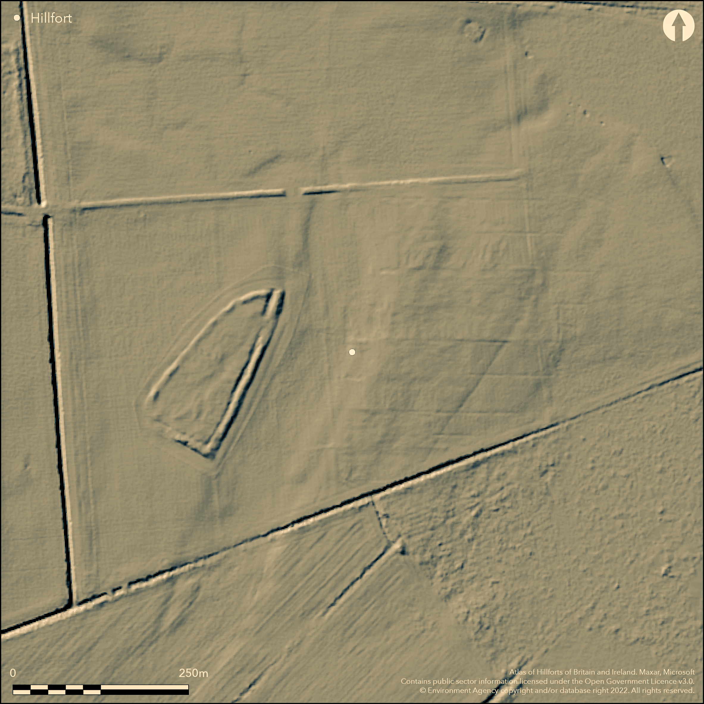
LiDAR 1m DTM Hillshade
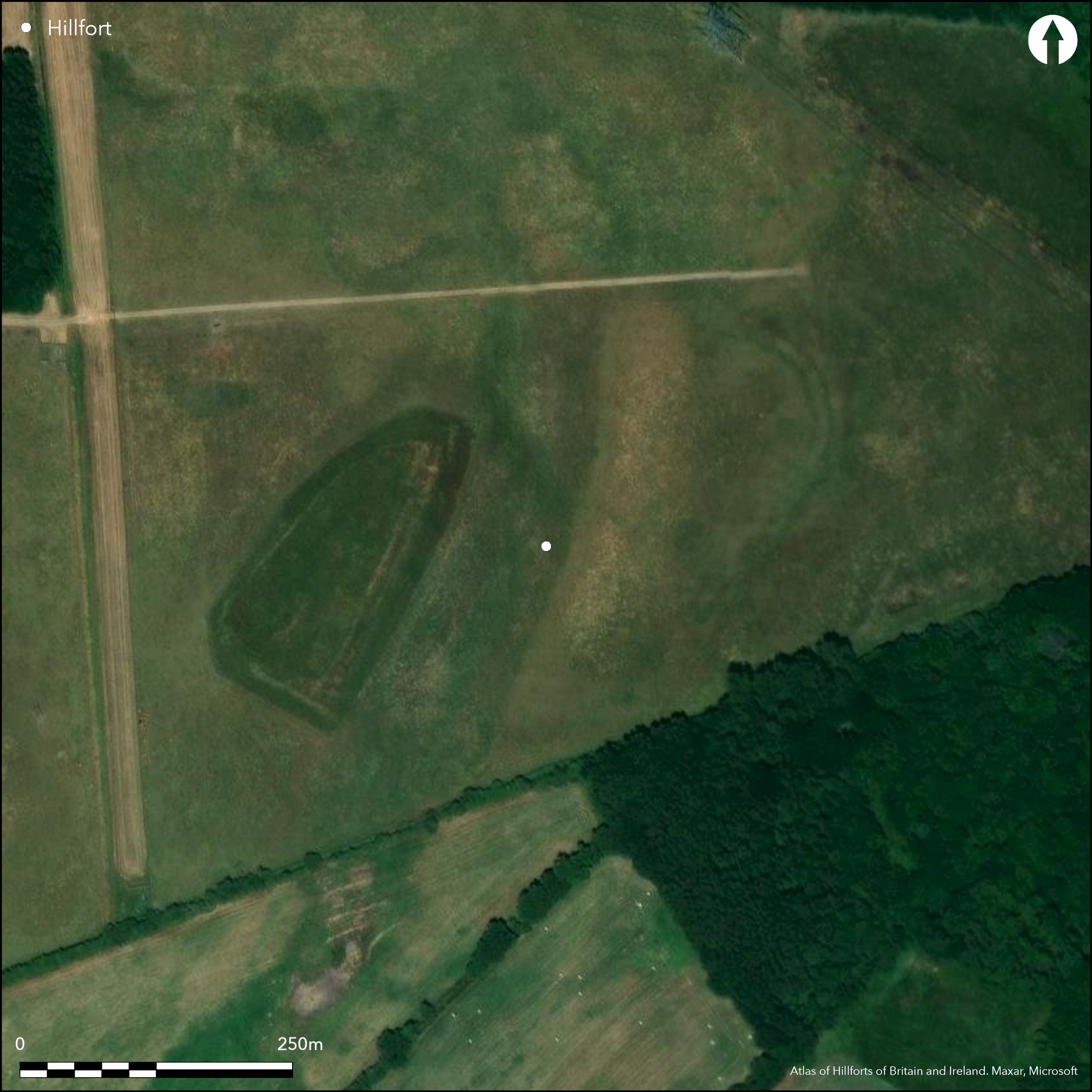
Satellite Imagery
LiDAR 1m DTM Hillshade
Satellite Imagery
Scroll left/right to view further images.
HER: South Yorkshire 00133/01 (None)
NMR: SE 51 SE 2 (56097)
SM: 1004816
NGR: SE 5639 1208
X: 456399 Y: 412082 (OSGB36)
On Sutton Common, 500m to the S of Askern, two enclosures variously described as a Roman camp (Surtees 1868), a prehistoric refuge (Whiting 1936), and an Iron Age marsh fort (Van de Noort et. al. 2007). The enclosures are sited on 'islands' on low-lying marshy ground at approximately 7m OD. The site comprises a smaller sub-triangular enclosure and larger sub-oval enclosure with opposing entrances separated by a palaeochannel of the Hampole Beck which is crossed by a post-lined, 9m wide causeway. The smaller enclosure of 0.8ha, in the W, is located at SE 56280 12055. The larger enclosure of 2.5ha, lies to the E at SE 56468 12101. It had additional earthworks in the E as defined by cropmarks of between 3 and 4 ditches and a similar number of banks. Excavation and geophysics (ibid.) has shown that the 10m wide ramparts of the larger enclosure were intermittent, formed from a timber box, filled with earth with a low limestone facing. Within the smaller enclosure, the ditch lay internally on the eastern side and externally to the outer enclosure, suggesting they might have had different functions, with the smaller enclosure an elaborate entrance way or annex into the large enclosure, with a route through the site. Areas of surrounding marshland further enhanced the isolated nature of the site. Postholes, some with partially decayed wooden stakes probably representing a palisade, appear to have been contemporary with the earthworks. A further possible palisade was also recorded. Six large oak rounded timbers defined the western gateway, which had an overall dimension of approximately 4m by 18m, with that in the E having 10 rounded timbers and maximum dimensions of 4m x 22m. Possible guard chambers were also identified. Animal bones, charcoal, two human skulls, timbers, a bone comb and a pottery sherd were recovered from the ditch terminals. In the region of 150 four-post structures were identified within the interior and considerable amounts of carbonised grain recovered from some postholes, support an interpretation that at least some were granaries. Also inside were a series of sub-circular small enclosures some with cremation burials. The purpose of a further 3000 postholes has not been elucidated. A number of possible streets including one linking the two gateways have also been identified. Dating using C14 and dendro-chronology suggest a short period of use between 372-350 BC to 350-310 BC. This dating is for the gate/ramparts not the interior structures. A possible period of abandonment was followed by the use of the site for a late Iron Age or early Roman period cemetery. The larger enclosure was plough-levelled by the 1970s and survives today as a cropmark. The enclosures are recorded on 1906 1:2,500 OS mapping. The site is scheduled as 'earthworks'.
Citizen Science: ✗
Reliability of Data: Confirmed
Reliability of Interpretation: Confirmed
X: -127926 Y: 7095188 (EPSG: 3857)
Longitude: -1.1491772589722518 Latitude: 53.60226827799718 (EPSG:4326)
Country: England; None
Current County or Unitary Authority: South Yorkshire
Historic County: Yorkshire
Current Parish/Community/Council/Townland: Norton; Owston; Burghwallis
The western enclosure is extant, the eastern enclosure is plough-levelled but survives as a cropmark
| Extant | ✓ |
| Cropmark | ✓ |
| Likely Destroyed | ✗ |
None
| Woodland | ✗ |
| Commercial Forestry Plantation | ✗ |
| Parkland | ✗ |
| Pasture (Grazing) | ✓ |
| Arable | ✗ |
| Scrub/Bracken | ✗ |
| Bare Outcrop | ✗ |
| Heather/Moorland | ✗ |
| Heath | ✗ |
| Built-up | ✗ |
| Coastal Grassland | ✗ |
| Other | ✗ |
A marsh fort lying at approximately 7m OD across two small 'islands' separated by a palaeochannel
| Contour Fort | ✗ |
| Partial Contour Fort | ✗ |
| Promontory Fort | ✗ |
| Hillslope Fort | ✗ |
| Level Terrain Fort | ✓ |
| Marsh Fort | ✓ |
| Multiple Enclosure Fort | ✗ |
| Hilltop | ✗ |
| Coastal Promontory | ✗ |
| Inland Promontory | ✗ |
| Valley Bottom | ✗ |
| Knoll/Hillock/Outcrop | ✗ |
| Ridge | ✗ |
| Cliff/Plateau-edge/Scarp | ✗ |
| Hillslope | ✗ |
| Lowland | ✓ |
| Spur | ✗ |
Dominant Topographic Feature: Drained Marsh
| North | ✗ |
| Northeast | ✗ |
| East | ✗ |
| Southeast | ✗ |
| South | ✗ |
| Southwest | ✗ |
| West | ✗ |
| Northwest | ✗ |
| Level | ✓ |
Altitude: 7.0m
Parish boundary between Norton and Owston lies to the S. Parish boundary between Norton and Burghwallis lies to the W.
Boundary Type: Parish/Townland
Eight C14 dates, six dendro-chronological dates, suggest hillfort start 372-350 BC, hillfort end 350-310 BC (Horn forthcoming). This dating is for the eastern entrance not the internal structures.
Reliability: A - High
| Pre 1200BC | ✗ |
| 1200BC - 800BC | ✗ |
| 800BC - 400BC | ✗ |
| 400BC - AD50 | ✓ |
| AD50 - AD400 | ✗ |
| AD400 - AD 800 | ✗ |
| Post AD800 | ✗ |
| Unknown | ✗ |
| Pre Hillfort: | None |
| Post Hillfort: | None |
| Artefactual: | None |
| C14: | None |
| Other: | Dendrochronological |
Described and mapped by Surtees (1868). Excavations by Whiting 1933-35, Sydes and Parker Pearson 1987-93; and Exeter and Hull Universities 1998-2003. Resistance survey over the small enclosure by the University of Sheffield in 1993 (Parker Pearson and Merrony 1993). Magnetometry across the two enclosures and the intervening relict stream channel in 2003 (Payne 2003). Field investigation in 1964. Recorded on 1906 1:2,500 OS mapping. Scheduled.
| 1st Identified Written Reference (1868): | None |
| 1st Identified Map Depiction (1906): | None |
| Other (1964): | Field investigation |
| Other (1980): | Scheduled |
| Geophysical Survey (1993): | Resistance |
| Geophysical Survey (2003): | Magnetometry |
| Excavation (None): | None |
| Excavation (None): | None |
| Excavation (None): | None |
Inside the larger enclosure approximately 150 four-post structures were identified at least some of which were possibly granaries. The purpose of a further 3000 postholes has not been elucidated. Approximately 30 small enclosures 3m by 2m some with cremated remains. A possible period of abandonment was followed by the use of the site for a late Iron Age or early Roman period cemetery.
Wooden well with brushwood floor located 2m below the surface
| None | ✗ |
| Spring | ✗ |
| Stream | ✗ |
| Pool | ✗ |
| Flush | ✗ |
| Well | ✓ |
| Other | ✗ |
None
| No Known Features | ✓ |
| Round Stone Structures | ✗ |
| Rectangular Stone Structures | ✗ |
| Curvilinear Platforms | ✗ |
| Other Roundhouse Evidence | ✗ |
| Pits | ✗ |
| Quarry Hollows | ✗ |
| Other | ✗ |
None
| No Known Excavation | ✗ |
| Pits | ✓ |
| Postholes | ✓ |
| Roundhouses | ✗ |
| Rectangular Structures | ✓ |
| Roads/Tracks | ✓ |
| Quarry Hollows | ✗ |
| Other | ✓ |
| Nothing Found | ✗ |
Little was identified by geophysics within the interior. This is possibly a reflection of what existed as the ditches of the smaller enclosure, the entrances and the palaeochannel crossed by the causeway were resolved (Payne 2003).
| No Known Geophysics | ✗ |
| Pits | ✗ |
| Roundhouses | ✗ |
| Rectangular Structures | ✗ |
| Roads/Tracks | ✗ |
| Quarry Hollows | ✗ |
| Other | ✗ |
| Nothing Found | ✓ |
Owing to the site being situated in wetland in the past the potential for the preservation of organic remains is excellent and almost 250 timber samples were taken. Wooden wheel and ladder, quernstone, comb, glass bead, lead, strip of hammered gold
| No Known Finds | ✗ |
| Pottery | ✓ |
| Metal | ✓ |
| Metalworking | ✗ |
| Human Bones | ✓ |
| Animal Bones | ✓ |
| Lithics | ✓ |
| Environmental | ✓ |
| Other | ✓ |
None
| APs Not Checked | ✓ |
| None | ✗ |
| Roundhouses | ✗ |
| Rectangular Structures | ✗ |
| Pits | ✗ |
| Postholes | ✗ |
| Roads/Tracks | ✗ |
| Other | ✗ |
Small enclosure: This is believed to be an elaborate entrance way or annex into the large enclosure with a route through the site (Van de Noort 2004). Gaps lie in the W and NE. Large enclosure: Six large oak rounded timbers defined the western gateway, which had an overall dimension of approximately 4m by 18m, with that in the E having 10 rounded timbers and dimensions of 4m x 22m. Possible guard chambers were also identified.
| 4: | Two breaks through each enclosure |
| 2: | None |
Guard Chambers: ✓
Chevaux de Frise: ✗
| 1. Simple Gap (North east): | Small Enclosure |
| 2. Simple Gap (West): | Small Enclosure |
| 3. Passage-way/Corridor (North east): | Large Enclosure - inner rampart |
| 3. Passage-way/Corridor (North east): | Large Enclosure - middle rampart |
| 3. Passage-way/Corridor (North east): | Large Enclosure - outer rampart |
| 4. Simple Gap (West): | Large enclousure |
Large sub-oval enclosure of 2.5ha now ploughed out with additional earthworks in the E as defined by cropmarks of between 3 and 4 ditches and a similar number of banks. The 10m wide ramparts were intermittent, formed from a timber box, filled with earth with a low limestone facing. External ditch. Postholes, some with partially decayed wooden stakes probably representing a palisade, appear to have been contemporary with the earthworks (Van De Noort 2004). A further possible palisade was also recorded.
| Area 1: | 2.5ha. |
| Total: | 2.5ha. |
Total Footprint Area: Noneha.
None
| ✗ | None |
| ✗ | Intermittent with up to four banks in the E |
| NE Quadrant: | 4 |
| SE Quadrant: | 1 |
| SW Quadrant: | 1 |
| NW Quadrant: | 1 |
| Total: | 4 |
| Partial Univallate | ✓ |
| Univallate | ✗ |
| Partial Bivallate | ✗ |
| Bivallate | ✗ |
| Partial Multivallate | ✓ |
| Multivallate | ✗ |
| Unknown | ✗ |
| Partial Univallate | ✗ |
| Univallate | ✗ |
| Partial Bivallate | ✗ |
| Bivallate | ✗ |
| Partial Multivallate | ✗ |
| Multivallate | ✗ |
Cropmarks
| None | ✓ |
| Earthen Bank | ✗ |
| Stone Wall | ✗ |
| Rubble | ✗ |
| Wall-walk | ✗ |
| Evidence of Timber | ✗ |
| Vitrification | ✗ |
| Other Burning | ✗ |
| Palisade | ✗ |
| Counter Scarp Bank | ✗ |
| Berm | ✗ |
| Unfinished | ✗ |
| Other | ✗ |
Description of larger enclosure
| None | ✗ |
| Earthen Bank | ✓ |
| Stone Wall | ✓ |
| Murus Duplex | ✗ |
| Timber-framed | ✓ |
| Timber-laced | ✗ |
| Vitrification | ✗ |
| Other Burning | ✗ |
| Palisade | ✓ |
| Counter Scarp Bank | ✗ |
| Berm | ✗ |
| Unfinished | ✗ |
| No Known Excavation | ✗ |
| Other | ✗ |
| ✗ | None |
| ✓ | Up to four ditches in the E |
Number of Ditches: 4
| ✓ | Uncertain. The small sub-triangular enclosure of 0.8ha separated from the larger enclosure in the E by a palaeochannel has been interpreted as possibly an elaborate entrance way or annex into the large enclosure (Van de Noort et. al. 2007). |
Horn, J. Forthcoming. The dating of hillforts in Britain and Ireland. Unpublished PhD thesis, University of Edinburgh.
Parker Pearson, M. and Sydes, R., 1997. The Iron Age enclosures and prehistoric landscape at Sutton Common, South Yorkshire PPS 63, 221-59
Parker Pearson, M. and Merrony, C. 1993. Sutton Common, Dessication Assessment 1993 - Interim Report. Sheffield Department of Archaeology and Prehistory, University of Sheffield, South Yorkshire Archaeological Services and Doncaster Museum.
Payne, 2003. Iron Age Enclosures on Sutton Common, Near Askern, South Yorkshire. Report on Geophysical Survey, June 2003. Centre for Archaeology Report 106/2003. English Heritage. https://services.english-heritage.org.uk/ResearchReportsPdfs/106-2003WEB.pdf. Accessed February 2016
Surtees, S. F. 1868. Footprints of Roman Occupation in the Southern Parts of North Humber Land. Leeds: Baines.
Van de Noort, R. 2004. Sutton Common Updated project design (including assessment report and statement of potential). v 1.2, 21 April 2004. www.projects.ex.ac.uk/suttoncommon/suttoncommon.pdf. Accessed February 2016
Van de Noort, R., Chapman, H. and Collis, J. (eds). 2007. Sutton Common: The Excavation of an Iron Age 'Marsh Fort'. CBA Research Report 154.
Whiting, C. E. 1936. Excavations on Sutton Common, 1933, 1934 and 1935. Yorkshire Archaeol J. 33, 57-80
Atlas of Hillforts:
Wikidata:
This work is licensed under CC BY-SA 4.0

 and should be cited as:
Lock, Gary and Ralston, Ian. 2024. Atlas of Hillforts of Britain and Ireland. Available at: https://hillforts.arch.ox.ac.uk
Document Version 1.1