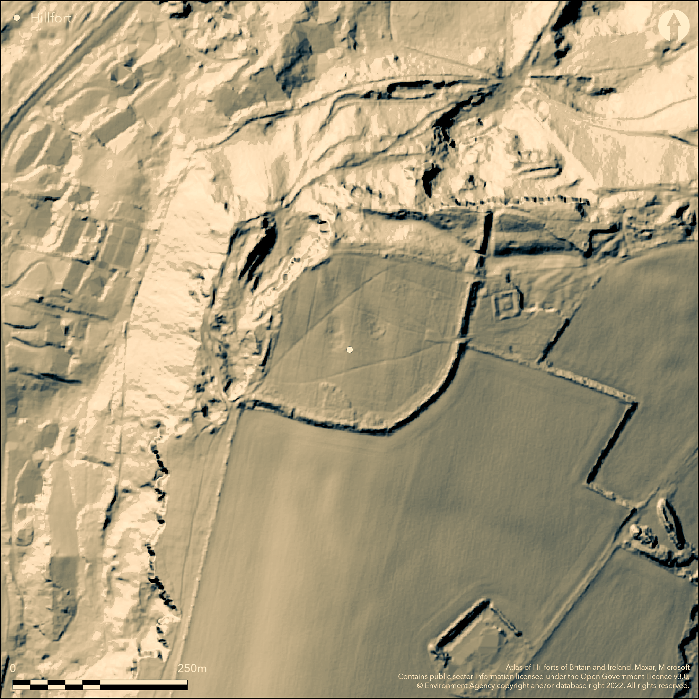
LiDAR 1m DTM Hillshade
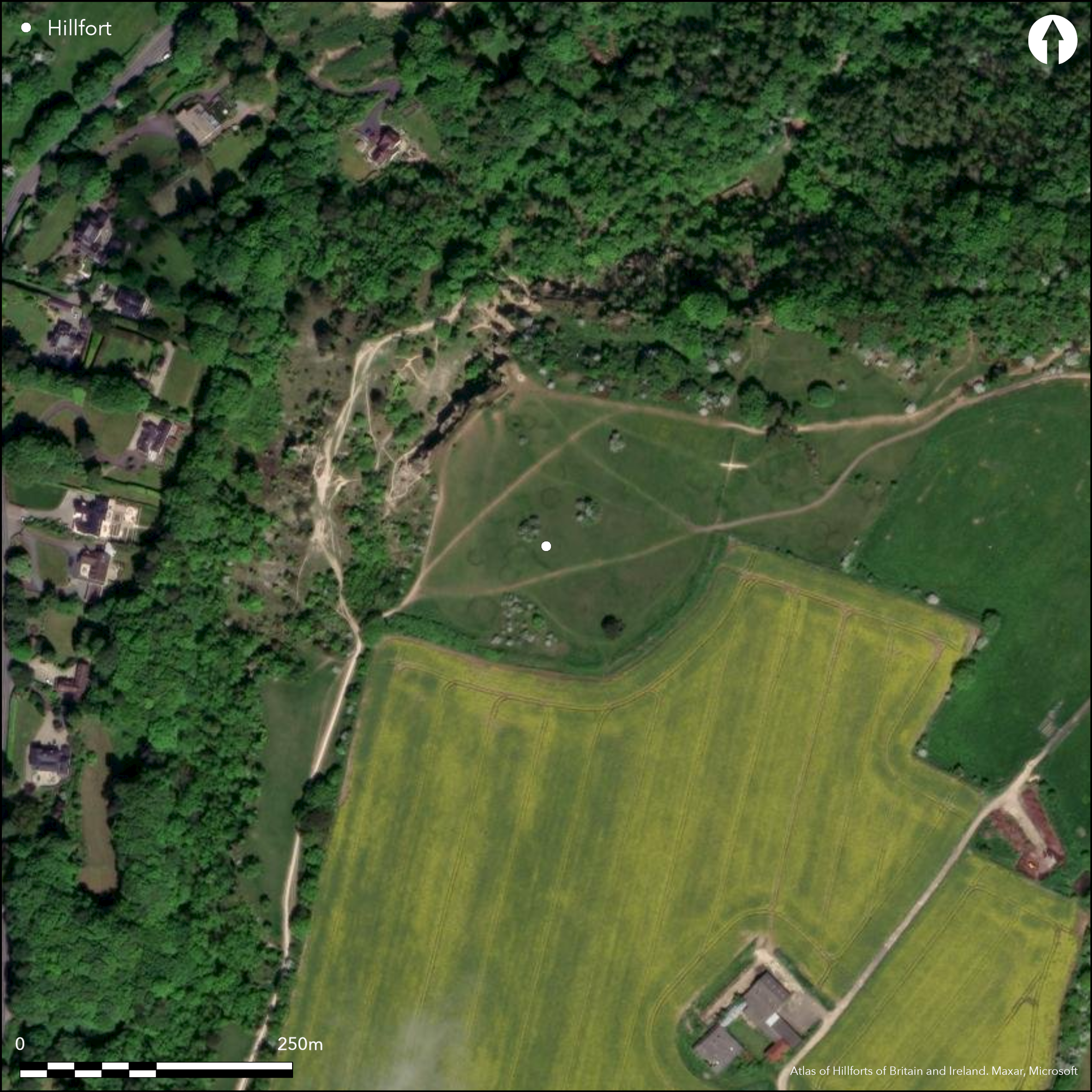
Satellite Imagery
LiDAR 1m DTM Hillshade
Satellite Imagery
Scroll left/right to view further images.
HER: Gloucestershire 171 (None)
NMR: SO 91 NW 5 (117424)
SM: 1004862
NGR: SO94781835
X: 394780 Y: 218350 (OSGB36)
Univallate, inland promontory fort located on summit of prominent NW-facing ridge of Leckhampton Hill at edge of limestone Cotswold plateau and escarpment overlooking vale and tributaries of River Chelt and Cheltenham to N and NE. Very steep to precipitous surrounding slopes on N and W, moderate to strong to S but moderate and falling along ridge to E and SE. Sub-rectangular shape, enclosing c. 2.8ha. Fort bounded on N and W by the very steep to vertical cliffs. Curving single rampart visible running from N cliffs, initially running in S direction, then curving around to W to meet the cliffs on W side. Outer ditch visible to N end of this bank, but not visible elsewhere and probably buried feature. Rock-cut in part. Possible that on W artificially enhanced scarps. Excavations by Burrow and Knowles (1925) across the E and S rampart and at the entrance were notable for the time for being thorough in both sampling and recording of levels of features and finds. This was followed by the excavations of Sara Champion 1969-71 with the immediate aim of checking the stratigraphy of rampart and ditch and re-investigating the entrance. During these studies the bank was found to be 6m wide and 1.8m high and ditch 4.2m wide and to 2.7m deep. 1925 excavators found charcoal and burnt wood in core of rampart, confirmed by Champion, with first suggestion of timber lacing in Savory's discussion published in the Dinorben report of 1964 (Champion, 1976, 181). Their suggestion of construction of stone core with soil and loose stones filling between core and a front wall disputed by Champion in view of timber-lacing. Watching Brief 2004 confirmed burnt material from bank. Complex inturned entrance on NE apex, with two stone guard chambers flanking passage and evidence of burning. Early Iron Age and Romano-British pottery from the various excavations. Much charcoal. 2008 geophysical survey found possible roundhouse evidence, possible earlier enclosure and linear boundary features in interior and later ridge and fuurrow. Pasture interior with scrub fringes. Fair condition. Wooded surrounds to N and W. Disused quarries just outside site on NE and on escarpment on W affect setting. On 1st Ed. OS map (1884-7).
Citizen Science: ✓
Reliability of Data: Confirmed
Reliability of Interpretation: Confirmed
X: -231236 Y: 6775512 (EPSG: 3857)
Longitude: -2.077226910150139 Latitude: 51.86366379103324 (EPSG:4326)
Country: England; None
Current County or Unitary Authority: Gloucestershire
Historic County: Gloucestershire
Current Parish/Community/Council/Townland: Shurdington; Coberley
Fair condition. Disused quarries just outside site on NE and on escarpment on W affect setting. Use of site as WWII radar station and area of entrance disturbed as result.
| Extant | ✓ |
| Cropmark | ✗ |
| Likely Destroyed | ✗ |
Pasture interior with scrub fringes. Wooded surrounds to N and W.
| Woodland | ✗ |
| Commercial Forestry Plantation | ✗ |
| Parkland | ✗ |
| Pasture (Grazing) | ✓ |
| Arable | ✗ |
| Scrub/Bracken | ✓ |
| Bare Outcrop | ✗ |
| Heather/Moorland | ✗ |
| Heath | ✗ |
| Built-up | ✗ |
| Coastal Grassland | ✗ |
| Other | ✗ |
Univallate, inland promontory fort fort located on summit of prominent NW-facing ridge of Leckhampton Hill at edge of limestone Cotswold plateau and escarpment overlooking vale and tributaries of River Chelt and Cheltenham to N and NE. Steep surrounding slopes on N and W, moderate to strong to S but moderate and falling along ridge to E and SE.
| Contour Fort | ✗ |
| Partial Contour Fort | ✗ |
| Promontory Fort | ✓ |
| Hillslope Fort | ✗ |
| Level Terrain Fort | ✗ |
| Marsh Fort | ✗ |
| Multiple Enclosure Fort | ✗ |
| Hilltop | ✗ |
| Coastal Promontory | ✗ |
| Inland Promontory | ✓ |
| Valley Bottom | ✗ |
| Knoll/Hillock/Outcrop | ✗ |
| Ridge | ✓ |
| Cliff/Plateau-edge/Scarp | ✗ |
| Hillslope | ✗ |
| Lowland | ✗ |
| Spur | ✗ |
Dominant Topographic Feature: Ridge
| North | ✗ |
| Northeast | ✗ |
| East | ✗ |
| Southeast | ✗ |
| South | ✗ |
| Southwest | ✗ |
| West | ✗ |
| Northwest | ✗ |
| Level | ✓ |
Altitude: 285.0m
Boundary Type: Parish/Townland
1925 excavators suggested site occupied c. 500 BC in first phase and remained occupied till after Roman Conquest, with two phases of construction. Champion's excavations suggest site of one construction period, not two and before or around fifth century BC. Chance finds also have indicated multiple phases of activity including Iron Age, Romano-British, Anglo-Saxon and medieval periods. No 'duck-stamped' pottery found, as at other Cotswold scarp sites apart from nearby Crickley Hill.
Reliability: B - Medium
| Pre 1200BC | ✗ |
| 1200BC - 800BC | ✗ |
| 800BC - 400BC | ✓ |
| 400BC - AD50 | ✓ |
| AD50 - AD400 | ✓ |
| AD400 - AD 800 | ✗ |
| Post AD800 | ✗ |
| Unknown | ✗ |
| Pre Hillfort: | None |
| Post Hillfort: | None |
| Artefactual: | Early Iron Age and Romano-British pottery. |
| Morphology/Earthwork/Typology: | Features including timber-lacing. |
On 1st Ed. OS map (1884-7). Excavation W.H. Knowles 1925. Excavation S.T. Champion 1969-71. Watching Brief D. Mullin, Gloucestershire County Council Archaeology Service 2004. LiDar survey Cranham Local History Society 2007. Geophysical survey Gloucestershire County Council detail 2008. Air Photograph Interpretation Severn Vale NMP NHPCP/Gloucestershire County Council 2013-16.
| Excavation (1925): | W.H. Knowles and others. |
| Other (1970): | Visited by Hillfort Study Group |
| Other (2002): | Leckhampton Hill and Charlton Kings Common management plan. |
| Other (2004): | Watching Brief D. Mullin, Gloucestershire County Council Archaeology Service. |
| LiDAR Survey (2007): | Cranham Local History Society. |
| Geophysical Survey (2008): | Geophysical survey Gloucestershire County Council detail. |
| 1st Identified Map Depiction (None): | OS map. |
| Excavation (None): | S.T. Champion. |
| Other (None): | Air Photograph Interpretation Severn Vale NMP NHPCP/Gloucestershire County Council. |
Magnetometer survey found shallow feature/very large hole filled with limestone on excavation. High anomaly suggested something deeper (Champion 1976, 185). 2008 geophysical survey found possible roundhouse evidence, possible earlier enclosure and linear boundary features in interior and later ridge and fuurrow.Early Iron Age and Romano-British pottery from the various excavations. Much charcoal.
Possible well in interior?
| None | ✗ |
| Spring | ✗ |
| Stream | ✗ |
| Pool | ✗ |
| Flush | ✗ |
| Well | ✓ |
| Other | ✗ |
None
| No Known Features | ✓ |
| Round Stone Structures | ✗ |
| Rectangular Stone Structures | ✗ |
| Curvilinear Platforms | ✗ |
| Other Roundhouse Evidence | ✗ |
| Pits | ✗ |
| Quarry Hollows | ✗ |
| Other | ✗ |
Magnetometer survey found shallow feature/very large hole filled with limestone on excavation (Champion 1976, 185).
| No Known Excavation | ✗ |
| Pits | ✗ |
| Postholes | ✗ |
| Roundhouses | ✗ |
| Rectangular Structures | ✗ |
| Roads/Tracks | ✗ |
| Quarry Hollows | ✗ |
| Other | ✓ |
| Nothing Found | ✗ |
Magnetometer survey found shallow feature/very large hole filled with limestone on excavation. High anomaly suggested something deeper. (Champion 1976, 185). 2008 geophysical survey found possible roundhouse evidence, possible earlier enclosure and linear boundary features in interior and later ridge and furrow.
| No Known Geophysics | ✗ |
| Pits | ✓ |
| Roundhouses | ✓ |
| Rectangular Structures | ✗ |
| Roads/Tracks | ✗ |
| Quarry Hollows | ✗ |
| Other | ✓ |
| Nothing Found | ✗ |
Early Iron Age and Romano-British pottery from the various excavations. Much charcoal.
| No Known Finds | ✗ |
| Pottery | ✓ |
| Metal | ✗ |
| Metalworking | ✗ |
| Human Bones | ✗ |
| Animal Bones | ✗ |
| Lithics | ✗ |
| Environmental | ✓ |
| Other | ✗ |
None
| APs Not Checked | ✓ |
| None | ✗ |
| Roundhouses | ✗ |
| Rectangular Structures | ✗ |
| Pits | ✗ |
| Postholes | ✗ |
| Roads/Tracks | ✗ |
| Other | ✗ |
Complex inturned entrance on NE apex, with two stone guard chambers flanking passage and evidence of burning.
| 1: | None |
| 2: | None |
Guard Chambers: ✓
Chevaux de Frise: ✗
| 1. In-turned (North east): | Complex with evidence of burning. |
| 1. Recesses/Guard Chambers (North east): | Two guard chambers flanking passage, now reassessed as paired circular stone construction in 2006. |
Curving single rampart visible running from N cliffs, initially running in S direction, then curving around to W to meet the cliffs on W side. Outer ditch visible to N end of this bank, but not visible elsewhere and probably buried feature. Possible that on W artificially enhanced scarps. During excavations bank found to be 6m wide and 1.8m high and ditch 4.2m wide and to 2.7m deep. Ditch rock-cut in part. 1925 excavators found charcoal and burnt wood in core of rampart, confirmed by Champion (1976, 183), with first suggestion of timber-lacing in Savory's discussion published in the Dinorben report of 1964 (Gardner and Savory, 1964; Champion, 1976, 181). Their suggestion of construction of stone core with soil and loose stones filling between core and a front wall suggested 1925 disputed by Champion in view of timber-lacing. Watching Brief 2004 confirmed burnt material from bank.
| Area 1: | 2.8ha. |
| Total: | 2.8ha. |
Total Footprint Area: Noneha.
None
| ✗ | 1925 excavators suggested site occupied c. 500 BC in first phase and remained occupied till after Roman Conquest, with two phases of construction. Champion's excavations suggest site of one construction period, not two. |
| ✗ | None |
| NE Quadrant: | 1 |
| SE Quadrant: | 1 |
| SW Quadrant: | None |
| NW Quadrant: | None |
| Total: | 1 |
| Partial Univallate | ✓ |
| Univallate | ✗ |
| Partial Bivallate | ✗ |
| Bivallate | ✗ |
| Partial Multivallate | ✗ |
| Multivallate | ✗ |
| Unknown | ✗ |
| Partial Univallate | ✗ |
| Univallate | ✗ |
| Partial Bivallate | ✗ |
| Bivallate | ✗ |
| Partial Multivallate | ✗ |
| Multivallate | ✗ |
None
| None | ✗ |
| Earthen Bank | ✓ |
| Stone Wall | ✗ |
| Rubble | ✗ |
| Wall-walk | ✗ |
| Evidence of Timber | ✗ |
| Vitrification | ✗ |
| Other Burning | ✗ |
| Palisade | ✗ |
| Counter Scarp Bank | ✗ |
| Berm | ✗ |
| Unfinished | ✗ |
| Other | ✗ |
During excavations bank found to be 6m wide and 1.8m high and ditch 4.2m wide and to 2.7m deep. 1925 excavators found charcoal and burnt wood in core of rampart, confirmed by Champion (1976, 183), with first suggestion of timber lacing in Savory's discussion published in the Dinorben report of 1964 (Gardner and Savory, 1964; Champion, 1976, 181). Their suggestion of construction of stone core with soil and loose stones filling between core and a front wall disputed by Champion in view of timber-lacing. Watching Brief 2004 confirmed burnt material from bank.
| None | ✗ |
| Earthen Bank | ✓ |
| Stone Wall | ✓ |
| Murus Duplex | ✗ |
| Timber-framed | ✗ |
| Timber-laced | ✓ |
| Vitrification | ✗ |
| Other Burning | ✓ |
| Palisade | ✗ |
| Counter Scarp Bank | ✗ |
| Berm | ✗ |
| Unfinished | ✗ |
| No Known Excavation | ✗ |
| Other | ✗ |
| ✗ | None |
| ✓ | Outer ditch visible to N end of this bank, but not visible elsewhere and probably buried feature. Ditch flat-bottomed and rock-cut in part. |
Number of Ditches: 1
| ✗ | None |
Burrow, E.J. and Knowles, K. 1925. Excavations on Leckhampton Hill, Cheltenham, Trans Bristol Gloucestershire Archaeol Soc, 47, 81-112.
Champion, S. 1971. Excavations at Leckhampton Hill, 1969-70 Interim Report, Trans Bristol Gloucestershire Archaeol Soc, 112, 59-72.
Champion, S. 1976. Leckhampton Hill, Gloucestershire 1925 and 1970, In ed D.W. Harding, Hillforts : later prehistoric earthworks in Britain and Ireland, 177-92.
Darvill, T. 2011. Prehistoric Gloucestershire. Forests and vales and high blue hills, 2nd Edition, Stroud: Amberley Publishing.
Kilminster, G. 1996. Gloucestershire unpublished excavations list, Glevensis, 29, 38.
Mullin, D. 2004. Archaeological Recording at Leckhampton Camp, Leckhampton, Gloucestershire, unpublished report Gloucestershire County Council Archaeology Service.
Atlas of Hillforts:
Wikidata:
This work is licensed under CC BY-SA 4.0

 and should be cited as:
Lock, Gary and Ralston, Ian. 2024. Atlas of Hillforts of Britain and Ireland. Available at: https://hillforts.arch.ox.ac.uk
Document Version 1.1