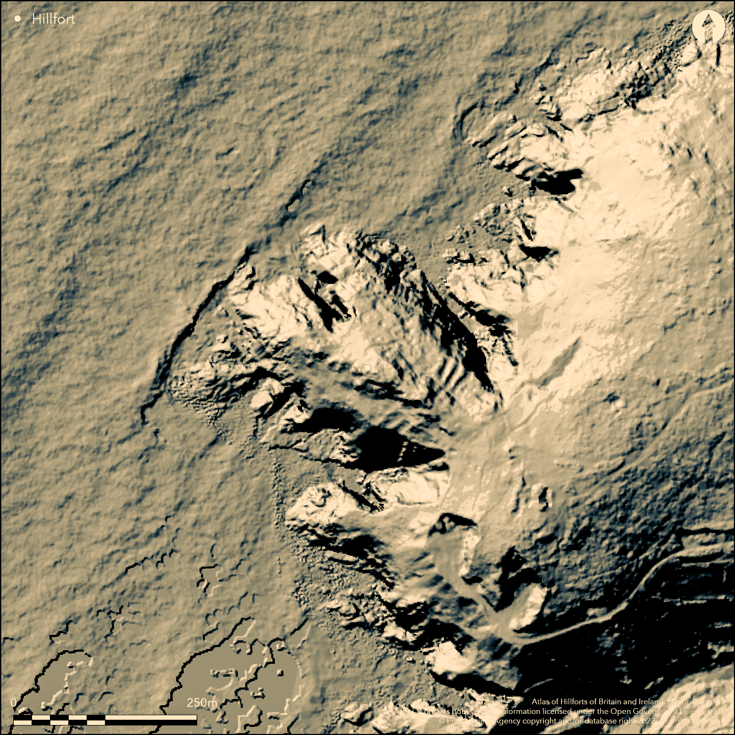
LiDAR 1m DTM Hillshade
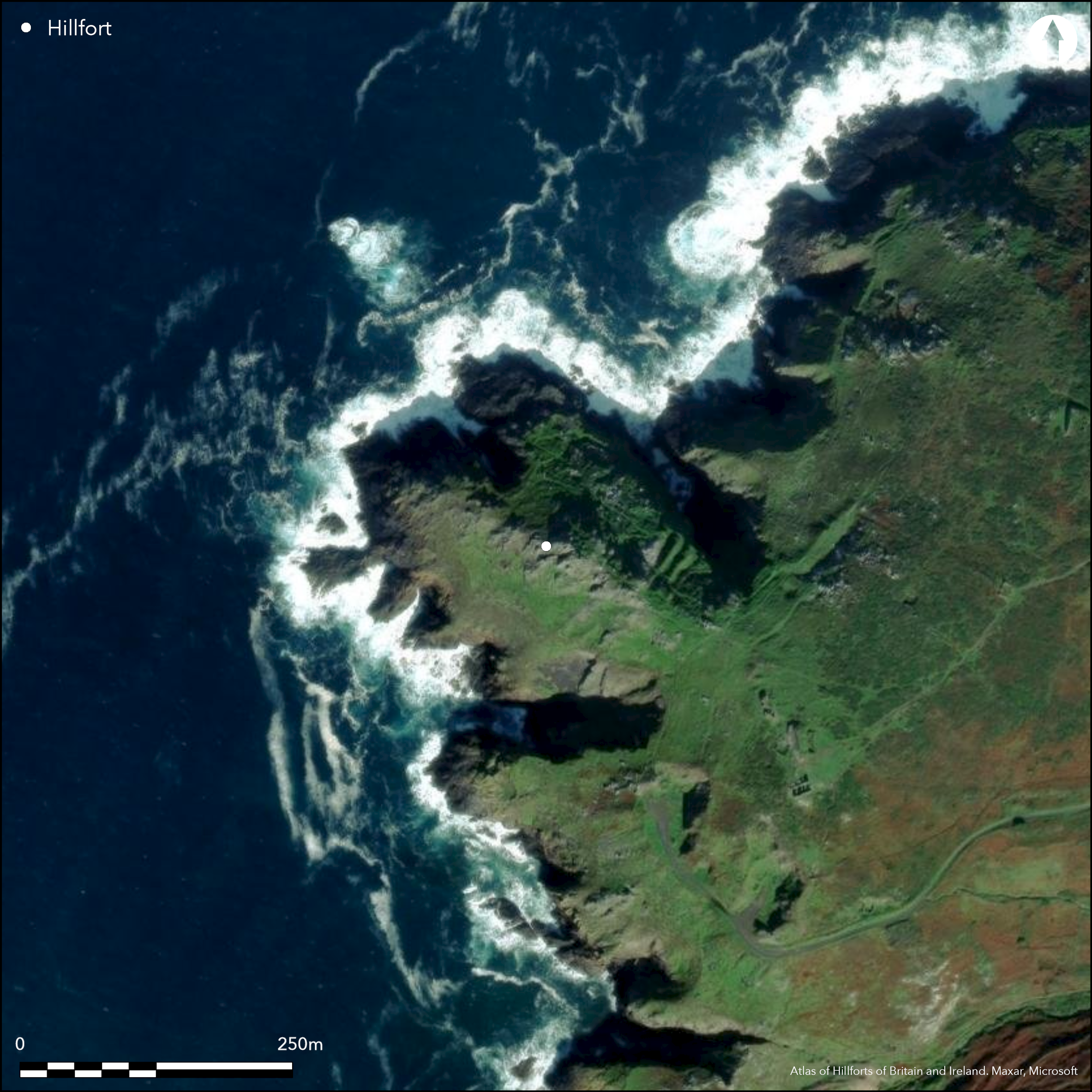
Satellite Imagery
LiDAR 1m DTM Hillshade
Satellite Imagery
Scroll left/right to view further images.
HER: Cornwall and Scilly 29782 (None)
NMR: SW 33 SE 51 (421757)
SM: 1004388
NGR: SW35453263
X: 135460 Y: 32623 (OSGB36)
Promontory fort located on exposed and rocky NW-facing headland between coves of North Zawn and South Zawn. Kenidjack Headland, with sea cliffs, has spine of steep outcrop forming barrier to central approach, but easy access from NE and SW. Defined by three ramparts and rock-cut ditches on the NE side and two on SW side, encloses c. 2ha, but an estimate due to erosion. Best on former. Banks revetted and inner of stone. Possible that sea erosion has taken a third bank on the S. Possible original pathway on each side of headland, between central outcrop and ramparts, pathway, as only way from one side to other is by climbing the outcrops. Interior contains hollows possibly hut circles or evidence of quarrying. Copper ore deposits in cliff. Rocky coastal grassland. Recorded by J. Norden 1728 in Speculi Britanniae Pars. On 1st Ed. OS map (1876). Undated.
Citizen Science: ✗
Reliability of Data: Confirmed
Reliability of Interpretation: Confirmed
X: -634896 Y: 6469599 (EPSG: 3857)
Longitude: -5.7033662261268825 Latitude: 50.134484768191896 (EPSG:4326)
Country: England
Current County or Unitary Authority: Cornwall
Historic County: Cornwall
Current Parish/Community/Council/Townland: St Just
Ramparts visible.
| Extant | ✓ |
| Cropmark | ✗ |
| Likely Destroyed | ✗ |
Rough coastal grassland and much bare rock.
| Woodland | ✗ |
| Commercial Forestry Plantation | ✗ |
| Parkland | ✗ |
| Pasture (Grazing) | ✗ |
| Arable | ✗ |
| Scrub/Bracken | ✗ |
| Bare Outcrop | ✗ |
| Heather/Moorland | ✗ |
| Heath | ✗ |
| Built-up | ✗ |
| Coastal Grassland | ✓ |
| Other | ✗ |
Promontory fort (aka cliff castle) located on exposed and rocky NW-facing headland between coves of North Zawn and South Zawn. Kenidjack Headland, with sea cliffs, has spine of steep outcrop forming barrier to central approach, but easy access from NE and SW.
| Contour Fort | ✗ |
| Partial Contour Fort | ✗ |
| Promontory Fort | ✓ |
| Hillslope Fort | ✗ |
| Level Terrain Fort | ✗ |
| Marsh Fort | ✗ |
| Multiple Enclosure Fort | ✗ |
| Hilltop | ✗ |
| Coastal Promontory | ✓ |
| Inland Promontory | ✗ |
| Valley Bottom | ✗ |
| Knoll/Hillock/Outcrop | ✗ |
| Ridge | ✗ |
| Cliff/Plateau-edge/Scarp | ✗ |
| Hillslope | ✗ |
| Lowland | ✗ |
| Spur | ✗ |
Dominant Topographic Feature: Coastal headland
| North | ✗ |
| Northeast | ✗ |
| East | ✗ |
| Southeast | ✗ |
| South | ✗ |
| Southwest | ✗ |
| West | ✗ |
| Northwest | ✓ |
| Level | ✗ |
Altitude: 46.0m
N/A
None.
Reliability: D - None
| Pre 1200BC | ✗ |
| 1200BC - 800BC | ✗ |
| 800BC - 400BC | ✗ |
| 400BC - AD50 | ✗ |
| AD50 - AD400 | ✗ |
| AD400 - AD 800 | ✗ |
| Post AD800 | ✗ |
| Unknown | ✓ |
| Pre Hillfort: | Late Bronze Age hoard suggesting metalworking found 19th century. |
| Post Hillfort: | None |
Recorded by J. Norden 1726. On 1st Ed. OS map (1876). Recorded by W. C. Borlase 1879. Field investigations Ordnance Survey 1960, 1975.
| 1st Identified Written Reference (1728): | Recorded by J. Norden. |
| 1st Identified Map Depiction (1876): | OS map. |
| Other (1879): | Recorded by W. C. Borlase. |
| Other (2006): | Visited by Hillfort Study Group |
| Other (None): | Field investigations OS. |
Interior contains hollows possibly hut circles or evidence of quarrying.
None
| None | ✓ |
| Spring | ✗ |
| Stream | ✗ |
| Pool | ✗ |
| Flush | ✗ |
| Well | ✗ |
| Other | ✗ |
Interior contains hollows possibly hut circles or evidence of quarrying.
| No Known Features | ✗ |
| Round Stone Structures | ✗ |
| Rectangular Stone Structures | ✗ |
| Curvilinear Platforms | ✗ |
| Other Roundhouse Evidence | ✓ |
| Pits | ✗ |
| Quarry Hollows | ✗ |
| Other | ✓ |
None
| No Known Excavation | ✓ |
| Pits | ✗ |
| Postholes | ✗ |
| Roundhouses | ✗ |
| Rectangular Structures | ✗ |
| Roads/Tracks | ✗ |
| Quarry Hollows | ✗ |
| Other | ✗ |
| Nothing Found | ✗ |
None
| No Known Geophysics | ✓ |
| Pits | ✗ |
| Roundhouses | ✗ |
| Rectangular Structures | ✗ |
| Roads/Tracks | ✗ |
| Quarry Hollows | ✗ |
| Other | ✗ |
| Nothing Found | ✗ |
None
| No Known Finds | ✓ |
| Pottery | ✗ |
| Metal | ✗ |
| Metalworking | ✗ |
| Human Bones | ✗ |
| Animal Bones | ✗ |
| Lithics | ✗ |
| Environmental | ✗ |
| Other | ✗ |
None
| APs Not Checked | ✓ |
| None | ✗ |
| Roundhouses | ✗ |
| Rectangular Structures | ✗ |
| Pits | ✗ |
| Postholes | ✗ |
| Roads/Tracks | ✗ |
| Other | ✗ |
Possible original pathway on each side of headland, between central outcrop and ramparts, pathway, as only way from one side to other is by climbing the outcrops.
| 2: | None |
| 2: | Possible original pathway on each side of headland, between central outcrop and ramparts, pathway, as only way from one side to other is by climbing the outcrops. |
Guard Chambers: ✗
Chevaux de Frise: ✗
| 1. Simple Gap (North east): | Estimated location. |
| 2. Simple Gap (South west): | Estimated location. |
Defined by three ramparts and ditches on the NE side and two on SW side. Best on former. Banks revetted and inner of stone. Possible that sea erosion has taken a third bank on the S.
| Area 1: | 2.0ha. |
| Total: | 2.0ha. |
Total Footprint Area: Noneha.
None
| ✗ | Area a current estimate |
| ✗ | None |
| NE Quadrant: | 3 |
| SE Quadrant: | 0 |
| SW Quadrant: | 2 |
| NW Quadrant: | 0 |
| Total: | 3 |
| Partial Univallate | ✗ |
| Univallate | ✗ |
| Partial Bivallate | ✓ |
| Bivallate | ✗ |
| Partial Multivallate | ✓ |
| Multivallate | ✗ |
| Unknown | ✗ |
| Partial Univallate | ✗ |
| Univallate | ✗ |
| Partial Bivallate | ✗ |
| Bivallate | ✗ |
| Partial Multivallate | ✗ |
| Multivallate | ✗ |
Banks revetted and inner of stone.
| None | ✗ |
| Earthen Bank | ✓ |
| Stone Wall | ✓ |
| Rubble | ✗ |
| Wall-walk | ✗ |
| Evidence of Timber | ✗ |
| Vitrification | ✗ |
| Other Burning | ✗ |
| Palisade | ✗ |
| Counter Scarp Bank | ✗ |
| Berm | ✗ |
| Unfinished | ✗ |
| Other | ✗ |
None
| None | ✗ |
| Earthen Bank | ✗ |
| Stone Wall | ✗ |
| Murus Duplex | ✗ |
| Timber-framed | ✗ |
| Timber-laced | ✗ |
| Vitrification | ✗ |
| Other Burning | ✗ |
| Palisade | ✗ |
| Counter Scarp Bank | ✗ |
| Berm | ✗ |
| Unfinished | ✗ |
| No Known Excavation | ✓ |
| Other | ✗ |
| ✗ | None |
| ✓ | Rock-cut ditches. |
Number of Ditches: 3
| ✗ | None |
Borlase, W.C. Archaeological discoveries in the Parishes of St Just-in-Penwith and Sennen, J Royal Inst Cornwall, 6, 190-212.
Cotton, M.A. 1958-9. Cornish Cliff Castles, Proc West Cornwall Fld Club, 2, 3, 119.
Johnson, N. and Rose, P. 1982. Defended settlement in Cornwall - an illustrated discussion, In ed. D. Miles, The Romano-British countryside: Studies in rural settlement and economy, BAR Brit Ser 103, 151-207.
Norden, J, 1728. Speculi Britanniae Pars.
Page, W. ed. 1906. The Victoria history of the County of Cornwall, Vol I, 453, 460, The Victoria History of the Counties of England.
Russell, V. 1971. West Penwith survey, 38, 50.
Sharpe, A. 1998. An archaeological assessment of Kenidjack Farm, Valley and Cliff, St Just in Penwith, Unpublished report Historic Environment Service, Truro.
Atlas of Hillforts:
Wikidata:
This work is licensed under CC BY-SA 4.0

 and should be cited as:
Lock, Gary and Ralston, Ian. 2024. Atlas of Hillforts of Britain and Ireland. Available at: https://hillforts.arch.ox.ac.uk
Document Version 1.1