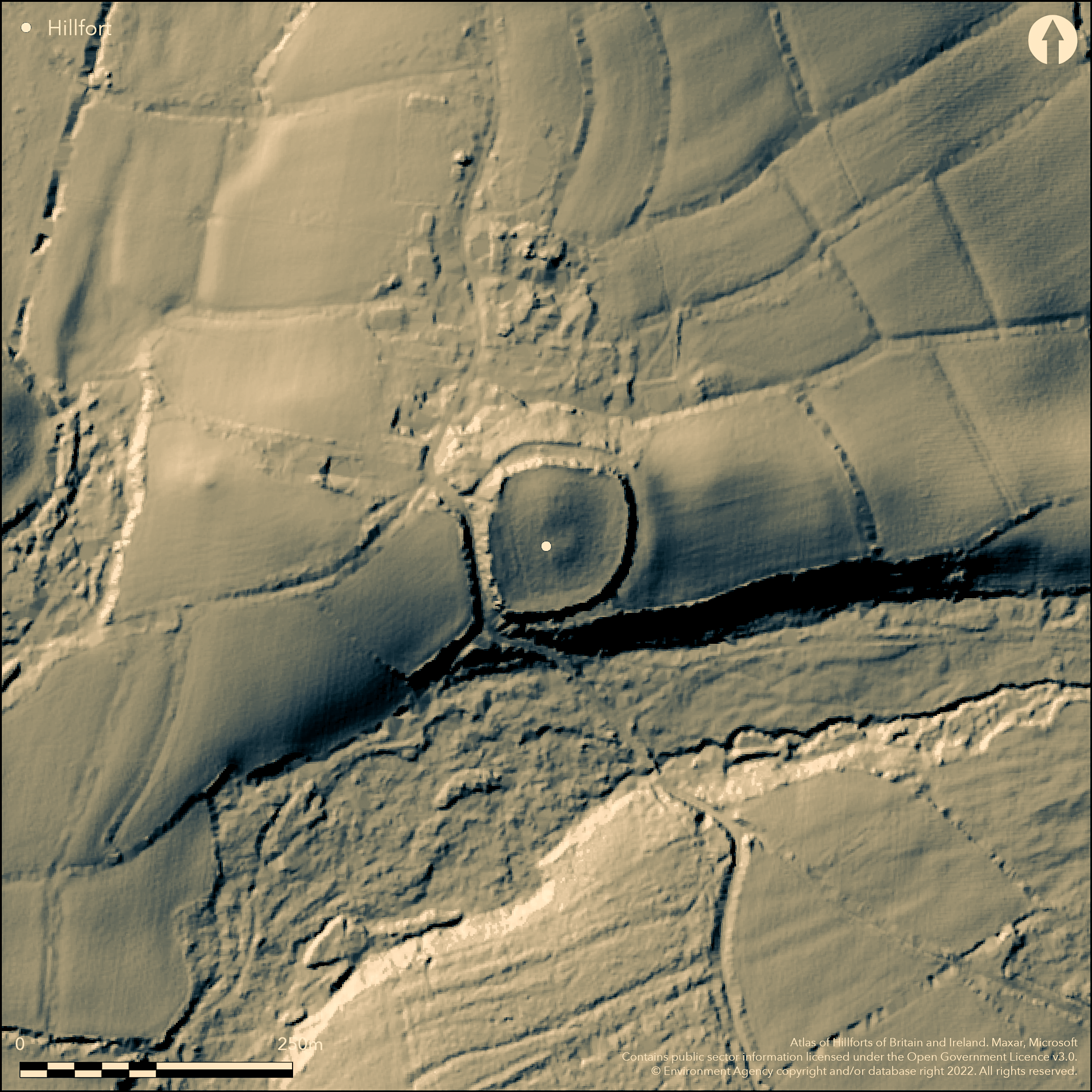
LiDAR 1m DTM Hillshade
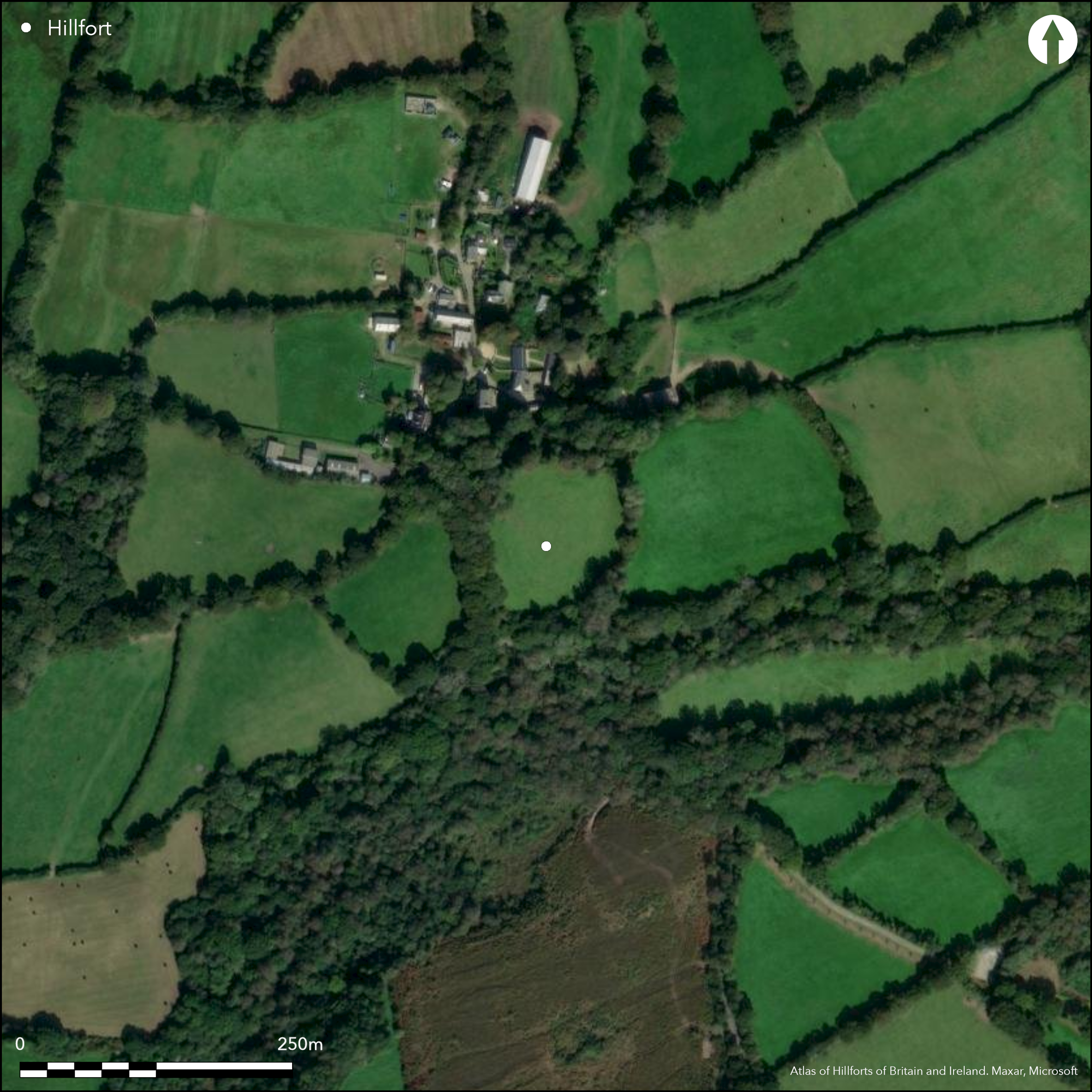
Satellite Imagery
LiDAR 1m DTM Hillshade
Satellite Imagery
Scroll left/right to view further images.
HER: Cornwall and Scilly 21483 (None)
NMR: SW 96 SE 6 (430589)
SM: 1005452
NGR: SW977636
X: 197725 Y: 63650 (OSGB36)
Small, possible bivallate, contour hillfort or round, located on small knoll on upper slopes of very prominent ridge overlooking valley of a tributary of the River Camel, with stream confluences to N and E, in central Cornwall. Moderate slopes. Roughly oval in shape, of c. 1.2ha, measuring c. 20m N-S by 110m E-W. Defined by two ramparts with largely infilled ditches. Inner rampart has steep, almost perpendicular, bank c. 2.3m to 3.6m high. Where visible, outer rampart to c. 4.3m high on N, steep slope, side and 1.3m on gentler E. Steep natural slope utilised as outer defence on S. Ditch and outer bank destroyed by road on SW and W. Any original entrance not visible. Antiquarian reference to third rampart suggested by Hals (1750) cannot be identified and doubtful whether ever existed. Alleged artificial mounds in interior not visible, but ploughed. Interior improved pasture with wooded surrounds. On 1st Ed. OS map (1881). Undated.
Citizen Science: ✗
Reliability of Data: Confirmed
Reliability of Interpretation: Unconfirmed
X: -539893 Y: 6522424 (EPSG: 3857)
Longitude: -4.849942855942567 Latitude: 50.437693119170966 (EPSG:4326)
Country: England
Current County or Unitary Authority: Cornwall
Historic County: Cornwall
Current Parish/Community/Council/Townland: St Wenn
Fair. Interior ploughed. Ditch and outer bank destroyed by road on SW and W.
| Extant | ✓ |
| Cropmark | ✗ |
| Likely Destroyed | ✓ |
Interior improved pasture with wooded surrounds. Road.
| Woodland | ✗ |
| Commercial Forestry Plantation | ✗ |
| Parkland | ✗ |
| Pasture (Grazing) | ✓ |
| Arable | ✗ |
| Scrub/Bracken | ✗ |
| Bare Outcrop | ✗ |
| Heather/Moorland | ✗ |
| Heath | ✗ |
| Built-up | ✗ |
| Coastal Grassland | ✗ |
| Other | ✓ |
Small, possible bivallate, contour hillfort or round, located on small knoll on upper slopes of very prominent ridge overlooking valley of a tributary of the River Camel, with stream confluences to N and E, in central Cornwall. Moderate slopes.
| Contour Fort | ✓ |
| Partial Contour Fort | ✗ |
| Promontory Fort | ✗ |
| Hillslope Fort | ✗ |
| Level Terrain Fort | ✗ |
| Marsh Fort | ✗ |
| Multiple Enclosure Fort | ✗ |
| Hilltop | ✗ |
| Coastal Promontory | ✗ |
| Inland Promontory | ✗ |
| Valley Bottom | ✗ |
| Knoll/Hillock/Outcrop | ✓ |
| Ridge | ✓ |
| Cliff/Plateau-edge/Scarp | ✗ |
| Hillslope | ✗ |
| Lowland | ✗ |
| Spur | ✗ |
Dominant Topographic Feature: Small knoll.
| North | ✗ |
| Northeast | ✗ |
| East | ✗ |
| Southeast | ✗ |
| South | ✗ |
| Southwest | ✗ |
| West | ✗ |
| Northwest | ✗ |
| Level | ✓ |
Altitude: 107.0m
N/A
None.
Reliability: D - None
| Pre 1200BC | ✗ |
| 1200BC - 800BC | ✗ |
| 800BC - 400BC | ✗ |
| 400BC - AD50 | ✗ |
| AD50 - AD400 | ✗ |
| AD400 - AD 800 | ✗ |
| Post AD800 | ✗ |
| Unknown | ✓ |
| Pre Hillfort: | None |
| Post Hillfort: | None |
Name first recorded 1309 and derived from the Cornish 'dyn' meaning fort. Mention by William Hals 1750. On 1st Ed. OS map (1881). Field investigation Ordnance Survey 1977.
| 1st Identified Written Reference (1309): | Name first recorded 1309 and derived from the Cornish 'dyn' meaning fort |
| Other (1750): | Mention by William Hals. |
| 1st Identified Map Depiction (1881): | OS map. |
| Other (1977): | Field investigation OS. |
Alleged artificial mounds in interior not visible, but ploughed
None
| None | ✓ |
| Spring | ✗ |
| Stream | ✗ |
| Pool | ✗ |
| Flush | ✗ |
| Well | ✗ |
| Other | ✗ |
Alleged artificial mounds in interior not visible, but ploughed
| No Known Features | ✗ |
| Round Stone Structures | ✗ |
| Rectangular Stone Structures | ✗ |
| Curvilinear Platforms | ✗ |
| Other Roundhouse Evidence | ✗ |
| Pits | ✗ |
| Quarry Hollows | ✗ |
| Other | ✓ |
None
| No Known Excavation | ✓ |
| Pits | ✗ |
| Postholes | ✗ |
| Roundhouses | ✗ |
| Rectangular Structures | ✗ |
| Roads/Tracks | ✗ |
| Quarry Hollows | ✗ |
| Other | ✗ |
| Nothing Found | ✗ |
None
| No Known Geophysics | ✓ |
| Pits | ✗ |
| Roundhouses | ✗ |
| Rectangular Structures | ✗ |
| Roads/Tracks | ✗ |
| Quarry Hollows | ✗ |
| Other | ✗ |
| Nothing Found | ✗ |
None
| No Known Finds | ✓ |
| Pottery | ✗ |
| Metal | ✗ |
| Metalworking | ✗ |
| Human Bones | ✗ |
| Animal Bones | ✗ |
| Lithics | ✗ |
| Environmental | ✗ |
| Other | ✗ |
None
| APs Not Checked | ✓ |
| None | ✗ |
| Roundhouses | ✗ |
| Rectangular Structures | ✗ |
| Pits | ✗ |
| Postholes | ✗ |
| Roads/Tracks | ✗ |
| Other | ✗ |
Cannot be identified.
| 0: | None |
| 2: | None |
Guard Chambers: ✗
Chevaux de Frise: ✗
Defined by two ramparts with largely infilled ditches. Inner rampart has steep, almost perpendicular, bank c. 2.3m to 3.6m high. Where visible, outer rampart to c. 4.3m high on N, steep slope, side and 1.3m on gentler E. Steep natural slope utilised as outer defence on S. Ditch and outer bank destroyed by road on SW and W.
| Area 1: | 1.2ha. |
| Total: | 1.2ha. |
Total Footprint Area: Noneha.
None
| ✗ | None |
| ✓ | It is possible that the second rampart is a counterscarp bank, but this cannot be verified as ditches largely infilled. |
| NE Quadrant: | 2 |
| SE Quadrant: | 1 |
| SW Quadrant: | 1 |
| NW Quadrant: | 2 |
| Total: | 2 |
| Partial Univallate | ✓ |
| Univallate | ✗ |
| Partial Bivallate | ✓ |
| Bivallate | ✗ |
| Partial Multivallate | ✗ |
| Multivallate | ✗ |
| Unknown | ✗ |
| Partial Univallate | ✗ |
| Univallate | ✗ |
| Partial Bivallate | ✗ |
| Bivallate | ✗ |
| Partial Multivallate | ✗ |
| Multivallate | ✗ |
It is possible that the second rampart is a counterscarp bank, but this cannot be verified.
| None | ✗ |
| Earthen Bank | ✓ |
| Stone Wall | ✗ |
| Rubble | ✗ |
| Wall-walk | ✗ |
| Evidence of Timber | ✗ |
| Vitrification | ✗ |
| Other Burning | ✗ |
| Palisade | ✗ |
| Counter Scarp Bank | ✗ |
| Berm | ✗ |
| Unfinished | ✗ |
| Other | ✗ |
None
| None | ✗ |
| Earthen Bank | ✗ |
| Stone Wall | ✗ |
| Murus Duplex | ✗ |
| Timber-framed | ✗ |
| Timber-laced | ✗ |
| Vitrification | ✗ |
| Other Burning | ✗ |
| Palisade | ✗ |
| Counter Scarp Bank | ✗ |
| Berm | ✗ |
| Unfinished | ✗ |
| No Known Excavation | ✓ |
| Other | ✗ |
| ✗ | None |
| ✓ | Ditches largely infilled and buried features. |
Number of Ditches: 2
| ✗ | None |
Hals, W. 1750. Complete history of Cornwall, Part II being the parochial history, Exeter: Andrew Brice.
Polsue, J. ed. 1872. In Lake's Parochial History of the County of Cornwall, IV, 315, 317.
Page, W. ed. 1906. The Victoria History of the County of Cornwall, 1, London: James Street, 470.
Atlas of Hillforts:
Wikidata:
This work is licensed under CC BY-SA 4.0

 and should be cited as:
Lock, Gary and Ralston, Ian. 2024. Atlas of Hillforts of Britain and Ireland. Available at: https://hillforts.arch.ox.ac.uk
Document Version 1.1