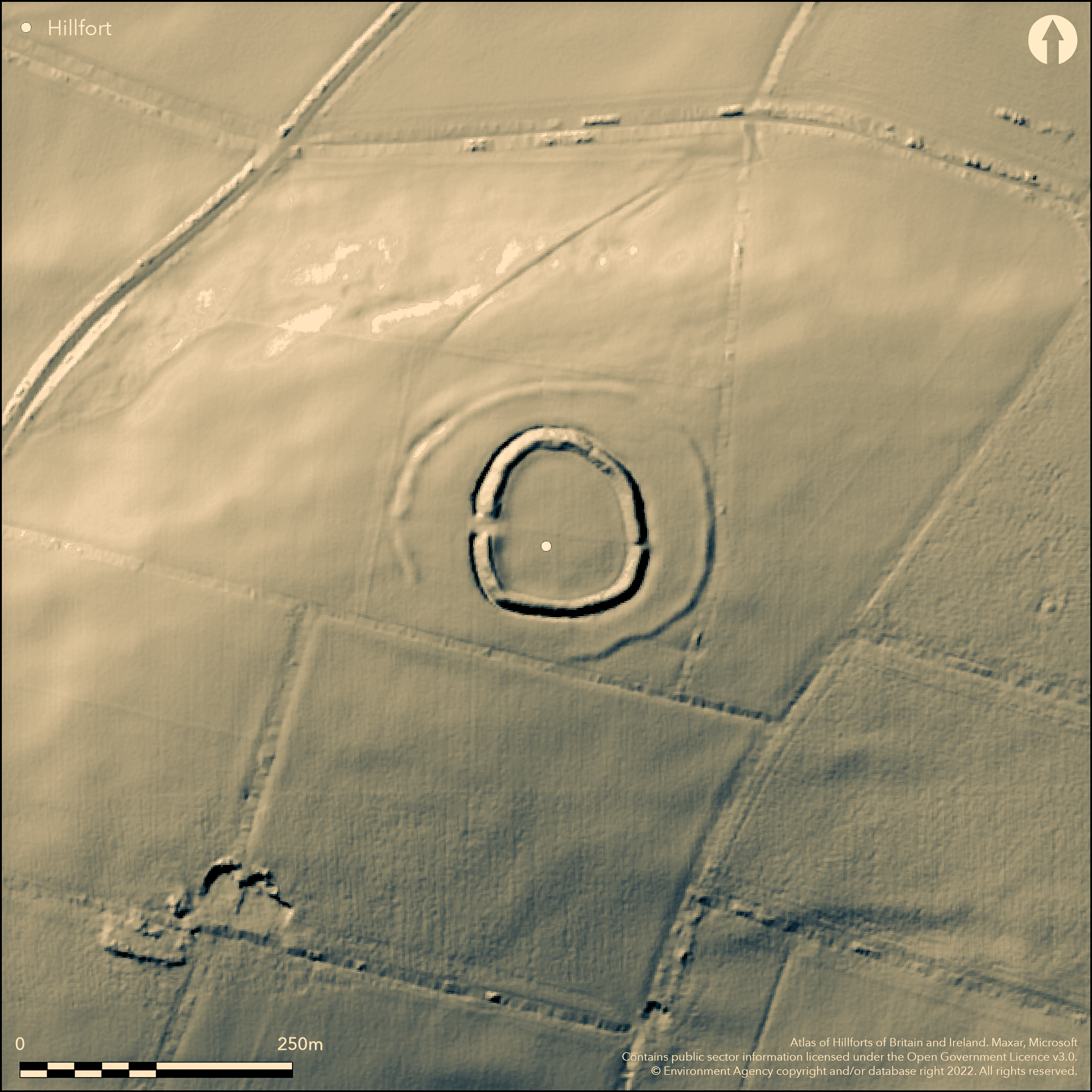
LiDAR 1m DTM Hillshade
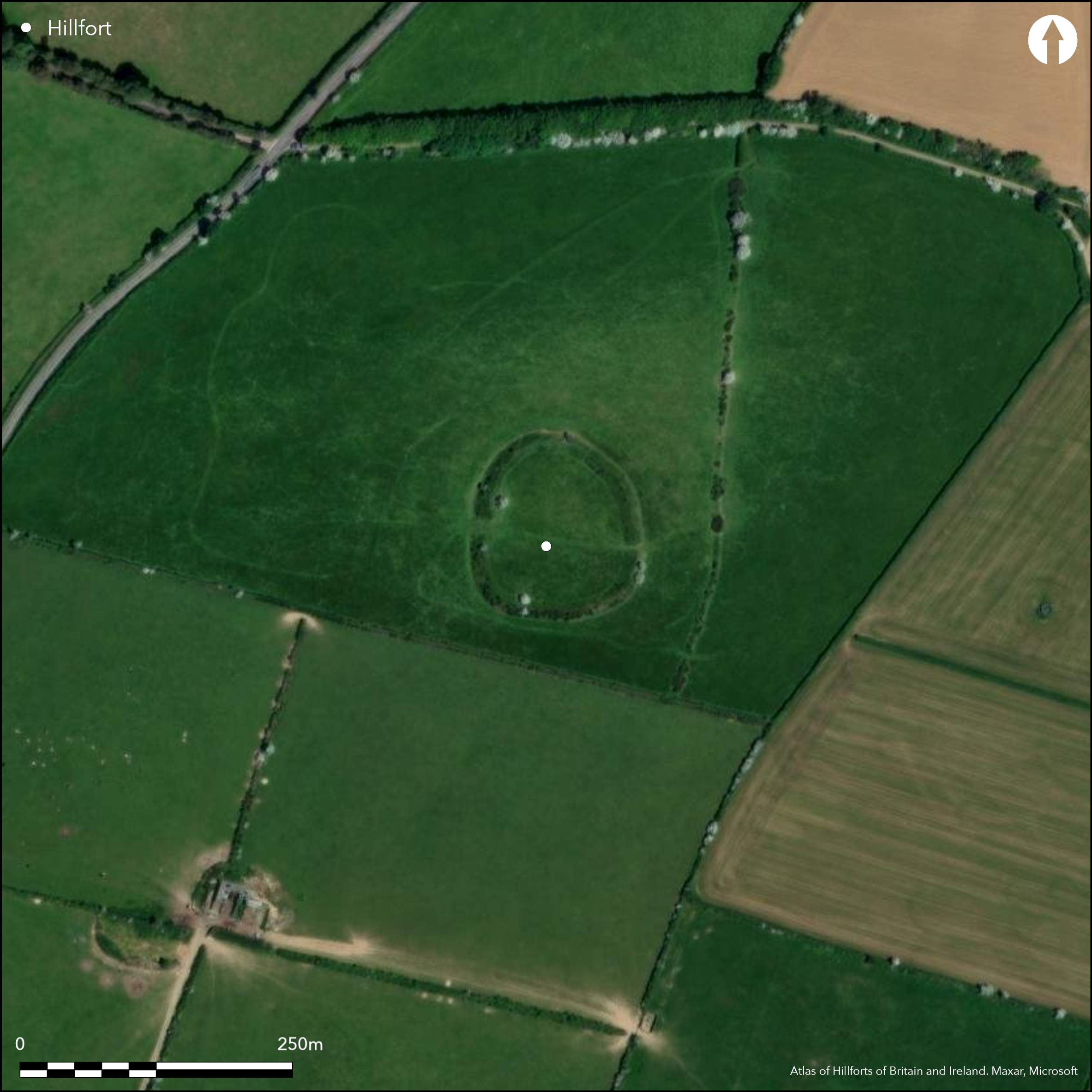
Satellite Imagery
LiDAR 1m DTM Hillshade
Satellite Imagery
Scroll left/right to view further images.
HER: Cornwall and Scilly 25125 (None)
NMR: SX 15 NE 1 (432087)
SM: 106635
NGR: SX188594
X: 218831 Y: 59472 (OSGB36)
Small, possible bivallate, hillfort located on NW-facing slopes near the summit of Bury Down, Lanraeth, above West Looe River on E. Steep surrounding slopes, moderate to summit on E. In essence, a badly damaged and interrupted outer bank to 1m high and outer ditch lie outside a much better preserved round, with bank to 2m high and outer ditch to 2m deep, and may possibly be remains of an early Neolithic causewayed enclosure. Inner enclosure c. 100m by 80m with area c. 0.4ha. The outer rampart roughly circular, 170m diameter, c. 2ha, comprising bank to 2m high with shallow outer ditch around E and N, deteriorating into intermittent ditch and dump construction on W with a probable intended entrance. Any continuation around S not visible and this outer rampart possibly unfinished. Questions therefore remain. Geophysics and trial excavations 1994 found V-shaped ditch profile, possibly unfinished part of the hillfort. Some original dry-stone walling on NE and SE. Wide entrance on W where ditch broken and rampart terminals thickened and slightly inturned. Narrower entrance on E not inturned and now partially blocked. No artefacts. Improved pasture. On 1st Ed. OS map (1882).
Citizen Science: ✗
Reliability of Data: Unconfirmed
Reliability of Interpretation: Unconfirmed
X: -506618 Y: 6517071 (EPSG: 3857)
Longitude: -4.5510280930122 Latitude: 50.407053696260164 (EPSG:4326)
Country: England
Current County or Unitary Authority: Cornwall
Historic County: Cornwall
Current Parish/Community/Council/Townland: Lanraeth
Badly damaged.
| Extant | ✓ |
| Cropmark | ✗ |
| Likely Destroyed | ✗ |
Improved pasture with occasional trees.
| Woodland | ✗ |
| Commercial Forestry Plantation | ✗ |
| Parkland | ✗ |
| Pasture (Grazing) | ✓ |
| Arable | ✗ |
| Scrub/Bracken | ✗ |
| Bare Outcrop | ✗ |
| Heather/Moorland | ✗ |
| Heath | ✗ |
| Built-up | ✗ |
| Coastal Grassland | ✗ |
| Other | ✗ |
Small, possible bivallate, hillfort located on NW-facing slopes near the summit of Bury Down, Lanraeth, above West Looe River on E. Steep surrounding slopes, moderate to summit on E.
| Contour Fort | ✗ |
| Partial Contour Fort | ✗ |
| Promontory Fort | ✗ |
| Hillslope Fort | ✓ |
| Level Terrain Fort | ✗ |
| Marsh Fort | ✗ |
| Multiple Enclosure Fort | ✗ |
| Hilltop | ✗ |
| Coastal Promontory | ✗ |
| Inland Promontory | ✗ |
| Valley Bottom | ✗ |
| Knoll/Hillock/Outcrop | ✗ |
| Ridge | ✗ |
| Cliff/Plateau-edge/Scarp | ✗ |
| Hillslope | ✓ |
| Lowland | ✗ |
| Spur | ✗ |
Dominant Topographic Feature: Hillslope
| North | ✗ |
| Northeast | ✗ |
| East | ✗ |
| Southeast | ✗ |
| South | ✗ |
| Southwest | ✗ |
| West | ✗ |
| Northwest | ✓ |
| Level | ✗ |
Altitude: 175.0m
N/A
None.
Reliability: D - None
| Pre 1200BC | ✗ |
| 1200BC - 800BC | ✗ |
| 800BC - 400BC | ✗ |
| 400BC - AD50 | ✗ |
| AD50 - AD400 | ✗ |
| AD400 - AD 800 | ✗ |
| Post AD800 | ✗ |
| Unknown | ✓ |
| Pre Hillfort: | Possible causewayed enclosure. Large-scale resistivity survey carried out in the adjacent field and on site 1994 showed outer ditch to be discontinuous, the ditch segments having rounded ends and distinct causeways, and on this evidence a Neolithic origin for the site was suggested. |
| Post Hillfort: | None |
First mentioned by W. Borlase 1758. On the 1813 OS 1" map. Described by D. and S. Lysons 1814. On 1st Ed. OS map (1882). Field investigation Ordnance Survey 1972. Geophysics and trial excavations 1994 (no report or further details). Watching Brief 1995.
| 1st Identified Written Reference (1758): | First mentioned by W. Borlase. |
| 1st Identified Map Depiction (1813): | On the 1813 OS 1" map. |
| Other (1814): | Described by D. and S. Lysons. |
| Other (1882): | OS map. |
| Other (1972): | Field investigation OS. |
| Excavation (1994): | Trial excavations. |
| Geophysical Survey (1994): | To determine Neolithic connotations to site. |
| Other (1995): | Watching Brief. |
None.
None
| None | ✓ |
| Spring | ✗ |
| Stream | ✗ |
| Pool | ✗ |
| Flush | ✗ |
| Well | ✗ |
| Other | ✗ |
None
| No Known Features | ✓ |
| Round Stone Structures | ✗ |
| Rectangular Stone Structures | ✗ |
| Curvilinear Platforms | ✗ |
| Other Roundhouse Evidence | ✗ |
| Pits | ✗ |
| Quarry Hollows | ✗ |
| Other | ✗ |
None
| No Known Excavation | ✓ |
| Pits | ✗ |
| Postholes | ✗ |
| Roundhouses | ✗ |
| Rectangular Structures | ✗ |
| Roads/Tracks | ✗ |
| Quarry Hollows | ✗ |
| Other | ✗ |
| Nothing Found | ✗ |
Large-scale resistivity survey carried out in the adjacent field and on site 1994 showed outer ditch to be discontinuous, the ditch segments having rounded ends and distinct causeways, and on this evidence a Neolithic origin for the site was suggested.
| No Known Geophysics | ✓ |
| Pits | ✗ |
| Roundhouses | ✗ |
| Rectangular Structures | ✗ |
| Roads/Tracks | ✗ |
| Quarry Hollows | ✗ |
| Other | ✗ |
| Nothing Found | ✗ |
None
| No Known Finds | ✓ |
| Pottery | ✗ |
| Metal | ✗ |
| Metalworking | ✗ |
| Human Bones | ✗ |
| Animal Bones | ✗ |
| Lithics | ✗ |
| Environmental | ✗ |
| Other | ✗ |
None
| APs Not Checked | ✓ |
| None | ✗ |
| Roundhouses | ✗ |
| Rectangular Structures | ✗ |
| Pits | ✗ |
| Postholes | ✗ |
| Roads/Tracks | ✗ |
| Other | ✗ |
Wide entrance on W where ditch broken and rampart terminals thickened and slightly inturned. Narrower entrance on E not inturned and now partially blocked.
| 2: | None |
| 2: | None |
Guard Chambers: ✗
Chevaux de Frise: ✗
| 1. In-turned (West): | Slightly inturned. |
| 2. Blocked (East): | Part blocked. |
In essence, a badly damaged and interrupted outer bank to 1m high and outer ditch lie outside a much better preserved round, with bank to 2m high and outer ditch to 2m deep, and may possibly be remains of an early Neolithic causewayed enclosure. The outer rampart roughly circular, 170m diameter, comprising bank to 2m high with shallow outer ditch around E and N, deteriorating into intermittent ditch and dump construction on W with a probable intended entrance. Any continuation around S not visible and this outer rampart possibly unfinished. Questions therefore remain. Geophysics and trial excavations 1994 found V-shaped ditch profile, possibly unfinished part of the hillfort. Some original dry stone walling on NE and SE.
| Area 1: | 0.4ha. |
| Area 2: | 2.0ha. |
| Total: | 2.0ha. |
Total Footprint Area: Noneha.
None
| ✗ | None |
| ✓ | None |
| NE Quadrant: | 2 |
| SE Quadrant: | 2 |
| SW Quadrant: | 2 |
| NW Quadrant: | 2 |
| Total: | 2 |
| Partial Univallate | ✗ |
| Univallate | ✗ |
| Partial Bivallate | ✗ |
| Bivallate | ✓ |
| Partial Multivallate | ✗ |
| Multivallate | ✗ |
| Unknown | ✗ |
| Partial Univallate | ✗ |
| Univallate | ✗ |
| Partial Bivallate | ✗ |
| Bivallate | ✗ |
| Partial Multivallate | ✗ |
| Multivallate | ✗ |
Some original dry-stone walling on NE and SE. Outer rampart possibly unfinished.
| None | ✗ |
| Earthen Bank | ✓ |
| Stone Wall | ✓ |
| Rubble | ✗ |
| Wall-walk | ✗ |
| Evidence of Timber | ✗ |
| Vitrification | ✗ |
| Other Burning | ✗ |
| Palisade | ✗ |
| Counter Scarp Bank | ✗ |
| Berm | ✗ |
| Unfinished | ✓ |
| Other | ✗ |
No details.
| None | ✓ |
| Earthen Bank | ✗ |
| Stone Wall | ✗ |
| Murus Duplex | ✗ |
| Timber-framed | ✗ |
| Timber-laced | ✗ |
| Vitrification | ✗ |
| Other Burning | ✗ |
| Palisade | ✗ |
| Counter Scarp Bank | ✗ |
| Berm | ✗ |
| Unfinished | ✗ |
| No Known Excavation | ✗ |
| Other | ✗ |
| ✗ | None |
| ✓ | Geophysics and trial excavations 1994 found V-shaped ditch profile, |
Number of Ditches: 2
| ✗ | None |
Borlase, W. 1758, The Natural History of Cornwall, 325.
Lysons, D. and Lysons, S. 1814. Magna Britannia. Vol 3, Cornwall, 258.
Page, W. ed. 1906. The Victoria history of the County of Cornwall, Vol I, 466, The Victoria History of the Counties of England.
Atlas of Hillforts:
Wikidata:
This work is licensed under CC BY-SA 4.0

 and should be cited as:
Lock, Gary and Ralston, Ian. 2024. Atlas of Hillforts of Britain and Ireland. Available at: https://hillforts.arch.ox.ac.uk
Document Version 1.1