LiDAR 1m DTM Hillshade
Satellite Imagery
LiDAR 1m DTM Hillshade
Satellite Imagery
Scroll left/right to view further images.
HER: South Gloucestershire SG2334 (None)
NMR: ST 69 SW 1 (634303)
SM: 1013187
NGR: ST 6110 9270
X: 361130 Y: 192700 (OSGB36)
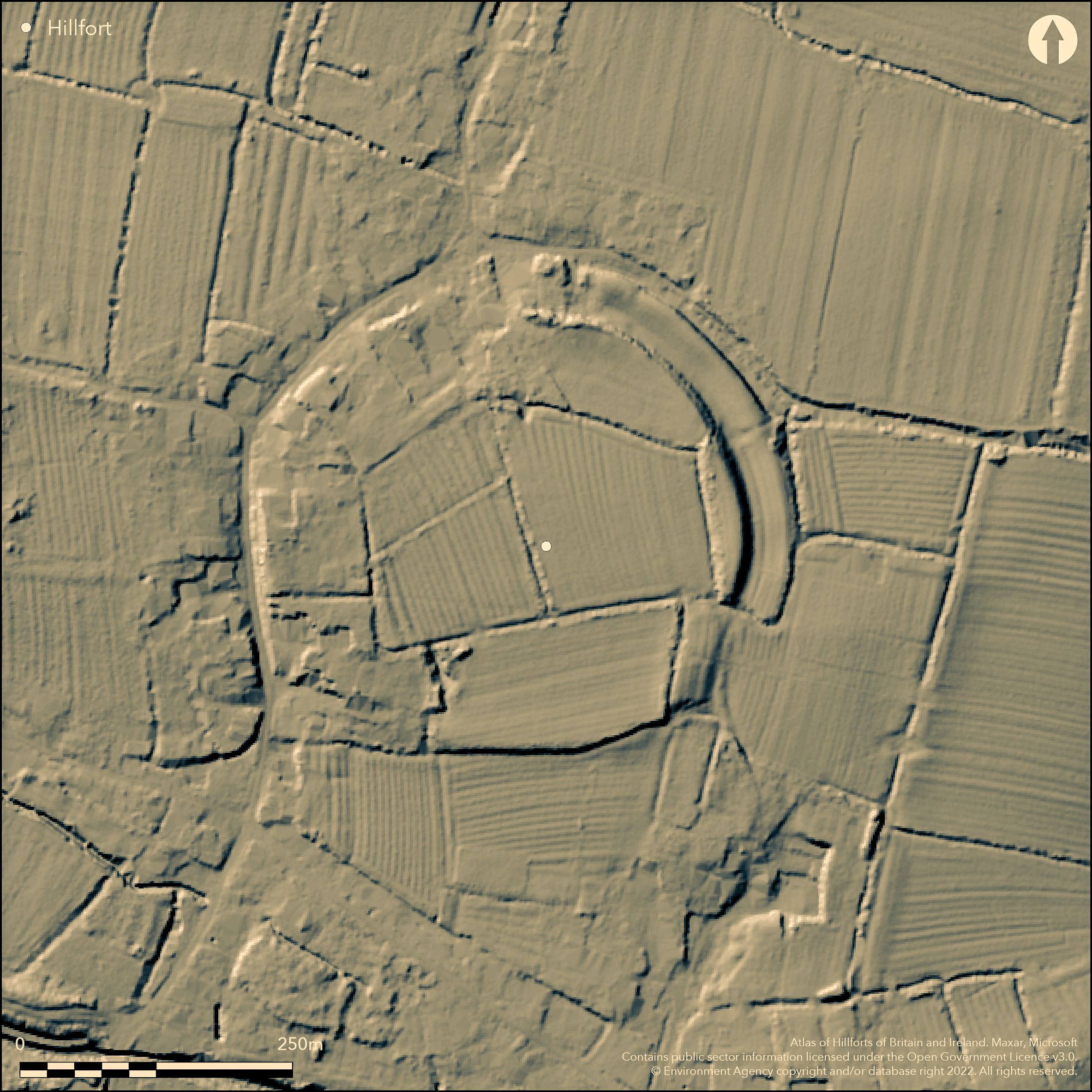
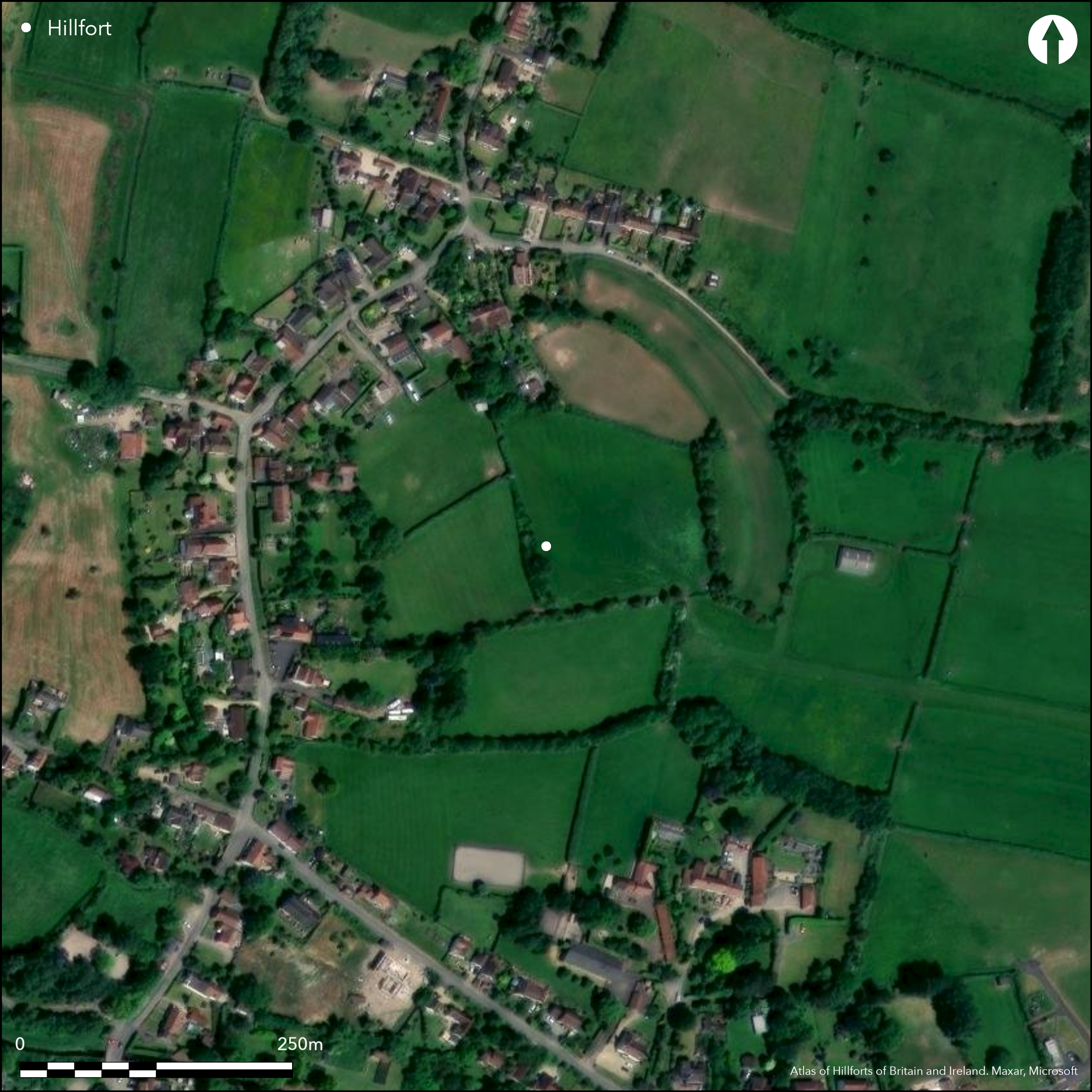
Unusual and possible, bivallate, marsh fort of uncertain date and origin set in slightly elevated position at 14m OD, now much destroyed by buildings and road construction at Oldbury-upon-Severn village. Its location, in what may have been former a low-lying island within tidal saltings and marshland, and fronting the navigable River Pill, is unusual for a hillfort location, with other factors such as uncertain dating of pottery, making interpretation uncertain. Place-name Oldbury means `old fortification or stronghold? (from ald + bur), but Oldbury-upon-Severn is not one of Alfred the Great's listed burhs in the Burghal Hidage. It is recorded that a Viking fleet sheltered in the Severn and it has been suggested that the site may be of Danish origin, although most of the ditch had been infilled with silt by early Medieval period and the area appears continuously occupied since at least 13th-14th centuries. Remaining earthworks, mapped by Severn Vale NMP on 2013 aerial photographs and 2010 LiDAR imagery project, now show two curvilinear, parallel, earthwork banks with medial curvilinear ditch, possibly forming part of E boundary of a possible D-shaped hillfort, but medieval ridge and furrow cultivation within the enclosure may have masked actual shape, estimated at 4.0ha enclosed. Outer bank 249m long by to 11m wide from N to ESE side. Inner parallel bank of two sections, one 57m long by 6m wide, the other 92m long by 14m wide. The ditch between the two is 91m long by 4m wide. To S further short 56m section of the earthworks may define the turn W at the SE corner of the defences. Entrance not visible and conjectural, but possibly on slightly higher ground to N. Suggested platform probably part of field levelling. Series of small-scale excavations found possible (disputed) Iron Age pottery and quantity of medieval pottery in the ditch. Evidence for iron working in interior and speculation whether site acted as trading post with Forest of Dean. On 1st Ed. OS map (1881).
Citizen Science: ✓
Reliability of Data: Unconfirmed
Reliability of Interpretation: Unconfirmed
X: -285313 Y: 6733806 (EPSG: 3857)
Longitude: -2.5630142840829473 Latitude: 51.631713421914775 (EPSG:4326)
Country: England
Current County or Unitary Authority: South Gloucestershire
Historic County: Gloucestershire
Current Parish/Community/Council/Townland: Oldbury-on-Severn
Much destroyed by buildings and road construction, but N and NE sections visible.
| Extant | ✓ |
| Cropmark | ✗ |
| Likely Destroyed | ✓ |
Within Oldbury-upon-Severn village.
| Woodland | ✗ |
| Commercial Forestry Plantation | ✗ |
| Parkland | ✗ |
| Pasture (Grazing) | ✓ |
| Arable | ✗ |
| Scrub/Bracken | ✓ |
| Bare Outcrop | ✗ |
| Heather/Moorland | ✗ |
| Heath | ✗ |
| Built-up | ✓ |
| Coastal Grassland | ✗ |
| Other | ✓ |
Unusual and possible, bivallate, marsh fort of uncertain date and origin set in slightly elevated position at 14m OD, now virtually destroyed by buildings and road construction at Oldbury-upon-Severn village.
| Contour Fort | ✗ |
| Partial Contour Fort | ✗ |
| Promontory Fort | ✗ |
| Hillslope Fort | ✗ |
| Level Terrain Fort | ✗ |
| Marsh Fort | ✓ |
| Multiple Enclosure Fort | ✗ |
| Hilltop | ✗ |
| Coastal Promontory | ✗ |
| Inland Promontory | ✗ |
| Valley Bottom | ✗ |
| Knoll/Hillock/Outcrop | ✗ |
| Ridge | ✗ |
| Cliff/Plateau-edge/Scarp | ✗ |
| Hillslope | ✗ |
| Lowland | ✓ |
| Spur | ✗ |
Dominant Topographic Feature: Low lying rise.
| North | ✗ |
| Northeast | ✗ |
| East | ✗ |
| Southeast | ✗ |
| South | ✗ |
| Southwest | ✗ |
| West | ✗ |
| Northwest | ✗ |
| Level | ✓ |
Altitude: 14.0m
N/A
Dating conjecture. Series of small-scale excavations found possible (disputed) Iron Age pottery and quantity of of medieval pottery in the ditch. Five Roman pottery sherds, but many Roman coins. Ditch already infilled and most of bank removed by medieval times. Evaluation trench 1990 for determination of scheduled monument consent sectioned ditch and likely Iron Age date was confirmed.
Reliability: B - Medium
| Pre 1200BC | ✗ |
| 1200BC - 800BC | ✗ |
| 800BC - 400BC | ✓ |
| 400BC - AD50 | ✓ |
| AD50 - AD400 | ✗ |
| AD400 - AD 800 | ✗ |
| Post AD800 | ✗ |
| Unknown | ✗ |
| Pre Hillfort: | None |
| Post Hillfort: | None |
| Artefactual: | Pottery and Roman coins. |
On 1st Ed. OS map (1881). Excavation Bristol Archaeological Research Group 1960's. Small rescue excavation by R. Howell and R. Iles, 1978-9. Excavation R. Iles 1982. Evaluation J.P.G. Erskine 1990. Watching Briefs - various 1990, 2000, 2007. LiDar imagery Environment Agency 2010. Mapped in Severn Vale NMP Gloucestershire CC 2013-1016.
| 1st Identified Map Depiction (1881): | OS map. |
| Excavation (1982): | R. Iles. |
| Other (1990): | Evaluation J.G.P. Erskine. |
| Other (1990): | Watching Brief J.G.P. Erskine. |
| Other (2000): | Watching Brief Cotswold Archaeological Trust. |
| Other (2007): | Watching Brief Avon Archaeological Unit. |
| Other (2007): | Watching Brief Cotswold Archaeology. |
| LiDAR Survey (2010): | Environment Agency. |
| Excavation (None): | Bristol Archaeological Research Group. |
| Excavation (None): | R. Howell and R. Iles. |
| Other (None): | Severn Vale NMP Gloucestershire CC Archaeology Service.. |
Possible pit and undated postholes found in excavations. Possible Iron Age and quantity of medieval pottery. Evidence of metal working. Many Roman coins.
None
| None | ✓ |
| Spring | ✗ |
| Stream | ✗ |
| Pool | ✗ |
| Flush | ✗ |
| Well | ✗ |
| Other | ✗ |
None
| No Known Features | ✓ |
| Round Stone Structures | ✗ |
| Rectangular Stone Structures | ✗ |
| Curvilinear Platforms | ✗ |
| Other Roundhouse Evidence | ✗ |
| Pits | ✗ |
| Quarry Hollows | ✗ |
| Other | ✗ |
Possible pit and undated postholes found in excavations.
| No Known Excavation | ✗ |
| Pits | ✓ |
| Postholes | ✓ |
| Roundhouses | ✗ |
| Rectangular Structures | ✗ |
| Roads/Tracks | ✗ |
| Quarry Hollows | ✗ |
| Other | ✗ |
| Nothing Found | ✗ |
None
| No Known Geophysics | ✓ |
| Pits | ✗ |
| Roundhouses | ✗ |
| Rectangular Structures | ✗ |
| Roads/Tracks | ✗ |
| Quarry Hollows | ✗ |
| Other | ✗ |
| Nothing Found | ✗ |
Possible Iron Age and quantity of medieval pottery. Evidence of iron-working, associated with probable Iron Age occupation layer found in interior. Five Roman pottery sherds, but many Roman coins.
| No Known Finds | ✗ |
| Pottery | ✓ |
| Metal | ✗ |
| Metalworking | ✓ |
| Human Bones | ✗ |
| Animal Bones | ✗ |
| Lithics | ✗ |
| Environmental | ✗ |
| Other | ✓ |
NO APPARENT FEATURES
| APs Not Checked | ✓ |
| None | ✗ |
| Roundhouses | ✗ |
| Rectangular Structures | ✗ |
| Pits | ✗ |
| Postholes | ✗ |
| Roads/Tracks | ✗ |
| Other | ✗ |
Entrance not visible and conjectural, but possibly on slightly higher ground to N.
| None: | Not recorded. |
| 2: | Uncertain. |
Guard Chambers: ✗
Chevaux de Frise: ✗
| 1. Simple Gap (North): | Entrance not visible and conjectural, but possibly on slightly higher ground to N. |
Two curvilinear, parallel, earthwork banks with medial curvilinear ditch, possibly forming part of E boundary of a possible D-shaped hillfort, but medieval ridge and furrow cultivation within the enclosure may have masked actual shape. Outer bank 249m long by to 11m wide from N to ESE side. Inner parallel bank of two sections, one 57m long by 6m wide, the other 92m long by 14m wide. The ditch between the two is 91m long by 4m wide. To S further short 56m section of the earthworks may define the turn W at the SE corner of the defences. Small section dug by R. Iles through outer bank and ditch prior to building of bungalow. Ditch already infilled and most of bank removed by medieval times. Evaluation trench 1990 for determination of scheduled monument consent sectioned ditch and likely Iron Age date was confirmed.
| Area 1: | 4.0ha. |
| Total: | 4.0ha. |
Total Footprint Area: Noneha.
None
| ✗ | None |
| ✗ | None |
| NE Quadrant: | 2 |
| SE Quadrant: | 2 |
| SW Quadrant: | 0 |
| NW Quadrant: | 0 |
| Total: | 2 |
| Partial Univallate | ✗ |
| Univallate | ✗ |
| Partial Bivallate | ✓ |
| Bivallate | ✗ |
| Partial Multivallate | ✗ |
| Multivallate | ✗ |
| Unknown | ✗ |
| Partial Univallate | ✗ |
| Univallate | ✗ |
| Partial Bivallate | ✗ |
| Bivallate | ✗ |
| Partial Multivallate | ✗ |
| Multivallate | ✗ |
None
| None | ✗ |
| Earthen Bank | ✓ |
| Stone Wall | ✗ |
| Rubble | ✗ |
| Wall-walk | ✗ |
| Evidence of Timber | ✗ |
| Vitrification | ✗ |
| Other Burning | ✗ |
| Palisade | ✗ |
| Counter Scarp Bank | ✗ |
| Berm | ✗ |
| Unfinished | ✗ |
| Other | ✗ |
Small section dug by R. Iles through outer bank and ditch prior to building of bungalow. Ditch already infilled and most of bank removed by medieval times. Evaluation trench 1990 for determination of scheduled monument consent sectioned ditch and likely Iron Age date was confirmed.
| None | ✗ |
| Earthen Bank | ✗ |
| Stone Wall | ✗ |
| Murus Duplex | ✗ |
| Timber-framed | ✗ |
| Timber-laced | ✗ |
| Vitrification | ✗ |
| Other Burning | ✗ |
| Palisade | ✗ |
| Counter Scarp Bank | ✗ |
| Berm | ✗ |
| Unfinished | ✗ |
| No Known Excavation | ✗ |
| Other | ✓ |
| ✗ | None |
| ✓ | Medial ditch. Ditch already infilled and most of bank removed by medieval times. |
Number of Ditches: 1
| ✗ | None |
Anon 1980. Note, Bristol Archaeological Research Group Review, 1, 36.
Erskine, J .P. 1990. The Toot, Camp Road, Oldbury on Severn, Avon: Site Specific Archaeological Evaluation, Unpublished monograph Avon County Council.
Erskine, J. G. P. 1990. Land adjoining Cherry Tree Cottage, Camp Road, Oldbury-on-Severn, Avon: observations and recording of foundation trenches, Unpublished monograph Avon County Council.
Havard, T. 2000. Camp House, Oldbury-on-Severn, South Gloucestershire: archaeological watching brief, Report No 001232, Cotswold Arcaheological Trust.
Iiles, R. 1983. Note, Bristol and Avon Archaeol, Bristol & Avon Archaeological Society, 2, 49.
Rowe, E. 2007. Camp Cottage, Oldbury-on-Severn, South Gloucestershire. Archaeological Watching Brief, Cotswold Archaeology.
Young, D. 2007. Wisteria House, Camp Road, Oldbury upon Severn: archaeological watching brief, Avon Archaeological Unit.
Atlas of Hillforts:
Wikidata:
This work is licensed under CC BY-SA 4.0![]()
![]()
![]() and should be cited as:
and should be cited as:
Lock, Gary and Ralston, Ian. 2024. Atlas of Hillforts of Britain and Ireland. Available at: https://hillforts.arch.ox.ac.uk
Document Version 1.1