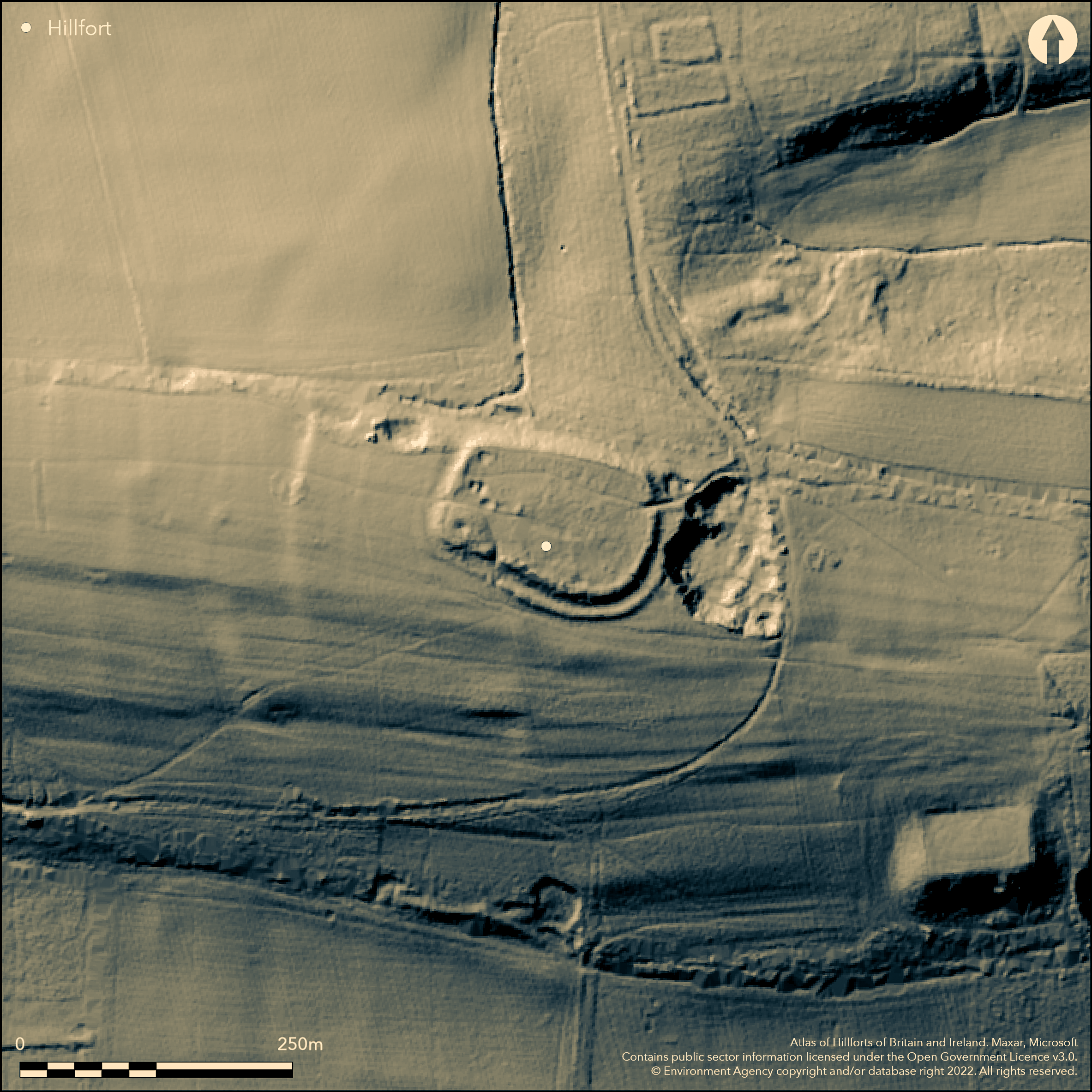
LiDAR 1m DTM Hillshade
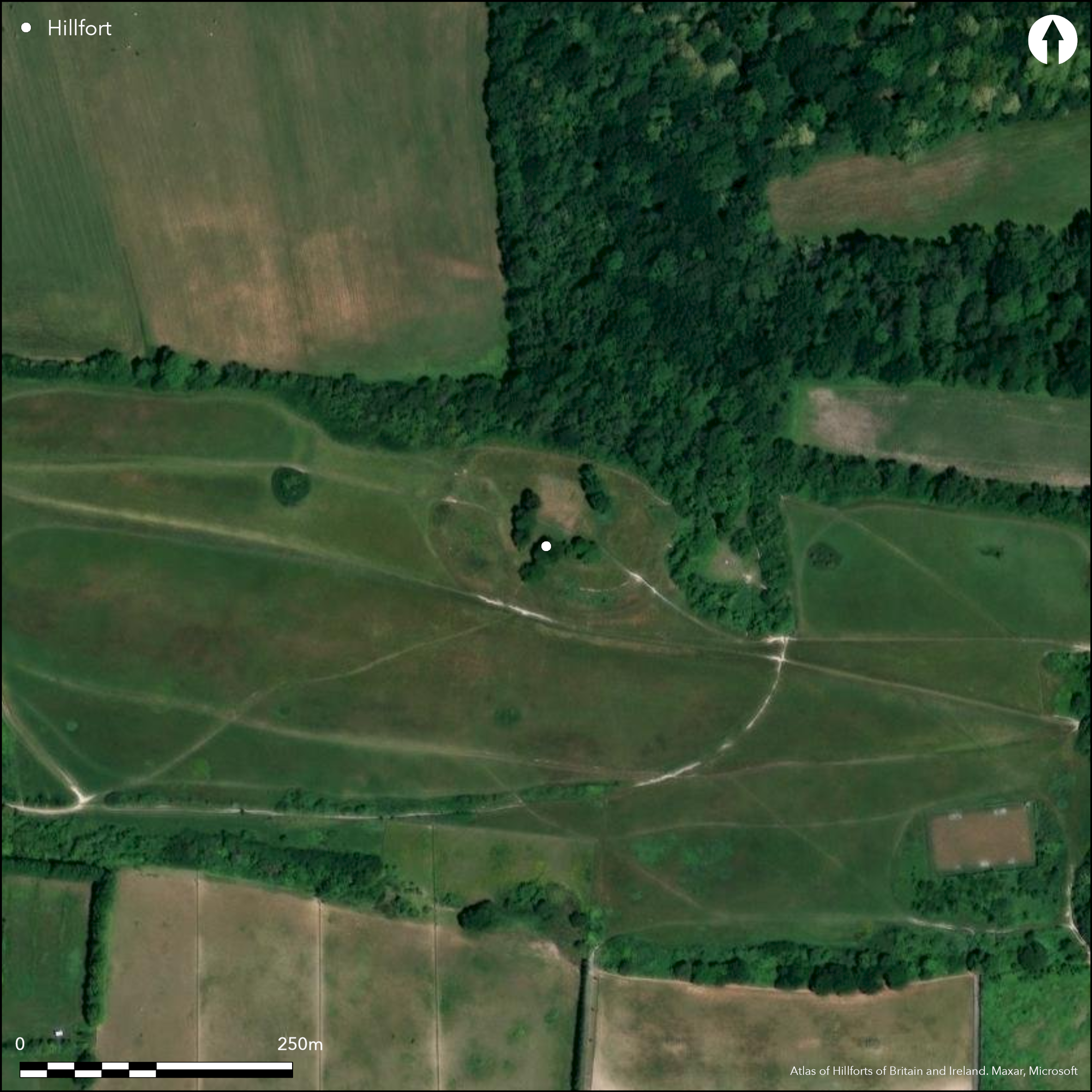
Satellite Imagery
LiDAR 1m DTM Hillshade
Satellite Imagery
Scroll left/right to view further images.
HER: West Sussex MWS6402 (None)
NMR: TQ 00 SE 1 (392735)
SM: 1015877
NGR: TQ09270434
X: 509270 Y: 104340 (OSGB36)
Small, possible contour hillfort or defended enclosure located on isolated chalk hill above the West Sussex coastal plain. Steep surrounding slopes. One of the few Rams Hill type enclosures (Atlas No 0167), which were located in S England during the Bronze Age. They appear to have had specific functions, maybe of a seasonal ceremonial basis, and are probably better classified as a specific monument type in their own right rather than a hillfort per se. Site is oval in shape and aligned roughly E-W enclosing c. 1ha. On S bank to c. 0.5m high and c. 8m wide, surrounded by c. 10m wide ditch. To N where steep slopes defences now only simple scarp. S ramparts flanked by second, smaller, bank, an original counterscarp, but much ploughed, as are W ramparts. Entrance is 8m wide gap through S ramparts. Small excavations from 1857-1947 showed ramparts remodelled at least once during later prehistoric period. Traces of contemporary buildings and substantial pottery fragments and other artefacts indicate intensive use during the middle and late Bronze Age. Fragments of Romano-British pottery sherds also show reuse after Roman invasion of AD 43. Anglo-Saxon cemetery of 5th to 6th century AD date (over 150 cremation and inhumation burials) in interior. Associated structures found in SE sector. Later medieval (12th century) post mill, surviving as circular mound c. 14m in diameter and up to c. 0.5m high, in SW. During World War II site of, now demolished, radar station. Old chalk pit just outside to E. Fair condition, but ramparts crossed and damaged by public access paths. Amenity grassland. On 1st Ed. OS map (1876).
Citizen Science: ✗
Reliability of Data: Confirmed
Reliability of Interpretation: Unconfirmed
X: -50078 Y: 6590965 (EPSG: 3857)
Longitude: -0.4498585633399802 Latitude: 50.82822790298609 (EPSG:4326)
Country: England
Current County or Unitary Authority: West Sussex
Historic County: Sussex
Current Parish/Community/Council/Townland: Ferring
Fair condition, but ramparts crossed and damaged by public access paths. Most of trees on site blown down in 1987 storm.
| Extant | ✓ |
| Cropmark | ✗ |
| Likely Destroyed | ✗ |
Rough grassland and scattered trees.
| Woodland | ✓ |
| Commercial Forestry Plantation | ✗ |
| Parkland | ✗ |
| Pasture (Grazing) | ✓ |
| Arable | ✗ |
| Scrub/Bracken | ✗ |
| Bare Outcrop | ✗ |
| Heather/Moorland | ✗ |
| Heath | ✗ |
| Built-up | ✗ |
| Coastal Grassland | ✗ |
| Other | ✗ |
Small, possible contour hillfort or defended enclosure located on isolated chalk hill above the West Sussex coastal plain. Steep surrounding slopes.
| Contour Fort | ✓ |
| Partial Contour Fort | ✗ |
| Promontory Fort | ✗ |
| Hillslope Fort | ✗ |
| Level Terrain Fort | ✗ |
| Marsh Fort | ✗ |
| Multiple Enclosure Fort | ✗ |
| Hilltop | ✓ |
| Coastal Promontory | ✗ |
| Inland Promontory | ✗ |
| Valley Bottom | ✗ |
| Knoll/Hillock/Outcrop | ✗ |
| Ridge | ✗ |
| Cliff/Plateau-edge/Scarp | ✗ |
| Hillslope | ✗ |
| Lowland | ✗ |
| Spur | ✗ |
Dominant Topographic Feature: Hill top.
| North | ✗ |
| Northeast | ✗ |
| East | ✗ |
| Southeast | ✗ |
| South | ✗ |
| Southwest | ✗ |
| West | ✗ |
| Northwest | ✗ |
| Level | ✓ |
Altitude: 82.0m
N/A
Small excavations from 1857-1947 showed defences remodelled at least once during later prehistoric period. Traces of contemporary buildings and substantial pottery fragments and other artefacts indicate intensive use during the middle and late Bronze Age. Fragments of Romano-British pottery sherds also show reuse after Roman invasion of AD 43. During monitoring and excavation of a water pipeline trench below hillfort revealed possible prehistoric boundary ditches and large pit with much Romano-British debris.
Reliability: B - Medium
| Pre 1200BC | ✗ |
| 1200BC - 800BC | ✓ |
| 800BC - 400BC | ✗ |
| 400BC - AD50 | ✗ |
| AD50 - AD400 | ✓ |
| AD400 - AD 800 | ✗ |
| Post AD800 | ✗ |
| Unknown | ✗ |
| Pre Hillfort: | None |
| Post Hillfort: | None |
| Artefactual: | Pottery evidence. |
| Other: | Contemporary buildings evidence. |
On 1st Ed. OS map (1876). Excavation G.V. Irving 1857. Excavation A.H. Lane Fox 1868. Excavation E. Henty 1895-1901. Excavation A.E. Wilson 1939. Excavation A.E. Wilson 1947. Excavations 1988, 1996 M. Gardiner - no details. Geophysical surveys 1991 and c. 2013 - no details. Measured survey Landscapes of War Recording Project English Heritage 2008-09.
| Excavation (1857): | G.V. Irving. |
| Excavation (1868): | A.H. Lane Fox. |
| 1st Identified Map Depiction (1876): | OS map. |
| Excavation (1939): | A.E. Wilson. |
| Excavation (1947): | A.E. Wilson. |
| Other (1975): | Visited by Hillfort Study Group |
| Excavation (None): | Excavations M. Gardiner - no details. |
| Geophysical Survey (None): | No details. |
| Other (None): | Measured survey Landscapes of War Recording Project English Heritage. |
Traces of contemporary buildings and substantial pottery fragments and other artefacts indicate intensive use during the middle and late Bronze Age. Fragments of Romano-British pottery sherds also show reuse after Roman invasion of AD 43. Bronze Age dagger. Late bronze Age hoard (1000 BC - 701 BC).
None
| None | ✓ |
| Spring | ✗ |
| Stream | ✗ |
| Pool | ✗ |
| Flush | ✗ |
| Well | ✗ |
| Other | ✗ |
None
| No Known Features | ✓ |
| Round Stone Structures | ✗ |
| Rectangular Stone Structures | ✗ |
| Curvilinear Platforms | ✗ |
| Other Roundhouse Evidence | ✗ |
| Pits | ✗ |
| Quarry Hollows | ✗ |
| Other | ✗ |
Traces of contemporary buildings.
| No Known Excavation | ✗ |
| Pits | ✗ |
| Postholes | ✗ |
| Roundhouses | ✗ |
| Rectangular Structures | ✗ |
| Roads/Tracks | ✗ |
| Quarry Hollows | ✗ |
| Other | ✓ |
| Nothing Found | ✗ |
No details of geophysics.
| No Known Geophysics | ✗ |
| Pits | ✗ |
| Roundhouses | ✗ |
| Rectangular Structures | ✗ |
| Roads/Tracks | ✗ |
| Quarry Hollows | ✗ |
| Other | ✓ |
| Nothing Found | ✗ |
Substantial pottery fragments and other artefacts indicate intensive use during the middle and late Bronze Age. Bronze Age dagger. Late bronze Age hoard (1000 BC - 701 BC).
| No Known Finds | ✗ |
| Pottery | ✓ |
| Metal | ✗ |
| Metalworking | ✗ |
| Human Bones | ✗ |
| Animal Bones | ✗ |
| Lithics | ✗ |
| Environmental | ✗ |
| Other | ✓ |
None
| APs Not Checked | ✓ |
| None | ✗ |
| Roundhouses | ✗ |
| Rectangular Structures | ✗ |
| Pits | ✗ |
| Postholes | ✗ |
| Roads/Tracks | ✗ |
| Other | ✗ |
Entrance is 8m wide gap through S ramparts may be entrance, but unclear, and this gap has been suggested as access to the medieval post mill, with an original entrance on the E.
| 5: | Public access damage. |
| 2: | None |
Guard Chambers: ✗
Chevaux de Frise: ✗
| 1. Simple Gap (South): | Unclear entrance - 8m wide gap through ramparts. |
On S bank to c. 0.5m high and c. 8m wide, surrounded by c. 10m wide ditch. To N where steep slopes defences now only simple scarp. S ramparts flanked by second, smaller, bank, an original counterscarp, but much ploughed, as are W ramparts. Investigations during 19th and 20th centuries showed defences remodelled at least once during later prehistoric period.
| Area 1: | 1.0ha. |
| Total: | 1.0ha. |
Total Footprint Area: Noneha.
None
| ✓ | Investigations during 19th and 20th centuries showed defences remodelled at least once during later prehistoric period. Traces |
| ✓ | Second bank on S a counterscarp. |
| NE Quadrant: | 1 |
| SE Quadrant: | 1 |
| SW Quadrant: | 1 |
| NW Quadrant: | 1 |
| Total: | 1 |
| Partial Univallate | ✗ |
| Univallate | ✓ |
| Partial Bivallate | ✗ |
| Bivallate | ✗ |
| Partial Multivallate | ✗ |
| Multivallate | ✗ |
| Unknown | ✗ |
| Partial Univallate | ✗ |
| Univallate | ✗ |
| Partial Bivallate | ✗ |
| Bivallate | ✗ |
| Partial Multivallate | ✗ |
| Multivallate | ✗ |
Original counterscarp bank on S.
| None | ✗ |
| Earthen Bank | ✓ |
| Stone Wall | ✗ |
| Rubble | ✗ |
| Wall-walk | ✗ |
| Evidence of Timber | ✗ |
| Vitrification | ✗ |
| Other Burning | ✗ |
| Palisade | ✗ |
| Counter Scarp Bank | ✓ |
| Berm | ✗ |
| Unfinished | ✗ |
| Other | ✗ |
None
| None | ✗ |
| Earthen Bank | ✓ |
| Stone Wall | ✗ |
| Murus Duplex | ✗ |
| Timber-framed | ✗ |
| Timber-laced | ✗ |
| Vitrification | ✗ |
| Other Burning | ✗ |
| Palisade | ✗ |
| Counter Scarp Bank | ✗ |
| Berm | ✗ |
| Unfinished | ✗ |
| No Known Excavation | ✗ |
| Other | ✗ |
| ✗ | None |
| ✓ | None |
Number of Ditches: 1
| ✗ | None |
Gardiner, M, Excavations at Highdown Hill, 1988, 1996, unpublished excavation report.
Hamilton, S. and Manley, J.1997. Points of view. Prominent enclosures in 1st millennium Sussex, Sussex Archaeol Coll, 135, 93-112.
Hamilton, S. and Manley, J. 2001. Hillforts, monumentality and place: a chronological and topographic review of first millennium BC hillforts of southeast England, European J Archaeol, 4.1, 7-42.
Wilson, A. E. 1940. Report On The Excavations on Highdown Hill, Sussex, August 1939, Sussex Archaeol Coll, 81, 173-203.
Wilson, A. E. 1950. Excavations on Highdown Hill, 1947, Sussex Archaeol Coll, 89, 163-178.
Atlas of Hillforts:
Wikidata:
This work is licensed under CC BY-SA 4.0

 and should be cited as:
Lock, Gary and Ralston, Ian. 2024. Atlas of Hillforts of Britain and Ireland. Available at: https://hillforts.arch.ox.ac.uk
Document Version 1.1