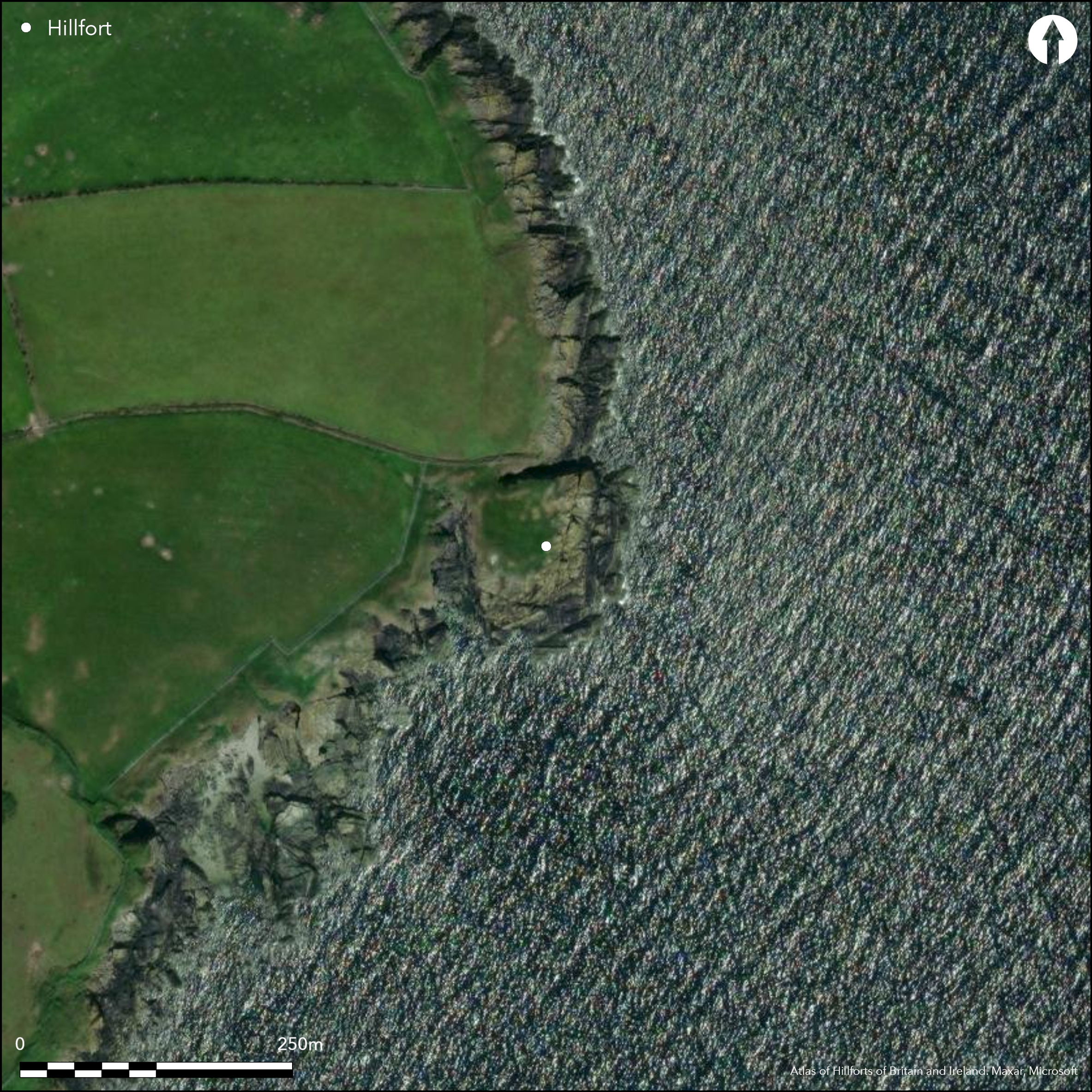
Satellite Imagery
Satellite Imagery
HER: Isle of Man 559 (None)
NMR: None (None)
SM: None
NGR: SC48858985
X: 248850 Y: 489850 (OSGB36)
Coastal promontory fort located on prominent SE-facing headland of Gob ny Garvain jutting out into sea at S end of Port Mooar on NE coast of island, Precipitous, rocky sea cliffs, c. 18m ASL, to N, E and to SW, moderate slope inland to N-NNW, where 20m wide gap. Lozenge-shaped, its longest axis NE-SW c. 50m across, with internal area roughly estimated at c. 0.2ha-0.25ha, the site is larger than a number of the coastal promontory forts of the island, and more akin to Burroo Ned (Atlas No 3228), although no possible interior structures are visible at Gob ny Garvain. Clear views along coast to N and S, with fort on Maughold Head (Atlas No 3336) close to N. Defined by two banks and associated ditches cutting off the narrow neck of land on N-NNW, curving to SW for c. 10m before tapering out. The site has been subject to considerable erosion, with encroachment by boundary hedge, wall and fence to outer bank and ditch, landward, over the years. The Ordnance Survey 1955 found inner bank to 4m wide at base and to 1m high, with parallel outer ditch before mutilated outer bank, 2m high to an outer ditch bottom, ditch itself to 3.5m wide and c. 0.6m deep. No entrance was visible to inner bank, but possibly to outer. The outer bank and ditch now appear to have been eroded further and flattened out in part or whole, but inner bank visible, though mutilated, and best to NW. Circular hollow in inner bank now used for modern access into site, could be site of original, but unclear. Interior of grass, with small undulation in NE possibly indicating feature. On 1st Ed. OS map (1870).
Citizen Science: ✗
Reliability of Data: Confirmed
Reliability of Interpretation: Confirmed
X: -481266 Y: 7223723 (EPSG: 3857)
Longitude: -4.323285897828433 Latitude: 54.2818834589238 (EPSG:4326)
Country: Isle of Man
Current County or Unitary Authority: Garff
Historic County: Garff
Current Parish/Community/Council/Townland: Maughold
Site much eroded, especially outer bank and ditch, where also affected by modern boundary hedge, and and fence.
| Extant | ✓ |
| Cropmark | ✗ |
| Likely Destroyed | ✓ |
Coastal grassland and bare rock.
| Woodland | ✗ |
| Commercial Forestry Plantation | ✗ |
| Parkland | ✗ |
| Pasture (Grazing) | ✗ |
| Arable | ✗ |
| Scrub/Bracken | ✗ |
| Bare Outcrop | ✗ |
| Heather/Moorland | ✗ |
| Heath | ✗ |
| Built-up | ✗ |
| Coastal Grassland | ✓ |
| Other | ✗ |
Coastal promontory fort located on prominent SE-facing headland of Gob ny Garvain jutting out into sea at S end of Port Mooar on NE coast of island, Precipitous, rocky sea cliffs, c. 18m ASL, to N, E and to SW, moderate slope inland to N-NNW, where 20m wide gap.
| Contour Fort | ✗ |
| Partial Contour Fort | ✗ |
| Promontory Fort | ✓ |
| Hillslope Fort | ✗ |
| Level Terrain Fort | ✗ |
| Marsh Fort | ✗ |
| Multiple Enclosure Fort | ✗ |
| Hilltop | ✗ |
| Coastal Promontory | ✓ |
| Inland Promontory | ✗ |
| Valley Bottom | ✗ |
| Knoll/Hillock/Outcrop | ✗ |
| Ridge | ✗ |
| Cliff/Plateau-edge/Scarp | ✗ |
| Hillslope | ✗ |
| Lowland | ✗ |
| Spur | ✗ |
Dominant Topographic Feature: Coastal promontory
| North | ✗ |
| Northeast | ✗ |
| East | ✓ |
| Southeast | ✗ |
| South | ✗ |
| Southwest | ✗ |
| West | ✗ |
| Northwest | ✗ |
| Level | ✗ |
Altitude: 18.0m
N/A
Possibly of Iron Age date, with reuse in medieval period, but no definite conclusions on this.
Reliability: C - Low
| Pre 1200BC | ✗ |
| 1200BC - 800BC | ✗ |
| 800BC - 400BC | ✗ |
| 400BC - AD50 | ✓ |
| AD50 - AD400 | ✗ |
| AD400 - AD 800 | ✓ |
| Post AD800 | ✗ |
| Unknown | ✗ |
| Pre Hillfort: | None |
| Post Hillfort: | None |
On 1st Ed. OS map (1870). Ornance Survey investigation 1955. Field survey J. Woodcock 1999. Field visit University of Liverpool 2010.
| 1st Identified Map Depiction (1870): | OS map. |
| Other (1955): | OS investigation. |
| Other (1999): | Field survey J. Woodcock. |
| Other (2010): | Field visit University of Liverpool. |
Small undulation in NE possibly indicating feature.
None
| None | ✓ |
| Spring | ✗ |
| Stream | ✗ |
| Pool | ✗ |
| Flush | ✗ |
| Well | ✗ |
| Other | ✗ |
Small undulation in NE possibly indicating feature.
| No Known Features | ✗ |
| Round Stone Structures | ✗ |
| Rectangular Stone Structures | ✗ |
| Curvilinear Platforms | ✗ |
| Other Roundhouse Evidence | ✗ |
| Pits | ✗ |
| Quarry Hollows | ✗ |
| Other | ✓ |
None
| No Known Excavation | ✓ |
| Pits | ✗ |
| Postholes | ✗ |
| Roundhouses | ✗ |
| Rectangular Structures | ✗ |
| Roads/Tracks | ✗ |
| Quarry Hollows | ✗ |
| Other | ✗ |
| Nothing Found | ✗ |
None
| No Known Geophysics | ✓ |
| Pits | ✗ |
| Roundhouses | ✗ |
| Rectangular Structures | ✗ |
| Roads/Tracks | ✗ |
| Quarry Hollows | ✗ |
| Other | ✗ |
| Nothing Found | ✗ |
None
| No Known Finds | ✓ |
| Pottery | ✗ |
| Metal | ✗ |
| Metalworking | ✗ |
| Human Bones | ✗ |
| Animal Bones | ✗ |
| Lithics | ✗ |
| Environmental | ✗ |
| Other | ✗ |
None
| APs Not Checked | ✓ |
| None | ✗ |
| Roundhouses | ✗ |
| Rectangular Structures | ✗ |
| Pits | ✗ |
| Postholes | ✗ |
| Roads/Tracks | ✗ |
| Other | ✗ |
No definite entrance visible, but undulations in banks could indicate entrance. Circular hollow in inner bank now used for modern access into site, could be site of original, but unclear.
| 2: | Circular hollow in inner bank now used for modern access into site. |
| 2: | Probable entrance on NW, but unclear |
Guard Chambers: ✗
Chevaux de Frise: ✗
| 1. Simple Gap (North west): | Conjecture only. |
Defined by two banks and associated ditches cutting off the narrow neck of land on N-NNW, curving to SW for c. 10m before tapering out. The site has been subject to considerable erosion, with encroachment by boundary hedge, wall and fence to outer bank and ditch, landward, over the years. The Ordnance Survey 1955 found inner bank to 4m wide at base and to 1m high, with parallel outer ditch before mutilated outer bank, 2m high to an outer ditch bottom, ditch itself to 3.5m wide and c. 0.6m deep.
| Area 1: | 0.22ha. |
| Total: | 0.22ha. |
Total Footprint Area: Noneha.
None
| ✗ | Area rough estimate only. |
| ✗ | None |
| NE Quadrant: | 0 |
| SE Quadrant: | 0 |
| SW Quadrant: | 2 |
| NW Quadrant: | 2 |
| Total: | 2 |
| Partial Univallate | ✗ |
| Univallate | ✗ |
| Partial Bivallate | ✓ |
| Bivallate | ✗ |
| Partial Multivallate | ✗ |
| Multivallate | ✗ |
| Unknown | ✗ |
| Partial Univallate | ✗ |
| Univallate | ✗ |
| Partial Bivallate | ✗ |
| Bivallate | ✗ |
| Partial Multivallate | ✗ |
| Multivallate | ✗ |
None
| None | ✗ |
| Earthen Bank | ✓ |
| Stone Wall | ✗ |
| Rubble | ✗ |
| Wall-walk | ✗ |
| Evidence of Timber | ✗ |
| Vitrification | ✗ |
| Other Burning | ✗ |
| Palisade | ✗ |
| Counter Scarp Bank | ✗ |
| Berm | ✗ |
| Unfinished | ✗ |
| Other | ✗ |
None
| None | ✗ |
| Earthen Bank | ✗ |
| Stone Wall | ✗ |
| Murus Duplex | ✗ |
| Timber-framed | ✗ |
| Timber-laced | ✗ |
| Vitrification | ✗ |
| Other Burning | ✗ |
| Palisade | ✗ |
| Counter Scarp Bank | ✗ |
| Berm | ✗ |
| Unfinished | ✗ |
| No Known Excavation | ✓ |
| Other | ✗ |
| ✗ | None |
| ✓ | None |
Number of Ditches: 2
| ✗ | None |
Bersu, G. 1949. A promontory fort on the shore of Ramsey Bay, Isle of Man, Antiq J, XXIX, 79.
Atlas of Hillforts:
Wikidata:
This work is licensed under CC BY-SA 4.0

 and should be cited as:
Lock, Gary and Ralston, Ian. 2024. Atlas of Hillforts of Britain and Ireland. Available at: https://hillforts.arch.ox.ac.uk
Document Version 1.1