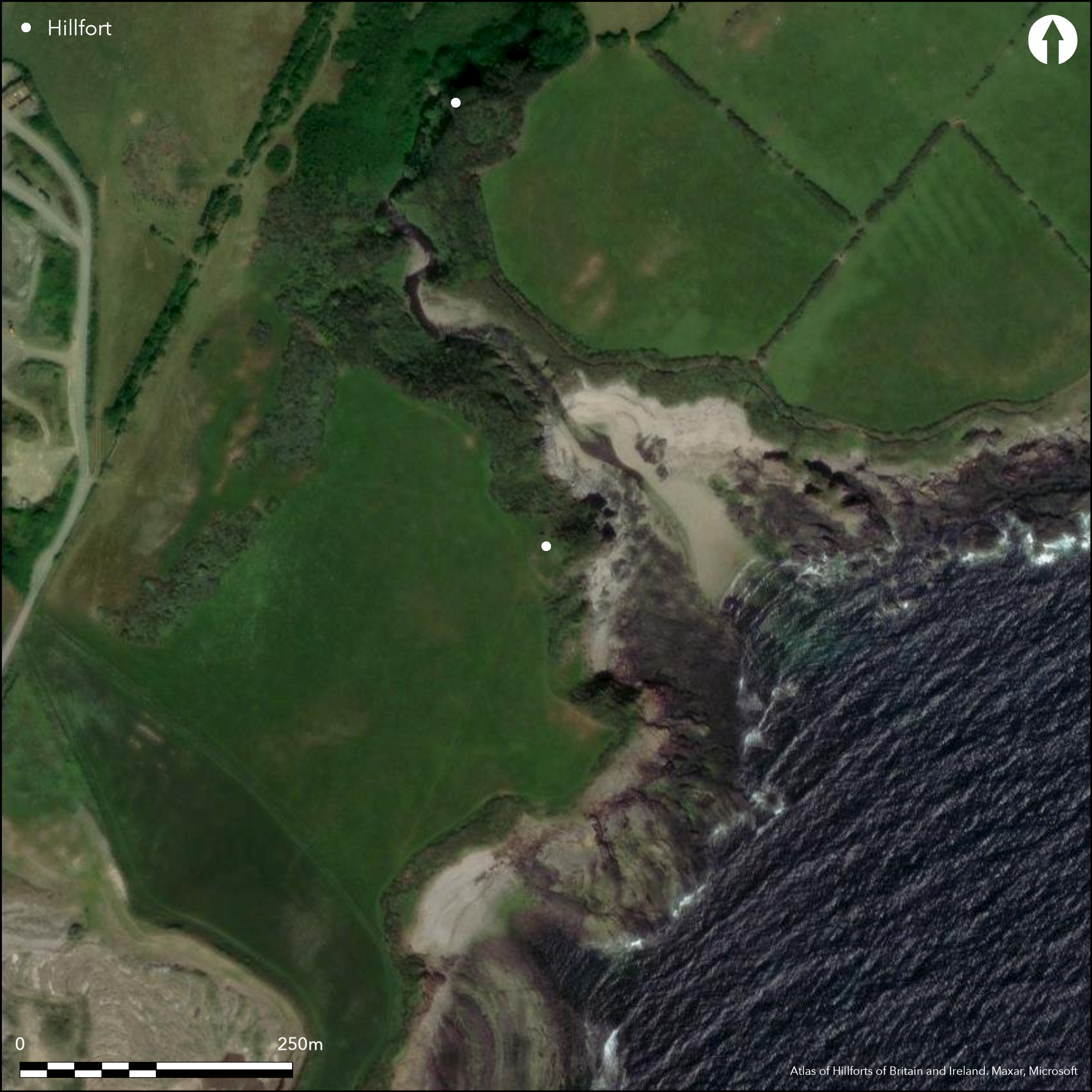
Satellite Imagery
Satellite Imagery
HER: Isle of Man 74 (None)
NMR: SC26NE 3 (29926)
SM: None
NGR: SC29776925
X: 229770 Y: 469250 (OSGB36)
Small coastal promontory fort located above mouth of stream on S side of Santon River on small, rocky and sheer headland. Roughly triangular shape, with precipitous cliffs to on E and SE and steep and wide river-course on N. Erosion has probably taken part of the site and present area not defined, but estimated less than 0.5ha. Neck of promontory on W cut off by substantial bank and rock-cut ditch, sectioned by Gelling's excavation on site of 1957 who found earthen bank faced with dry-stone revetment front and rear, 0.5m and 0.6m high respectively. Bank now c. 7m wide and c. 2.2m high externally and to 1.4m internally. Ditch has now virtually gone and only fragments remain on S and NW to c. 6m wide and c. 1m deep. Possible bank replacement of earlier phase. Gelling also excavated rectangular longhouse, 9.8m long by 3.9m to 4.6m wide, with benches cut into bedrock on long sides and part on N end. Timbers would have supported roof and elongated hearth in centre. Possible 5th or 6th century AD, or indeed, more probably, 11th to 13th century date. The only Isle of Man promontory fort where pottery found. Rampart of probable Iron Age date (or less than first century AD), Gelling considering this to be a replacement of an earlier phase, with medieval longhouse occupation on ruinous earlier defences. Site now grass covered with gorse, with longhouse remains now low spread bank. On 1st Ed. OS map (1866-9).
Citizen Science: ✗
Reliability of Data: Confirmed
Reliability of Interpretation: Confirmed
X: -512559 Y: 7187397 (EPSG: 3857)
Longitude: -4.6043939129388285 Latitude: 54.09093291576163 (EPSG:4326)
Country: Isle of Man
Current County or Unitary Authority: Middle
Historic County: Middle
Current Parish/Community/Council/Townland: Malew
Site subject to erosion. Longhouse remains now low spread bank and ditch in part only.
| Extant | ✓ |
| Cropmark | ✗ |
| Likely Destroyed | ✓ |
Site now grass covered with gorse, with longhouse remains now low spread bank.
| Woodland | ✗ |
| Commercial Forestry Plantation | ✗ |
| Parkland | ✗ |
| Pasture (Grazing) | ✗ |
| Arable | ✗ |
| Scrub/Bracken | ✓ |
| Bare Outcrop | ✗ |
| Heather/Moorland | ✗ |
| Heath | ✗ |
| Built-up | ✗ |
| Coastal Grassland | ✓ |
| Other | ✗ |
Small coastal promontory fort located above mouth of stream on S side of Santon River on small, rocky and sheer headland. Roughly triangular shape, with precipitous cliffs to on E and SE and steep and wide river-course on N.
| Contour Fort | ✗ |
| Partial Contour Fort | ✗ |
| Promontory Fort | ✓ |
| Hillslope Fort | ✗ |
| Level Terrain Fort | ✗ |
| Marsh Fort | ✗ |
| Multiple Enclosure Fort | ✗ |
| Hilltop | ✗ |
| Coastal Promontory | ✓ |
| Inland Promontory | ✗ |
| Valley Bottom | ✗ |
| Knoll/Hillock/Outcrop | ✗ |
| Ridge | ✗ |
| Cliff/Plateau-edge/Scarp | ✗ |
| Hillslope | ✗ |
| Lowland | ✗ |
| Spur | ✗ |
Dominant Topographic Feature: Rocky headland
| North | ✗ |
| Northeast | ✗ |
| East | ✗ |
| Southeast | ✓ |
| South | ✗ |
| Southwest | ✗ |
| West | ✗ |
| Northwest | ✗ |
| Level | ✗ |
Altitude: 15.0m
N/A
Rampart of probable Iron Age date (or less than 1st century AD), Gelling considering this to be a replacement of an earlier phase. Medieval longhouse occupation on ruinous earlier defences, of possible 5th or 6th century AD, or indeed 11th to 13th century date.
Reliability: C - Low
| Pre 1200BC | ✗ |
| 1200BC - 800BC | ✗ |
| 800BC - 400BC | ✗ |
| 400BC - AD50 | ✓ |
| AD50 - AD400 | ✗ |
| AD400 - AD 800 | ✓ |
| Post AD800 | ✗ |
| Unknown | ✗ |
| Pre Hillfort: | None |
| Post Hillfort: | None |
On 1st Ed. OS map (1866-9). Excavation P.S. Gelling 1957. Field survey J. Woodcock 1999. Field visits University of Liverpool 2010, 2011.
| Excavation (1957): | P.S. Gelling. |
| Other (1999): | Field survey J. Woodcock. |
| Other (2015): | Visited by Hillfort Study Group |
| 1st Identified Map Depiction (None): | OS map. |
| Other (None): | Field visits University of Liverpool. |
Rectangular medieval longhouse excavated by P.S. Gelling 1957, still visible as low spread bank.Pottery from excavation.
None
| None | ✓ |
| Spring | ✗ |
| Stream | ✗ |
| Pool | ✗ |
| Flush | ✗ |
| Well | ✗ |
| Other | ✗ |
Remains of medieval longhouse visible as low spread bank.
| No Known Features | ✗ |
| Round Stone Structures | ✗ |
| Rectangular Stone Structures | ✓ |
| Curvilinear Platforms | ✗ |
| Other Roundhouse Evidence | ✗ |
| Pits | ✗ |
| Quarry Hollows | ✗ |
| Other | ✗ |
Rectangular medieval longhouse.
| No Known Excavation | ✗ |
| Pits | ✗ |
| Postholes | ✗ |
| Roundhouses | ✗ |
| Rectangular Structures | ✓ |
| Roads/Tracks | ✗ |
| Quarry Hollows | ✗ |
| Other | ✗ |
| Nothing Found | ✗ |
None
| No Known Geophysics | ✓ |
| Pits | ✗ |
| Roundhouses | ✗ |
| Rectangular Structures | ✗ |
| Roads/Tracks | ✗ |
| Quarry Hollows | ✗ |
| Other | ✗ |
| Nothing Found | ✗ |
None
| No Known Finds | ✗ |
| Pottery | ✓ |
| Metal | ✗ |
| Metalworking | ✗ |
| Human Bones | ✗ |
| Animal Bones | ✗ |
| Lithics | ✗ |
| Environmental | ✗ |
| Other | ✗ |
None
| APs Not Checked | ✓ |
| None | ✗ |
| Roundhouses | ✗ |
| Rectangular Structures | ✗ |
| Pits | ✗ |
| Postholes | ✗ |
| Roads/Tracks | ✗ |
| Other | ✗ |
Possible gap on NW.
| 1: | None |
| 2: | Possible. |
Guard Chambers: ✗
Chevaux de Frise: ✗
| 1. Simple Gap (North west): | Possible. |
Neck of promontory on W cut off by substantial bank and rock-cut ditch, sectioned by Gelling's excavation on site of 1957 who found earthen bank faced with dry-stone revetment front and rear, 0.5m and 0.6m respectively. Bank now c. 7m wide and c. 2.2m high externally and to 1.4m internally. Ditch has now virtually gone and only fragments remain on S and NW to c. 6m wide and c. 1m deep. He thought bank replacement of earlier phase.
| Area 1: | Noneha. |
| Total: | Noneha. |
Total Footprint Area: Noneha.
None
| ✓ | Area not defined, but estimated less than 0.5ha. Rampart of probable Iron Age date (or less than first century AD), Gelling considering this to be a replacement of an earlier phase. Medieval longhouse occupation on ruinous earlier defences. |
| ✗ | None |
| NE Quadrant: | 0 |
| SE Quadrant: | 0 |
| SW Quadrant: | 1 |
| NW Quadrant: | 1 |
| Total: | 1 |
| Partial Univallate | ✓ |
| Univallate | ✗ |
| Partial Bivallate | ✗ |
| Bivallate | ✗ |
| Partial Multivallate | ✗ |
| Multivallate | ✗ |
| Unknown | ✗ |
| Partial Univallate | ✗ |
| Univallate | ✗ |
| Partial Bivallate | ✗ |
| Bivallate | ✗ |
| Partial Multivallate | ✗ |
| Multivallate | ✗ |
None
| None | ✗ |
| Earthen Bank | ✓ |
| Stone Wall | ✗ |
| Rubble | ✗ |
| Wall-walk | ✗ |
| Evidence of Timber | ✗ |
| Vitrification | ✗ |
| Other Burning | ✗ |
| Palisade | ✗ |
| Counter Scarp Bank | ✗ |
| Berm | ✗ |
| Unfinished | ✗ |
| Other | ✗ |
Neck of promontory on W cut off by substantial bank and rock-cut ditch, sectioned by Gelling's excavation on site of 1957 who found earthen bank faced with drystone revetment front and rear.
| None | ✗ |
| Earthen Bank | ✓ |
| Stone Wall | ✓ |
| Murus Duplex | ✗ |
| Timber-framed | ✗ |
| Timber-laced | ✗ |
| Vitrification | ✗ |
| Other Burning | ✗ |
| Palisade | ✗ |
| Counter Scarp Bank | ✗ |
| Berm | ✗ |
| Unfinished | ✗ |
| No Known Excavation | ✗ |
| Other | ✗ |
| ✗ | None |
| ✓ | Ditch only visible in part. |
Number of Ditches: 1
| ✗ | None |
Bersu, G. 1949. A promontory fort on the shore of Ramsey Bay, Isle of Man, Antiq J, XXIX, 62-79.
Gelling, P.S. 1959. Excavation of a promontory fort at Cas ny Hawin, Malew, Isle of Man, Proc Isle of Man Nat Hist Antiq Soc, 6.1, 28-38.
Atlas of Hillforts:
Wikidata:
This work is licensed under CC BY-SA 4.0

 and should be cited as:
Lock, Gary and Ralston, Ian. 2024. Atlas of Hillforts of Britain and Ireland. Available at: https://hillforts.arch.ox.ac.uk
Document Version 1.1