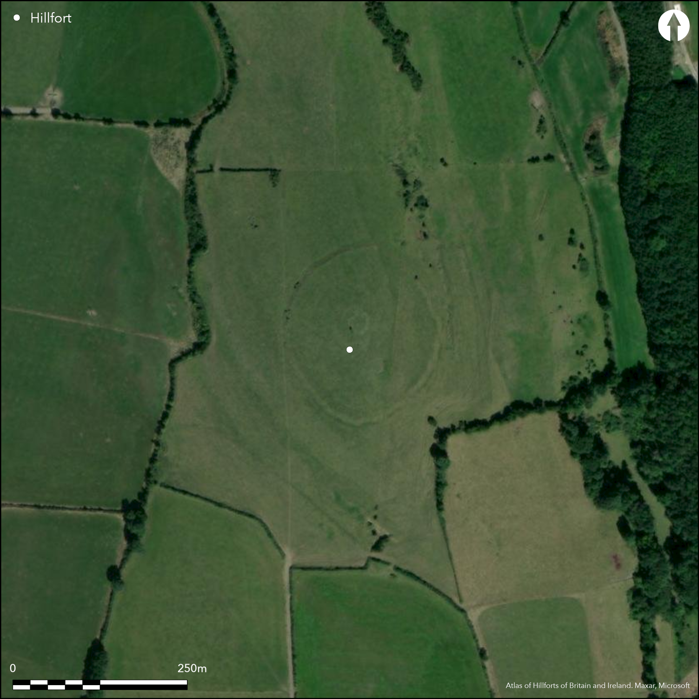
Satellite Imagery
Satellite Imagery
HER: Archaeological Survey of Ireland SMR Database KK020-018002 (None)
NMR: KK 020 (None)
SM: None
NGR: None
X: 658829 Y: 656234 (IRENET95)
The partial contour fort surrounds the low-domed summit of Freestone Hill, following the 130m contour at the E, S and W. The hilltop is located at the S foothills of the Castlecomer Hills, overlooking Kilkenny town and a N - S running natural routeway through a gap in the Slieveardagh Hills and Castlecomer Hills. The hillfort comprises a single low rising bank, maximum 1m in height, with external ditch. It has a total site foot print of 1.5ha. The interior rises towards a flat centre where the partial remains of a circular wall 18m in diameter was surrounded by a larger 37m x 30m oval enclosure (Raftery 1969, 6). Underneath these enclosures, the remains of a cairn was excavated. Raftery (1969, 7) suggests that this was later destroyed by the Iron Age occupants of the site. Excavations were undertaken by Bersu in 1948 - 1949 and published by Raftery in 1969. î Floinn (2000) reanalyzed a number of the artifacts from the site in the late 1990's and has dated them and the site to the Late Bronze Age. First map depiction in first edition Ordnance Survey mapping. More detailed earthwork survey in second edition Ordnance Survey mapping. Excavations by Bersu in 1948 - 1949, published by Raftery (1969). Unpublished geophysical survey of interior by Target geophysical company. Recent unpublished geophysical survey undertaken (2014) by the Roman-Germanic Commission (RGK) of the Deutsches Arch_ologisches Institut and the LIARI project of the Irish Discovery Programme.
Citizen Science: ✗
Reliability of Data: Confirmed
Reliability of Interpretation: Confirmed
X: -793765 Y: 6919271 (EPSG: 3857)
Longitude: -7.130516087017199 Latitude: 52.65410411298543 (EPSG:4326)
Country: Republic of Ireland
Current County or Unitary Authority: Kilkenny
Historic County: Kilkenny
Current Parish/Community/Council/Townland: Freestone Hill
None
| Extant | ✓ |
| Cropmark | ✗ |
| Likely Destroyed | ✗ |
None
| Woodland | ✗ |
| Commercial Forestry Plantation | ✗ |
| Parkland | ✗ |
| Pasture (Grazing) | ✓ |
| Arable | ✗ |
| Scrub/Bracken | ✗ |
| Bare Outcrop | ✗ |
| Heather/Moorland | ✗ |
| Heath | ✗ |
| Built-up | ✗ |
| Coastal Grassland | ✗ |
| Other | ✗ |
Partial contour fort surrounding the low-domed summit of Freestone Hill, following the 130m contour at the E, S and W. The hilltop is located at the S foothills of the Castlecomer Hills, overlooking Kilkenny town and a N - S running natural routeway through a gap in the Slieveardagh Hills and Castlecomer Hills.
| Contour Fort | ✗ |
| Partial Contour Fort | ✓ |
| Promontory Fort | ✗ |
| Hillslope Fort | ✗ |
| Level Terrain Fort | ✗ |
| Marsh Fort | ✗ |
| Multiple Enclosure Fort | ✗ |
| Hilltop | ✓ |
| Coastal Promontory | ✗ |
| Inland Promontory | ✗ |
| Valley Bottom | ✗ |
| Knoll/Hillock/Outcrop | ✗ |
| Ridge | ✗ |
| Cliff/Plateau-edge/Scarp | ✗ |
| Hillslope | ✗ |
| Lowland | ✗ |
| Spur | ✗ |
Dominant Topographic Feature: Hilltop.
| North | ✗ |
| Northeast | ✗ |
| East | ✗ |
| Southeast | ✗ |
| South | ✗ |
| Southwest | ✗ |
| West | ✗ |
| Northwest | ✗ |
| Level | ✓ |
Altitude: 134.0m
N/A
The univallate hillfort at Freestone Hill was originally dated to the fourth century AD due to the recovery of Roman artifacts (Raftery 1969; Bateson 1973, 45). Although the assemblage is clearly representative of a strong Iron Age presence, coarse-ware pottery discovered underneath the hillfort bank, within the ditch fill and within occupation areas inside the hillfort (Raftery 1969, 91) implies that the original construction and occupation of the hillfort dates to the Late Bronze Age. Raftery (1976, 58 _ 59) later conceded that Freestone Hill was probably constructed in the Late Bronze Age. î Floinn (2000) suggests that the ceramic assemblage, as well as other artifacts, date both the hillfort and the enclosure at its centre to the Late Bronze Age. In particular, the composition of three blue glass beads found within habitation layers on the site are likely to be Late Bronze Age (Henderson 1988, 442). A fourth bead is closely paralleled with Later Bronze Age beads on the continent and from Rathgall hillfort Co. Wicklow (î Floinn 2000, 17). A single radiocarbon date (810 _ 550 BC) obtained from charcoal recovered in an occupation layer confirms Late Bronze Age/ Early Iron Age occupation (Raftery, 1995; Waddell 1998, 270).
Reliability: B - Medium
| Pre 1200BC | ✗ |
| 1200BC - 800BC | ✓ |
| 800BC - 400BC | ✓ |
| 400BC - AD50 | ✗ |
| AD50 - AD400 | ✗ |
| AD400 - AD 800 | ✗ |
| Post AD800 | ✗ |
| Unknown | ✗ |
| Pre Hillfort: | None |
| Post Hillfort: | None |
| Artefactual: | Late Bronze Age glass beads, Late Bronze Age coarse-ware pottery |
| C14: | 810 – 550 BC (Raftery, 1995; Waddell 1998, 270) |
First map depiction in first edition Ordnance Survey mapping. More detailed earthwork survey in second edition Ordnance Survey mapping. Excavations by Bersu in 1948 - 1949, published by Raftery (1969). Recent unpublished geophysical survey undertaken (2014) by the Roman-Germanic Commission (RGK) of the Deutsches Arch_ologisches Institut and the LIARI project of the Irish Discovery Programme.
| 1st Identified Map Depiction (1842): | First edition 6 inch Ordnance Survey mapping. |
| Earthwork Survey (1906): | Second edition 25 inch Ordnance Survey mapping. |
| Geophysical Survey (2014): | Unpublished geophysical survey of interior by Target geophysical company. |
| Geophysical Survey (2014): | Undertaken by the Roman-Germanic Commission (RGK) of the Deutsches Archäologisches Institut and the LIARI project of the Irish Discovery Programme. Survey investigated the surrounding area of the hillfort. |
| Excavation (None): | Bersu |
Circular cairn at center of the hillfort, approximately 23m in diameter was levelled by later occupation (Raftery 1969, 7). Three inhumations and thirteen cremations were associated with the cairn. The cairn was truncated by a circular wall, 18m in diameter, and a larger (37m x 30m) oval enclosure (Raftery 1969, 6). Two excavated shallow depressions within the larger enclosure at the centre of the hillfort revealed spreads of artifacts and Çdark soil, and may be considered occupation areas. Four similar features within the hilflort remain unexcavated (Raftery 1969, 41). Recent unpublished geophysical survey undertaken (2014) by the Roman-Germanic Commission (RGK) of the Deutsches Arch_ologisches Institut and the LIARI project of the Irish Discovery Programme. This survey covered a large area surrounding the hilltop.
None
| None | ✓ |
| Spring | ✗ |
| Stream | ✗ |
| Pool | ✗ |
| Flush | ✗ |
| Well | ✗ |
| Other | ✗ |
A number of curvilinear platforms are visible.
| No Known Features | ✗ |
| Round Stone Structures | ✗ |
| Rectangular Stone Structures | ✗ |
| Curvilinear Platforms | ✓ |
| Other Roundhouse Evidence | ✗ |
| Pits | ✗ |
| Quarry Hollows | ✗ |
| Other | ✗ |
Two enclosures, circular platforms and a cairn were excavated.
| No Known Excavation | ✗ |
| Pits | ✗ |
| Postholes | ✗ |
| Roundhouses | ✗ |
| Rectangular Structures | ✗ |
| Roads/Tracks | ✗ |
| Quarry Hollows | ✗ |
| Other | ✓ |
| Nothing Found | ✗ |
Unpublished geophysical survey of interior by Target geophysical company. Recent unpublished geophysical survey undertaken (2014) by the Roman-Germanic Commission (RGK) of the Deutsches Arch_ologisches Institut and the LIARI project of the Irish Discovery Programme.
| No Known Geophysics | ✗ |
| Pits | ✗ |
| Roundhouses | ✗ |
| Rectangular Structures | ✗ |
| Roads/Tracks | ✗ |
| Quarry Hollows | ✗ |
| Other | ✓ |
| Nothing Found | ✗ |
Thirteen cremations, three inhumations, at least five food vessels and a large quantity of worked flint are associated with earlier activity at the site. Antler picks, coarse-ware pottery and glass beads can be associated with the construction of the hillfort in the Late Bronze Age. Bronze bracelets of Romano-British type, two Roman toilet implements and a Bronze mount and copper coin dating to AD 337 _ 340 to Constantine the Great's rule (Bateson 1973, 45) attest to Iron Age re-occupation of the site.
| No Known Finds | ✗ |
| Pottery | ✓ |
| Metal | ✓ |
| Metalworking | ✗ |
| Human Bones | ✗ |
| Animal Bones | ✓ |
| Lithics | ✓ |
| Environmental | ✗ |
| Other | ✗ |
Circular platforms within the interior may relate to occupation features.
| APs Not Checked | ✗ |
| None | ✗ |
| Roundhouses | ✗ |
| Rectangular Structures | ✗ |
| Pits | ✗ |
| Postholes | ✗ |
| Roads/Tracks | ✗ |
| Other | ✓ |
Possible original entrance in the E, defined by a simple gap in the bank.
| 1: | None |
| 2: | None |
Guard Chambers: ✗
Chevaux de Frise: ✗
| 1. Simple Gap (East): | None |
Excavation revealed that the enclosing elements comprised a bank with an external, rock-cut ditch. The profile of the ditch is irregular, varying from flat bottomed to V-shaped (although there is a tendency towards the flat bottomed shape), due most likely, to the builders following natural fissures wherever possible (Raftery 1969, 33). The ditch varies in width and depth, 1.3m _ 2.5m in width (averages 2m) and 0.75m _ 2m in depth (Raftery 1969, 33). The bank is composed of stone and gravel, varying from 2.5m _ 4m wide at its base, rising 0.5m _ 1m above the old ground surface (Raftery 1969, 34). Traces of large blocks may suggest some form of stone facing (Raftery 1969, 34). A potential post-hole was identified on the crest of the bank, however, Raftery (1969, 34 _ 35) suggests this is unlikely to relate to a timber palisade.
| Area 1: | 1.37ha. |
| Total: | 1.37ha. |
Total Footprint Area: 1.52ha.
None
| ✗ | None |
| ✓ | None |
| NE Quadrant: | 1 |
| SE Quadrant: | 1 |
| SW Quadrant: | 1 |
| NW Quadrant: | 1 |
| Total: | 1 |
| Partial Univallate | ✗ |
| Univallate | ✓ |
| Partial Bivallate | ✗ |
| Bivallate | ✗ |
| Partial Multivallate | ✗ |
| Multivallate | ✗ |
| Unknown | ✗ |
| Partial Univallate | ✗ |
| Univallate | ✗ |
| Partial Bivallate | ✗ |
| Bivallate | ✗ |
| Partial Multivallate | ✗ |
| Multivallate | ✗ |
None
| None | ✗ |
| Earthen Bank | ✓ |
| Stone Wall | ✗ |
| Rubble | ✗ |
| Wall-walk | ✗ |
| Evidence of Timber | ✗ |
| Vitrification | ✗ |
| Other Burning | ✗ |
| Palisade | ✗ |
| Counter Scarp Bank | ✗ |
| Berm | ✗ |
| Unfinished | ✗ |
| Other | ✗ |
The bank consists of a mix of stone and gravel, accompanied by an external ditch.
| None | ✗ |
| Earthen Bank | ✓ |
| Stone Wall | ✗ |
| Murus Duplex | ✗ |
| Timber-framed | ✗ |
| Timber-laced | ✗ |
| Vitrification | ✗ |
| Other Burning | ✗ |
| Palisade | ✗ |
| Counter Scarp Bank | ✗ |
| Berm | ✗ |
| Unfinished | ✗ |
| No Known Excavation | ✗ |
| Other | ✓ |
| ✗ | None |
| ✓ | None |
Number of Ditches: 1
| ✗ | None. |
Bateson, D. 1973. Roman material from Ireland: a reconsideration. Proceedings of the Royal Irish Academy, 73C, 21-97.
Henderson, J. 1988. Glass production and Bronze Age Europe. Antiquity (62). 435-451.
Ó Floinn, R. 2000. Freestone Hill, Co. Kilkenny: a re-assessment. In Smyth, A. (ed. ) Seanachas: Studies in Early and Medieval Irish Archaeology, History and Literature in Honor of Francis J. Byrne. Four Courts Press, Dublin. 12-29.
Raftery, B. 1969. Freestone Hill, Co. Kilkenny: an Iron Age and Bronze Age cairn: excavation Gerhard Bersu. Proceedings of the Royal Irish Academy. 68(C) 1-108.
Raftery, B. 1976. Rathgall and Irish Hillfort Problems. In Harding, D. (ed.) Hillforts: Later Prehistoric Earthworks of Britain and Ireland, Academic Press, London. 339-357.
Raftery, B. 1995. The conundrum of the Irish Iron Age pottery. In Raftery, B., Megaw, V. and Rigby, V. (eds) Sites and Sights of the Iron Age. Esseys on Fieldwork and Museum Research presented to Ian Matheson Stead. Oxbow, Oxford, 149-156.
Waddell, J. 1998. The Prehistoric Archaeology of Ireland. Wordwell, Dublin.
Atlas of Hillforts:
Wikidata:
This work is licensed under CC BY-SA 4.0

 and should be cited as:
Lock, Gary and Ralston, Ian. 2024. Atlas of Hillforts of Britain and Ireland. Available at: https://hillforts.arch.ox.ac.uk
Document Version 1.1