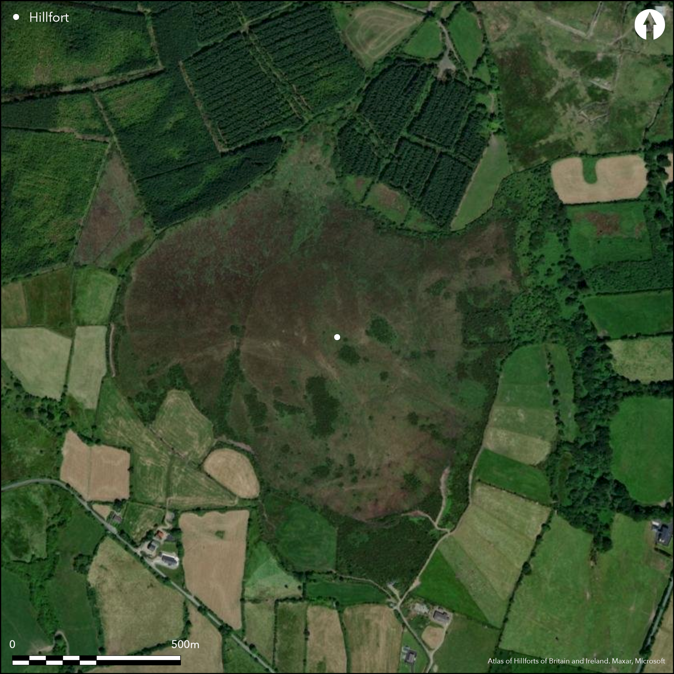
Satellite Imagery
Satellite Imagery
HER: Archaeological Survey of Ireland SMR Database LI028-085 (None)
NMR: LI 028 (None)
SM: None
NGR: None
X: 525748 Y: 639522 (IRENET95)
Widely spaced multiple enclosure in commanding position on Ballylin Hill. The hilltop is positioned on partial spur in a N - S running escarpment. This provides Ballylin with panoramic views of the Limerick plains and Shannon estury to the N, E and S. The hillfort has a total site footprint of approximately 20.5ha. Bivallate for its entire circuit with a slight in-turned entrance to the SE. There are two other breaks in the inner enclosing elements which may be original. There are no obvious corresponding breaks in the outer enclosing features. There is no evidence for any internal features on the surface. Geophysical survey has identified a cluster of possible pit features within the inner enclosing elements at the E. The enclosing elements survive well throughout much of its length, however, they are heavily overgrown in places and are under approximately 0.3m of peat. The entire hillfort is under a heavy blanket of heather and patches of scrub. First recorded by John Danaher during aerial photography survey in 1981. Geophysical survey by O'Driscoll (2012). Targeted excavation by O'Brien (2012). Earthwork survey by Cody (1981). Late Bronze Age dates from basal fill of inner and outer enclosing elements.
Citizen Science: ✗
Reliability of Data: Confirmed
Reliability of Interpretation: Confirmed
X: -1012300 Y: 6891413 (EPSG: 3857)
Longitude: -9.093648928738794 Latitude: 52.502031096129336 (EPSG:4326)
Country: Republic of Ireland
Current County or Unitary Authority: Limerick
Historic County: Limerick
Current Parish/Community/Council/Townland: Ballylin
Heavily overgrown. The outer enclosing feature is partially destroyed at the NE.
| Extant | ✓ |
| Cropmark | ✗ |
| Likely Destroyed | ✓ |
Approximately 0.3m of peat deposit.
| Woodland | ✗ |
| Commercial Forestry Plantation | ✗ |
| Parkland | ✗ |
| Pasture (Grazing) | ✗ |
| Arable | ✗ |
| Scrub/Bracken | ✓ |
| Bare Outcrop | ✗ |
| Heather/Moorland | ✓ |
| Heath | ✗ |
| Built-up | ✗ |
| Coastal Grassland | ✗ |
| Other | ✗ |
Widely spaced multiple enclosure in commanding position surrounding the somewhat flat summit of Ballylin Hill. The hilltop acts as a small spur in the N - S running escarpment, N of the Mullaghareirk Mountains. This provides Ballylin Hill with exceptional views of the Limerick plains to the N, E and S.
| Contour Fort | ✓ |
| Partial Contour Fort | ✗ |
| Promontory Fort | ✗ |
| Hillslope Fort | ✗ |
| Level Terrain Fort | ✗ |
| Marsh Fort | ✗ |
| Multiple Enclosure Fort | ✓ |
| Hilltop | ✓ |
| Coastal Promontory | ✗ |
| Inland Promontory | ✗ |
| Valley Bottom | ✗ |
| Knoll/Hillock/Outcrop | ✗ |
| Ridge | ✗ |
| Cliff/Plateau-edge/Scarp | ✗ |
| Hillslope | ✗ |
| Lowland | ✗ |
| Spur | ✓ |
Dominant Topographic Feature: Hilltop/spur,
| North | ✗ |
| Northeast | ✗ |
| East | ✗ |
| Southeast | ✗ |
| South | ✗ |
| Southwest | ✗ |
| West | ✗ |
| Northwest | ✗ |
| Level | ✓ |
Altitude: 243.0m
N/A
Late Bronze Age dates from basal deposits of ditch fill in both inner and outer enclosing elements.
Reliability: A - High
| Pre 1200BC | ✗ |
| 1200BC - 800BC | ✓ |
| 800BC - 400BC | ✗ |
| 400BC - AD50 | ✗ |
| AD50 - AD400 | ✗ |
| AD400 - AD 800 | ✗ |
| Post AD800 | ✗ |
| Unknown | ✗ |
| Pre Hillfort: | None |
| Post Hillfort: | None |
| C14: | Basal deposits of ditch fill in inner and outer enclosing elements. |
First recorded by John Danaher during aerial photography survey in 1981. Geophysical survey by O'Driscoll (2012). Targeted excavation by O'Brien (2012). Earthwork survey by Cody (1981).
| Earthwork Survey (1981): | Cody (1981) |
| Other (1981): | First recorded by John Danaher during aerial photography survey. |
| Geophysical Survey (2012): | O'Driscoll |
| Excavation (2012): | O'Brien |
There are no apparent features visible on the surface. Geophysical survey has identified a cluster of possible pit features within the interior to the E. Possible mound approximately 70m to E of hillfort.
There are a number of small springs and pools within the interior of the hillfort.
| None | ✗ |
| Spring | ✓ |
| Stream | ✗ |
| Pool | ✓ |
| Flush | ✗ |
| Well | ✗ |
| Other | ✗ |
None
| No Known Features | ✓ |
| Round Stone Structures | ✗ |
| Rectangular Stone Structures | ✗ |
| Curvilinear Platforms | ✗ |
| Other Roundhouse Evidence | ✗ |
| Pits | ✗ |
| Quarry Hollows | ✗ |
| Other | ✗ |
None
| No Known Excavation | ✓ |
| Pits | ✗ |
| Postholes | ✗ |
| Roundhouses | ✗ |
| Rectangular Structures | ✗ |
| Roads/Tracks | ✗ |
| Quarry Hollows | ✗ |
| Other | ✗ |
| Nothing Found | ✗ |
A number of possible pit features on the E side of the interior.
| No Known Geophysics | ✗ |
| Pits | ✓ |
| Roundhouses | ✗ |
| Rectangular Structures | ✗ |
| Roads/Tracks | ✗ |
| Quarry Hollows | ✗ |
| Other | ✗ |
| Nothing Found | ✗ |
None
| No Known Finds | ✓ |
| Pottery | ✗ |
| Metal | ✗ |
| Metalworking | ✗ |
| Human Bones | ✗ |
| Animal Bones | ✗ |
| Lithics | ✗ |
| Environmental | ✗ |
| Other | ✗ |
NO APPARENT FEATURES
| APs Not Checked | ✗ |
| None | ✓ |
| Roundhouses | ✗ |
| Rectangular Structures | ✗ |
| Pits | ✗ |
| Postholes | ✗ |
| Roads/Tracks | ✗ |
| Other | ✗ |
There are three possible original entrances in the inner enclosure. The possible entrances to the SE and W comprise simple breaks in the bank with a causeway in the outer ditch. The excavated entrance at the NE was very slightly in-turned. In comprises a break in the bank and rock-cut ditch. Set just inside the ditch terminals are two large post-holes. The northernmost example was substantially bigger and produced a large number of packing stones. This may suggest that this post held a gate.
| 3: | The outer enclosing elements are slighter and more overgrown than the inner example. It is difficult to identify any entrances features. |
| 2: | None |
Guard Chambers: ✗
Chevaux de Frise: ✗
| 1. In-turned (North east): | Simple 8m break in inner enclosure. |
| 2. Simple Gap (South east): | Excavated entrance in inner enclosure. |
| 3. Simple Gap (West): | Simple 6m break in inner enclosure |
Circular area defined by two widely spaced, roughly concentric enclosing features separated 80 - 120m apart. Cody (1981) suggests that the inner example consists of an internal ditch (2.5m wide and 0.75m deep) and external bank (2.5m wide and 0.75m high). Excavation and LiDAR survey has revealed that the inner enclosing elements comprised an internal bank and external ditch with an external counterscarp. The outer enclosing elements also comprised an inner bank and external ditch and counterscarp.
| Area 1: | 7.2ha. |
| Area 2: | 20.0ha. |
| Total: | 20.0ha. |
Total Footprint Area: 20.5ha.
None
| ✗ | None |
| ✓ | None |
| NE Quadrant: | 2 |
| SE Quadrant: | 2 |
| SW Quadrant: | 2 |
| NW Quadrant: | 2 |
| Total: | 2 |
| Partial Univallate | ✗ |
| Univallate | ✗ |
| Partial Bivallate | ✗ |
| Bivallate | ✓ |
| Partial Multivallate | ✗ |
| Multivallate | ✗ |
| Unknown | ✗ |
| Partial Univallate | ✗ |
| Univallate | ✓ |
| Partial Bivallate | ✗ |
| Bivallate | ✗ |
| Partial Multivallate | ✗ |
| Multivallate | ✗ |
None
| None | ✗ |
| Earthen Bank | ✓ |
| Stone Wall | ✗ |
| Rubble | ✗ |
| Wall-walk | ✗ |
| Evidence of Timber | ✗ |
| Vitrification | ✗ |
| Other Burning | ✗ |
| Palisade | ✗ |
| Counter Scarp Bank | ✓ |
| Berm | ✗ |
| Unfinished | ✗ |
| Other | ✗ |
And ditch
| None | ✗ |
| Earthen Bank | ✓ |
| Stone Wall | ✗ |
| Murus Duplex | ✗ |
| Timber-framed | ✗ |
| Timber-laced | ✗ |
| Vitrification | ✗ |
| Other Burning | ✗ |
| Palisade | ✗ |
| Counter Scarp Bank | ✓ |
| Berm | ✗ |
| Unfinished | ✗ |
| No Known Excavation | ✗ |
| Other | ✓ |
| ✗ | None |
| ✓ | Inner ditch is rock-cut, approximately 3m wide and 0.8m deep. |
Number of Ditches: 2
| ✗ | None. |
Cody, E. 1981. A hillfort at Ballylin, county Limerick with a note on Mooghaun, county Clare. Journal of the Royal Society of Antiquaries of Ireland Vol.110, Elo Press Ltd. Dublin. 70-80.
O'Brien, W. 2012. Unpublished excavation report: Ballylin, Co. Limerick. UCC Cork, Dept of Archaeology.
O'Driscoll, J. 2012. Unpublished geophysical survey report: Ballylin, Co. Limerick. UCC Cork, Dept of Archaeology.
Atlas of Hillforts:
Wikidata:
This work is licensed under CC BY-SA 4.0

 and should be cited as:
Lock, Gary and Ralston, Ian. 2024. Atlas of Hillforts of Britain and Ireland. Available at: https://hillforts.arch.ox.ac.uk
Document Version 1.1