Satellite Imagery
Satellite Imagery
HER: Archaeological Survey of Ireland SMR Database ME016-054 (None)
NMR: ME 016 (None)
SM: None
NGR: None
X: 672245 Y: 776506 (IRENET95)
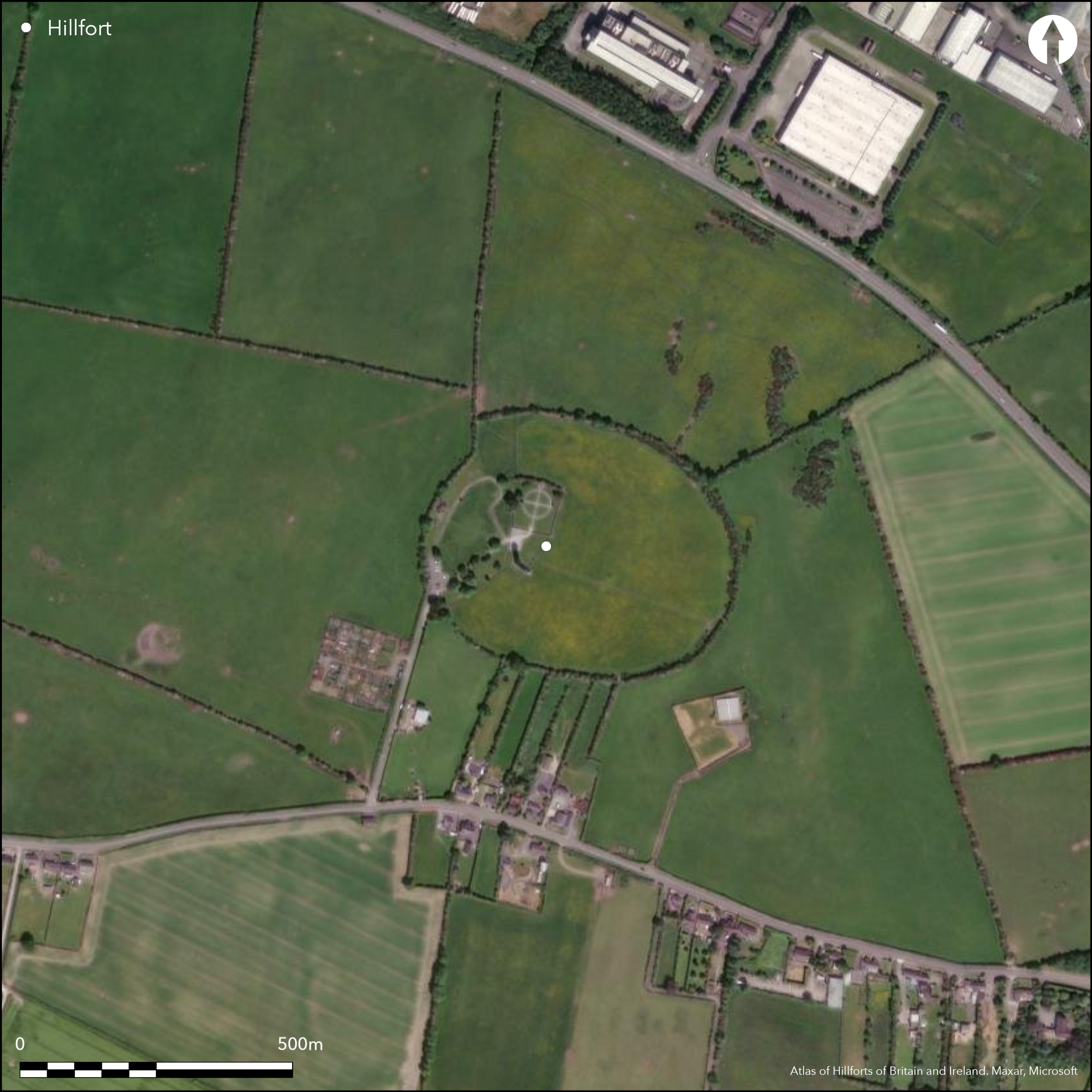
Near the town of Kells, an oval multiple enclosure of approximately 9.3ha total site foot print positioned on a low, conical hill overlooking the River Blackwater. Trivallate for the entire circuit with no recorded entrance features. No evidence for internal features contemporary with the construction or occupation of the hillfort. The outer ramparts are integrated into a field system. The inner and middle enclosing elements are heavily truncated by later agricultural activity. These are visible on aerial photography. Site under pasture. Limited excavations and monitoring by Neary (2003) and Wallace (2003) prior to development. These remain unpublished. Unpublished geophysical survey by The Discovery Programme in 2013. The area is mentioned in the Early Medieval text, ÇThe T_in', as being the site of a temporary camp (they spent a single night here) for queen Maeve's army, who were marching from Connaught to Cooley (Carr 1999, 101). First map depiction in first edition Ordnance Survey mapping shows the fort as an oval boundary. Also depicted as such in second edition Ordnance Survey maps.
Citizen Science: ✗
Reliability of Data: Confirmed
Reliability of Interpretation: Confirmed
X: -768669 Y: 7119788 (EPSG: 3857)
Longitude: -6.905068404664729 Latitude: 53.73319470990906 (EPSG:4326)
Country: Republic of Ireland
Current County or Unitary Authority: Meath
Historic County: Meath
Current Parish/Community/Council/Townland: Commons of Lloyds
Outer enclosing element largely extant. Inner and middle enclosing elements visible as vegetation marks on aerial photography. Deep ridge and furrow marks are visible traversing the interior in aerial photography.
| Extant | ✓ |
| Cropmark | ✗ |
| Likely Destroyed | ✓ |
Tower and telecommunications mast erected near summit of interior. Children's playground and parking facilities abutting E section of enclosing elements.
| Woodland | ✗ |
| Commercial Forestry Plantation | ✗ |
| Parkland | ✗ |
| Pasture (Grazing) | ✓ |
| Arable | ✗ |
| Scrub/Bracken | ✗ |
| Bare Outcrop | ✗ |
| Heather/Moorland | ✗ |
| Heath | ✗ |
| Built-up | ✓ |
| Coastal Grassland | ✗ |
| Other | ✗ |
Multiple enclosure positioned surrounding the summit of a low, conical hill overlooking the River Blackwater, which feeds the larger River Boyne. The hillfort follows the 120m contour at the N and partially at the E and W.
| Contour Fort | ✓ |
| Partial Contour Fort | ✗ |
| Promontory Fort | ✗ |
| Hillslope Fort | ✗ |
| Level Terrain Fort | ✗ |
| Marsh Fort | ✗ |
| Multiple Enclosure Fort | ✓ |
| Hilltop | ✓ |
| Coastal Promontory | ✗ |
| Inland Promontory | ✗ |
| Valley Bottom | ✗ |
| Knoll/Hillock/Outcrop | ✗ |
| Ridge | ✗ |
| Cliff/Plateau-edge/Scarp | ✗ |
| Hillslope | ✗ |
| Lowland | ✗ |
| Spur | ✗ |
Dominant Topographic Feature: Low conical hill.
| North | ✗ |
| Northeast | ✗ |
| East | ✗ |
| Southeast | ✗ |
| South | ✗ |
| Southwest | ✗ |
| West | ✗ |
| Northwest | ✗ |
| Level | ✓ |
Altitude: 129.0m
N/A
No dating evidence. Excavation prior to the laying of a telecommunications cable revealed cremated animal bone which returned a radiocarbon date of 1130 _ 910 Cal. BC (Neary 2003, 12).
Reliability: D - None
| Pre 1200BC | ✗ |
| 1200BC - 800BC | ✗ |
| 800BC - 400BC | ✗ |
| 400BC - AD50 | ✗ |
| AD50 - AD400 | ✗ |
| AD400 - AD 800 | ✗ |
| Post AD800 | ✗ |
| Unknown | ✓ |
| Pre Hillfort: | None |
| Post Hillfort: | Tower and telecommunications antennae at center of hillfort. A disused graveyard within the interior of the inner enclosing element to the N. |
First map depiction in first edition Ordnance Survey mapping on which the fort is apparent as an oval boundary. Also depicted as such in second edition Ordnance Survey maps. Unpublished excavation prior to cable laying for telecommunications antennae in 2003 by Wallace. Unpublished excavation prior to cable laying for telecommunications antennae in 2003 by Neary. Unpublished geophysical survey by Discovery Programme in 2013.
| 1st Identified Map Depiction (1842): | First edition Ordnance Survey 6 inch mapping. |
| Other (1906): | Second edition 25 inch Ordnance Survey mapping. |
| Excavation (2003): | Wallace |
| Excavation (2003): | Neary |
| Geophysical Survey (2013): | Discovery Programme |
Tower and telecommunications antennae at centre of hillfort. A disused graveyard within the interior of the inner enclosing element to the N. Carpark and children's playground to W. Aerial photography has revealed extensive ridge and furrow features traversing the hillfort. This activity has likely destroyed or masked features that may have been previously visible on the surface. Quarry hollow within interior to N depicted in first edition Ordnance Survey mapping. No evidence for any internal features on the surface that may be contemporary with the hillfort construction or occupation. Excavation prior to the laying of a telecommunications cable revealed creamated animal bone which returned a radiocarbon date of 1130 _ 910 Cal. BC (Neary 2003, 12).
None
| None | ✓ |
| Spring | ✗ |
| Stream | ✗ |
| Pool | ✗ |
| Flush | ✗ |
| Well | ✗ |
| Other | ✗ |
None
| No Known Features | ✗ |
| Round Stone Structures | ✗ |
| Rectangular Stone Structures | ✗ |
| Curvilinear Platforms | ✗ |
| Other Roundhouse Evidence | ✗ |
| Pits | ✗ |
| Quarry Hollows | ✓ |
| Other | ✗ |
Results unknown
| No Known Excavation | ✗ |
| Pits | ✗ |
| Postholes | ✗ |
| Roundhouses | ✗ |
| Rectangular Structures | ✗ |
| Roads/Tracks | ✗ |
| Quarry Hollows | ✗ |
| Other | ✓ |
| Nothing Found | ✗ |
None
| No Known Geophysics | ✓ |
| Pits | ✗ |
| Roundhouses | ✗ |
| Rectangular Structures | ✗ |
| Roads/Tracks | ✗ |
| Quarry Hollows | ✗ |
| Other | ✗ |
| Nothing Found | ✗ |
None
| No Known Finds | ✓ |
| Pottery | ✗ |
| Metal | ✗ |
| Metalworking | ✗ |
| Human Bones | ✗ |
| Animal Bones | ✗ |
| Lithics | ✗ |
| Environmental | ✗ |
| Other | ✗ |
NO APPARENT FEATURES
| APs Not Checked | ✗ |
| None | ✓ |
| Roundhouses | ✗ |
| Rectangular Structures | ✗ |
| Pits | ✗ |
| Postholes | ✗ |
| Roads/Tracks | ✗ |
| Other | ✗ |
No apparent break in any of the enclosing elements. A modern road runs through the bank at the SW.
| 0: | None |
| 2: | None |
Guard Chambers: ✗
Chevaux de Frise: ✗
Three banks surround the summit of Lloyd Hill. These are closely spaced at the SW and W, and become widely spaced to E, the enclosing elements being separated by a maximum of 80m. The outer bank survives as an oval field boundary surmounted by a later stone wall. The middle and inner enclosing features are visible as denuded and heavily damaged ditch features.
| Area 1: | 2.58ha. |
| Area 2: | 4.99ha. |
| Area 3: | 8.98ha. |
| Total: | 8.98ha. |
Total Footprint Area: 9.31ha.
None
| ✗ | None |
| ✓ | None |
| NE Quadrant: | 3 |
| SE Quadrant: | 3 |
| SW Quadrant: | 3 |
| NW Quadrant: | 3 |
| Total: | 3 |
| Partial Univallate | ✗ |
| Univallate | ✗ |
| Partial Bivallate | ✗ |
| Bivallate | ✗ |
| Partial Multivallate | ✗ |
| Multivallate | ✓ |
| Unknown | ✗ |
| Partial Univallate | ✗ |
| Univallate | ✓ |
| Partial Bivallate | ✗ |
| Bivallate | ✗ |
| Partial Multivallate | ✗ |
| Multivallate | ✗ |
The outer bank survives as an oval field boundary surmounted by a later stone wall.
| None | ✗ |
| Earthen Bank | ✓ |
| Stone Wall | ✗ |
| Rubble | ✗ |
| Wall-walk | ✗ |
| Evidence of Timber | ✗ |
| Vitrification | ✗ |
| Other Burning | ✗ |
| Palisade | ✗ |
| Counter Scarp Bank | ✗ |
| Berm | ✗ |
| Unfinished | ✗ |
| Other | ✗ |
None
| None | ✗ |
| Earthen Bank | ✗ |
| Stone Wall | ✗ |
| Murus Duplex | ✗ |
| Timber-framed | ✗ |
| Timber-laced | ✗ |
| Vitrification | ✗ |
| Other Burning | ✗ |
| Palisade | ✗ |
| Counter Scarp Bank | ✗ |
| Berm | ✗ |
| Unfinished | ✗ |
| No Known Excavation | ✓ |
| Other | ✗ |
| ✗ | None |
| ✓ | Heavily denuded by ploughing. |
Number of Ditches: 2
| ✗ | None. |
Carr, W. 1999. Lloyn, townland and commons. In L. McNiff (ed.), Studies in Local History: Meath. Costello Print, Meath. 99 - 110.
Neary, P. 2003. Unpublished Report on Archaeological Testing and Monitoring at Hill of Lloyn, Co. Meath. Patrick Neary Archaeological Consultant.
Wallace, A. 2003. Unpublished Report on Archaeological Testing at Commons of Lloyd, Kells, Co. Meath. Arch-Tech, Dublin.
Atlas of Hillforts:
Wikidata:
This work is licensed under CC BY-SA 4.0

 and should be cited as:
Lock, Gary and Ralston, Ian. 2024. Atlas of Hillforts of Britain and Ireland. Available at: https://hillforts.arch.ox.ac.uk
Document Version 1.1