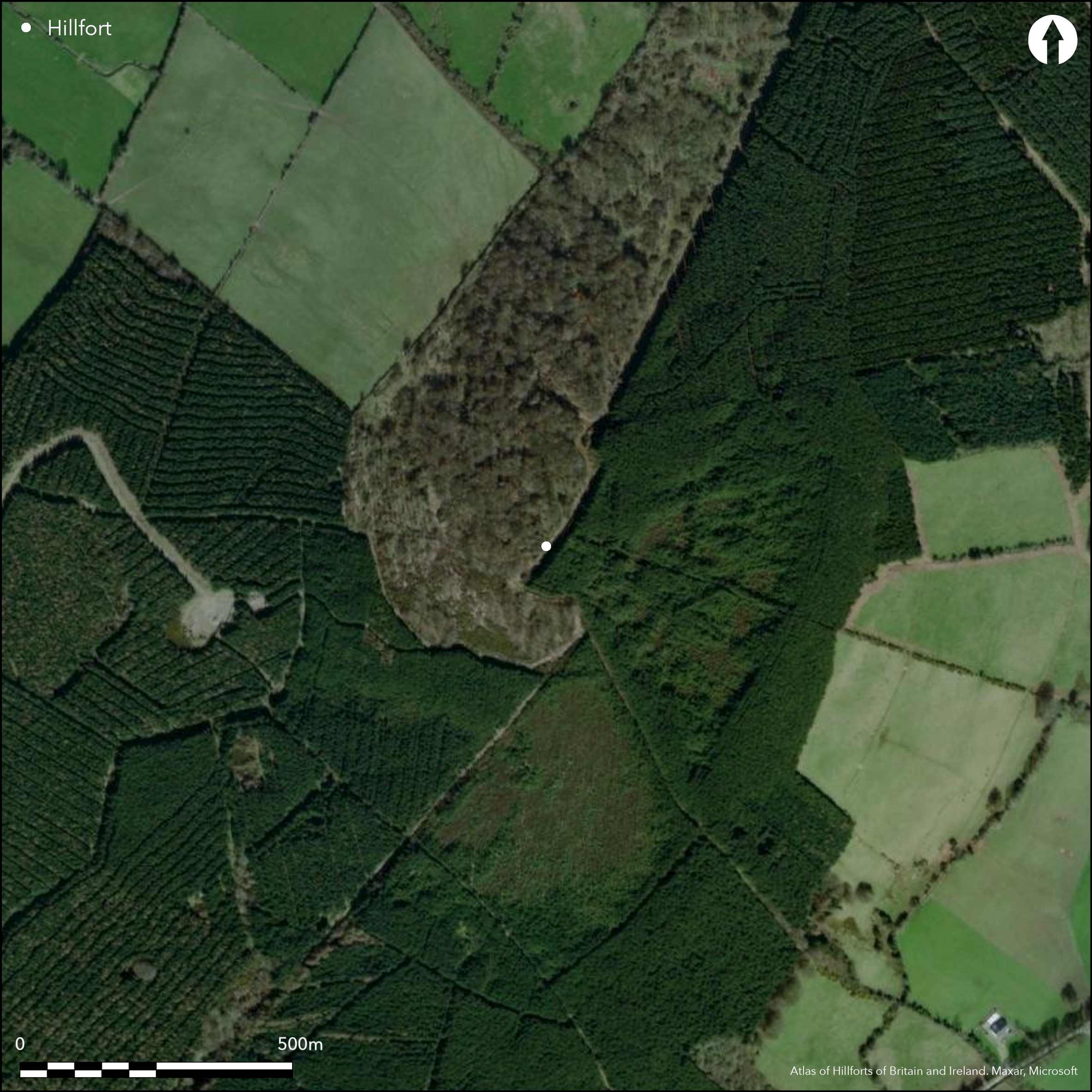
Satellite Imagery
Satellite Imagery
HER: Archaeological Survey of Ireland SMR Database OF036-062001 (None)
NMR: OF 036 (None)
SM: None
NGR: None
X: 620176 Y: 703573 (IRENET95)
Large multiple enclosure in commanding position surrounding summit of a steep hilltop, at E edge of Slieve Bloom Mountains. Site overlooks Camcor River to N and is positioned 1.9km to the NE of Ballymacmurragh hillfort. Most likely bivallate for the entire circuit. The total site foot print is approximately 12.2ha. There are no recorded breaks in the enclosing elements. No evidence for any internal features on the surface. Ramparts are largely obscured due to dense tree and scrub cover. Limited site description by Cooke (1875, 154). S section of inner enclosing elements recorded as a field boundary in second edition Ordnance Survey mapping.
Citizen Science: ✗
Reliability of Data: Confirmed
Reliability of Interpretation: Confirmed
X: -857032 Y: 6998250 (EPSG: 3857)
Longitude: -7.698853189075022 Latitude: 53.082379100839276 (EPSG:4326)
Country: Republic of Ireland; None
Current County or Unitary Authority: Offaly
Historic County: Offaly
Current Parish/Community/Council/Townland: Cumber Lower
Extensive tree cover has masked the entire monument. The enclosing elements of the hillfort are partially visible as vegetation marks.
| Extant | ✗ |
| Cropmark | ✗ |
| Likely Destroyed | ✓ |
None
| Woodland | ✓ |
| Commercial Forestry Plantation | ✓ |
| Parkland | ✗ |
| Pasture (Grazing) | ✗ |
| Arable | ✗ |
| Scrub/Bracken | ✗ |
| Bare Outcrop | ✗ |
| Heather/Moorland | ✗ |
| Heath | ✗ |
| Built-up | ✗ |
| Coastal Grassland | ✗ |
| Other | ✗ |
Multiple enclosure in commanding position surrounding summit of a steep hilltop, at E edge of Slieve Bloom Mountains. Site overlooks Camcor River to N. Ballymacmurragh hillfort 1.9km to SW.
| Contour Fort | ✓ |
| Partial Contour Fort | ✗ |
| Promontory Fort | ✗ |
| Hillslope Fort | ✗ |
| Level Terrain Fort | ✗ |
| Marsh Fort | ✗ |
| Multiple Enclosure Fort | ✓ |
| Hilltop | ✓ |
| Coastal Promontory | ✗ |
| Inland Promontory | ✗ |
| Valley Bottom | ✗ |
| Knoll/Hillock/Outcrop | ✗ |
| Ridge | ✗ |
| Cliff/Plateau-edge/Scarp | ✗ |
| Hillslope | ✗ |
| Lowland | ✗ |
| Spur | ✗ |
Dominant Topographic Feature: Steep hilltop.
| North | ✗ |
| Northeast | ✗ |
| East | ✗ |
| Southeast | ✗ |
| South | ✗ |
| Southwest | ✗ |
| West | ✗ |
| Northwest | ✗ |
| Level | ✓ |
Altitude: 337.0m
A number of field boundaries meet at the center of the hillfort. These form the townland boundaries of Cumber Lower, Cumber Upper, Forelacka and Lismoney.
Boundary Type: Parish/Townland
No dating evidence.
Reliability: D - None
| Pre 1200BC | ✗ |
| 1200BC - 800BC | ✗ |
| 800BC - 400BC | ✗ |
| 400BC - AD50 | ✗ |
| AD50 - AD400 | ✗ |
| AD400 - AD 800 | ✗ |
| Post AD800 | ✗ |
| Unknown | ✓ |
| Pre Hillfort: | None |
| Post Hillfort: | None |
Cooke (1875, 154) comments about the position of 'a large earthen rath or ring on Knock-na-man'. The southern portion of the inner enclosing element was recorded as a field boundary in second edition 25 inch Ordnance Survey mapping.
| 1st Identified Written Reference (1875): | Cooke (1875). |
| Other (1906): | 25 inch Ordnance Survey mapping. |
Antiquarian report that a figure of horseman carved in stone discovered within the possible hillfort (Cooke 1875, 154).
None
| None | ✓ |
| Spring | ✗ |
| Stream | ✗ |
| Pool | ✗ |
| Flush | ✗ |
| Well | ✗ |
| Other | ✗ |
None
| No Known Features | ✓ |
| Round Stone Structures | ✗ |
| Rectangular Stone Structures | ✗ |
| Curvilinear Platforms | ✗ |
| Other Roundhouse Evidence | ✗ |
| Pits | ✗ |
| Quarry Hollows | ✗ |
| Other | ✗ |
None
| No Known Excavation | ✓ |
| Pits | ✗ |
| Postholes | ✗ |
| Roundhouses | ✗ |
| Rectangular Structures | ✗ |
| Roads/Tracks | ✗ |
| Quarry Hollows | ✗ |
| Other | ✗ |
| Nothing Found | ✗ |
None
| No Known Geophysics | ✓ |
| Pits | ✗ |
| Roundhouses | ✗ |
| Rectangular Structures | ✗ |
| Roads/Tracks | ✗ |
| Quarry Hollows | ✗ |
| Other | ✗ |
| Nothing Found | ✗ |
Figure of horseman carved in stone (Cooke 1875, 154).
| No Known Finds | ✗ |
| Pottery | ✗ |
| Metal | ✗ |
| Metalworking | ✗ |
| Human Bones | ✗ |
| Animal Bones | ✗ |
| Lithics | ✗ |
| Environmental | ✗ |
| Other | ✓ |
NO APPARENT FEATURES
| APs Not Checked | ✗ |
| None | ✓ |
| Roundhouses | ✗ |
| Rectangular Structures | ✗ |
| Pits | ✗ |
| Postholes | ✗ |
| Roads/Tracks | ✗ |
| Other | ✗ |
No obvious entrance features recorded.
| 0: | None |
| 2: | None |
Guard Chambers: ✗
Chevaux de Frise: ✗
The enclosing elements have not been recorded and dense tree cover prevents attaining measurements from aerial photography. Cooke (1875, 154) suggests that the monument 'stands high, and is a very conspicuous object, surrounded by large stones which appear to have undergone the action of fire'. The southern portion of the inner enclosing element was recorded as a field boundary in second edition 25 inch Ordnance Survey mapping.
| Area 1: | 2.36ha. |
| Area 2: | 11.87ha. |
| Total: | 11.87ha. |
Total Footprint Area: 12.19ha.
None
| ✗ | None |
| ✓ | Difficult to ascertain, although the aerial photography suggests the enclosing elements likely formed complete circuits. |
| NE Quadrant: | 2 |
| SE Quadrant: | 2 |
| SW Quadrant: | 2 |
| NW Quadrant: | 2 |
| Total: | 2 |
| Partial Univallate | ✗ |
| Univallate | ✗ |
| Partial Bivallate | ✗ |
| Bivallate | ✓ |
| Partial Multivallate | ✗ |
| Multivallate | ✗ |
| Unknown | ✗ |
| Partial Univallate | ✗ |
| Univallate | ✓ |
| Partial Bivallate | ✗ |
| Bivallate | ✗ |
| Partial Multivallate | ✗ |
| Multivallate | ✗ |
Character beneath the trees is unknown
| None | ✗ |
| Earthen Bank | ✗ |
| Stone Wall | ✗ |
| Rubble | ✗ |
| Wall-walk | ✗ |
| Evidence of Timber | ✗ |
| Vitrification | ✗ |
| Other Burning | ✗ |
| Palisade | ✗ |
| Counter Scarp Bank | ✗ |
| Berm | ✗ |
| Unfinished | ✗ |
| Other | ✓ |
None
| None | ✗ |
| Earthen Bank | ✗ |
| Stone Wall | ✗ |
| Murus Duplex | ✗ |
| Timber-framed | ✗ |
| Timber-laced | ✗ |
| Vitrification | ✗ |
| Other Burning | ✗ |
| Palisade | ✗ |
| Counter Scarp Bank | ✗ |
| Berm | ✗ |
| Unfinished | ✗ |
| No Known Excavation | ✓ |
| Other | ✗ |
| ✗ | None |
| ✗ | None |
Number of Ditches: 0
| ✗ | None. |
O'Brien, C. and Sweetman, D. 1997. Archaeological Inventory of County Offaly. Department of the Arts, Heritage and the Gaeltacht, Dublin.
Cooke, T. 1875. The Early History of the Town of Birr, or Parsonstown. Robertson and Co., Dublin.
Atlas of Hillforts:
Wikidata:
This work is licensed under CC BY-SA 4.0

 and should be cited as:
Lock, Gary and Ralston, Ian. 2024. Atlas of Hillforts of Britain and Ireland. Available at: https://hillforts.arch.ox.ac.uk
Document Version 1.1