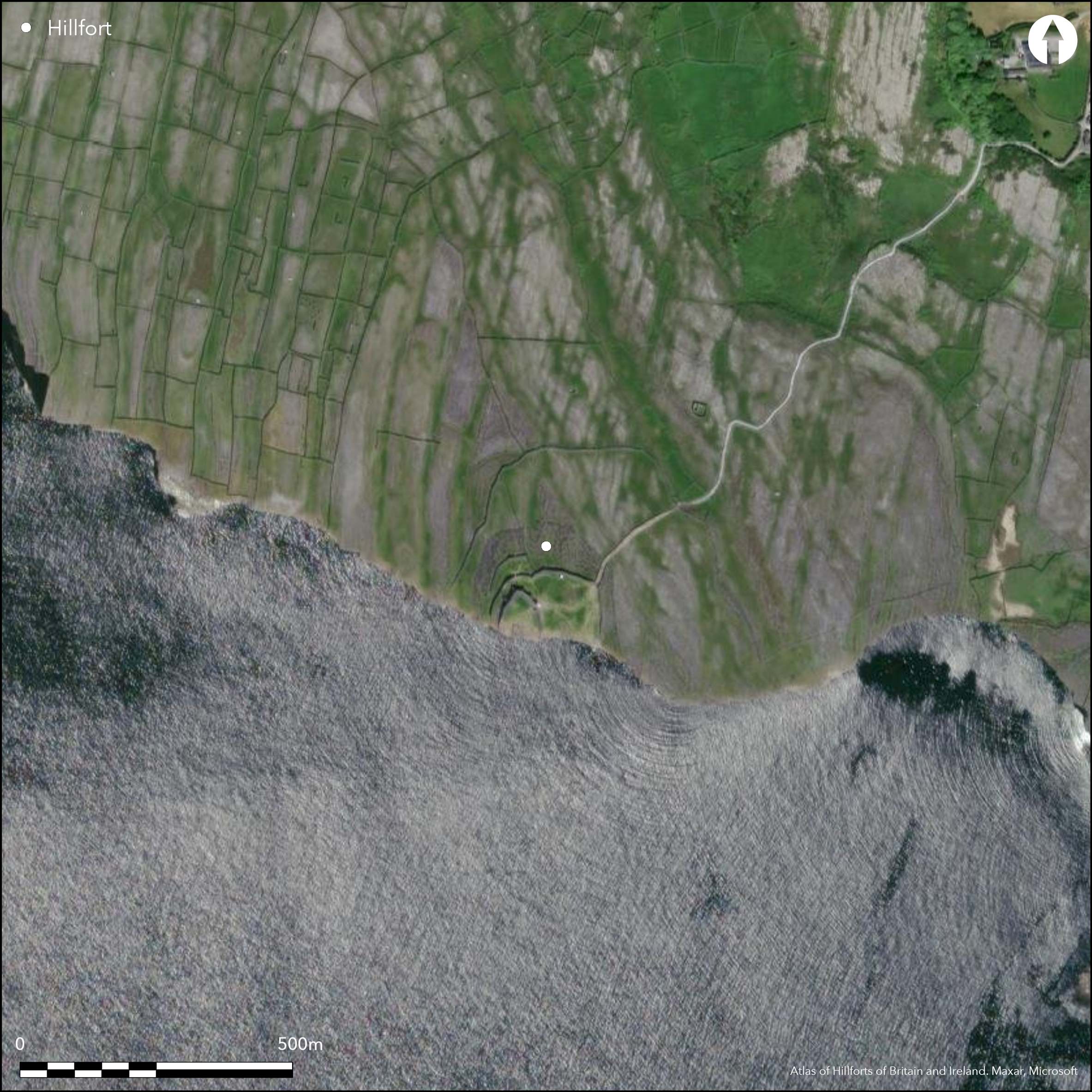
Satellite Imagery
Satellite Imagery
HER: Archaeological Survey of Ireland SMR Database GA110-039 (None)
NMR: GA 110 (None)
SM: None
NGR: None
X: 481783 Y: 709831 (IRENET95)
The famous coastal promontory fort of D–n Aonghasa, is located on the Aran Island of Inishmore, Co. Galway and overlooks the entrance to Galway Bay. It has a total site footprint of approximately 5.9ha and comprises up to four widely spaced enclosing elements which abut a sheer cliff face to the S. There were two main phases of construction. The fort was initially constructed at the beginning of the Late Bronze Age. A second phase of building and refurbishment took place later. This probably included the construction of the chevaux de frise. There are three entrances in the enclosing elements that may date to the Late Bronze Age and up to seven entrances which were probably added during the Early Medieval period (Cotter 2012a, 55). Up to ten structures were identified within the interior of the fort during excavation. A wide range of artifacts has also been identified. The stone banks have been substantially rebuilt in modern times. Excavations by Cotter in mid 1990's. Mainly Late Bronze Age dates. Iron Age and Early Medieval re-use of the site.
Citizen Science: ✗
Reliability of Data: Confirmed
Reliability of Interpretation: Confirmed
X: -1087187 Y: 7006320 (EPSG: 3857)
Longitude: -9.766363753127154 Latitude: 53.125899840869536 (EPSG:4326)
Country: Republic of Ireland
Current County or Unitary Authority: Galway
Historic County: Galway
Current Parish/Community/Council/Townland: Kilmurvy
The site has been extensively restored.
| Extant | ✓ |
| Cropmark | ✗ |
| Likely Destroyed | ✗ |
None
| Woodland | ✗ |
| Commercial Forestry Plantation | ✗ |
| Parkland | ✗ |
| Pasture (Grazing) | ✓ |
| Arable | ✗ |
| Scrub/Bracken | ✗ |
| Bare Outcrop | ✗ |
| Heather/Moorland | ✗ |
| Heath | ✗ |
| Built-up | ✗ |
| Coastal Grassland | ✗ |
| Other | ✗ |
Coastal promontory fort positioned at edge of cliff face to SW, on the Aran Island of Inishmore, overlooking entrance to Galway Bay. Interior of hillfort is level, however, the site as a whole is positioned on land sloping to the E.
| Contour Fort | ✗ |
| Partial Contour Fort | ✗ |
| Promontory Fort | ✓ |
| Hillslope Fort | ✗ |
| Level Terrain Fort | ✗ |
| Marsh Fort | ✗ |
| Multiple Enclosure Fort | ✗ |
| Hilltop | ✗ |
| Coastal Promontory | ✓ |
| Inland Promontory | ✗ |
| Valley Bottom | ✗ |
| Knoll/Hillock/Outcrop | ✗ |
| Ridge | ✗ |
| Cliff/Plateau-edge/Scarp | ✓ |
| Hillslope | ✗ |
| Lowland | ✗ |
| Spur | ✗ |
Dominant Topographic Feature: Cliff edge.
| North | ✗ |
| Northeast | ✗ |
| East | ✓ |
| Southeast | ✗ |
| South | ✗ |
| Southwest | ✗ |
| West | ✗ |
| Northwest | ✗ |
| Level | ✗ |
Altitude: 87.0m
N/A
A total of 43 radiocarbon dates from the site, many of these are Late Bronze Age, although the monument was re-used in Iron Age and Early Medieval period (see Warner 2013, 223). Samples relating to the construction of the fort are Late Bronze Age. Four radiocarbon dates suggest pre hillfort activity on the site.
Reliability: A - High
| Pre 1200BC | ✓ |
| 1200BC - 800BC | ✓ |
| 800BC - 400BC | ✗ |
| 400BC - AD50 | ✗ |
| AD50 - AD400 | ✗ |
| AD400 - AD 800 | ✗ |
| Post AD800 | ✗ |
| Unknown | ✗ |
| Pre Hillfort: | None |
| Post Hillfort: | None |
| C14: | None |
First edition Ordnance Survey maps only identified the inner enclosing elements of the site. Excavations by Cotter between 1992 and 1995.
| 1st Identified Map Depiction (1842): | First edition Ordnance Survey 6 inch mapping. |
| Excavation (None): | Cotter. |
Up to 10 possible structures were identified in the interior (Cotter 2012a, 267 _ 272). Two of these were dated; structure 8 (930 _ 810 BC) and 5 (350 _ 1 BC) (Cotter 2012b, 230). Cleary (2012, 9) notes that there is a minimum of 340 vessels from these excavations, the bulk of which came from layers that seem to have been deposited mainly in the period 1000 _ 800 cal. BC. Other likely Late Bronze Age finds included 460 fragments of clay crucible moulds. Eight types of instruments or weapons were definitively identified from moulds, including 1 sword, 2 spearheads, 3 socketed axe-heads, 2 knives, 2 ball pinheads, 4 disc heads or decorated studs/buttons, 4 pin shanks and 2 rings/bracelets (OCarroll 2012a). Further evidence for the casting of these items is apparent in the 28 sherds of crucibles of varying size and form. Traces of copper-alloy identified on the outer surface of one complete example attests to their use (OCarroll 2012b). A large corpus of finds was recovered, mainly from the inner enclosure, including 40 bronze objects, the most famous of which are the four Bronze rings (Cotter 2012b, 48 _ 49). 17 pieces of amber, the majority in the form of beads (Feeney-Johnson 2012, 93) attest to potential continental trade networks. Analysis of these confirm that, with the exception of one example, all amber finds were made from Baltic succinate (Feeney-Johnson 2012, 96). 14 Iron Age/Early Medieval blue glass beads attest to later occupation of the hillfort (Fitzgerald and Warner 2012). Numerous stone, bone and iron implements were also recovered from the site. The fish bone assemblage from D–n Aonghasa constitutes the largest collection of Bronze Age fish bone in Ireland (McCarthy 2012, 172). These bones, in combination with large quantities of recovered shells, indicate exploitation of nearby marine resources. The identification of eleven different species of fish reflects the variety available in the vicinity of the site (McCarthy 2012, 173). This unique availability of faunal resources at the Aran Islands is partly the result of the islands being at the meeting of northern and southern temperate waters, where species from both bodies meet and mix (OConnell and Roden 1994, 47). It is clear, however, that the most important economic activity was pastorial (McCarthy 2012, 173).
None
| None | ✓ |
| Spring | ✗ |
| Stream | ✗ |
| Pool | ✗ |
| Flush | ✗ |
| Well | ✗ |
| Other | ✗ |
None
| No Known Features | ✓ |
| Round Stone Structures | ✗ |
| Rectangular Stone Structures | ✗ |
| Curvilinear Platforms | ✗ |
| Other Roundhouse Evidence | ✗ |
| Pits | ✗ |
| Quarry Hollows | ✗ |
| Other | ✗ |
None
| No Known Excavation | ✗ |
| Pits | ✓ |
| Postholes | ✓ |
| Roundhouses | ✓ |
| Rectangular Structures | ✗ |
| Roads/Tracks | ✗ |
| Quarry Hollows | ✗ |
| Other | ✗ |
| Nothing Found | ✗ |
None
| No Known Geophysics | ✓ |
| Pits | ✗ |
| Roundhouses | ✗ |
| Rectangular Structures | ✗ |
| Roads/Tracks | ✗ |
| Quarry Hollows | ✗ |
| Other | ✗ |
| Nothing Found | ✗ |
None
| No Known Finds | ✗ |
| Pottery | ✓ |
| Metal | ✓ |
| Metalworking | ✓ |
| Human Bones | ✓ |
| Animal Bones | ✓ |
| Lithics | ✓ |
| Environmental | ✓ |
| Other | ✗ |
NO APPARENT FEATURES
| APs Not Checked | ✓ |
| None | ✗ |
| Roundhouses | ✗ |
| Rectangular Structures | ✗ |
| Pits | ✗ |
| Postholes | ✗ |
| Roads/Tracks | ✗ |
| Other | ✗ |
There are two breaks in the inner enclosing elements. These comprise a small mural passage at NNW and a lintelled gate 1.2m wide and up to 2m high at N (Gosling 1993, 30). The later is likely to be original. There is a blocked-up gate at the NE of the second enclosing element. Two further entrance gaps at the N are likely to be later in date (Cotter 2012a, 51 - 58). Break in third enclosing element at NW. Break in outer enclosing elements at the N (Cotter 2012a).
| 7: | None |
| 2: | These three gaps are likely to represent the original Late Bronze Age entrances. The remaining four are likely to represent entrances that were present by the Early Medieval period (Cotter 2012a, 55). |
Guard Chambers: ✗
Chevaux de Frise: ✓
Chevaux de fries outside the remains of the third enclosing element. This remains undated. Avenue though chevaux de frise at NE
| 1. Simple Gap (North): | Lintelled gate. |
| 2. Blocked (North): | Blocked simple gap. |
| 3. Simple Gap (North): | Simple break in enclosing elements |
The inner wall survives to a height of 4.9m and varies from 3.5m to 5.8m in width at its base, although this enclosing element has been rebuilt in relatively recent times, with the addition of external buttresses. This enclosure surrounds an area of 0.15ha. The wall has two internal tiers with access provided by a number of steps which are built into the wall (Cotter 2012a, 54). A sample of animal bone from residue on a sherd of pottery from an occupation layer deposited «soon after the construction of the abutting inner enclosing element of the hillfort returned a date of 980_810 BC (Cotter 2012a, 158 _ 163; Warner 2012, 224). Underneath this layer, another occupation surface returned a date of 1070_890 BC (Cotter 2012a, 158; Warner 2012, 224). These lay underneath the «refurbishment of the inner enclosure, where the walls of the enclosing element were thickened by 3_4m (Cotter 2012a, 171). The middle enclosing element survives to a height of 4m and varies from 1.6m to 3.8m in width at its base. It abuts the northern portion of the inner wall and encloses an area of 0.92ha mainly to the east of the inner enclosure. Dating evidence for the construction of this wall comes from occupation refuse underneath the lower terrace of wall 1. Two radiocarbon samples dating to 130 _1050 BC and 1250_1000 BC are supported by samples from contexts after the construction of the wall which date to 1080_510 BC, confirming these two dates as likely to be representative of the initial construction of the hillfort (Cotter 2012a, 64; Warner 2012). The outer wall survives to a maximum height of 1.5m. While this is substantially lower than the other potentially contemporary enclosing elements, the outer wall is built along a terrace for most of its length. This further augmented the outer wall, by making it appear more defensible from the exterior. The remains of an internal terrace is visible at the N and NW section. Much of the outer enclosing element is decapitated, with only the northern and eastern sections remaining upstanding. The outer wall was not dated, and there is no evidence to suggest if this is contemporary or later than the middle and inner enclosing elements (Cotter 2012a, 88), although Cotter (2012a, 88) suggests that it is unlikely to post-date the chevaux de frise, as this feature cuts off the outer enclosure from the rest of the hillfort. A broad band of chevaux de frise (0.6ha of closely spaced upright stone pillars) is positioned immediately outside the middle enclosure. This is rare in an Irish context. A fourth wall partially survives (63m in length) abutting the NW edge of the chevaux de fries. It is likely that this continued further east (to about 0.92ha), although upon excavation, there was no definitive evidence for this (Cotter 2012a, 134 _ 135). The wall survives to an average height of 2m and ranges from 1.5m to 2.6m in width. Although both of these features are undated, Cotter (2012a, 55) suggests that they belong to a separate, later phase of activity at the site.
| Area 1: | 0.15ha. |
| Area 2: | 0.72ha. |
| Area 3: | 0.92ha. |
| Area 4: | 5.7ha. |
| Total: | 5.7ha. |
Total Footprint Area: 5.85ha.
None
| ✗ | None |
| ✗ | None |
| NE Quadrant: | 4 |
| SE Quadrant: | 0 |
| SW Quadrant: | 0 |
| NW Quadrant: | 3 |
| Total: | 4 |
| Partial Univallate | ✗ |
| Univallate | ✗ |
| Partial Bivallate | ✗ |
| Bivallate | ✗ |
| Partial Multivallate | ✓ |
| Multivallate | ✗ |
| Unknown | ✗ |
| Partial Univallate | ✗ |
| Univallate | ✗ |
| Partial Bivallate | ✗ |
| Bivallate | ✗ |
| Partial Multivallate | ✗ |
| Multivallate | ✗ |
None
| None | ✗ |
| Earthen Bank | ✗ |
| Stone Wall | ✓ |
| Rubble | ✗ |
| Wall-walk | ✗ |
| Evidence of Timber | ✗ |
| Vitrification | ✗ |
| Other Burning | ✗ |
| Palisade | ✗ |
| Counter Scarp Bank | ✗ |
| Berm | ✗ |
| Unfinished | ✗ |
| Other | ✗ |
None
| None | ✗ |
| Earthen Bank | ✗ |
| Stone Wall | ✓ |
| Murus Duplex | ✗ |
| Timber-framed | ✗ |
| Timber-laced | ✗ |
| Vitrification | ✗ |
| Other Burning | ✗ |
| Palisade | ✗ |
| Counter Scarp Bank | ✗ |
| Berm | ✗ |
| Unfinished | ✗ |
| No Known Excavation | ✗ |
| Other | ✗ |
| ✗ | None |
| ✗ | None |
Number of Ditches: 0
| ✗ | None. |
Cotter, C. 2012a. The Western Stone Forts Project: Excavations at Dñn Aonghasa and Dñn Eoghanachta, I, Wordwell, Dublin.
Cotter, C. 2012b. The Western Stone Forts Project: Excavations at Dñn Aonghasa and Dñn Eoghanachta, II, Wordwell, Dublin.
Feeney-Johnson, C. 2012. Amber beads. In Cotter, C., The Western Stone Forts Project: Excavations at Dñn Aonghasa and Dñn Eoghanachta, II. Discovery Programme Monograph, Wordwell, Dublin. 93-98.
FitzGerald, M. and Warner, R. 2012. Blue glass beads. In Cotter, C., The Western Stone Forts Project: Excavations at Dñn Aonghasa and Dñn Eoghanachta, II. Discovery Programme Monograph, Wordwell, Dublin. 98-102.
Gosling, C. 1993. Archaeological Inventory of County Galway, Vol. I. The Stationary Office, Dublin.
Harbison, P 1971 Wooden and stone chevaux-de frise in central and western Europe. Proc Prehist Soc 37 (1971), 195-225 (203-5, fig 9)
McCarthy, M. 2012. Fish bone and sea mammal bone. In Cotter, C., The Western Stone Forts Project: Excavations at Dñn Aonghasa and Dñn Eoghanachta, II. Discovery Programme Monograph, Wordwell, Dublin. 167-174.
O'Carroll, F. 2012a. Clay moulds. In Cotter, C., The Western Stone Forts Project: Excavations at Dñn Aonghasa and Dñn Eoghanachta, II. Discovery Programme Monograph, Wordwell. Dublin. 28-41.
O'Carroll, F. 2012b. The crucible assemblage. In Cotter, C., The Western Stone Forts Project: Excavations at Dñn Aonghasa and Dñn Eoghanachta, II. Discovery Programme Monograph, Wordwell, Dublin. 42-44.
O'Connell, M. and Roden, C. 1994. The natural history of the sea. In Waddell, J., O'Connell, J. and Korff, A. (eds.) The Book of Aran. Tr Eolas, Kinvara. 47-56.
Warner, R. 2012. «The radiocarbon dates from Dñn Aonghasa», in C. Cotter, The Western Stone Forts Project: Excavations at Dñn Aonghasa and Dñn Eoghanachta, II. 211-224.
Atlas of Hillforts:
Wikidata:
This work is licensed under CC BY-SA 4.0

 and should be cited as:
Lock, Gary and Ralston, Ian. 2024. Atlas of Hillforts of Britain and Ireland. Available at: https://hillforts.arch.ox.ac.uk
Document Version 1.1