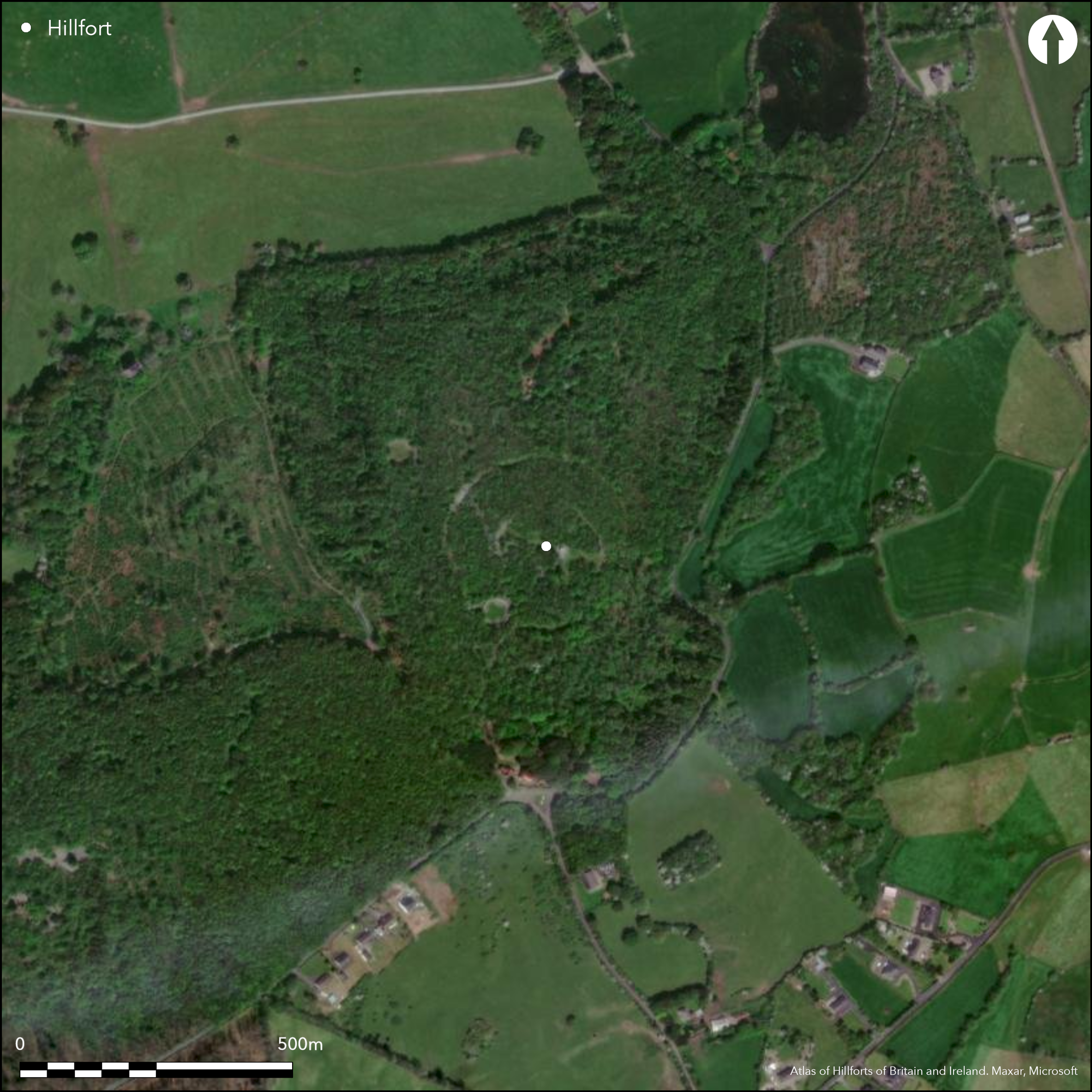
Satellite Imagery
Satellite Imagery
HER: Archaeological Survey of Ireland SMR Database CL042-074001 (None)
NMR: CL 042 (None)
SM: None
NGR: None
X: 540742 Y: 670568 (IRENET95)
Near the village of Newmarket-on-Fergus, an oval multiple enclosure with a total site footprint of approximately 11.1ha, in commanding position overlooking low-lying terrain and the Shannon Estuary to the S and W. Trivallate for the entire circuit with two possible entrance features in the inner and outer enclosing elements. Up to nine other breaks in the banks of the hillfort may be modern. Up to nine hut structures, six enclosures and three cairns within the interior attesting to pre-hillfort, post-hillfort and contemporary occupation of the hilltop. A number of quarry pits may also be contemporary with the construction of the fort. Ramparts survive well throughout their circuits. Extensive tree cover within interior. First map identification in the Ordnance Survey first edition maps. Thomas Westropp (1893, 1908) produced a number of papers on the monuments of in the region and commented on Mooghaun. More detailed earthwork survey in the second edition Ordnance Survey maps. Excavation by Grogan 1992-1995. Late Bronze Age construction dates. Pre-hillfort activity recorded and extensive evidence for the re-use of the hillfort in the Early Medieval period (Grogan 2005a).
Citizen Science: ✗
Reliability of Data: Confirmed
Reliability of Interpretation: Confirmed
X: -988340 Y: 6942936 (EPSG: 3857)
Longitude: -8.878407838169167 Latitude: 52.782874603865885 (EPSG:4326)
Country: Republic of Ireland
Current County or Unitary Authority: Clare
Historic County: Clare
Current Parish/Community/Council/Townland: Mooghaun
None
| Extant | ✓ |
| Cropmark | ✗ |
| Likely Destroyed | ✗ |
None
| Woodland | ✓ |
| Commercial Forestry Plantation | ✗ |
| Parkland | ✓ |
| Pasture (Grazing) | ✗ |
| Arable | ✗ |
| Scrub/Bracken | ✓ |
| Bare Outcrop | ✗ |
| Heather/Moorland | ✗ |
| Heath | ✗ |
| Built-up | ✗ |
| Coastal Grassland | ✗ |
| Other | ✗ |
Large multiple enclosure in commanding position in hilltop in low-lying terrain and overlooking the Shannon Estuary to the S and W. Panoramic views from the summit..
| Contour Fort | ✓ |
| Partial Contour Fort | ✗ |
| Promontory Fort | ✗ |
| Hillslope Fort | ✗ |
| Level Terrain Fort | ✗ |
| Marsh Fort | ✗ |
| Multiple Enclosure Fort | ✓ |
| Hilltop | ✓ |
| Coastal Promontory | ✗ |
| Inland Promontory | ✗ |
| Valley Bottom | ✗ |
| Knoll/Hillock/Outcrop | ✗ |
| Ridge | ✗ |
| Cliff/Plateau-edge/Scarp | ✗ |
| Hillslope | ✗ |
| Lowland | ✗ |
| Spur | ✗ |
Dominant Topographic Feature: Hilltop
| North | ✗ |
| Northeast | ✗ |
| East | ✗ |
| Southeast | ✗ |
| South | ✗ |
| Southwest | ✗ |
| West | ✗ |
| Northwest | ✗ |
| Level | ✓ |
Altitude: 78.0m
N/A
Ten Late Bronze Age radiocarbon estimations dating the construction and occupation of the hillfort. Other radiocarbon dates and the lithics assemblage attest to pre-hillfort occupation of the hilltop. Early Medieval hut structures and ringfort monuments confirm the hillfort was reused during this period (Grogan 2005a).
Reliability: A - High
| Pre 1200BC | ✗ |
| 1200BC - 800BC | ✓ |
| 800BC - 400BC | ✗ |
| 400BC - AD50 | ✗ |
| AD50 - AD400 | ✗ |
| AD400 - AD 800 | ✗ |
| Post AD800 | ✗ |
| Unknown | ✗ |
| Pre Hillfort: | None |
| Post Hillfort: | None |
| Artefactual: | Lithics, coarse ware pottery |
| C14: | None |
First map identification in the Ordnance Survey first edition maps. Thomas Westropp (1893, 1908) produced a number of papers on the monuments of in the region and commented on Mooghaun. More detailed earthwork survey in the second edition Ordnance Survey maps. Excavation by Grogan 1992-1995.
| 1st Identified Map Depiction (1842): | First edition Ordnance Survey 6 inch mapping. |
| 1st Identified Written Reference (1893): | Westropp |
| Other (1906): | Second edition Ordnance Survey 25 inch mapping. |
| Other (1998): | Visited by Hillfort Study Group |
| Excavation (None): | Grogan |
Up to nine hut structures have been identified within the interior. Two hut structures abutting the middle enclosing element may have been associated with pre-rampart construction or the initial building of the rampart itself (Grogan 2005a, 183 _ 184). A radiocarbon date from another structure between the inner and middle enclosing elements dates the hut to the Early Medieval period, attesting to later activity at the site. There are six larger enclosures within the hillfort. One of these is dated to the Early Medieval period. There are three cairns within the hillfort. All of these remain undated. A number of quarry pits may also be contemporary with the construction of the fort. The artifactual assemblage is consistent with the radiocarbon evidence, suggesting both pre-hillfort and post-hillfort occupation.
None
| None | ✓ |
| Spring | ✗ |
| Stream | ✗ |
| Pool | ✗ |
| Flush | ✗ |
| Well | ✗ |
| Other | ✗ |
Up to nine hut-structures, six large enclosures and three cairns
| No Known Features | ✗ |
| Round Stone Structures | ✗ |
| Rectangular Stone Structures | ✗ |
| Curvilinear Platforms | ✗ |
| Other Roundhouse Evidence | ✗ |
| Pits | ✗ |
| Quarry Hollows | ✗ |
| Other | ✓ |
Hut-structures and enclosures
| No Known Excavation | ✗ |
| Pits | ✗ |
| Postholes | ✗ |
| Roundhouses | ✗ |
| Rectangular Structures | ✗ |
| Roads/Tracks | ✗ |
| Quarry Hollows | ✗ |
| Other | ✓ |
| Nothing Found | ✗ |
None
| No Known Geophysics | ✓ |
| Pits | ✗ |
| Roundhouses | ✗ |
| Rectangular Structures | ✗ |
| Roads/Tracks | ✗ |
| Quarry Hollows | ✗ |
| Other | ✗ |
| Nothing Found | ✗ |
None
| No Known Finds | ✗ |
| Pottery | ✓ |
| Metal | ✗ |
| Metalworking | ✓ |
| Human Bones | ✗ |
| Animal Bones | ✓ |
| Lithics | ✓ |
| Environmental | ✗ |
| Other | ✗ |
NO APPARENT FEATURES
| APs Not Checked | ✗ |
| None | ✓ |
| Roundhouses | ✗ |
| Rectangular Structures | ✗ |
| Pits | ✗ |
| Postholes | ✗ |
| Roads/Tracks | ✗ |
| Other | ✗ |
Four gaps in the inner enclosing elements. Simple gap 0.9m wide on the SE side may be original. This narrow passage is internally faced and comprises an angled passage through the bank. The passage is flanked with roughly coursed blocks and about midway, the passage turns sharply. Narrow horns flank the gap on the outside, forming a funnel extending in towards the gap (Grogan 2005a, 141). A single 2.4m gap in the outer enclosing elements at the SW may be original (Grogan 2005a, 122). This gap is flanked by by external in-curving hornworks extending from the terminals of both banks.
| 11: | None |
| 2: | There was only one entrance Grogan (2005a) interpreted as an original gap, however, he dies not discuss the majority of the possible entrance breaks. Therefore, there are likely to be more possible original entrance features, however, without out further information or excavation, this is impossible to determine. |
Guard Chambers: ✗
Chevaux de Frise: ✗
| 1. Passage-way/Corridor (South east): | None |
| 2. In-turned (South west): | None |
The hillfort comprises three widely spaced limestone rubble banks, occupying a total area of 11.05ha. The banks largely follow the contours of the hill, taking advantage of naturally steep slopes to make the defences seem larger from the exterior. The inner enclosing element surrounds a sub-circular area 0.76ha. in extent. The stone bank varies from 6_9m in width and is on average 1.5m in height (Grogan 2005a, 118). There is no apparent ditch feature. A single radiocarbon date was taken from animal bone mixed within the inner bank material, dating to 922_813 BC (Grogan 2005a, 144). The middle enclosing element is roughly concentric with the inner example and occupies an area of 2.88ha. The bank is 8_11m wide and rises to a height of 3.5m on the exterior and 2m internally (Grogan 2005a, 119). Again, there is no apparent ditch feature. A smaller concentric wall placed 3m inside the main bank can be traced for 80m, however, it is unknown how this relates to the main period of hillfort occupation (Grogan 2005a, 120). A series of radiocarbon dates were attained for the middle enclosing element (see Grogan 2005a, Table 6.1) dating the original construction of the bank to 1125_918 BC, with subsequent alterations occurring between 1000 BC to 800 BC (Grogan 2005a, 186). The outer enclosing element is oval and encloses an area of 11.05ha. It comprises a large inner bank, 12_15m wide, an intervening ditch 5m in average width, and a smaller outer bank (Grogan 2005a, 121). A charcoal sample from a burnt surface directly underneath the bank, but outside the «setting-out line effectively dates the construction of this enclosing element to 1255_917 BC (Grogan 2005a, 188). Grogan (2005a, 128) suggests that the radiocarbon dates for the three enclosing elements imply that they were likely conceived of, constructed and functioned at the same time.
| Area 1: | 0.76ha. |
| Area 2: | 2.88ha. |
| Area 3: | 10.85ha. |
| Total: | 10.85ha. |
Total Footprint Area: 11.05ha.
None
| ✗ | None |
| ✓ | None |
| NE Quadrant: | 3 |
| SE Quadrant: | 3 |
| SW Quadrant: | 3 |
| NW Quadrant: | 3 |
| Total: | 3 |
| Partial Univallate | ✗ |
| Univallate | ✗ |
| Partial Bivallate | ✗ |
| Bivallate | ✗ |
| Partial Multivallate | ✗ |
| Multivallate | ✓ |
| Unknown | ✗ |
| Partial Univallate | ✗ |
| Univallate | ✓ |
| Partial Bivallate | ✗ |
| Bivallate | ✗ |
| Partial Multivallate | ✗ |
| Multivallate | ✗ |
None
| None | ✗ |
| Earthen Bank | ✗ |
| Stone Wall | ✗ |
| Rubble | ✓ |
| Wall-walk | ✗ |
| Evidence of Timber | ✗ |
| Vitrification | ✗ |
| Other Burning | ✗ |
| Palisade | ✗ |
| Counter Scarp Bank | ✗ |
| Berm | ✗ |
| Unfinished | ✗ |
| Other | ✗ |
Stone rubble banks
| None | ✗ |
| Earthen Bank | ✗ |
| Stone Wall | ✗ |
| Murus Duplex | ✗ |
| Timber-framed | ✗ |
| Timber-laced | ✗ |
| Vitrification | ✗ |
| Other Burning | ✗ |
| Palisade | ✗ |
| Counter Scarp Bank | ✓ |
| Berm | ✗ |
| Unfinished | ✗ |
| No Known Excavation | ✗ |
| Other | ✓ |
| ✗ | None |
| ✓ | Accompanying outer enclosure |
Number of Ditches: 1
| ✗ | None. |
Westropp, T. 1893. Prehistoric stone forts of central Clare- Moghane and Langough, near Dromoland. Journal of the Royal Society of Antiquaries of Ireland 33, 281-291.
Westropp, T. 1908. Types of the ring-forts and similar structures remaining in eastern Clare (the Newmarket Group). Proceedings of the Royal Irish Academy 27C, 217-235.
Grogan, 2005a. The North Munster Project I. Wordwell, Dublin.
Grogan, 2005b. The North Munster Project II. Wordwell, Dublin.
Atlas of Hillforts:
Wikidata:
This work is licensed under CC BY-SA 4.0

 and should be cited as:
Lock, Gary and Ralston, Ian. 2024. Atlas of Hillforts of Britain and Ireland. Available at: https://hillforts.arch.ox.ac.uk
Document Version 1.1