Satellite Imagery
Satellite Imagery
HER: Archaeological Survey of Ireland SMR Database CO151-040 (None)
NMR: CO 151 (None)
SM: None
NGR: None
X: 514394 Y: 526202 (IRENET95)
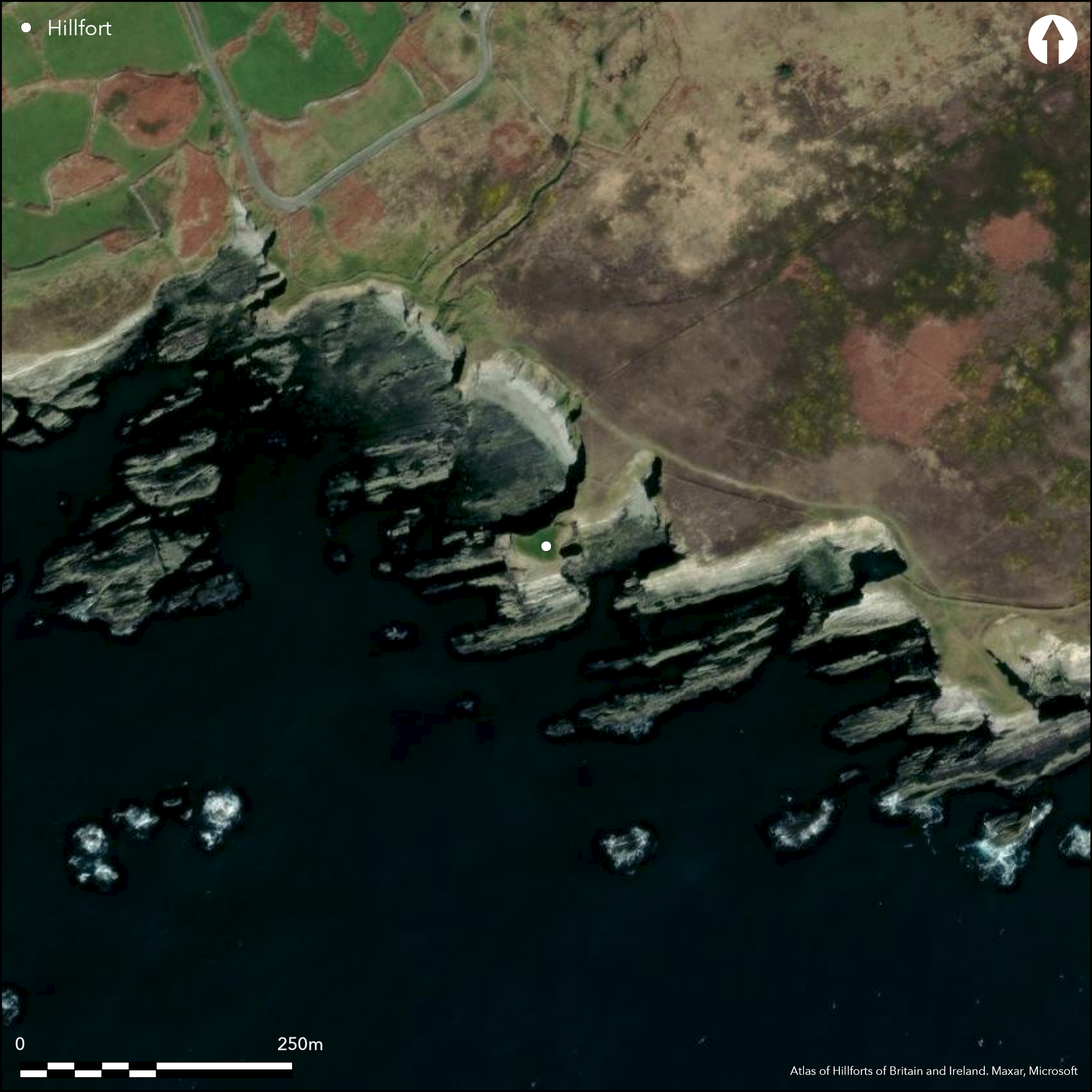
The site is located c. 7.5km SE of Skibereen town, West Cork. It lies on the exposed coastline to the W of the point marked 'Toe Head' on the OS. map and is a little more than 1.5 miles SW of the promontory at Portadoona (CO151-032; Atlas No.0825). It is composed of a sub-rectangular area of approximately 0.06ha (22m E-W by 27m N-S) projecting S into the Atlantic at an altitude of 6m OD. It is connected to the mainland by a narrow neck with a V-shaped profile. Although marked on the OS map as 'Dooneendermotmore' the site is known locally as 'T†n D–in'n' (O'Kelly 1952, 35). Westropp describes this coastal promontory as a 'platform fort' having a deep natural hollow across the neck, usually crossed by a narrow gangway (1914, 104). Excavation by O'Kelly indicated that the earliest phase of activity on the site was the deep ditch that cut across the narrow neck of land that separated the site from the mainland. This ditch was re-cut during the Later Medieval period when the headland was refortified with a formal entrance causeway and stone parapet wall (1952, 35-54). The excavation produced no evidence of occupation contemporary with the earliest phase of fortification. Site now partially overgrown and subject to erosion.
Citizen Science: ✗
Reliability of Data: Confirmed
Reliability of Interpretation: Confirmed
X: -1027763 Y: 6706997 (EPSG: 3857)
Longitude: -9.232553202283432 Latitude: 51.481976131815294 (EPSG:4326)
Country: Republic of Ireland
Current County or Unitary Authority: Cork
Historic County: Cork
Current Parish/Community/Council/Townland: Dooneenmacotter
While the site is extant, O'Kelly noted that the site must have extended further to the S 'where there now exists a bare expanse of rugged and torn rock' (1952, 36). The narrow neck of land which connects the site to the mainland continues to be seriously undermined.
| Extant | ✓ |
| Cropmark | ✗ |
| Likely Destroyed | ✗ |
The site is now partially overgrown by srub
| Woodland | ✗ |
| Commercial Forestry Plantation | ✗ |
| Parkland | ✗ |
| Pasture (Grazing) | ✗ |
| Arable | ✗ |
| Scrub/Bracken | ✓ |
| Bare Outcrop | ✗ |
| Heather/Moorland | ✗ |
| Heath | ✗ |
| Built-up | ✗ |
| Coastal Grassland | ✗ |
| Other | ✗ |
The fort is located on a slight S-facing slope at an altitude of 6m OD. It is a small sub-rectangular area projecting S into the Atlantic; connected to the mainland by a narrow neck of land. The only access to the promontory is through this narrow approach, averaging about 1.5m wide. On the N side there is a vertical drop of 15m while the S side is less severe. All along the N side of the fort the cliff is vertical and 18m high and this applies also to the section on the E side.
| Contour Fort | ✗ |
| Partial Contour Fort | ✗ |
| Promontory Fort | ✓ |
| Hillslope Fort | ✗ |
| Level Terrain Fort | ✗ |
| Marsh Fort | ✗ |
| Multiple Enclosure Fort | ✗ |
| Hilltop | ✗ |
| Coastal Promontory | ✓ |
| Inland Promontory | ✗ |
| Valley Bottom | ✗ |
| Knoll/Hillock/Outcrop | ✗ |
| Ridge | ✗ |
| Cliff/Plateau-edge/Scarp | ✗ |
| Hillslope | ✗ |
| Lowland | ✗ |
| Spur | ✗ |
Dominant Topographic Feature: S -facing promontory
| North | ✗ |
| Northeast | ✗ |
| East | ✗ |
| Southeast | ✗ |
| South | ✓ |
| Southwest | ✗ |
| West | ✗ |
| Northwest | ✗ |
| Level | ✗ |
Altitude: 6.0m
N/A
The site is not scientifically dated and the artefacts recovered during the excavation were associated with the High Medieval phase of activity on the site.
Reliability: D - None
| Pre 1200BC | ✗ |
| 1200BC - 800BC | ✗ |
| 800BC - 400BC | ✗ |
| 400BC - AD50 | ✗ |
| AD50 - AD400 | ✗ |
| AD400 - AD 800 | ✗ |
| Post AD800 | ✓ |
| Unknown | ✓ |
| Pre Hillfort: | None |
| Post Hillfort: | The promontory was refortified during the High Medieval period when the ditch/fosse was re-cut and a stone causeway was constructed on the landward side. According to O'Kelly, a wooden drawbridge may have linked the causeway to the interior (1952, 42). Along the edge of the promontory, sections of curtain wall survived, particularly to the N. On the S side of the enclosure, excavation revealed low courses of a rectangular structure. The house had an internal partition wall with the smaller room used as a kitchen with the remains of a 'hearth or wall-oven' in one corner. The house was destroyed by fire, as the charred remains of wooden roof timbers and slates were revealed during the excavation on the floor of the structure. Associated with the occupation of the house was pottery of the period 1550-1650 and lead ball bullets of c. 1650. |
| Artefactual: | The artefacts recovered during the excavation are associated with the High Medieval phase of activity on the site. |
Depicted on second edition OS six-inch maps as 'Donneendermotmore'. Described by Westropp as the stronghold of Diarmuid M†r or 'Big Dermot' with reference to the placename 'Toanadwnin' which he though must have been connected to the name depicted on the OS map (1914,1044-5). Westropp also describes the stone walls or 'revetments' as 'beautifully neat flag-masonry, 7feet 6 inch thick and over 10 feet high outside' (1914, 105). He goes on to describe a possible souterrain at the S end near the rectangular house as 'a passage 3 feet wide and high running eastward for 15 feet; at 3 feet from its eastern end is a similar south passage 12 feet long under the wall to a natural staircase leading to a lower shelf on the south flank of the rock' (1914, 105). This possible souterrain was later dismissed by O'Kelly as the remains of the Medieval house, mistaken by Westropp as an underground passage (1952, 39). The site was excavated by O'Kelly, where the remains of a Medieval house, curtain wall and stone causeway were revealed. The earlier ditch was shown to be re-cut during this phase of activity. The excavation produced no evidence of occupation contemporary with the earliest phase of fortification. Site visited and surveyed by the Cork Archaeological Survey in the late 1980s (Power et al. 1992).
| 1st Identified Map Depiction (1842): | OS six-inch mapping |
| 1st Identified Written Reference (1914): | Thomas Westropp |
| Excavation (1952): | M.J.O'Kelly (UCC) |
| Earthwork Survey (1992): | Cork Archaeological Survey |
Rectangular structure shown on 1845 OS map. Excavation confirmed that this was High Medieval in date and associated with a later phase of activity on the headland. There are no visible internal structures relating to the earliest phases in the interior of the fort.
None
| None | ✓ |
| Spring | ✗ |
| Stream | ✗ |
| Pool | ✗ |
| Flush | ✗ |
| Well | ✗ |
| Other | ✗ |
Rectangular structure dating to High Medieval period.
| No Known Features | ✗ |
| Round Stone Structures | ✗ |
| Rectangular Stone Structures | ✓ |
| Curvilinear Platforms | ✗ |
| Other Roundhouse Evidence | ✗ |
| Pits | ✗ |
| Quarry Hollows | ✗ |
| Other | ✗ |
On the S side of the enclosure, excavation revealed low courses of a rectangular structure. The house had an internal partition wall with the smaller room used as a kitchen with the remains of a 'hearth or wall-oven' in one corner. The house was destroyed by fire. Artefacts recovered from the structure confirmed that it was High Medieval in date c. 16-17th century (O'Kelly 1952, 39-51).
| No Known Excavation | ✗ |
| Pits | ✗ |
| Postholes | ✗ |
| Roundhouses | ✗ |
| Rectangular Structures | ✓ |
| Roads/Tracks | ✗ |
| Quarry Hollows | ✗ |
| Other | ✗ |
| Nothing Found | ✗ |
None
| No Known Geophysics | ✓ |
| Pits | ✗ |
| Roundhouses | ✗ |
| Rectangular Structures | ✗ |
| Roads/Tracks | ✗ |
| Quarry Hollows | ✗ |
| Other | ✗ |
| Nothing Found | ✗ |
Artefacts recovered during excavation include 16th and 17th century pottery, glass, iron nails, stone discs, eight quern stones, gun flint, bronze fragments, a complete pickaxe head, a pewter spoon, charred rope fragments and lead bullets. All of the finds were recovered from the 'mediavel stratum' and 'no object was discovered which could be attributed to the builders of the fort' (O'Kelly 1952, 43).
| No Known Finds | ✗ |
| Pottery | ✓ |
| Metal | ✓ |
| Metalworking | ✗ |
| Human Bones | ✗ |
| Animal Bones | ✗ |
| Lithics | ✓ |
| Environmental | ✗ |
| Other | ✗ |
NO APPARENT FEATURES
| APs Not Checked | ✗ |
| None | ✓ |
| Roundhouses | ✗ |
| Rectangular Structures | ✗ |
| Pits | ✗ |
| Postholes | ✗ |
| Roads/Tracks | ✗ |
| Other | ✗ |
No evidence of original entrance to the site. That said, the only access to the site is through the narrow neck of land where the medieval causeway and possible drawbridge probably destroyed any evidence of original access point.
| 1: | None |
| 2: | None |
Guard Chambers: ✗
Chevaux de Frise: ✗
| 1. Other Forms (North): | The fort was accessed through a stone casueway constructed on the landward side of the ditch. There was no evidence of a rampart or bank associated with the ditch. The stone casueway related to the medieval fortification and according to O'Kelly, a wooden drawbridge probably linked the stone casueway to the interior of the fort (O'Kelly 1952, 42). |
There was no evidence of original banks or ramparts to the site. The stone walls revealed during excavation were shown to be High Medieval in date. A single ditch was evident composed of a natural hollow running at right angles across the narrow neck that connected the mainland to the fort. This natural hollow had been deepened by the original builders of the fort who cut through the boulder clay and into the underlying rock. O'Kelly suggests that the material cut from the ditch 'must have been thrown over the cliffs' (1952, 42). The ditch was later re-cut during the High Medieval phase.
| Area 1: | 0.06ha. |
| Total: | 0.06ha. |
Total Footprint Area: 0.06ha.
None
| ✗ | None |
| ✗ | There is no evidence of original banks/ramparts. Excavation confirmed that the stone walls were curtain walls of High Medieval date. Ditch located across neck |
| NE Quadrant: | 1 |
| SE Quadrant: | 0 |
| SW Quadrant: | 0 |
| NW Quadrant: | 0 |
| Total: | 1 |
| Partial Univallate | ✓ |
| Univallate | ✗ |
| Partial Bivallate | ✗ |
| Bivallate | ✗ |
| Partial Multivallate | ✗ |
| Multivallate | ✗ |
| Unknown | ✗ |
| Partial Univallate | ✗ |
| Univallate | ✗ |
| Partial Bivallate | ✗ |
| Bivallate | ✗ |
| Partial Multivallate | ✗ |
| Multivallate | ✗ |
No evidence of original ramparts
| None | ✓ |
| Earthen Bank | ✗ |
| Stone Wall | ✗ |
| Rubble | ✗ |
| Wall-walk | ✗ |
| Evidence of Timber | ✗ |
| Vitrification | ✗ |
| Other Burning | ✗ |
| Palisade | ✗ |
| Counter Scarp Bank | ✗ |
| Berm | ✗ |
| Unfinished | ✗ |
| Other | ✗ |
The low walls revealed on the N side and southern side of the promontory were shown to be related to the High Medieval phase of activity on the site. Ditch discovered on neck
| None | ✗ |
| Earthen Bank | ✗ |
| Stone Wall | ✗ |
| Murus Duplex | ✗ |
| Timber-framed | ✗ |
| Timber-laced | ✗ |
| Vitrification | ✗ |
| Other Burning | ✗ |
| Palisade | ✗ |
| Counter Scarp Bank | ✗ |
| Berm | ✗ |
| Unfinished | ✗ |
| No Known Excavation | ✗ |
| Other | ✓ |
| ✗ | None |
| ✓ | A single ditch was evident composed of a natural hollow running at right angles across the narrow neck that connected the mainland to the fort. This natural hollow had been deepened by the original builders of the fort who cut through the boulder clay and into the underlying rock. O'Kelly suggests that the material cut from the ditch 'must have been thrown over the cliffs' (1952, 42). The ditch was later re-cut during the High Medieval phase. |
Number of Ditches: 1
| ✗ | None |
O'Kelly, M. J. 1952. Three promontory forts in Co. Cork. Proceedings of the Royal Irish Academy 55C, 35-54.
Power, D., Byrne, E., Egan, U., Lane, S., and Sleeman, M. 1992. Archaeological Inventory of County Cork Volume 1: West Cork. The stationary Office, Dublin.
Westropp, T.J. 1914. Fortified headlands and castles on the south coast of Munster. Proceedings of the Royal Irish Academy 32C, 104-105.
Atlas of Hillforts:
Wikidata:
This work is licensed under CC BY-SA 4.0

 and should be cited as:
Lock, Gary and Ralston, Ian. 2024. Atlas of Hillforts of Britain and Ireland. Available at: https://hillforts.arch.ox.ac.uk
Document Version 1.1