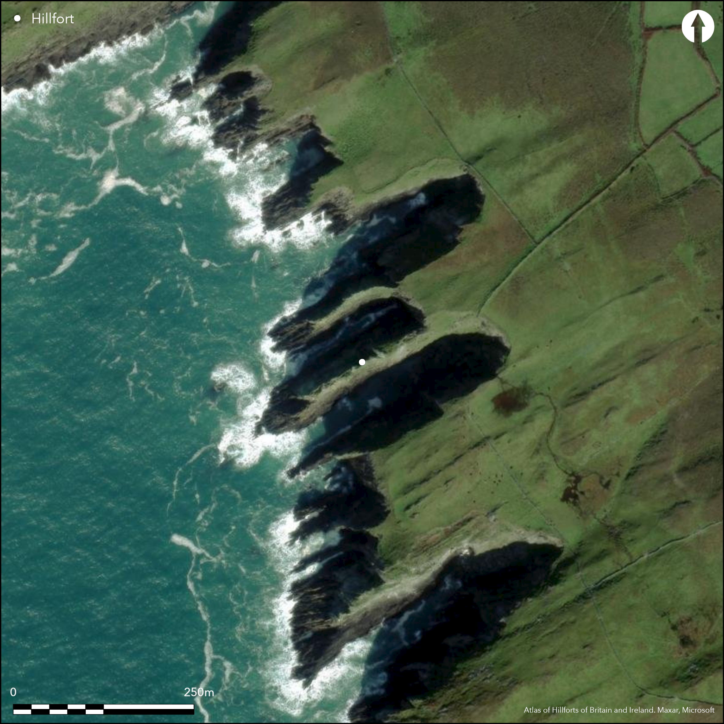
Satellite Imagery
Satellite Imagery
HER: Archaeological Survey of Ireland SMR Database CO153-014 (None)
NMR: CO 153 (None)
SM: None
NGR: None
X: 494274 Y: 520322 (IRENET95)
The promontory is situated on a rapidly eroding headland that projects SW from Cape Clear Island off the SW coast of Co. Cork at an altitude of 19m OD. Identified as 'Doonthomas' on first edition OS 6-inch map (1842). Westropp (1915, 253) observed that the enclosing elements consisted of a wall and a single ditch on the seaward side at the neck of the promontory. The wall was composed of thin slabs, four or five courses high which survived mainly on the S side at the edge of the ditch. He noted that he 'had rarely seen so appalling a wall of such wrecked and loose-looking rock.....ready to fall at a touch' (1915, 253). He also noted that the ditch had been recently filled by a mass of fallen rock. A circular hut was also recorded within the interior of the fort composed of regular slabs that were curved and well fitted. The doorway of the hut faced E and overall the structure measured '20 feet to 25 feet across' (Westropp 1915, 253). There is no visible surface trace of the ditch, wall or circular hut structure which have presumable been eroded by the sea. The promontory measures 130m from SW to NE by 21m transversely and survives as a narrow spine of rock, with no soil cover; eroding rapidly by sea.
Citizen Science: ✗
Reliability of Data: Confirmed
Reliability of Interpretation: Confirmed
X: -1059804 Y: 6696949 (EPSG: 3857)
Longitude: -9.520384411999476 Latitude: 51.42573302793982 (EPSG:4326)
Country: Republic of Ireland
Current County or Unitary Authority: Cork (Cape Clear)
Historic County: Cork
Current Parish/Community/Council/Townland: Ballyieragh North
While the headland is intact, there is no surface trace of wall or ditch described by Westropp in 1915. The headland is now a narrow neck of bare rock that continues to be eroded.
| Extant | ✗ |
| Cropmark | ✗ |
| Likely Destroyed | ✓ |
Promontory now a long, narrow spine of rock with no soil cover which is eroding rapidly.
| Woodland | ✗ |
| Commercial Forestry Plantation | ✗ |
| Parkland | ✗ |
| Pasture (Grazing) | ✗ |
| Arable | ✗ |
| Scrub/Bracken | ✗ |
| Bare Outcrop | ✗ |
| Heather/Moorland | ✗ |
| Heath | ✗ |
| Built-up | ✗ |
| Coastal Grassland | ✗ |
| Other | ✗ |
The site is situated on a rapidly eroding headland that projects SW from Cape Clear Island off the SW coast of Co. Cork.
| Contour Fort | ✗ |
| Partial Contour Fort | ✗ |
| Promontory Fort | ✓ |
| Hillslope Fort | ✗ |
| Level Terrain Fort | ✗ |
| Marsh Fort | ✗ |
| Multiple Enclosure Fort | ✗ |
| Hilltop | ✗ |
| Coastal Promontory | ✓ |
| Inland Promontory | ✗ |
| Valley Bottom | ✗ |
| Knoll/Hillock/Outcrop | ✗ |
| Ridge | ✗ |
| Cliff/Plateau-edge/Scarp | ✗ |
| Hillslope | ✗ |
| Lowland | ✗ |
| Spur | ✗ |
Dominant Topographic Feature: SW-facing promontory
| North | ✗ |
| Northeast | ✗ |
| East | ✗ |
| Southeast | ✗ |
| South | ✗ |
| Southwest | ✓ |
| West | ✗ |
| Northwest | ✗ |
| Level | ✗ |
Altitude: 19.0m
N/A
There is no dating available for the site
Reliability: D - None
| Pre 1200BC | ✗ |
| 1200BC - 800BC | ✗ |
| 800BC - 400BC | ✗ |
| 400BC - AD50 | ✗ |
| AD50 - AD400 | ✗ |
| AD400 - AD 800 | ✗ |
| Post AD800 | ✗ |
| Unknown | ✓ |
| Pre Hillfort: | None |
| Post Hillfort: | None |
Identified as 'Doonthomas' on first edition OS six-inch map (1842). Recorded as potential promontory by Thomas Westropp in 1915 where he describes the remains of a stone wall and 'fosse' on the seaward side, at the neck of the promontory. The site was visited and inspected by the Cork Archaeological Survey in 1984 for the compilation of the Archaeological Inventory of West Cork (Power et al. 1992). There was no visible surface trace of the wall and ditch or the interior structure recorded by Westropp.
| 1st Identified Map Depiction (1842): | OS six-inch mapping |
| 1st Identified Written Reference (1915): | Westropp |
| Other (1984): | Cork Archaeological Survey |
A circular hut structure was recorded by Westropp in the interior of the fort in the early twentieth century. It was composed of regular slabs that were well fitted and the remains of a doorway also survived. He noted that the structure measured 20 feet by 25 feet across (1915, 253). This structure no longer survives.
None
| None | ✓ |
| Spring | ✗ |
| Stream | ✗ |
| Pool | ✗ |
| Flush | ✗ |
| Well | ✗ |
| Other | ✗ |
The structure recorded by Westropp no longer survives
| No Known Features | ✗ |
| Round Stone Structures | ✓ |
| Rectangular Stone Structures | ✗ |
| Curvilinear Platforms | ✗ |
| Other Roundhouse Evidence | ✗ |
| Pits | ✗ |
| Quarry Hollows | ✗ |
| Other | ✗ |
None
| No Known Excavation | ✓ |
| Pits | ✗ |
| Postholes | ✗ |
| Roundhouses | ✗ |
| Rectangular Structures | ✗ |
| Roads/Tracks | ✗ |
| Quarry Hollows | ✗ |
| Other | ✗ |
| Nothing Found | ✗ |
None
| No Known Geophysics | ✓ |
| Pits | ✗ |
| Roundhouses | ✗ |
| Rectangular Structures | ✗ |
| Roads/Tracks | ✗ |
| Quarry Hollows | ✗ |
| Other | ✗ |
| Nothing Found | ✗ |
None
| No Known Finds | ✓ |
| Pottery | ✗ |
| Metal | ✗ |
| Metalworking | ✗ |
| Human Bones | ✗ |
| Animal Bones | ✗ |
| Lithics | ✗ |
| Environmental | ✗ |
| Other | ✗ |
NO APPARENT FEATURES
| APs Not Checked | ✗ |
| None | ✓ |
| Roundhouses | ✗ |
| Rectangular Structures | ✗ |
| Pits | ✗ |
| Postholes | ✗ |
| Roads/Tracks | ✗ |
| Other | ✗ |
There are no recorded entrances to the site. Presumably the fort was accessed through the narrow neck of land which connects the promontory to the island.
| 0: | There are no recorded entrances to the site. |
| 2: | None |
Guard Chambers: ✗
Chevaux de Frise: ✗
Westropp recorded a ditch with a stone wall of thin slabs four or five courses high. The wall and ditch have been completely eroded by the sea.
| Area 1: | 0.28ha. |
| Total: | 0.28ha. |
Total Footprint Area: 0.28ha.
None
| ✗ | None |
| ✗ | Remains of a wall and ditch recorded by Westropp on the NE and S sides. No longer survives |
| NE Quadrant: | 1 |
| SE Quadrant: | 0 |
| SW Quadrant: | 0 |
| NW Quadrant: | 0 |
| Total: | 1 |
| Partial Univallate | ✓ |
| Univallate | ✗ |
| Partial Bivallate | ✗ |
| Bivallate | ✗ |
| Partial Multivallate | ✗ |
| Multivallate | ✗ |
| Unknown | ✗ |
| Partial Univallate | ✗ |
| Univallate | ✗ |
| Partial Bivallate | ✗ |
| Bivallate | ✗ |
| Partial Multivallate | ✗ |
| Multivallate | ✗ |
Remnants of wall recorded by Westropp on the NE and S sides, though this no longer survives.
| None | ✗ |
| Earthen Bank | ✗ |
| Stone Wall | ✓ |
| Rubble | ✗ |
| Wall-walk | ✗ |
| Evidence of Timber | ✗ |
| Vitrification | ✗ |
| Other Burning | ✗ |
| Palisade | ✗ |
| Counter Scarp Bank | ✗ |
| Berm | ✗ |
| Unfinished | ✗ |
| Other | ✗ |
None
| None | ✗ |
| Earthen Bank | ✗ |
| Stone Wall | ✗ |
| Murus Duplex | ✗ |
| Timber-framed | ✗ |
| Timber-laced | ✗ |
| Vitrification | ✗ |
| Other Burning | ✗ |
| Palisade | ✗ |
| Counter Scarp Bank | ✗ |
| Berm | ✗ |
| Unfinished | ✗ |
| No Known Excavation | ✓ |
| Other | ✗ |
| ✗ | None |
| ✓ | Westropp recorded the remains of a ditch on on the seaward side at the neck of the promontory. He noted that it had been partially filled in by fallen rocks. This ditch no longer survives. |
Number of Ditches: 1
| ✗ | None |
Power, D., Byrne, E., Egan, U., Lane, S., and Sleeman, M. 1992. Archaeological Inventory of County Cork Volume 1: West Cork, 126-130. The stationary Office, Dublin.
Westropp, T.J. 1915. Fortified headlands and castles in western County Cork. Proceedings of the Royal Irish Academy 32C, 249-86.
Atlas of Hillforts:
Wikidata:
This work is licensed under CC BY-SA 4.0

 and should be cited as:
Lock, Gary and Ralston, Ian. 2024. Atlas of Hillforts of Britain and Ireland. Available at: https://hillforts.arch.ox.ac.uk
Document Version 1.1