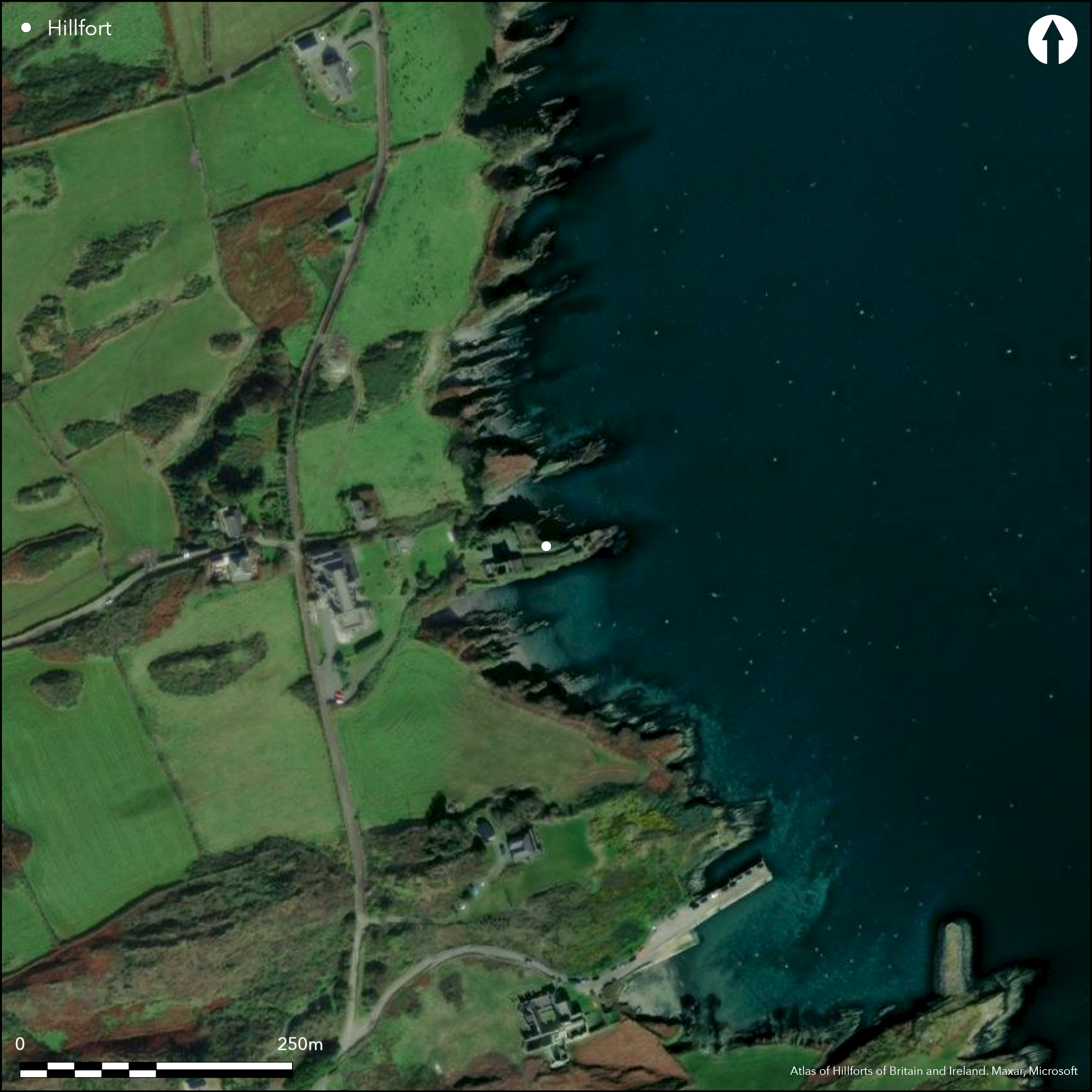
Satellite Imagery
Satellite Imagery
HER: Archaeological Survey of Ireland SMR Database CO149-018001 (None)
NMR: CO 149 (None)
SM: None
NGR: None
X: 502737 Y: 526036 (IRENET95)
The sub-rectangular headland (The Platform) is situated on the E side of Sherkin Island on the SW coast of Co. Cork. It projects W into Baltimore Bay at an altitude of 11m OD. Depicted as the site of a castle on the first edition OS six-inch map (1842), most of the promontory is occupied by the remains of Late Medieval fortifications (CO149-018002). The castle is locally referred to as either 'Dunalong (the ships fort)', 'the Garrison' or the 'Platform'. Westropp (1914, 108) noted a silted-up ditch in front of the curtain wall of the W. This ran across the neck of the promontory and was evident in the section face at either end. The ditch section, however, is now no longer visible due to overgrowth and erosion. The interior is occupied by the later fortifications and is much overgrown.
Citizen Science: ✗
Reliability of Data: Confirmed
Reliability of Interpretation: Confirmed
X: -1046436 Y: 6706393 (EPSG: 3857)
Longitude: -9.400294045930275 Latitude: 51.4786005882273 (EPSG:4326)
Country: Republic of Ireland
Current County or Unitary Authority: Cork (Sherkin Island)
Historic County: Cork
Current Parish/Community/Council/Townland: Farranacoush
While much of the remains of the later fortification survive, the remnants of the earlier occupation of the headland are no longer visible due to overgrowth and erosion.
| Extant | ✓ |
| Cropmark | ✗ |
| Likely Destroyed | ✗ |
The promontory is overgrown and the ditch section is no longer visible due to overgrowth and erosion.
| Woodland | ✗ |
| Commercial Forestry Plantation | ✗ |
| Parkland | ✗ |
| Pasture (Grazing) | ✗ |
| Arable | ✗ |
| Scrub/Bracken | ✓ |
| Bare Outcrop | ✗ |
| Heather/Moorland | ✗ |
| Heath | ✗ |
| Built-up | ✗ |
| Coastal Grassland | ✗ |
| Other | ✗ |
The promontory is situated on the E side of Sherkin Island on the SW coast of Co. Cork at an altitude of 11m OD. The headland slopes gently E into Baltimore Harbour. The promontory is occupied by the remains of late medieval fortifications (CO149-018002).
| Contour Fort | ✗ |
| Partial Contour Fort | ✗ |
| Promontory Fort | ✓ |
| Hillslope Fort | ✗ |
| Level Terrain Fort | ✗ |
| Marsh Fort | ✗ |
| Multiple Enclosure Fort | ✗ |
| Hilltop | ✗ |
| Coastal Promontory | ✓ |
| Inland Promontory | ✗ |
| Valley Bottom | ✗ |
| Knoll/Hillock/Outcrop | ✗ |
| Ridge | ✗ |
| Cliff/Plateau-edge/Scarp | ✗ |
| Hillslope | ✗ |
| Lowland | ✗ |
| Spur | ✗ |
Dominant Topographic Feature: E-facing promontory
| North | ✗ |
| Northeast | ✗ |
| East | ✓ |
| Southeast | ✗ |
| South | ✗ |
| Southwest | ✗ |
| West | ✗ |
| Northwest | ✗ |
| Level | ✗ |
Altitude: 11.0m
N/A
Site not dated.
Reliability: D - None
| Pre 1200BC | ✗ |
| 1200BC - 800BC | ✗ |
| 800BC - 400BC | ✗ |
| 400BC - AD50 | ✗ |
| AD50 - AD400 | ✗ |
| AD400 - AD 800 | ✗ |
| Post AD800 | ✗ |
| Unknown | ✓ |
| Pre Hillfort: | None |
| Post Hillfort: | Headland occupied by Late Medieval fortifications consisting of tower house and sections of a bawn wall. Tower now covered by modern galvanised roof. Heavily modified and poorly preserved section of bawn wall indicates position of original gateway with ruined mural tower immediately to N. Castle of the O'Driscoll clan attacked by citizens of Waterford in 1537; garrisoned by Spanish in 1601 (Coleman 1925, 26-33) (Westropp 1914,108-11). |
The site is not depicted as an entrenched headland on any edition of the s-inch OS maps. First recorded by Westropp in the early twentieth century where he noted silted-up ditch, just in front (to W) of curtain wall, across the neck of the promontory (1914, 108). Subsequently surveyed by the Cork Archaeological Survey in 1987 when ditch section was no longer visible (Power et al. 1992, 128).
| 1st Identified Written Reference (1914): | Thomas Westropp |
| Other (1987): | Cork Archaeological Survey |
The recorded stone structures in the interior of the headland relate to the later fortification of the promontory during the Medieval period.
A well is recorded on the second edition OS map directly outside the promontory on the W side.
| None | ✓ |
| Spring | ✗ |
| Stream | ✗ |
| Pool | ✗ |
| Flush | ✗ |
| Well | ✗ |
| Other | ✗ |
These stone structures relate to later fortification of the headland.
| No Known Features | ✗ |
| Round Stone Structures | ✗ |
| Rectangular Stone Structures | ✓ |
| Curvilinear Platforms | ✗ |
| Other Roundhouse Evidence | ✗ |
| Pits | ✗ |
| Quarry Hollows | ✗ |
| Other | ✗ |
None
| No Known Excavation | ✓ |
| Pits | ✗ |
| Postholes | ✗ |
| Roundhouses | ✗ |
| Rectangular Structures | ✗ |
| Roads/Tracks | ✗ |
| Quarry Hollows | ✗ |
| Other | ✗ |
| Nothing Found | ✗ |
None
| No Known Geophysics | ✓ |
| Pits | ✗ |
| Roundhouses | ✗ |
| Rectangular Structures | ✗ |
| Roads/Tracks | ✗ |
| Quarry Hollows | ✗ |
| Other | ✗ |
| Nothing Found | ✗ |
None
| No Known Finds | ✓ |
| Pottery | ✗ |
| Metal | ✗ |
| Metalworking | ✗ |
| Human Bones | ✗ |
| Animal Bones | ✗ |
| Lithics | ✗ |
| Environmental | ✗ |
| Other | ✗ |
These stone structures relate to later fortification of the headland.
| APs Not Checked | ✗ |
| None | ✗ |
| Roundhouses | ✗ |
| Rectangular Structures | ✓ |
| Pits | ✗ |
| Postholes | ✗ |
| Roads/Tracks | ✗ |
| Other | ✗ |
Heavily modified and poorly preserved section of bawn wall indicates position of original gateway with ruined mural tower immediately to N. This entrance to the headland is related to the medieval occupation of the site. There are no recorded entrances relating to the earliest phase of activity.
| 0: | None |
| 2: | Only access is from across the neck on the W |
Guard Chambers: ✗
Chevaux de Frise: ✗
There are no recorded ramparts. Westropp (1914, 108) noted silted-up ditch, just in front (to W) of the curtain wall across neck of promontory, evident in section face at either end. The ditch section is no longer visible due to overgrowth and erosion.
| Area 1: | 0.24ha. |
| Total: | 0.24ha. |
Total Footprint Area: 0.24ha.
None
| ✗ | None |
| ✗ | Only a silted ditch noted across the neck on the W |
| NE Quadrant: | 0 |
| SE Quadrant: | 0 |
| SW Quadrant: | 1 |
| NW Quadrant: | 0 |
| Total: | 1 |
| Partial Univallate | ✓ |
| Univallate | ✗ |
| Partial Bivallate | ✗ |
| Bivallate | ✗ |
| Partial Multivallate | ✗ |
| Multivallate | ✗ |
| Unknown | ✗ |
| Partial Univallate | ✗ |
| Univallate | ✗ |
| Partial Bivallate | ✗ |
| Bivallate | ✗ |
| Partial Multivallate | ✗ |
| Multivallate | ✗ |
None
| None | ✓ |
| Earthen Bank | ✗ |
| Stone Wall | ✗ |
| Rubble | ✗ |
| Wall-walk | ✗ |
| Evidence of Timber | ✗ |
| Vitrification | ✗ |
| Other Burning | ✗ |
| Palisade | ✗ |
| Counter Scarp Bank | ✗ |
| Berm | ✗ |
| Unfinished | ✗ |
| Other | ✗ |
None
| None | ✗ |
| Earthen Bank | ✗ |
| Stone Wall | ✗ |
| Murus Duplex | ✗ |
| Timber-framed | ✗ |
| Timber-laced | ✗ |
| Vitrification | ✗ |
| Other Burning | ✗ |
| Palisade | ✗ |
| Counter Scarp Bank | ✗ |
| Berm | ✗ |
| Unfinished | ✗ |
| No Known Excavation | ✓ |
| Other | ✗ |
| ✗ | None |
| ✓ | None |
Number of Ditches: 1
| ✗ | None |
Power, D., Byrne, E., Egan, U., Lane, S., and Sleeman, M. 1992. Archaeological Inventory of County Cork Volume 1: West Cork, 126-130. The stationary Office, Dublin.
Westropp, T.J. 1914. Fortified headlands and castles on the south coast of Munster. Proceedings of the Royal Irish Academy 32C, 104-105.
Atlas of Hillforts:
Wikidata:
This work is licensed under CC BY-SA 4.0

 and should be cited as:
Lock, Gary and Ralston, Ian. 2024. Atlas of Hillforts of Britain and Ireland. Available at: https://hillforts.arch.ox.ac.uk
Document Version 1.1