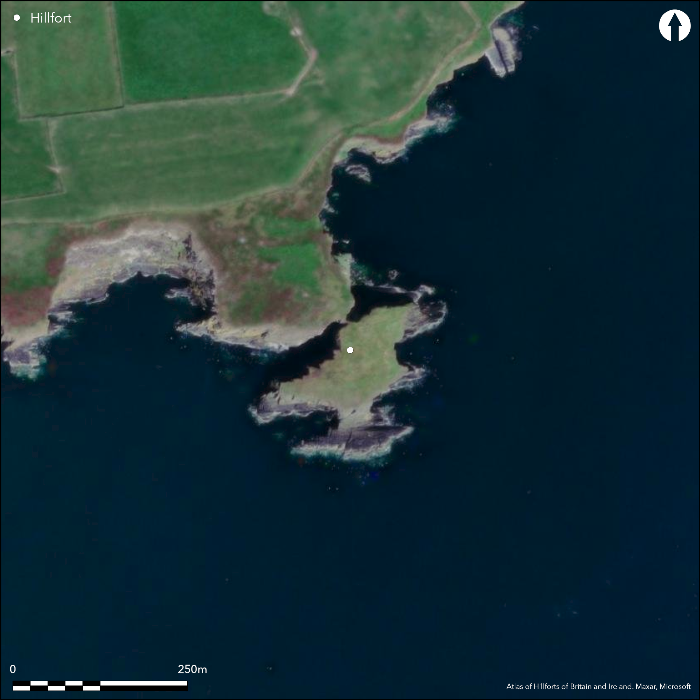
Satellite Imagery
Satellite Imagery
HER: Archaeological Survey of Ireland SMR Database CO125-019 (None)
NMR: CO 125 (None)
SM: None
NGR: None
X: 570342 Y: 548510 (IRENET95)
The headland named ÇLittle Doon' on the first edition OS six-inch map (1842), is located c. 4km SW of Nohval Village and c. 5.1km SE of Kinsale town in S Co. Cork. It can be described as an irregular landmass (c. 120m NE-SW x c. 70m NW-SE) of approximately 0.99ha, projecting SE into the Atlantic at an elevation of 12m OD. It is connected to the mainland by a narrow neck which is 5m in length and 2m in width, and a section exposed by erosion suggests the ground here was raised to the same level as the promontory and mainland. The ground to the W of the entrance, however, has collapsed. The interior slopes gradually to the S and according to Westropp (1914, 108) there were 'clear foundations of a house just inside to the right (west) of the entrance, and what is possibly another foundation to the left'. There are no indications of earthworks which can be interpreted as enclosing elements.
Citizen Science: ✗
Reliability of Data: Unconfirmed
Reliability of Interpretation: Unconfirmed
X: -938306 Y: 6743945 (EPSG: 3857)
Longitude: -8.428946295150475 Latitude: 51.68821029707623 (EPSG:4326)
Country: Republic of Ireland
Current County or Unitary Authority: Cork
Historic County: Cork
Current Parish/Community/Council/Townland: Kinure
None
| Extant | ✗ |
| Cropmark | ✗ |
| Likely Destroyed | ✓ |
None
| Woodland | ✗ |
| Commercial Forestry Plantation | ✗ |
| Parkland | ✗ |
| Pasture (Grazing) | ✗ |
| Arable | ✗ |
| Scrub/Bracken | ✗ |
| Bare Outcrop | ✗ |
| Heather/Moorland | ✗ |
| Heath | ✗ |
| Built-up | ✗ |
| Coastal Grassland | ✓ |
| Other | ✗ |
Coastal promontory composed of an irregular landmass of approximately 0.99ha, projecting SE into Atlantic. It is connected to the mainland by a narrow neck.
| Contour Fort | ✗ |
| Partial Contour Fort | ✗ |
| Promontory Fort | ✓ |
| Hillslope Fort | ✗ |
| Level Terrain Fort | ✗ |
| Marsh Fort | ✗ |
| Multiple Enclosure Fort | ✗ |
| Hilltop | ✗ |
| Coastal Promontory | ✓ |
| Inland Promontory | ✗ |
| Valley Bottom | ✗ |
| Knoll/Hillock/Outcrop | ✗ |
| Ridge | ✗ |
| Cliff/Plateau-edge/Scarp | ✗ |
| Hillslope | ✗ |
| Lowland | ✗ |
| Spur | ✗ |
Dominant Topographic Feature: It is overlooked to the N by a series of low hills.
| North | ✗ |
| Northeast | ✗ |
| East | ✗ |
| Southeast | ✗ |
| South | ✓ |
| Southwest | ✗ |
| West | ✗ |
| Northwest | ✗ |
| Level | ✗ |
Altitude: 12.0m
N/A
None
Reliability: D - None
| Pre 1200BC | ✗ |
| 1200BC - 800BC | ✗ |
| 800BC - 400BC | ✗ |
| 400BC - AD50 | ✗ |
| AD50 - AD400 | ✗ |
| AD400 - AD 800 | ✗ |
| Post AD800 | ✗ |
| Unknown | ✓ |
| Pre Hillfort: | None |
| Post Hillfort: | None |
Site depicted as 'little Doon (fort)' on first edition (1842) six-inch OS map. Headland described by Westropp in 1914 who notes foundations of hut-sites immediately inside the entrance to the site. These were no longer visible when surveyed by Cork Archaeological Survey in 1990.
| 1st Identified Map Depiction (1842): | OS six-inch mapping |
| 1st Identified Written Reference (1914): | Westropp |
| Earthwork Survey (1990): | Cork Archaeological Survey |
Westropp described foundations of two possible hut-sites immediately inside the interior to the right. These are no longer visible due to erosion in that area.
None
| None | ✓ |
| Spring | ✗ |
| Stream | ✗ |
| Pool | ✗ |
| Flush | ✗ |
| Well | ✗ |
| Other | ✗ |
According to Westropp (1914, 108) 'clear foundations of a house just inside to the right (west) of the entrance, and what is possibly another foundation to the left'.
| No Known Features | ✗ |
| Round Stone Structures | ✗ |
| Rectangular Stone Structures | ✗ |
| Curvilinear Platforms | ✗ |
| Other Roundhouse Evidence | ✗ |
| Pits | ✗ |
| Quarry Hollows | ✗ |
| Other | ✓ |
None
| No Known Excavation | ✓ |
| Pits | ✗ |
| Postholes | ✗ |
| Roundhouses | ✗ |
| Rectangular Structures | ✗ |
| Roads/Tracks | ✗ |
| Quarry Hollows | ✗ |
| Other | ✗ |
| Nothing Found | ✗ |
None
| No Known Geophysics | ✓ |
| Pits | ✗ |
| Roundhouses | ✗ |
| Rectangular Structures | ✗ |
| Roads/Tracks | ✗ |
| Quarry Hollows | ✗ |
| Other | ✗ |
| Nothing Found | ✗ |
None
| No Known Finds | ✓ |
| Pottery | ✗ |
| Metal | ✗ |
| Metalworking | ✗ |
| Human Bones | ✗ |
| Animal Bones | ✗ |
| Lithics | ✗ |
| Environmental | ✗ |
| Other | ✗ |
NO APPARENT FEATURES
| APs Not Checked | ✗ |
| None | ✓ |
| Roundhouses | ✗ |
| Rectangular Structures | ✗ |
| Pits | ✗ |
| Postholes | ✗ |
| Roads/Tracks | ✗ |
| Other | ✗ |
Site is accessed by a narrow neck connected to the mainland. It is not associated with any banks, ditches or stone-work. This is an original entrance to the site that does not seem to have been defended.
| 0: | None |
| 2: | Site is accessed by a narrow neck connected to the mainland. It is not associated with any banks, ditches or stone-work. |
Guard Chambers: ✗
Chevaux de Frise: ✗
There are no recorded banks, ramparts or ditches.
| Area 1: | 0.99ha. |
| Total: | 0.99ha. |
Total Footprint Area: 0.99ha.
None
| ✗ | None |
| ✗ | None |
| NE Quadrant: | 0 |
| SE Quadrant: | 0 |
| SW Quadrant: | 0 |
| NW Quadrant: | 0 |
| Total: | 0 |
| Partial Univallate | ✗ |
| Univallate | ✗ |
| Partial Bivallate | ✗ |
| Bivallate | ✗ |
| Partial Multivallate | ✗ |
| Multivallate | ✗ |
| Unknown | ✓ |
| Partial Univallate | ✗ |
| Univallate | ✗ |
| Partial Bivallate | ✗ |
| Bivallate | ✗ |
| Partial Multivallate | ✗ |
| Multivallate | ✗ |
None
| None | ✓ |
| Earthen Bank | ✗ |
| Stone Wall | ✗ |
| Rubble | ✗ |
| Wall-walk | ✗ |
| Evidence of Timber | ✗ |
| Vitrification | ✗ |
| Other Burning | ✗ |
| Palisade | ✗ |
| Counter Scarp Bank | ✗ |
| Berm | ✗ |
| Unfinished | ✗ |
| Other | ✗ |
None
| None | ✗ |
| Earthen Bank | ✗ |
| Stone Wall | ✗ |
| Murus Duplex | ✗ |
| Timber-framed | ✗ |
| Timber-laced | ✗ |
| Vitrification | ✗ |
| Other Burning | ✗ |
| Palisade | ✗ |
| Counter Scarp Bank | ✗ |
| Berm | ✗ |
| Unfinished | ✗ |
| No Known Excavation | ✓ |
| Other | ✗ |
| ✗ | None |
| ✗ | None |
Number of Ditches: 0
| ✗ | None |
Power, D., Byrne, E., Egan, U., Lane, S., and Sleeman, M. 1994. Archaeological Inventory of County Cork Volume 2: East and South Cork, 64-5. The stationary Office, Dublin.
Westropp, T.J. 1914. Fortified headlands and castles on the south coast of Munster. Proceedings of the Royal Irish Academy 32C, 104-105.
Atlas of Hillforts:
Wikidata:
This work is licensed under CC BY-SA 4.0

 and should be cited as:
Lock, Gary and Ralston, Ian. 2024. Atlas of Hillforts of Britain and Ireland. Available at: https://hillforts.arch.ox.ac.uk
Document Version 1.1