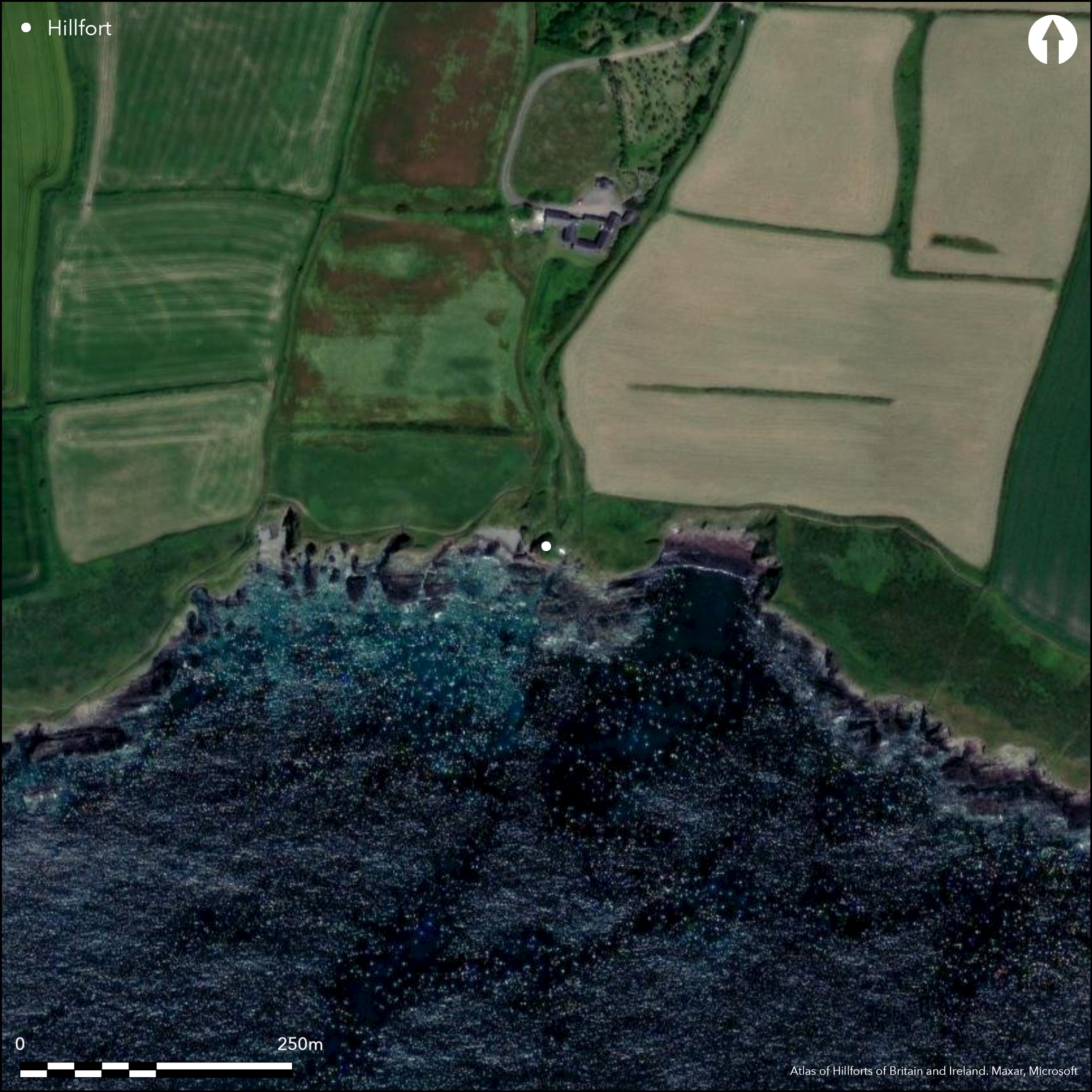
Satellite Imagery
Satellite Imagery
HER: Archaeological Survey of Ireland SMR Database CO089-054 (None)
NMR: CO 089 (None)
SM: None
NGR: None
X: 597899 Y: 563098 (IRENET95)
The site is located c.1.3km SE of Ballycotton village in the townland of Ballytrasna, E Cork. It has been described as a tower-like platform barely projecting S from the mainland, with almost perpendicular sides revetted with good masonry. It is at an elevation of 11m OD. Westropp (1914, 107), who visited the site in the early twentieth century and noted that the site was 'a long drift spur between two streams with the neck only 12 feet wide and the platform of hard earth rose 10 or 12 feet above it'. He observed that the whole was about 35 feet wide and 50 feet long'. The promontory has suffered significant damage from coastal erosion, surviving today as a free-standing island (c.16m N-S; c. 22m E-W). A 1m high earthen bank is visible on the landward side (N), with a possible ditch and external bank on the seaward side (S) (Power et al. 1994, 64). There are no recorded hut-sites or other features.
Citizen Science: ✗
Reliability of Data: Confirmed
Reliability of Interpretation: Confirmed
X: -893948 Y: 6767667 (EPSG: 3857)
Longitude: -8.03047554502483 Latitude: 51.820126170164464 (EPSG:4326)
Country: Republic of Ireland
Current County or Unitary Authority: Cork
Historic County: Cork
Current Parish/Community/Council/Townland: Ballytrasna
None
| Extant | ✓ |
| Cropmark | ✗ |
| Likely Destroyed | ✗ |
None
| Woodland | ✗ |
| Commercial Forestry Plantation | ✗ |
| Parkland | ✗ |
| Pasture (Grazing) | ✓ |
| Arable | ✗ |
| Scrub/Bracken | ✗ |
| Bare Outcrop | ✗ |
| Heather/Moorland | ✗ |
| Heath | ✗ |
| Built-up | ✗ |
| Coastal Grassland | ✗ |
| Other | ✗ |
Promontory can be described as a tower-like platform barely projecting S from the mainland with almost perpendicular sides, and revetted with good masonry.
| Contour Fort | ✗ |
| Partial Contour Fort | ✗ |
| Promontory Fort | ✓ |
| Hillslope Fort | ✗ |
| Level Terrain Fort | ✗ |
| Marsh Fort | ✗ |
| Multiple Enclosure Fort | ✗ |
| Hilltop | ✗ |
| Coastal Promontory | ✓ |
| Inland Promontory | ✗ |
| Valley Bottom | ✗ |
| Knoll/Hillock/Outcrop | ✗ |
| Ridge | ✗ |
| Cliff/Plateau-edge/Scarp | ✗ |
| Hillslope | ✗ |
| Lowland | ✗ |
| Spur | ✗ |
Dominant Topographic Feature: S-facing promontory
| North | ✗ |
| Northeast | ✗ |
| East | ✗ |
| Southeast | ✗ |
| South | ✓ |
| Southwest | ✗ |
| West | ✗ |
| Northwest | ✗ |
| Level | ✗ |
Altitude: 11.0m
N/A
There is no dating available for the site
Reliability: D - None
| Pre 1200BC | ✗ |
| 1200BC - 800BC | ✗ |
| 800BC - 400BC | ✗ |
| 400BC - AD50 | ✗ |
| AD50 - AD400 | ✗ |
| AD400 - AD 800 | ✗ |
| Post AD800 | ✗ |
| Unknown | ✓ |
| Pre Hillfort: | None |
| Post Hillfort: | None |
The site is not shown on any edition of the 6-inch OS maps. Described by Westropp in the early twentieth century as a 'long drift-spur between two streams' (1914, 107). Much of the site had been badly eroded by the sea when surveyed by the Cork Archaeological Survey in 1991. Some of the defences remain.
| 1st Identified Written Reference (1914): | Westropp |
| Earthwork Survey (1991): | Cork Archaeological Survey |
There are no recorded features within the interior of the site
A well is depicted on the second edition 25-inch OS map c. 160m to the N of the promontory
| None | ✓ |
| Spring | ✗ |
| Stream | ✗ |
| Pool | ✗ |
| Flush | ✗ |
| Well | ✗ |
| Other | ✗ |
None
| No Known Features | ✓ |
| Round Stone Structures | ✗ |
| Rectangular Stone Structures | ✗ |
| Curvilinear Platforms | ✗ |
| Other Roundhouse Evidence | ✗ |
| Pits | ✗ |
| Quarry Hollows | ✗ |
| Other | ✗ |
None
| No Known Excavation | ✓ |
| Pits | ✗ |
| Postholes | ✗ |
| Roundhouses | ✗ |
| Rectangular Structures | ✗ |
| Roads/Tracks | ✗ |
| Quarry Hollows | ✗ |
| Other | ✗ |
| Nothing Found | ✗ |
None
| No Known Geophysics | ✓ |
| Pits | ✗ |
| Roundhouses | ✗ |
| Rectangular Structures | ✗ |
| Roads/Tracks | ✗ |
| Quarry Hollows | ✗ |
| Other | ✗ |
| Nothing Found | ✗ |
None
| No Known Finds | ✓ |
| Pottery | ✗ |
| Metal | ✗ |
| Metalworking | ✗ |
| Human Bones | ✗ |
| Animal Bones | ✗ |
| Lithics | ✗ |
| Environmental | ✗ |
| Other | ✗ |
NO APPARENT FEATURES
| APs Not Checked | ✗ |
| None | ✓ |
| Roundhouses | ✗ |
| Rectangular Structures | ✗ |
| Pits | ✗ |
| Postholes | ✗ |
| Roads/Tracks | ✗ |
| Other | ✗ |
The site is accessed through the neck of the headland to a 'tower-like platform' (Westropp 1914, 107). There are no formal entrances through the banks.
| 0: | None |
| 2: | None |
Guard Chambers: ✗
Chevaux de Frise: ✗
A 1m high earthen bank is visible on the landward side (N) with a possible ditch and external bank on the S
| Area 1: | 0.07ha. |
| Total: | 0.07ha. |
Total Footprint Area: 0.07ha.
None
| ✗ | None |
| ✗ | None |
| NE Quadrant: | 1 |
| SE Quadrant: | 0 |
| SW Quadrant: | 1 |
| NW Quadrant: | 0 |
| Total: | 1 |
| Partial Univallate | ✓ |
| Univallate | ✗ |
| Partial Bivallate | ✗ |
| Bivallate | ✗ |
| Partial Multivallate | ✗ |
| Multivallate | ✗ |
| Unknown | ✗ |
| Partial Univallate | ✗ |
| Univallate | ✗ |
| Partial Bivallate | ✗ |
| Bivallate | ✗ |
| Partial Multivallate | ✗ |
| Multivallate | ✗ |
None
| None | ✗ |
| Earthen Bank | ✓ |
| Stone Wall | ✗ |
| Rubble | ✗ |
| Wall-walk | ✗ |
| Evidence of Timber | ✗ |
| Vitrification | ✗ |
| Other Burning | ✗ |
| Palisade | ✗ |
| Counter Scarp Bank | ✗ |
| Berm | ✗ |
| Unfinished | ✗ |
| Other | ✗ |
None
| None | ✗ |
| Earthen Bank | ✗ |
| Stone Wall | ✗ |
| Murus Duplex | ✗ |
| Timber-framed | ✗ |
| Timber-laced | ✗ |
| Vitrification | ✗ |
| Other Burning | ✗ |
| Palisade | ✗ |
| Counter Scarp Bank | ✗ |
| Berm | ✗ |
| Unfinished | ✗ |
| No Known Excavation | ✓ |
| Other | ✗ |
| ✗ | None |
| ✓ | None |
Number of Ditches: 1
| ✗ | None |
Power, D., Byrne, E., Egan, U., Lane, S., and Sleeman, M. 1994. Archaeological Inventory of County Cork Volume 2: East and South Cork, 64-5. The stationary Office, Dublin.
Westropp, T.J. 1914. Fortified headlands and castles on the south coast of Munster. Proceedings of the Royal Irish Academy 32C, 104-105.
Atlas of Hillforts:
Wikidata:
This work is licensed under CC BY-SA 4.0

 and should be cited as:
Lock, Gary and Ralston, Ian. 2024. Atlas of Hillforts of Britain and Ireland. Available at: https://hillforts.arch.ox.ac.uk
Document Version 1.1