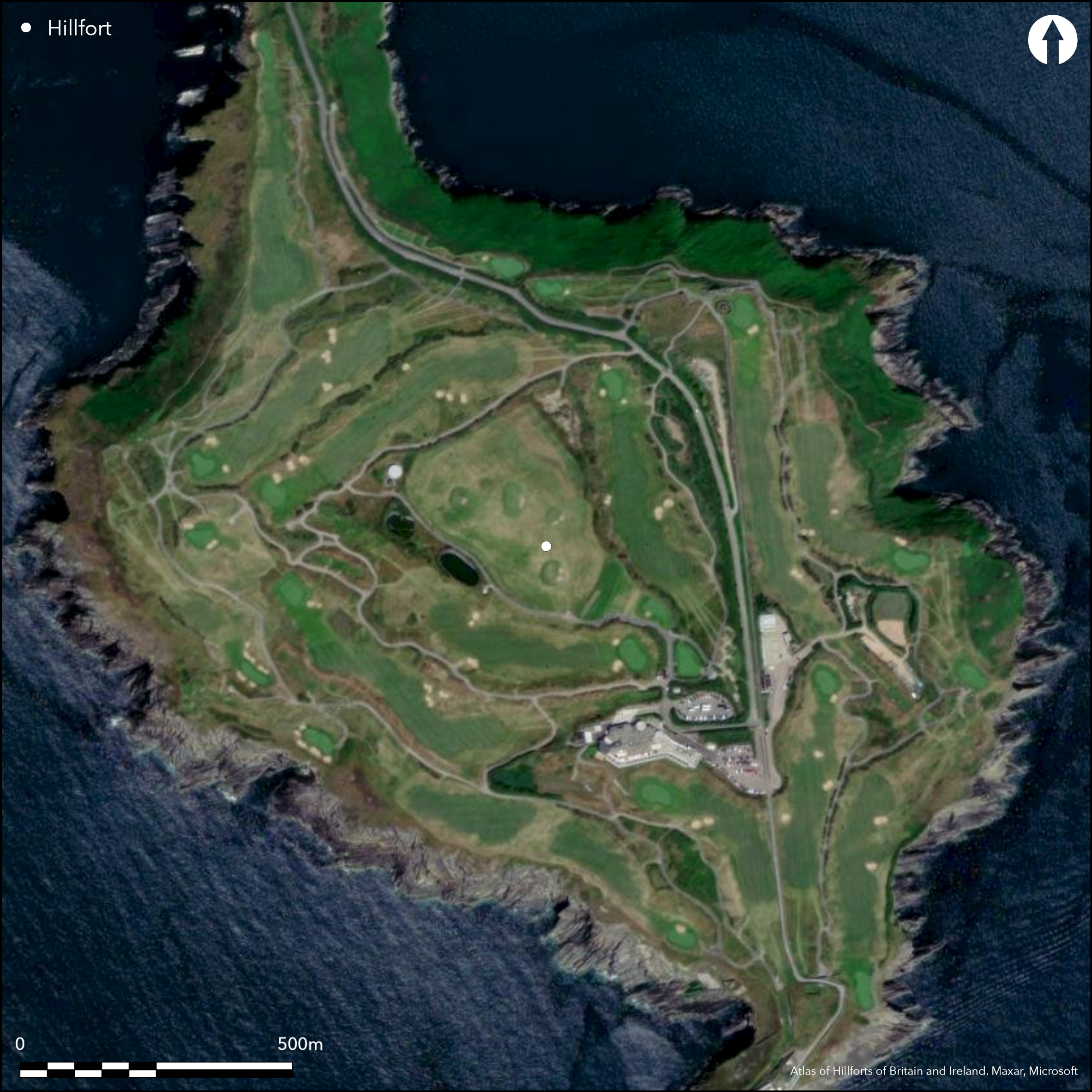
Satellite Imagery
Satellite Imagery
HER: Archaeological Survey of Ireland SMR Database CO137A001001 (None)
NMR: CO 137 (None)
SM: None
NGR: None
X: 562823 Y: 539914 (IRENET95)
This promontory is situated on the S coast of Co. Cork at the 'Old Head of Kinsale' between Courtmacsherry Bay and Kinsale Harbour, c. 6km SE of Ballinspittle village. Depicted as 'Downmacpatrick or the Old Head' on the first edition OS six-inch map (1840). Early historical references to D–n Cermna on the Old Head are documented by O'Rahilly (1939,16-20) who identifies it as an important Pre-Christian settlement,one of the two main strongholds of an Iron Age tribe known as the Ñrainn (Iverni). It can be described as an oval headland of c.84 ha connected to the mainland via a narrow neck, across which are the remains of a fifteenth century stone built fortification composed of a tower house and curtain wall (118m long) fronted by a substantial rock-cut ditch c. 6m wide and 2.4m deep (Westropp 1914, 120; Power et al. 1994). An entrance gateway is recorded through the curtain wall, accessed via a modern road. Though the masonry defence is evidently late-medieval in date, Westropp suggested the impressive external ditch 'may very probably be a remnant of the earlier promontory fort' (Westropp 1914, 122); this hypothesis is now contradicted by excavation (below). Although no apparent traces of prehistoric habitation are evident on the headland itself, many features such as hut-sites were visible before it was reclaimed and ploughed in the 1970. Prior to the development of a golf course on the headland during the 1990s archaeological monitoring, excavation and geophysical prospection was undertaken in selective areas of the promontory in order to prevent accidental damage to the buried archaeological features. This work showed Çlittle of archaeological interest' and most anomalies were of geological rather than archaeological origin. A rectangular enclosure with traces of internal huts-structures on the SW side of the promontory was excluded from the development and fenced off (Cleary 2001, 10). The excavation of the site was confined to the area around the entrance with two trenches excavated across the outer ditch on the N side of the castle. The investigation concluded that the ditch located outside and to the N of the castle was probably cut at the same time as the medieval fortifications were constructed (Cleary 2001, 12). The depositional sequence of medieval dump material related to the castle's occupation appeared to be continuous and there was no evidence for any intermediary sod layers indicating phases of regeneration. It was apparent to Cleary that the infilling of the ditch was relatively continuous over a short period of time with no evidence of re-cutting or enlargement from an earlier feature. A radiocarbon sample from a shell recovered in the lower fill of the ditch is dated to AD 1482-1653 (ibid., 13). The headland has been completely redeveloped as a golf course.
Citizen Science: ✗
Reliability of Data: Confirmed
Reliability of Interpretation: Unconfirmed
X: -950310 Y: 6730002 (EPSG: 3857)
Longitude: -8.536776228744868 Latitude: 51.61049241011633 (EPSG:4326)
Country: Republic of Ireland
Current County or Unitary Authority: Cork
Historic County: Cork
Current Parish/Community/Council/Townland: Downmacpatrick
The defences recorded at the neck of the promontory survive intact.
| Extant | ✓ |
| Cropmark | ✗ |
| Likely Destroyed | ✗ |
Golf course
| Woodland | ✗ |
| Commercial Forestry Plantation | ✗ |
| Parkland | ✓ |
| Pasture (Grazing) | ✗ |
| Arable | ✗ |
| Scrub/Bracken | ✗ |
| Bare Outcrop | ✗ |
| Heather/Moorland | ✗ |
| Heath | ✗ |
| Built-up | ✓ |
| Coastal Grassland | ✗ |
| Other | ✗ |
It can be described as an oval headland of c.84 ha projecting SE into Courtmacsherry Bay at an altitude of 50m OD and connected to the mainland via a narrow neck on the N, across which are the remains of a fifteenth century stone built fortification composed of a tower house and curtain wall (118m long) in line with a substantial rock-cut ditch.
| Contour Fort | ✗ |
| Partial Contour Fort | ✗ |
| Promontory Fort | ✓ |
| Hillslope Fort | ✗ |
| Level Terrain Fort | ✗ |
| Marsh Fort | ✗ |
| Multiple Enclosure Fort | ✗ |
| Hilltop | ✗ |
| Coastal Promontory | ✓ |
| Inland Promontory | ✗ |
| Valley Bottom | ✗ |
| Knoll/Hillock/Outcrop | ✗ |
| Ridge | ✗ |
| Cliff/Plateau-edge/Scarp | ✗ |
| Hillslope | ✗ |
| Lowland | ✗ |
| Spur | ✗ |
Dominant Topographic Feature: SE-facing promontory
| North | ✗ |
| Northeast | ✗ |
| East | ✗ |
| Southeast | ✗ |
| South | ✗ |
| Southwest | ✗ |
| West | ✗ |
| Northwest | ✗ |
| Level | ✓ |
Altitude: 50.0m
N/A
Shell sample from the lower fill of the ditch 310±30 BP (GrN-22475; AD 1482-1653)
Reliability: C - Low
| Pre 1200BC | ✗ |
| 1200BC - 800BC | ✗ |
| 800BC - 400BC | ✗ |
| 400BC - AD50 | ✗ |
| AD50 - AD400 | ✗ |
| AD400 - AD 800 | ✗ |
| Post AD800 | ✓ |
| Unknown | ✗ |
| Pre Hillfort: | None |
| Post Hillfort: | None |
| Artefactual: | Wooden object of probable medieval date recovered from the ditch along with midden material including animal bone, shells, post medieval pottery and seventeenth century roof tiles. |
| C14: | shell sample from the ditch 310±30 BP (AD 1482-1653) |
Depicted as 'Downmacpatrick or the Old Head' on the first edition OS six-inch map (1840). Identified by O'Rahilly in 1939 as the site of D–n Cermna, one of the two strongholds of an Iron Age tribe known as the Iverni. Visited and surveyed by Thomas Westropp in 1914. Earthworks surveyed by Muiris de Buitl_ir in 1983 while the site was surveyed by the Cork Archaeological Survey in 1991 for the compilation of the Cork Archaeological Inventory (Power et al. 1994, 65). Archaeological monitoring of topsoil stripping was carried out in 1995 along with targeted geophysical prospection in advance of a golf course development. Excavation of the medieval defences conducted in 1996 (Cleary 2001).
| 1st Identified Map Depiction (1840): | OS six-inch mapping |
| 1st Identified Written Reference (1939): | O'Rahilly |
| Earthwork Survey (1983): | de Buitléir (National Monuments Service) |
| Earthwork Survey (1991): | Cork Archaeological Survey |
| Geophysical Survey (1995): | Stratascan |
| Excavation (1996): | Rose M. Cleary (Archaeological Services Unit UCC) |
Four hut-sites and an enclosure recorded by David Sweetman and Muiris de Buitl_ir of National Monuments Service in 1983 on the W side of the narrow neck of the promontory are now no longer evident (Hurley 2012). Noted by Cleary in 1996 (2001, 10). According to local information there were once stones on the E side of the promontory called 'Leaba Diarmuid' which translates as Diarmuid's bed. Not evident on the ground. Though no apparent traces of prehistoric habitation are evident on the headland itself, many features such as hut-sites were visible before the headland was reclaimed and ploughed in the 1970
None
| None | ✓ |
| Spring | ✗ |
| Stream | ✗ |
| Pool | ✗ |
| Flush | ✗ |
| Well | ✗ |
| Other | ✗ |
None
| No Known Features | ✓ |
| Round Stone Structures | ✗ |
| Rectangular Stone Structures | ✗ |
| Curvilinear Platforms | ✗ |
| Other Roundhouse Evidence | ✗ |
| Pits | ✗ |
| Quarry Hollows | ✗ |
| Other | ✗ |
None
| No Known Excavation | ✗ |
| Pits | ✗ |
| Postholes | ✗ |
| Roundhouses | ✗ |
| Rectangular Structures | ✗ |
| Roads/Tracks | ✗ |
| Quarry Hollows | ✗ |
| Other | ✗ |
| Nothing Found | ✓ |
Geological features
| No Known Geophysics | ✗ |
| Pits | ✗ |
| Roundhouses | ✗ |
| Rectangular Structures | ✗ |
| Roads/Tracks | ✗ |
| Quarry Hollows | ✗ |
| Other | ✗ |
| Nothing Found | ✓ |
Wooden object of probable medieval date recovered from the ditch along with midden material including animal bone, shells, post medieval pottery and seventeenth century roof tiles.
| No Known Finds | ✗ |
| Pottery | ✓ |
| Metal | ✗ |
| Metalworking | ✗ |
| Human Bones | ✗ |
| Animal Bones | ✓ |
| Lithics | ✗ |
| Environmental | ✓ |
| Other | ✓ |
According to local information there were once stones on the E side of the promontory called 'Leaba Diarmuid' which translates as Diarmuid's bed. A number of stones, which appear to be leaning and prostrate, are shown on an aerial photograph (Dr D.D.C. Pochin Mould, 16.03.1981), and may have been part of a megalithic structure. There is no visible trace of this possible structure at ground level.
| APs Not Checked | ✗ |
| None | ✗ |
| Roundhouses | ✗ |
| Rectangular Structures | ✗ |
| Pits | ✗ |
| Postholes | ✗ |
| Roads/Tracks | ✗ |
| Other | ✓ |
Access to the promontory in the medieval period was across a paved roadway which was reduced in recent times with a second metalled surface laid. Excavation of the entrance showed that the foundation of the curtain wall widened on the E side probably indicating that the gate was defended by a structure.
| 1: | None |
| 2: | The only access lies across the neck on the N |
Guard Chambers: ✗
Chevaux de Frise: ✗
It can be described as an oval headland of c.84 ha connected to the mainland via a narrow neck, across which are the remains of a fifteenth century stone built fortification composed of a tower house and curtain wall (118m long) in line with a substantial rock-cut ditch c. 6m wide and 2.4m deep (Westropp 1914, 120; Power et al. 1994). Excavation concluded that the ditch located outside and to the N of the castle was probably cut at the same time was the medieval fortifications were constructed (Cleary 2001, 12).
| Area 1: | 81.2ha. |
| Total: | 81.2ha. |
Total Footprint Area: 84.0ha.
None
| ✗ | None |
| ✗ | Medieval curtain wall; no earlier defensive line recorded |
| NE Quadrant: | 0 |
| SE Quadrant: | 0 |
| SW Quadrant: | 0 |
| NW Quadrant: | 0 |
| Total: | 0 |
| Partial Univallate | ✗ |
| Univallate | ✗ |
| Partial Bivallate | ✗ |
| Bivallate | ✗ |
| Partial Multivallate | ✗ |
| Multivallate | ✗ |
| Unknown | ✓ |
| Partial Univallate | ✗ |
| Univallate | ✗ |
| Partial Bivallate | ✗ |
| Bivallate | ✗ |
| Partial Multivallate | ✗ |
| Multivallate | ✗ |
Medieval curtain wall
| None | ✗ |
| Earthen Bank | ✗ |
| Stone Wall | ✗ |
| Rubble | ✗ |
| Wall-walk | ✗ |
| Evidence of Timber | ✗ |
| Vitrification | ✗ |
| Other Burning | ✗ |
| Palisade | ✗ |
| Counter Scarp Bank | ✗ |
| Berm | ✗ |
| Unfinished | ✗ |
| Other | ✓ |
Medieval in date
| None | ✗ |
| Earthen Bank | ✗ |
| Stone Wall | ✓ |
| Murus Duplex | ✗ |
| Timber-framed | ✗ |
| Timber-laced | ✗ |
| Vitrification | ✗ |
| Other Burning | ✗ |
| Palisade | ✗ |
| Counter Scarp Bank | ✗ |
| Berm | ✗ |
| Unfinished | ✗ |
| No Known Excavation | ✗ |
| Other | ✗ |
| ✗ | None |
| ✓ | Rock-cut ditch interpreted as medieval in date contemporary with the tower-house and curtain wall. |
Number of Ditches: 1
| ✗ | None |
Cleary, R.M 2001. Old Head, Kinsale, Co. Cork. Journal of the Cork Historical and Archaeological Society 106, 1-20.
Hurley, M. 2012. Archaeological Assessment for the relocation of hole 13 and all associated site works at Old Head Golf Links, Downmacpatrick, Old head, Kinsale, Co. Cork. Unpublished report submitted to Dept of Arts, Heritage and Gaeltacht.
O'Rahilly, T.F. 1939. Dñn Cermna. Journal of the Cork Historical and Archaeological Society 28, 111-12.
Power, D., Byrne, E., Egan, U., Lane, S., and Sleeman, M. 1994. Archaeological Inventory of County Cork Volume 2: East and South Cork, 64-5. The stationary Office, Dublin.
Westropp, T.J. 1914. Fortified headlands and castles on the south coast of Munster. Proceedings of the Royal Irish Academy 32C, 104-105.
Atlas of Hillforts:
Wikidata:
This work is licensed under CC BY-SA 4.0

 and should be cited as:
Lock, Gary and Ralston, Ian. 2024. Atlas of Hillforts of Britain and Ireland. Available at: https://hillforts.arch.ox.ac.uk
Document Version 1.1