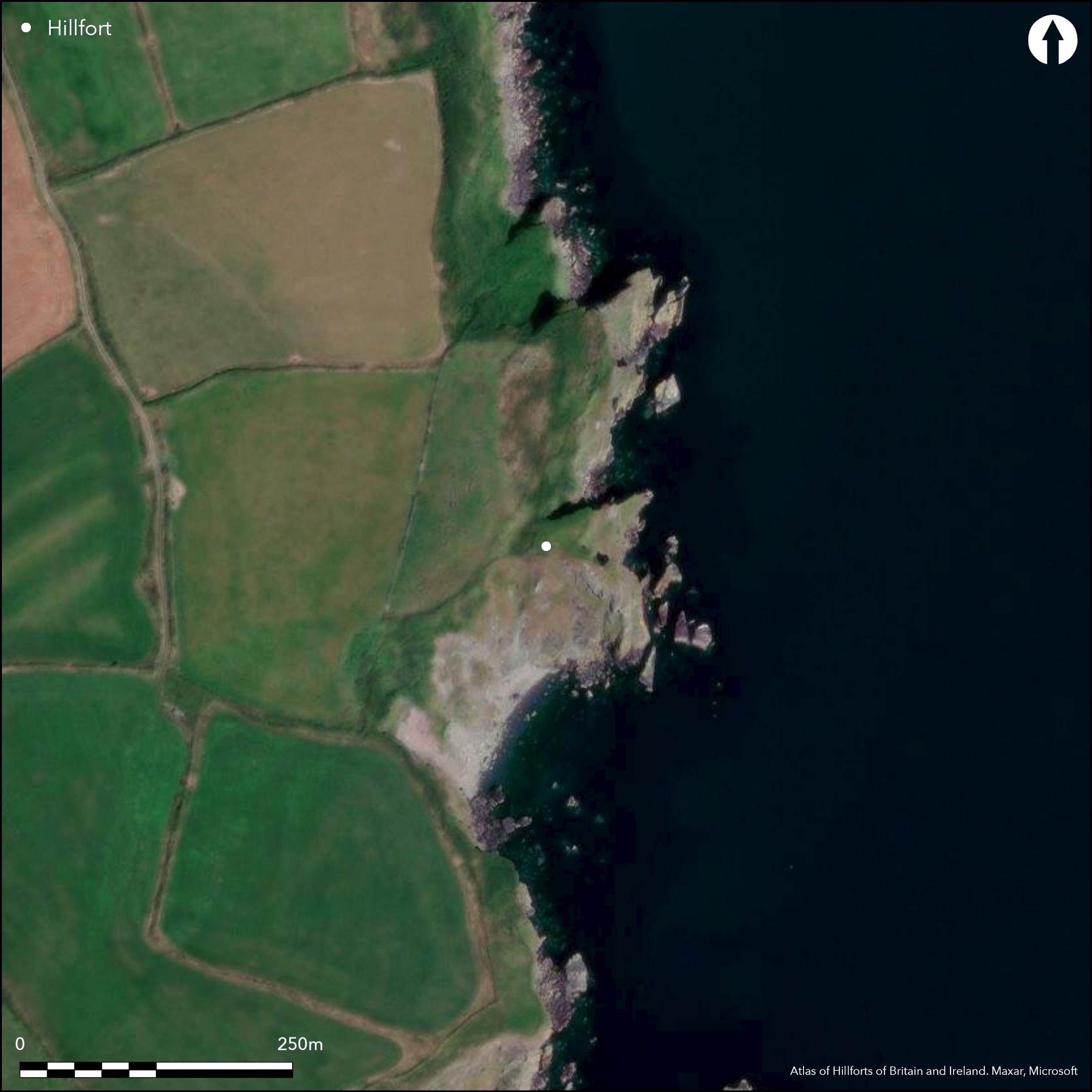
Satellite Imagery
Satellite Imagery
HER: Archaeological Survey of Ireland SMR Database WA039-013 (None)
NMR: WA 039 (None)
SM: None
NGR: None
X: 628610 Y: 582851 (IRENET95)
The site is located at ÇCarrig Philip' c.5km S of Ringville town and c.10km S of Dungarvan town, Co. Waterford. It can be described as a small sub-rectangular area barely projecting E from the mainland at an altitude of 28m OD. Marked as an 'entrenchment' on the second edition OS six-inch map. The promontory is defended on the W by a grass-grown earthen bank, measuring 4m in width and 1m in height, which surmounts a rock outcrop. It is associated with an external flat-bottomed ditch, at this point measuring 12m in width at the top and 2m at the base, with a depth of 2.8m (Moore 1999). There is a causeway (Wth 6-9m; L 9m) N of the rock outcrop and beyond the causeway the ditch is 8m in width and 2m deep. The ditch is some 30m in overall length. The interior is rectangular in plan (dims. 22m N-S; 20m E-W) and there are no recorded internal features. It is currently under pasture but is partially overgrown in areas.
Citizen Science: ✗
Reliability of Data: Confirmed
Reliability of Interpretation: Confirmed
X: -844177 Y: 6799575 (EPSG: 3857)
Longitude: -7.583370749222015 Latitude: 51.99695541775903 (EPSG:4326)
Country: Republic of Ireland
Current County or Unitary Authority: Waterford
Historic County: Waterford
Current Parish/Community/Council/Townland: Ballynamona Lower
None
| Extant | ✓ |
| Cropmark | ✗ |
| Likely Destroyed | ✗ |
None
| Woodland | ✗ |
| Commercial Forestry Plantation | ✗ |
| Parkland | ✗ |
| Pasture (Grazing) | ✓ |
| Arable | ✗ |
| Scrub/Bracken | ✗ |
| Bare Outcrop | ✗ |
| Heather/Moorland | ✗ |
| Heath | ✗ |
| Built-up | ✗ |
| Coastal Grassland | ✗ |
| Other | ✗ |
Small sub-rectangular headland barely projecting E from the mainland at an altitude of 28m OD. The promontory is defended at the W by a section of rock outcrop on top of which is a grass-covered earthen bank with an external flat-bottomed ditch
| Contour Fort | ✗ |
| Partial Contour Fort | ✗ |
| Promontory Fort | ✓ |
| Hillslope Fort | ✗ |
| Level Terrain Fort | ✗ |
| Marsh Fort | ✗ |
| Multiple Enclosure Fort | ✗ |
| Hilltop | ✗ |
| Coastal Promontory | ✓ |
| Inland Promontory | ✗ |
| Valley Bottom | ✗ |
| Knoll/Hillock/Outcrop | ✗ |
| Ridge | ✗ |
| Cliff/Plateau-edge/Scarp | ✗ |
| Hillslope | ✗ |
| Lowland | ✗ |
| Spur | ✗ |
Dominant Topographic Feature: E-facing promontory
| North | ✗ |
| Northeast | ✗ |
| East | ✓ |
| Southeast | ✗ |
| South | ✗ |
| Southwest | ✗ |
| West | ✗ |
| Northwest | ✗ |
| Level | ✗ |
Altitude: 28.0m
N/A
None
Reliability: D - None
| Pre 1200BC | ✗ |
| 1200BC - 800BC | ✗ |
| 800BC - 400BC | ✗ |
| 400BC - AD50 | ✗ |
| AD50 - AD400 | ✗ |
| AD400 - AD 800 | ✗ |
| Post AD800 | ✗ |
| Unknown | ✓ |
| Pre Hillfort: | None |
| Post Hillfort: | None |
Marked as an 'entrenchment' on the second edition OS six-inch map. Site visited and surveyed by Westropp in 1914 who describes defences. Later visited and inspected for the compilation of the Archaeological Inventory of County Waterford (Moore 1999).
| 1st Identified Map Depiction (1900): | 6-inch OS Mapping |
| 1st Identified Written Reference (1914): | Westropp |
| Earthwork Survey (1990): | Moore |
There are no recorded internal features
None
| None | ✓ |
| Spring | ✗ |
| Stream | ✗ |
| Pool | ✗ |
| Flush | ✗ |
| Well | ✗ |
| Other | ✗ |
None
| No Known Features | ✓ |
| Round Stone Structures | ✗ |
| Rectangular Stone Structures | ✗ |
| Curvilinear Platforms | ✗ |
| Other Roundhouse Evidence | ✗ |
| Pits | ✗ |
| Quarry Hollows | ✗ |
| Other | ✗ |
None
| No Known Excavation | ✓ |
| Pits | ✗ |
| Postholes | ✗ |
| Roundhouses | ✗ |
| Rectangular Structures | ✗ |
| Roads/Tracks | ✗ |
| Quarry Hollows | ✗ |
| Other | ✗ |
| Nothing Found | ✗ |
None
| No Known Geophysics | ✓ |
| Pits | ✗ |
| Roundhouses | ✗ |
| Rectangular Structures | ✗ |
| Roads/Tracks | ✗ |
| Quarry Hollows | ✗ |
| Other | ✗ |
| Nothing Found | ✗ |
None
| No Known Finds | ✓ |
| Pottery | ✗ |
| Metal | ✗ |
| Metalworking | ✗ |
| Human Bones | ✗ |
| Animal Bones | ✗ |
| Lithics | ✗ |
| Environmental | ✗ |
| Other | ✗ |
NO APPARENT FEATURES
| APs Not Checked | ✗ |
| None | ✓ |
| Roundhouses | ✗ |
| Rectangular Structures | ✗ |
| Pits | ✗ |
| Postholes | ✗ |
| Roads/Tracks | ✗ |
| Other | ✗ |
There is a causeway (Wth 6-9m; L 9m) N of the rock outcrop and a rock-cut ditch
| 1: | None |
| 2: | None |
Guard Chambers: ✗
Chevaux de Frise: ✗
| 1. Simple Gap (North west): | Causeway |
Defended at W by a section of rock outcrop on top of which is a grass-covered earthen bank (Wth 4m; H 1m) with an external flat-bottomed ditch (Wth of top 12m; Wth of base 2m; D below rock outcrop 2.8m; ext. D 1.8m).
| Area 1: | 0.07ha. |
| Total: | 0.07ha. |
Total Footprint Area: 0.09ha.
None
| ✗ | None |
| ✗ | None |
| NE Quadrant: | 0 |
| SE Quadrant: | 0 |
| SW Quadrant: | 0 |
| NW Quadrant: | 1 |
| Total: | 1 |
| Partial Univallate | ✓ |
| Univallate | ✗ |
| Partial Bivallate | ✗ |
| Bivallate | ✗ |
| Partial Multivallate | ✗ |
| Multivallate | ✗ |
| Unknown | ✗ |
| Partial Univallate | ✗ |
| Univallate | ✗ |
| Partial Bivallate | ✗ |
| Bivallate | ✗ |
| Partial Multivallate | ✗ |
| Multivallate | ✗ |
None
| None | ✗ |
| Earthen Bank | ✓ |
| Stone Wall | ✗ |
| Rubble | ✗ |
| Wall-walk | ✗ |
| Evidence of Timber | ✗ |
| Vitrification | ✗ |
| Other Burning | ✗ |
| Palisade | ✗ |
| Counter Scarp Bank | ✗ |
| Berm | ✗ |
| Unfinished | ✗ |
| Other | ✗ |
None
| None | ✗ |
| Earthen Bank | ✗ |
| Stone Wall | ✗ |
| Murus Duplex | ✗ |
| Timber-framed | ✗ |
| Timber-laced | ✗ |
| Vitrification | ✗ |
| Other Burning | ✗ |
| Palisade | ✗ |
| Counter Scarp Bank | ✗ |
| Berm | ✗ |
| Unfinished | ✗ |
| No Known Excavation | ✓ |
| Other | ✗ |
| ✗ | None |
| ✓ | None |
Number of Ditches: 1
| ✗ | None |
Moore, M. 1999. Archaeological inventory of County Waterford, 64-8. The stationary Office, Dublin
Westropp, T.J. 1914-16. Fortified headlands and castles on the south coast of Munster: Part II, from Armore to Dunmore, Co. Waterford. Proceedings of the Royal Irish Academy 32, 188-227.
Atlas of Hillforts:
Wikidata:
This work is licensed under CC BY-SA 4.0

 and should be cited as:
Lock, Gary and Ralston, Ian. 2024. Atlas of Hillforts of Britain and Ireland. Available at: https://hillforts.arch.ox.ac.uk
Document Version 1.1