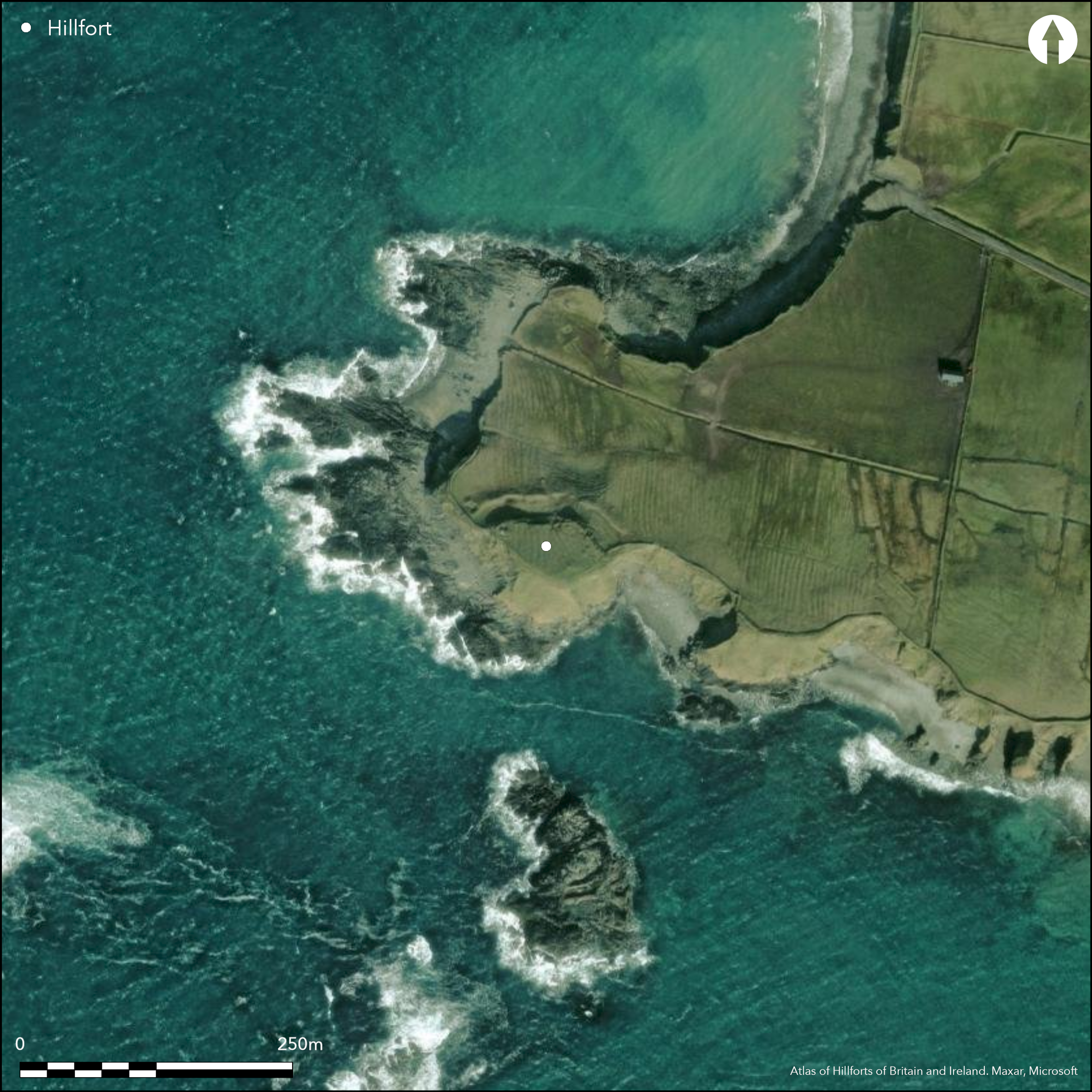
Satellite Imagery
Satellite Imagery
HER: Archaeological Survey of Ireland SMR Database GA009-012 (None)
NMR: GA 009 (None)
SM: None
NGR: None
X: 464335 Y: 763419 (IRENET95)
This promontory fort, known locally as ÇCathair na D–in' (fort of the city), is situated on a prominent headland to the S of Renvyle Point, c. 5km W of Tully, Co. Galway. It is oval on plan (90m by 50m), on ground that slopes steeply to the N from the cliff edge on the S, which is at an altitude of 6m OD. The interior is bounded round the N half by a revetted scarp, c. 9m in height, a ditch (Wth 6-10m) and an outer bank (Wth. c. 3m; H 0.85m). Lynam describes the high inner scarp as Çbuilt of large, well laid stones, unmortered—rising 14 to 17 feet above the bottom of the ditch' (1922, 166). The outer bank is described by Lynam as consisting of Çearth mixed with loose stones, as is shown in the section made by the cliff' (ibid., 166). A gap in the bank on the N and a slight rise mid-way along the ditch may mark the location of an entrance causeway into the site. This entrance opens outwards upon a steep, grassy hillside, which runs down to the N shore. In the SE part of the interior, close to the cliff edge, two grassy banks (E-W c. 5m) may represent the remains of a possible hut-site (Gosling 1993, 29). The remains of a WWII lookout stand is recorded at the W end. The site is currently under pasture with remains of later ridge and furrow clearly evident.
Citizen Science: ✗
Reliability of Data: Confirmed
Reliability of Interpretation: Confirmed
X: -1118747 Y: 7095331 (EPSG: 3857)
Longitude: -10.049878288408408 Latitude: 53.60303343305821 (EPSG:4326)
Country: Republic of Ireland
Current County or Unitary Authority: Galway
Historic County: Galway
Current Parish/Community/Council/Townland: Curragh
None
| Extant | ✓ |
| Cropmark | ✗ |
| Likely Destroyed | ✗ |
None
| Woodland | ✗ |
| Commercial Forestry Plantation | ✗ |
| Parkland | ✗ |
| Pasture (Grazing) | ✓ |
| Arable | ✗ |
| Scrub/Bracken | ✗ |
| Bare Outcrop | ✗ |
| Heather/Moorland | ✗ |
| Heath | ✗ |
| Built-up | ✗ |
| Coastal Grassland | ✗ |
| Other | ✗ |
This coastal promontory is situated on a prominent headland to the S of Renvyle Point. It can be described as an oval enclosure (Int 55m by 25m) that slopes steeply to the N from the cliff edge at an elevation of 6m OD. Defined by a revetted scarp, a ditch and an outer bank.
| Contour Fort | ✗ |
| Partial Contour Fort | ✗ |
| Promontory Fort | ✓ |
| Hillslope Fort | ✗ |
| Level Terrain Fort | ✗ |
| Marsh Fort | ✗ |
| Multiple Enclosure Fort | ✗ |
| Hilltop | ✗ |
| Coastal Promontory | ✓ |
| Inland Promontory | ✗ |
| Valley Bottom | ✗ |
| Knoll/Hillock/Outcrop | ✗ |
| Ridge | ✗ |
| Cliff/Plateau-edge/Scarp | ✗ |
| Hillslope | ✗ |
| Lowland | ✗ |
| Spur | ✗ |
Dominant Topographic Feature: S-facing promontory.
| North | ✗ |
| Northeast | ✗ |
| East | ✗ |
| Southeast | ✗ |
| South | ✓ |
| Southwest | ✗ |
| West | ✗ |
| Northwest | ✗ |
| Level | ✗ |
Altitude: 6.0m
N/A
There is no dating available for the site
Reliability: D - None
| Pre 1200BC | ✗ |
| 1200BC - 800BC | ✗ |
| 800BC - 400BC | ✗ |
| 400BC - AD50 | ✗ |
| AD50 - AD400 | ✗ |
| AD400 - AD 800 | ✗ |
| Post AD800 | ✗ |
| Unknown | ✓ |
| Pre Hillfort: | None |
| Post Hillfort: | Ridge and furrow. The remains of a WWII lookout stand is recorded at the W end. |
Depicted on the first edition OS-six-inch map as 'Caherdoona', a hachured series of arching defences that seperate the site from the mainland. Defenes described by Lynam in 1922 as consisting of earth and stone. Site surveyed in 1983 for the compilation of the Galway Archaeological Inventory (Gosling 1993, 29).
| 1st Identified Map Depiction (1840): | OS six-inch mapping |
| 1st Identified Written Reference (1922): | Lynam |
| Earthwork Survey (1983): | Gosling |
In SE part of the interior, close to the cliff edge, two grassy banks (E-W c. 5m) may represent the remains of a possible hut-site (Gosling 1993, 29).
None
| None | ✓ |
| Spring | ✗ |
| Stream | ✗ |
| Pool | ✗ |
| Flush | ✗ |
| Well | ✗ |
| Other | ✗ |
Two grassy banks are possible hut site
| No Known Features | ✗ |
| Round Stone Structures | ✗ |
| Rectangular Stone Structures | ✗ |
| Curvilinear Platforms | ✗ |
| Other Roundhouse Evidence | ✗ |
| Pits | ✗ |
| Quarry Hollows | ✗ |
| Other | ✓ |
None
| No Known Excavation | ✓ |
| Pits | ✗ |
| Postholes | ✗ |
| Roundhouses | ✗ |
| Rectangular Structures | ✗ |
| Roads/Tracks | ✗ |
| Quarry Hollows | ✗ |
| Other | ✗ |
| Nothing Found | ✗ |
None
| No Known Geophysics | ✓ |
| Pits | ✗ |
| Roundhouses | ✗ |
| Rectangular Structures | ✗ |
| Roads/Tracks | ✗ |
| Quarry Hollows | ✗ |
| Other | ✗ |
| Nothing Found | ✗ |
None
| No Known Finds | ✓ |
| Pottery | ✗ |
| Metal | ✗ |
| Metalworking | ✗ |
| Human Bones | ✗ |
| Animal Bones | ✗ |
| Lithics | ✗ |
| Environmental | ✗ |
| Other | ✗ |
NO APPARENT FEATURES
| APs Not Checked | ✓ |
| None | ✗ |
| Roundhouses | ✗ |
| Rectangular Structures | ✗ |
| Pits | ✗ |
| Postholes | ✗ |
| Roads/Tracks | ✗ |
| Other | ✗ |
A gap in the bank and a slight rise midway along the ditch may mark the location of an entrance causeway into the site. Without excavation, it cannot be confirmed if this was an original entrance.
| 1: | None |
| 2: | None |
Guard Chambers: ✗
Chevaux de Frise: ✗
| 1. Out-turned (North): | A gap in the bank and a slight rise mid-way along the ditch may mark the location of an entrance causeway into the site. This entrance opens outwards upon a steep, grassy hillside, which runs down to the N shore. |
Defined by a revetted scarp, c. 9m in hight, a ditch (Wth 6-10m) and an outer bank (Wth. C. 3m; H 0.85m). Lynam describes the high inner scarp as «built of large, well laid stones, unmorteredórising 14 to 17 feet above the bottom of the ditch (1922, 166). The outer bank is described by Lynam as consisting of «earth mixed with loose stones, as is shown in the section made by the cliff (ibid., 166).
| Area 1: | 0.11ha. |
| Total: | 0.11ha. |
Total Footprint Area: 0.27ha.
None
| ✗ | None |
| ✗ | None |
| NE Quadrant: | 2 |
| SE Quadrant: | None |
| SW Quadrant: | None |
| NW Quadrant: | 2 |
| Total: | 2 |
| Partial Univallate | ✗ |
| Univallate | ✗ |
| Partial Bivallate | ✓ |
| Bivallate | ✗ |
| Partial Multivallate | ✗ |
| Multivallate | ✗ |
| Unknown | ✗ |
| Partial Univallate | ✗ |
| Univallate | ✗ |
| Partial Bivallate | ✗ |
| Bivallate | ✗ |
| Partial Multivallate | ✗ |
| Multivallate | ✗ |
Revetted inner scarp built of large, well laid stones. Outer bank composed of earth and loose stones (shown in section made from cliff erosion).
| None | ✗ |
| Earthen Bank | ✓ |
| Stone Wall | ✓ |
| Rubble | ✗ |
| Wall-walk | ✗ |
| Evidence of Timber | ✗ |
| Vitrification | ✗ |
| Other Burning | ✗ |
| Palisade | ✗ |
| Counter Scarp Bank | ✗ |
| Berm | ✗ |
| Unfinished | ✗ |
| Other | ✗ |
None
| None | ✗ |
| Earthen Bank | ✗ |
| Stone Wall | ✗ |
| Murus Duplex | ✗ |
| Timber-framed | ✗ |
| Timber-laced | ✗ |
| Vitrification | ✗ |
| Other Burning | ✗ |
| Palisade | ✗ |
| Counter Scarp Bank | ✗ |
| Berm | ✗ |
| Unfinished | ✗ |
| No Known Excavation | ✓ |
| Other | ✗ |
| ✗ | None |
| ✓ | None |
Number of Ditches: 1
| ✗ | None |
Gosling, P. 1993. The Archaeological Inventory of County Galway: Vol 1, 28-31.Stationary Office, Dublin.
Lynam, E. W. 1922. Prehistoric monuments at Rinvyle, Co. Galway. Royal Society of Antiquaries of Ireland 12, 166.
Atlas of Hillforts:
Wikidata:
This work is licensed under CC BY-SA 4.0

 and should be cited as:
Lock, Gary and Ralston, Ian. 2024. Atlas of Hillforts of Britain and Ireland. Available at: https://hillforts.arch.ox.ac.uk
Document Version 1.1