Satellite Imagery
Satellite Imagery
HER: Archaeological Survey of Ireland SMR Database GA119-001 (None)
NMR: GA 119 (None)
SM: None
NGR: None
X: 486989 Y: 707319 (IRENET95)
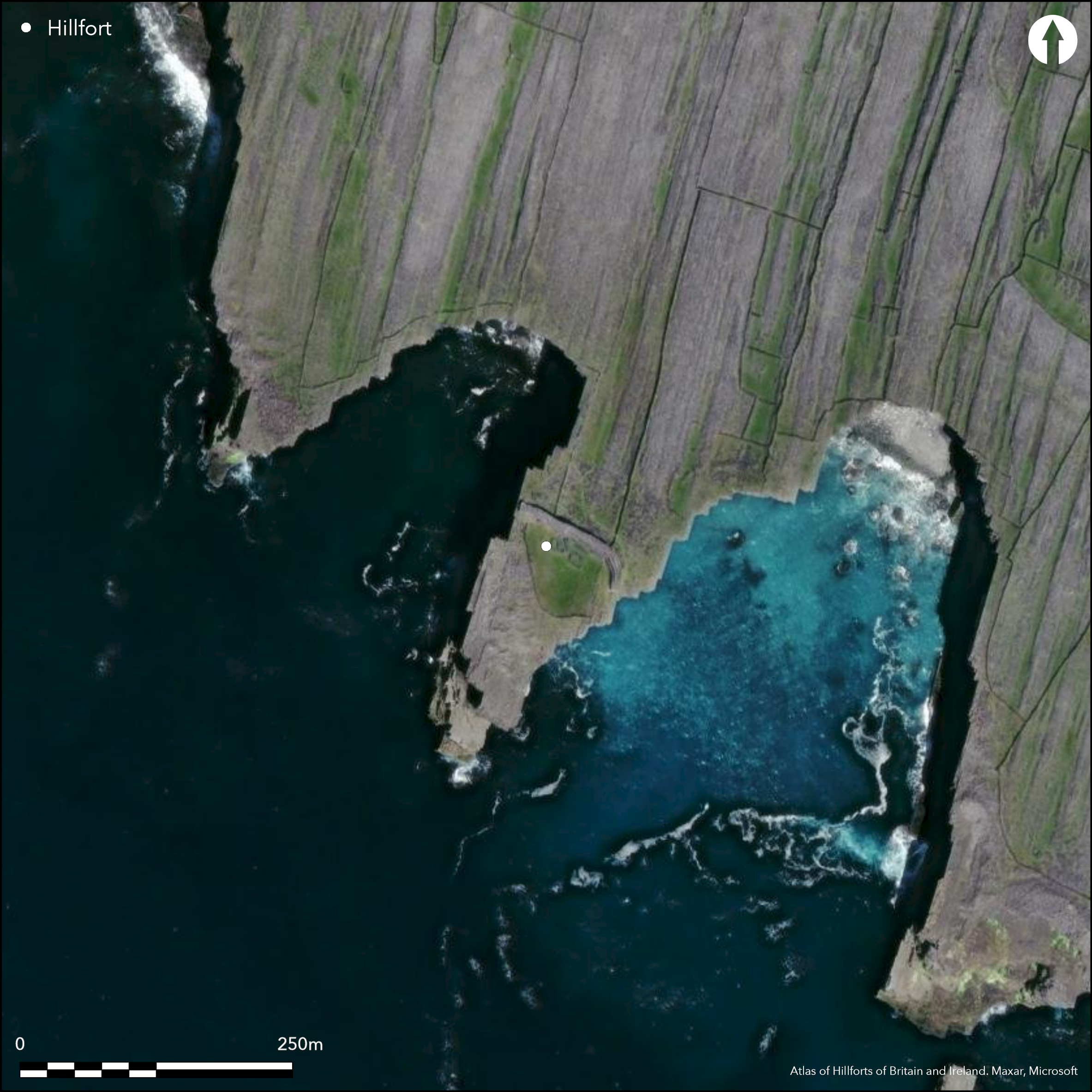
This headland is situated on a sheer cliff top on the SW side of Inis M†r at an altitude of 6m OD. The promontory, known locally as ÇD–n D–cathair', is recorded on early OS six-inch maps as ÇDooncaher' (the black fort) (Westropp 1914, 333). It can be described as an irregular area of limestone pavement (110m NE-SW by 80 NW-SE) enclosed on the landward side (NE) by a massive drystone rampart drawn in an arc from NW to SE for c. 73m. It measures 7.2m in maximum width by 3.7m in height. The inner face of the rampart is composed of three terraces connected by steps. The outer face of the wall is buttressed. These features are the result of nineteenth century restoration (Gosling 1993, 29). Westropp notes that before the restoration by the Board of Works..'the wall had two sections, two flights of steps, traces of a terrace, and a chamber in its thickness; a defaced entrance remained to the east near the cliff' (1914, 334). There are traces of an entrance to the E, measuring c. 2.2m, however, Westropp, citing Petrie in 1821, states that it Çhad a perfect entrance to the west, destroyed—by a great cliff-fall before 1839' (ibid.). The huts are located immediately inside the stone ramparts described by Westropp as Ç a group of four, perhaps five, conjoined huts and a small cell in the wall'. He also describes a row of oblong conical huts along the W ridge within the interior which were entirely swept away by the sea since 1839. Outside the rampart is a dense band of chevaux-de-fris (Wth 55m) of low square-topped slabs, within which are two groups of houses Çwith middens, outside the wall'. Westropp suggests these are later in date.
Citizen Science: ✗
Reliability of Data: Confirmed
Reliability of Interpretation: Confirmed
X: -1078433 Y: 7002344 (EPSG: 3857)
Longitude: -9.687730853914069 Latitude: 53.1044619190704 (EPSG:4326)
Country: Republic of Ireland
Current County or Unitary Authority: Galway (Inis Mór)
Historic County: Galway
Current Parish/Community/Council/Townland: Killeany
Defences substantially re-built in the 19th century
| Extant | ✓ |
| Cropmark | ✗ |
| Likely Destroyed | ✗ |
Promontory situated on an irregular area of limestone pavement.
| Woodland | ✗ |
| Commercial Forestry Plantation | ✗ |
| Parkland | ✗ |
| Pasture (Grazing) | ✗ |
| Arable | ✗ |
| Scrub/Bracken | ✗ |
| Bare Outcrop | ✗ |
| Heather/Moorland | ✗ |
| Heath | ✗ |
| Built-up | ✗ |
| Coastal Grassland | ✗ |
| Other | ✗ |
This coastal promontory fort is situated on a sheer cliff top on the SW side of Inis M† at an altitude of 6m OD. It encloses an irregular area of limestone pavement a massive drystone rampart drawn in an arc to bar access from the NE and measuring c. 73m in length.
| Contour Fort | ✗ |
| Partial Contour Fort | ✗ |
| Promontory Fort | ✓ |
| Hillslope Fort | ✗ |
| Level Terrain Fort | ✗ |
| Marsh Fort | ✗ |
| Multiple Enclosure Fort | ✗ |
| Hilltop | ✗ |
| Coastal Promontory | ✓ |
| Inland Promontory | ✗ |
| Valley Bottom | ✗ |
| Knoll/Hillock/Outcrop | ✗ |
| Ridge | ✗ |
| Cliff/Plateau-edge/Scarp | ✗ |
| Hillslope | ✗ |
| Lowland | ✗ |
| Spur | ✗ |
Dominant Topographic Feature: SW-facing promontory
| North | ✗ |
| Northeast | ✗ |
| East | ✗ |
| Southeast | ✗ |
| South | ✗ |
| Southwest | ✓ |
| West | ✗ |
| Northwest | ✗ |
| Level | ✗ |
Altitude: 6.0m
N/A
There is no dating available for the site
Reliability: D - None
| Pre 1200BC | ✗ |
| 1200BC - 800BC | ✗ |
| 800BC - 400BC | ✗ |
| 400BC - AD50 | ✗ |
| AD50 - AD400 | ✗ |
| AD400 - AD 800 | ✗ |
| Post AD800 | ✗ |
| Unknown | ✓ |
| Pre Hillfort: | None |
| Post Hillfort: | None |
ÇD–n D–cathair' is recorded on the first edition of the OS 6-inch map (1840). Described by Petrie in 1821, the site was extensively surveyed by Westropp in 1914.
| 1st Identified Written Reference (1821): | George Petrie |
| 1st Identified Map Depiction (1840): | First edition OS six-inch map |
| Earthwork Survey (1914): | Westropp |
| Other (1927): | Flanagan 1927, Vol. 3, 242-50 |
| Earthwork Survey (1984): | Gosling |
| Other (1986): | Robinson 1986, 37-40 |
Hut sites are located immediately inside the stone ramparts. They are described by Westropp as Ç a group of four, perhaps five, conjoined huts and a small cell in the wall. He also describes a row of oblong conical huts along the W ridge within the interior which were entirely swept away by the sea since 1839.
None
| None | ✓ |
| Spring | ✗ |
| Stream | ✗ |
| Pool | ✗ |
| Flush | ✗ |
| Well | ✗ |
| Other | ✗ |
None
| No Known Features | ✗ |
| Round Stone Structures | ✓ |
| Rectangular Stone Structures | ✗ |
| Curvilinear Platforms | ✗ |
| Other Roundhouse Evidence | ✗ |
| Pits | ✗ |
| Quarry Hollows | ✗ |
| Other | ✗ |
None
| No Known Excavation | ✓ |
| Pits | ✗ |
| Postholes | ✗ |
| Roundhouses | ✗ |
| Rectangular Structures | ✗ |
| Roads/Tracks | ✗ |
| Quarry Hollows | ✗ |
| Other | ✗ |
| Nothing Found | ✗ |
None
| No Known Geophysics | ✓ |
| Pits | ✗ |
| Roundhouses | ✗ |
| Rectangular Structures | ✗ |
| Roads/Tracks | ✗ |
| Quarry Hollows | ✗ |
| Other | ✗ |
| Nothing Found | ✗ |
None
| No Known Finds | ✓ |
| Pottery | ✗ |
| Metal | ✗ |
| Metalworking | ✗ |
| Human Bones | ✗ |
| Animal Bones | ✗ |
| Lithics | ✗ |
| Environmental | ✗ |
| Other | ✗ |
None
| APs Not Checked | ✗ |
| None | ✗ |
| Roundhouses | ✓ |
| Rectangular Structures | ✗ |
| Pits | ✗ |
| Postholes | ✗ |
| Roads/Tracks | ✗ |
| Other | ✗ |
There are traces of an entrance to the E through the stone rampart, measuring c. 2.2m, however, Westropp, citing Petrie in 1821, states that it Çhad a perfect entrance to the west, destroyed—by a great cliff-fall before 1839 (1914, 334)
| 1: | Gap in defences to the E. This is not the original entrance |
| 2: | Original entrance to the W destoyed by coastal erosion |
Guard Chambers: ✗
Chevaux de Frise: ✓
Outside the rampart is a dense band of chevaux-de-frise (Wth 55m) of low square-topped slabs.
| 1. Uncertain (West): | This entrance was destroyed by coastal erosion |
Enclosed on the landward side (NE) by a massive drystone rampart drawn in an arc for c. 73m. It measures 7.2m in maximum width by 3.7m in height. The inner face of the rampart is composed of three terraces connected by steps. The outer face of the wall is buttressed. Much of what remains was extensively restored in the 19th century.
| Area 1: | 0.6ha. |
| Total: | 0.6ha. |
Total Footprint Area: 1.0ha.
None
| ✗ | None |
| ✗ | None |
| NE Quadrant: | 1 |
| SE Quadrant: | 0 |
| SW Quadrant: | 0 |
| NW Quadrant: | 0 |
| Total: | 1 |
| Partial Univallate | ✓ |
| Univallate | ✗ |
| Partial Bivallate | ✗ |
| Bivallate | ✗ |
| Partial Multivallate | ✗ |
| Multivallate | ✗ |
| Unknown | ✗ |
| Partial Univallate | ✗ |
| Univallate | ✗ |
| Partial Bivallate | ✗ |
| Bivallate | ✗ |
| Partial Multivallate | ✗ |
| Multivallate | ✗ |
Inner face built in a series of terraces, and though there is no evidence that the upper was a wall walk, this box has been ticked here
| None | ✗ |
| Earthen Bank | ✗ |
| Stone Wall | ✓ |
| Rubble | ✗ |
| Wall-walk | ✓ |
| Evidence of Timber | ✗ |
| Vitrification | ✗ |
| Other Burning | ✗ |
| Palisade | ✗ |
| Counter Scarp Bank | ✗ |
| Berm | ✗ |
| Unfinished | ✗ |
| Other | ✗ |
None
| None | ✗ |
| Earthen Bank | ✗ |
| Stone Wall | ✗ |
| Murus Duplex | ✗ |
| Timber-framed | ✗ |
| Timber-laced | ✗ |
| Vitrification | ✗ |
| Other Burning | ✗ |
| Palisade | ✗ |
| Counter Scarp Bank | ✗ |
| Berm | ✗ |
| Unfinished | ✗ |
| No Known Excavation | ✓ |
| Other | ✗ |
| ✗ | None |
| ✗ | None |
Number of Ditches: 0
| ✗ | None |
Gosling, P. (1993). The Archaeological Inventory of County Galway: Vol 1, 28-31. Stationary Office, Dublin
Harbison, P 1971 Wooden and stone chevaux-de frise in central and western Europe. Proc Prehist Soc 37 (1971), 195-225
O'Flanagan, Rev. M. (Compiler) (1927) Letters containing information relative to the antiquities of the county of Galway collected during the progress of the Ordnance Survey in 1839. Typescript in 3 vols. Bray
Robinson, T. (1986) Stones of Aran: pilgrimage. Mullingar
Westropp, T.J. (1914) Promontory forts of the Islands of Connacht. Journal of the Royal Society of Antiquaries of Ireland 44, 333
Atlas of Hillforts:
Wikidata:
This work is licensed under CC BY-SA 4.0

 and should be cited as:
Lock, Gary and Ralston, Ian. 2024. Atlas of Hillforts of Britain and Ireland. Available at: https://hillforts.arch.ox.ac.uk
Document Version 1.1