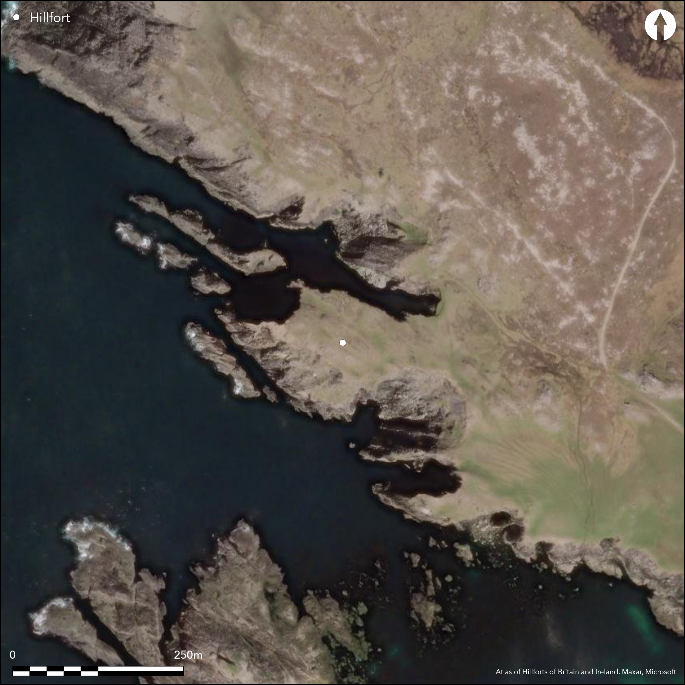
Satellite Imagery
Satellite Imagery
HER: Archaeological Survey of Ireland SMR Database GA009D024 (None)
NMR: GA 009 (None)
SM: None
NGR: None
X: 450708 Y: 765666 (IRENET95)
This promontory fort is situated on a steep headland, flanked by sheer cliffs, at the SW end of Inishbofin off the W coast of Co. Galway. The site, known locally as ÇD–n M†r', is roughly rectangular (110m by 60m), rising towards the W and defended on the landward side (ESE) by a curving drystone wall measuring 3-4m in thickness with a height of 0.95m. The wall peters out towards the N and it is evident that much of it has collapsed since surveyed by Westropp in the early twentieth century. He observed that Çit is of the best type of stonework, with two faces of large blocks, 2 and 3 feet long, and nearly as deep and high' (1914, 332). He describes it as being well built, 10-13 feet thick and from 3 to 5 feet high. Some 9.75m from the S end of the wall was a well-defined gate (Wth 1.9m), of which no trace now survives. Westropp notes that it Çlooks eastwards, and has parallel sides 6 feet 3 inches apart' (1914, 332). Outside and downslope from the wall is a natural hollow Çapparently untouched by human labour' running half-way across the neck of the promontory. Apart from Çan oblong patch of stones', 20m inside the wall, the interior is featureless (Gosling 1993, 31), Çalthough several hut-sites (some with several cells) are found round the low hill eastward from the D–n' (Westropp 1914, 332).
Citizen Science: ✗
Reliability of Data: Confirmed
Reliability of Interpretation: Confirmed
X: -1141769 Y: 7098422 (EPSG: 3857)
Longitude: -10.256688937971605 Latitude: 53.6195078967428 (EPSG:4326)
Country: Republic of Ireland
Current County or Unitary Authority: Galway (Inishbofin)
Historic County: Galway
Current Parish/Community/Council/Townland: Westquarter
None
| Extant | ✓ |
| Cropmark | ✗ |
| Likely Destroyed | ✗ |
None
| Woodland | ✗ |
| Commercial Forestry Plantation | ✗ |
| Parkland | ✗ |
| Pasture (Grazing) | ✓ |
| Arable | ✗ |
| Scrub/Bracken | ✗ |
| Bare Outcrop | ✗ |
| Heather/Moorland | ✗ |
| Heath | ✗ |
| Built-up | ✗ |
| Coastal Grassland | ✗ |
| Other | ✗ |
This coastal promontory fort is situated on a steep headland, flanked by sheer cliffs. It is roughly rectangular and the ground rises towards the W. It is defended on the landward side (ESE) by a curving drystone wall.
| Contour Fort | ✗ |
| Partial Contour Fort | ✗ |
| Promontory Fort | ✓ |
| Hillslope Fort | ✗ |
| Level Terrain Fort | ✗ |
| Marsh Fort | ✗ |
| Multiple Enclosure Fort | ✗ |
| Hilltop | ✗ |
| Coastal Promontory | ✓ |
| Inland Promontory | ✗ |
| Valley Bottom | ✗ |
| Knoll/Hillock/Outcrop | ✗ |
| Ridge | ✗ |
| Cliff/Plateau-edge/Scarp | ✗ |
| Hillslope | ✗ |
| Lowland | ✗ |
| Spur | ✗ |
Dominant Topographic Feature: NW-facing promontory
| North | ✗ |
| Northeast | ✗ |
| East | ✗ |
| Southeast | ✗ |
| South | ✗ |
| Southwest | ✗ |
| West | ✗ |
| Northwest | ✓ |
| Level | ✗ |
Altitude: 18.0m
N/A
There is no dating available for the site
Reliability: D - None
| Pre 1200BC | ✗ |
| 1200BC - 800BC | ✗ |
| 800BC - 400BC | ✗ |
| 400BC - AD50 | ✗ |
| AD50 - AD400 | ✗ |
| AD400 - AD 800 | ✗ |
| Post AD800 | ✗ |
| Unknown | ✓ |
| Pre Hillfort: | None |
| Post Hillfort: | None |
The site is named 'Doonmore' on the first edition 6-inch OS map. Some indication of the defences are also marked running from the SE across the neck of the headland. The site is described by Westropp in the early twentieth century (1911;1914).
| 1st Identified Map Depiction (1840): | First edition OS 6-inch mapping |
| 1st Identified Written Reference (1911): | Westropp |
| Earthwork Survey (1914): | Westropp |
| Other (1983): | Gosling |
There are no recorded features within the interior of the site, however, several hut-sites are known outside the fort and downhill from the promontory.
None
| None | ✓ |
| Spring | ✗ |
| Stream | ✗ |
| Pool | ✗ |
| Flush | ✗ |
| Well | ✗ |
| Other | ✗ |
None
| No Known Features | ✓ |
| Round Stone Structures | ✗ |
| Rectangular Stone Structures | ✗ |
| Curvilinear Platforms | ✗ |
| Other Roundhouse Evidence | ✗ |
| Pits | ✗ |
| Quarry Hollows | ✗ |
| Other | ✗ |
None
| No Known Excavation | ✓ |
| Pits | ✗ |
| Postholes | ✗ |
| Roundhouses | ✗ |
| Rectangular Structures | ✗ |
| Roads/Tracks | ✗ |
| Quarry Hollows | ✗ |
| Other | ✗ |
| Nothing Found | ✗ |
None
| No Known Geophysics | ✓ |
| Pits | ✗ |
| Roundhouses | ✗ |
| Rectangular Structures | ✗ |
| Roads/Tracks | ✗ |
| Quarry Hollows | ✗ |
| Other | ✗ |
| Nothing Found | ✗ |
None
| No Known Finds | ✓ |
| Pottery | ✗ |
| Metal | ✗ |
| Metalworking | ✗ |
| Human Bones | ✗ |
| Animal Bones | ✗ |
| Lithics | ✗ |
| Environmental | ✗ |
| Other | ✗ |
NO APPARENT FEATURES
| APs Not Checked | ✗ |
| None | ✓ |
| Roundhouses | ✗ |
| Rectangular Structures | ✗ |
| Pits | ✗ |
| Postholes | ✗ |
| Roads/Tracks | ✗ |
| Other | ✗ |
Some 9.75m from the S end of the wall was a well-defined gate (Wth 1.9m). This no longer survives. Westropp notes that it looked eastwards, and had parallel sides '6 feet 3 inches apart (1914, 332). He also observed that the outer entrance was destroyed 'but probably had coursed piers, and was a couple of feet narrower. He describes that no 'lintels' were evident and the passage was '10 feet deep'.
| 1: | None |
| 2: | This entrance no longer survives |
Guard Chambers: ✗
Chevaux de Frise: ✗
| 1. Other Forms (South east): | Probable checks at outer end of the passage |
The site is defended on the landward side (ESE) by a curving drystone wall measuring 3-4m thick with a height of 0.95m. The wall peters out towards the N and it is evident that much of it has collapsed.Westropp notes that it is well built and composed of stonework with two faces of large blocks. Outside and downslope from the wall is a natural hollow «apparently untouched by human labour running half-way across the neck of the promontory.
| Area 1: | 0.76ha. |
| Total: | 0.76ha. |
Total Footprint Area: 0.83ha.
None
| ✗ | None |
| ✗ | None |
| NE Quadrant: | 0 |
| SE Quadrant: | 1 |
| SW Quadrant: | 0 |
| NW Quadrant: | 0 |
| Total: | 1 |
| Partial Univallate | ✓ |
| Univallate | ✗ |
| Partial Bivallate | ✗ |
| Bivallate | ✗ |
| Partial Multivallate | ✗ |
| Multivallate | ✗ |
| Unknown | ✗ |
| Partial Univallate | ✗ |
| Univallate | ✗ |
| Partial Bivallate | ✗ |
| Bivallate | ✗ |
| Partial Multivallate | ✗ |
| Multivallate | ✗ |
None
| None | ✗ |
| Earthen Bank | ✗ |
| Stone Wall | ✓ |
| Rubble | ✗ |
| Wall-walk | ✗ |
| Evidence of Timber | ✗ |
| Vitrification | ✗ |
| Other Burning | ✗ |
| Palisade | ✗ |
| Counter Scarp Bank | ✗ |
| Berm | ✗ |
| Unfinished | ✗ |
| Other | ✗ |
None
| None | ✗ |
| Earthen Bank | ✗ |
| Stone Wall | ✗ |
| Murus Duplex | ✗ |
| Timber-framed | ✗ |
| Timber-laced | ✗ |
| Vitrification | ✗ |
| Other Burning | ✗ |
| Palisade | ✗ |
| Counter Scarp Bank | ✗ |
| Berm | ✗ |
| Unfinished | ✗ |
| No Known Excavation | ✓ |
| Other | ✗ |
| ✗ | None |
| ✓ | Natural hollow outside and downslope from the rampart wall. It runs in a NE-SW direction halfway across the neck of the promontory. |
Number of Ditches: 0
| ✗ | None |
Gosling, P. 1993. The Archaeological Inventory of County Galway: Vol 1, 28-31.Stationary Office, Dublin
Westropp, T.J. 1914. Promontory forts of the Islands of Connacht. Journal of the Royal Society of Antiquaries of Ireland 44, 333
Atlas of Hillforts:
Wikidata:
This work is licensed under CC BY-SA 4.0

 and should be cited as:
Lock, Gary and Ralston, Ian. 2024. Atlas of Hillforts of Britain and Ireland. Available at: https://hillforts.arch.ox.ac.uk
Document Version 1.1