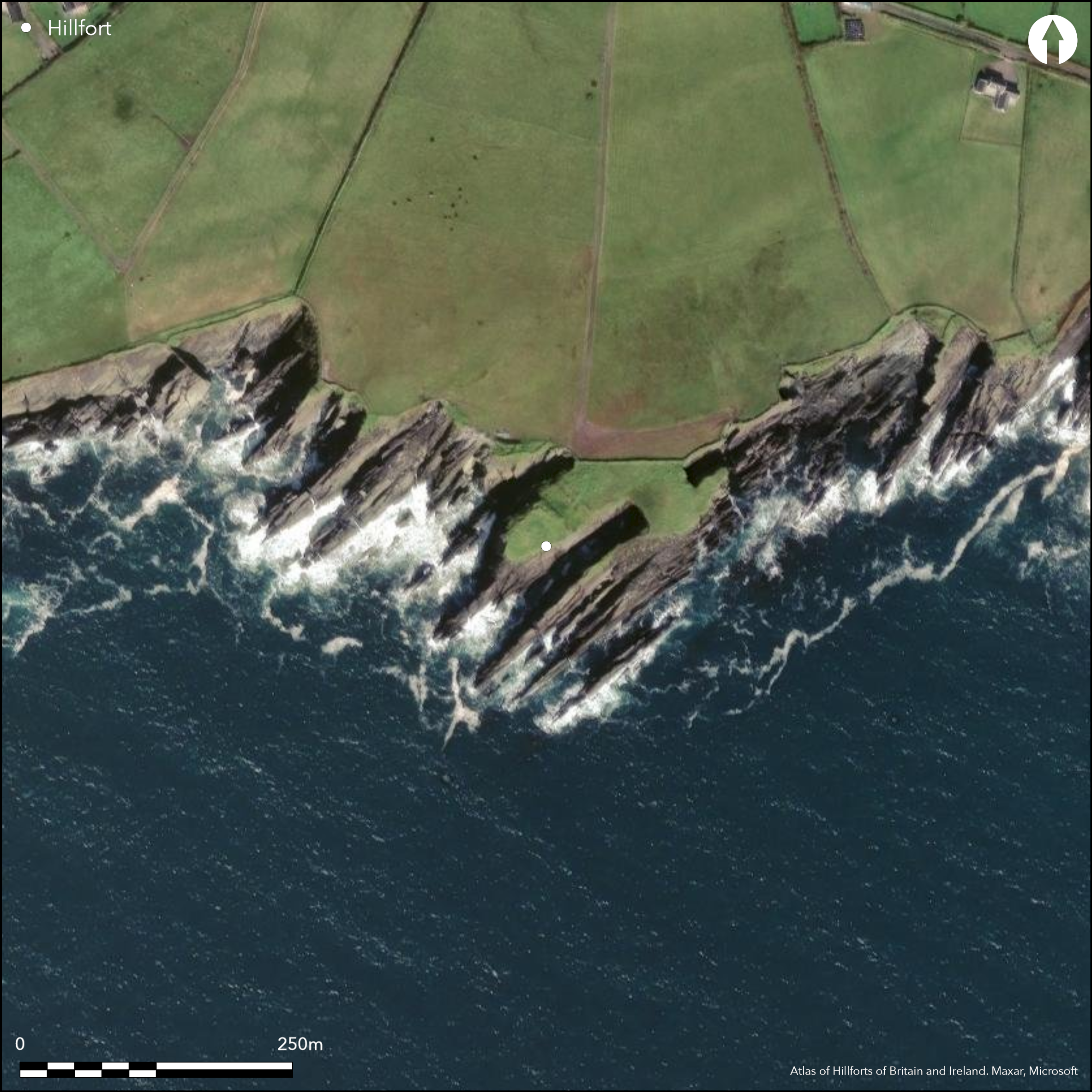
Satellite Imagery
Satellite Imagery
HER: Archaeological Survey of Ireland SMR Database KE096-005 (None)
NMR: KE 096 (None)
SM: None
NGR: None
X: 438205 Y: 568426 (IRENET95)
This headland, known locally as the ÇD–n' and referred to by Westropp as ÇDuncanuig (Westropp 1912, 312-5; Redmond 1995, 36), projects SW from the mainland into St. Finan's Bay on the Iveragh peninsula, Co. Kerry at an altitude of 7m OD. The site is depicted on the first edition of the OS 6-inch map, which along with the later 25-inch map show the defences crossing a natural arch to include the adjacent fingers of rock jutting out into the sea parallel on the SE. The arch has since fallen, and the adjacent rocks on the SE are heavily eroded, but the interior must once have been considerably larger, originally carried across the chasm on a much broad natural arch. The enclosing defences, which bar access from the NE, are now found only on the NW part of the headland, and where best preserved on the NW side of an entrance causeway comprise three ramparts with intervening ditches. On the SE side of the causeway, Westropp recorded the innermost of these ramparts, then with internal and external faces clearly visible, crossing the sea-arch to the SE (Westropp 1912, 313; O'Sullivan and Sheehan 1996, 128), but on this side there is no evidence of the middle rampart, and there is a broad depression behind the outer rampart, which here is accompanied by an external ditch. This rampart turns inwards for a distance of 8.5m to either side of the entrance causeway to form a deep passage-way in which Westropp noted a pair of Çgate-piers' and stone facing, though these are no longer visible. The causeway is c. 3m wide and 21.5m long, and in the depression between the ramparts on its SE side he also noted the remains of a possible hut-site. A depression at the NW end of the inner rampart also suggests the presence of a wall-chamber (Redmond 1995, 36). The triangular interior of the site, which now measures 34m from NE to SW by a maximum of 21m transversely, is flat and there are no other recorded features.
Citizen Science: ✗
Reliability of Data: Confirmed
Reliability of Interpretation: Confirmed
X: -1151968 Y: 6772073 (EPSG: 3857)
Longitude: -10.348304675048032 Latitude: 51.84458213275375 (EPSG:4326)
Country: Republic of Ireland
Current County or Unitary Authority: Kerry (Iveragh Peninsula)
Historic County: Kerry
Current Parish/Community/Council/Townland: Kerry
Heavy erosion along the cliffs
| Extant | ✓ |
| Cropmark | ✗ |
| Likely Destroyed | ✓ |
None
| Woodland | ✗ |
| Commercial Forestry Plantation | ✗ |
| Parkland | ✗ |
| Pasture (Grazing) | ✓ |
| Arable | ✗ |
| Scrub/Bracken | ✗ |
| Bare Outcrop | ✗ |
| Heather/Moorland | ✗ |
| Heath | ✗ |
| Built-up | ✗ |
| Coastal Grassland | ✗ |
| Other | ✗ |
This coastal promontory projects SW from the mainland into St. Finans Bay at an altitude of 7m OD. It once consisted of two headlands joined by an arch which has since fallen, isolating the two landmasses. The enclosing defences survive only on the NE headland (44m NE-SW by 19m NW-SE), consisting of two earthen banks, a ditch and a substantial stone wall.
| Contour Fort | ✗ |
| Partial Contour Fort | ✗ |
| Promontory Fort | ✓ |
| Hillslope Fort | ✗ |
| Level Terrain Fort | ✗ |
| Marsh Fort | ✗ |
| Multiple Enclosure Fort | ✗ |
| Hilltop | ✗ |
| Coastal Promontory | ✓ |
| Inland Promontory | ✗ |
| Valley Bottom | ✗ |
| Knoll/Hillock/Outcrop | ✗ |
| Ridge | ✗ |
| Cliff/Plateau-edge/Scarp | ✗ |
| Hillslope | ✗ |
| Lowland | ✗ |
| Spur | ✗ |
Dominant Topographic Feature: SW-facing promontory
| North | ✗ |
| Northeast | ✗ |
| East | ✗ |
| Southeast | ✗ |
| South | ✗ |
| Southwest | ✓ |
| West | ✗ |
| Northwest | ✗ |
| Level | ✗ |
Altitude: 7.0m
N/A
There is no dating available for the site
Reliability: D - None
| Pre 1200BC | ✗ |
| 1200BC - 800BC | ✗ |
| 800BC - 400BC | ✗ |
| 400BC - AD50 | ✗ |
| AD50 - AD400 | ✗ |
| AD400 - AD 800 | ✗ |
| Post AD800 | ✗ |
| Unknown | ✓ |
| Pre Hillfort: | None |
| Post Hillfort: | None |
The site is depicted on the first edition of the OS 6-inch map. Surveyed by Westropp in 1912 and visited for the compilation of the Iveragh Archaeological Inventory in the 1990s (O'Sullivan and Sheehan 1996, 128).
| 1st Identified Map Depiction (1840): | OS 6-inch mapping |
| 1st Identified Written Reference (1912): | Westropp |
| Earthwork Survey (1996): | O'Sullivan and Sheehan 1996 |
On the SE side fo the causeway, between the outer and innermost banks, is a large depression, where Westropp noted the remains of a possible hut-site. A depression at the NE end of the wall also suggests the presence of a wall-chamber (Redmond 1995, 36)
None
| None | ✓ |
| Spring | ✗ |
| Stream | ✗ |
| Pool | ✗ |
| Flush | ✗ |
| Well | ✗ |
| Other | ✗ |
None
| No Known Features | ✓ |
| Round Stone Structures | ✗ |
| Rectangular Stone Structures | ✗ |
| Curvilinear Platforms | ✗ |
| Other Roundhouse Evidence | ✗ |
| Pits | ✗ |
| Quarry Hollows | ✗ |
| Other | ✗ |
None
| No Known Excavation | ✓ |
| Pits | ✗ |
| Postholes | ✗ |
| Roundhouses | ✗ |
| Rectangular Structures | ✗ |
| Roads/Tracks | ✗ |
| Quarry Hollows | ✗ |
| Other | ✗ |
| Nothing Found | ✗ |
None
| No Known Geophysics | ✓ |
| Pits | ✗ |
| Roundhouses | ✗ |
| Rectangular Structures | ✗ |
| Roads/Tracks | ✗ |
| Quarry Hollows | ✗ |
| Other | ✗ |
| Nothing Found | ✗ |
None
| No Known Finds | ✓ |
| Pottery | ✗ |
| Metal | ✗ |
| Metalworking | ✗ |
| Human Bones | ✗ |
| Animal Bones | ✗ |
| Lithics | ✗ |
| Environmental | ✗ |
| Other | ✗ |
NO APPARENT FEATURES
| APs Not Checked | ✗ |
| None | ✓ |
| Roundhouses | ✗ |
| Rectangular Structures | ✗ |
| Pits | ✗ |
| Postholes | ✗ |
| Roads/Tracks | ✗ |
| Other | ✗ |
A causeway c. 3m wide and 21.5m long pierces these defences. Westropp recorded a pair of Çgate-piers and stone facing along this entrance causeway, but these are no longer visible.
| 1: | None |
| 2: | None |
Guard Chambers: ✗
Chevaux de Frise: ✗
| 1. Passage-way/Corridor (North east): | None |
The enclosing defences are only found on the NW headland, where best preserved on the NW side of the entrance causeway consisting of a substantial stone-faced inner rampart with an external ditch accompanied by two outer ramparts separated by another ditch. Westropp recorded that the inner rampart continued to the SE across the sea-arch (which has since fallen) to the narrow adjacent promontory, and though it now resembles an earthen bank some sections are exposed revealing a battered inner face; in its collapsed state it is 6m wide and 1.3m high above the interior. The middle rampart, only visible on the NW side of the entrance causeway measures 3.7m wide with a height of 0.95m. The outer rampart measures 2.9m wide with a height of 0.55m on both sides The inner ditch, which extends the full width of the promontory measures up to 10.4m wide, with a depth of 1.99m below the crest of the middle rampart.
| Area 1: | 0.23ha. |
| Total: | 0.23ha. |
Total Footprint Area: 0.42ha.
None
| ✗ | The promontory once consisted of two headlands joined by an arch which has since fallen, isolating the two landmasses, and the interior is now little more than 0.07ha |
| ✗ | None |
| NE Quadrant: | 3 |
| SE Quadrant: | 0 |
| SW Quadrant: | 0 |
| NW Quadrant: | 0 |
| Total: | 3 |
| Partial Univallate | ✗ |
| Univallate | ✗ |
| Partial Bivallate | ✗ |
| Bivallate | ✗ |
| Partial Multivallate | ✓ |
| Multivallate | ✗ |
| Unknown | ✗ |
| Partial Univallate | ✗ |
| Univallate | ✗ |
| Partial Bivallate | ✗ |
| Bivallate | ✗ |
| Partial Multivallate | ✗ |
| Multivallate | ✗ |
None
| None | ✗ |
| Earthen Bank | ✓ |
| Stone Wall | ✓ |
| Rubble | ✗ |
| Wall-walk | ✗ |
| Evidence of Timber | ✗ |
| Vitrification | ✗ |
| Other Burning | ✗ |
| Palisade | ✗ |
| Counter Scarp Bank | ✗ |
| Berm | ✗ |
| Unfinished | ✗ |
| Other | ✗ |
None
| None | ✗ |
| Earthen Bank | ✗ |
| Stone Wall | ✗ |
| Murus Duplex | ✗ |
| Timber-framed | ✗ |
| Timber-laced | ✗ |
| Vitrification | ✗ |
| Other Burning | ✗ |
| Palisade | ✗ |
| Counter Scarp Bank | ✗ |
| Berm | ✗ |
| Unfinished | ✗ |
| No Known Excavation | ✓ |
| Other | ✗ |
| ✗ | None |
| ✓ | None |
Number of Ditches: 2
| ✗ | None |
O'Sullivan, A and Sheehan, J. 1996. Iveragh Peninsula: An Archaeological Survey of South Kerry. Cork University Press. Cork
Redmond, M. 1995. A survey of the promontory forts of the Kerry peninsulas. Journal of the Kerry Archaeological and Historical Society 28, 5-63.
Westropp, T.J. 1912. Notes on the promontory forts and similar structures of County Kerry. Journal of the Royal Society of Antiquaries of Ireland 42, 285-324.
Atlas of Hillforts:
Wikidata:
This work is licensed under CC BY-SA 4.0

 and should be cited as:
Lock, Gary and Ralston, Ian. 2024. Atlas of Hillforts of Britain and Ireland. Available at: https://hillforts.arch.ox.ac.uk
Document Version 1.1