Satellite Imagery
Satellite Imagery
HER: Archaeological Survey of Ireland SMR Database KE069-010 (None)
NMR: KE 069 (None)
SM: None
NGR: None
X: 443995 Y: 581823 (IRENET95)
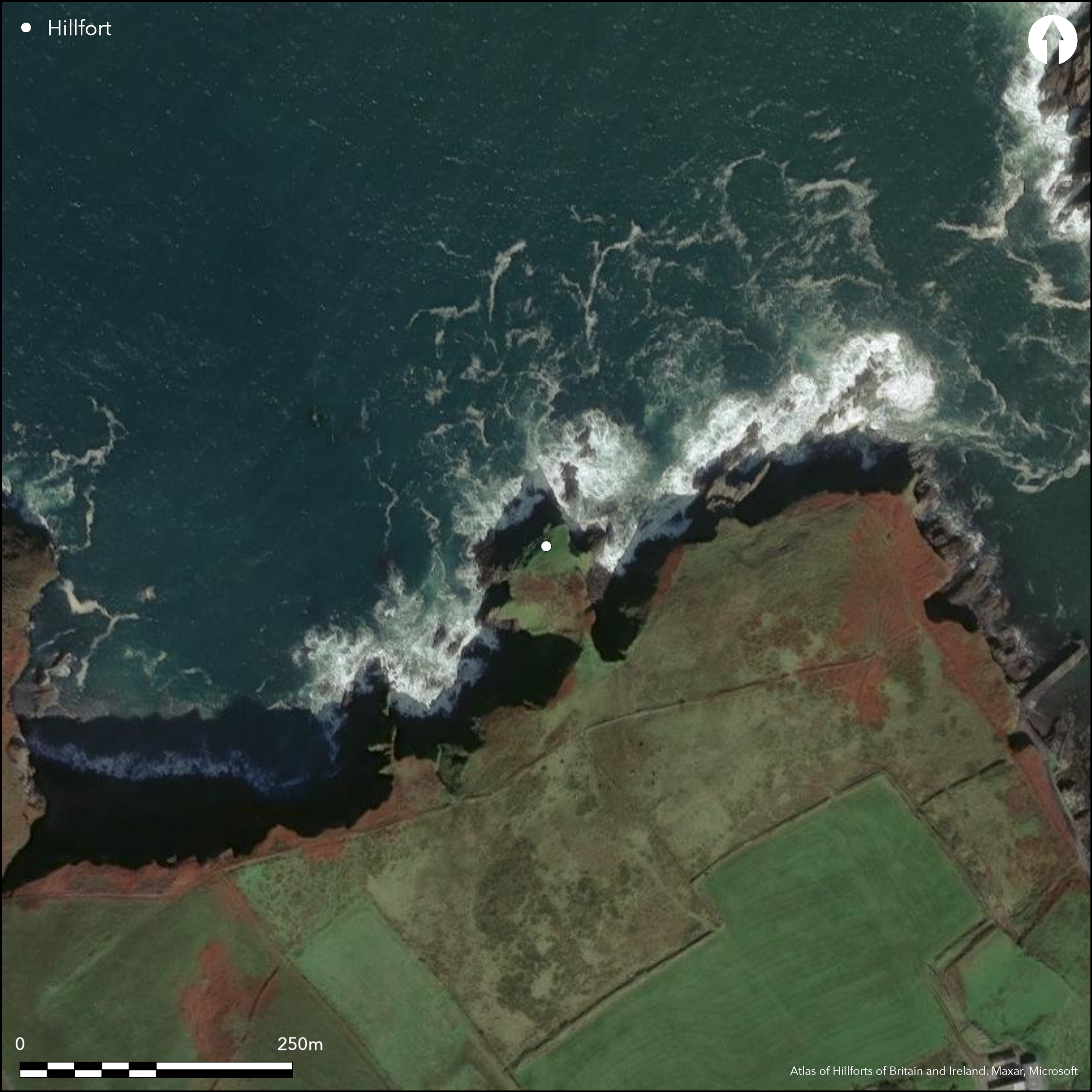
This headland, known locally as ÇDooneaner', projects N into Dingle Bay and Cooncrome Harbour at an altitude of 6m OD and is a wedge-shaped promontory joined to the mainland by a narrow neck 14m long and no more than 4.5m wide. The site is not depicted on any editions of the OS 6-inch maps. A low bank and ditch at the landward end of the neck is probably relatively modern (O'Sullivan and Sheehan 1996, 130), and the outer defences cross its spine at the seaward end of the neck, where the promontory begins to widen. The outermost is a deep, rock-cut ditch measuring 1.45m wide at the base and up to of 2.3m in depth, behind which the outer wall has a maximum basal width of 5.6m and an average height of 2m. The inner wall behind this is 1.33m high and 2.5m wide (Redmond 1995, 39). The defences are traversed by an entrance way 17m long, carried across the ditch on a causeway. About 1m in width, it has intermittent drystone facing along its sides and at its inner end two upright portal-like slabs set 1.1m apart, which were probably the jamb-stones of a formal entrance. Westropp (1912) recorded Çpiers of masonry' located on the N side of the uprights; these are no longer visible. Lady Chatterton in 1838 speculated that one of the large slabs at the entrance was the top-stone of an alter raised by an athletic race Çin adoration of their deity' (1839, 267; Redmond 1995, 39). The wedge-shaped interior, which measures about 33m from N to S by a maximum of 23m transversely at the seaward end, slopes steeply towards the sea above the cliffs on the N, and was bounded by a stone wall, traces of which remain.
Citizen Science: ✗
Reliability of Data: Confirmed
Reliability of Interpretation: Confirmed
X: -1143296 Y: 6794082 (EPSG: 3857)
Longitude: -10.270402501419667 Latitude: 51.96656205590438 (EPSG:4326)
Country: Republic of Ireland
Current County or Unitary Authority: Kerry
Historic County: Kerry
Current Parish/Community/Council/Townland: Emlagh
None
| Extant | ✓ |
| Cropmark | ✗ |
| Likely Destroyed | ✗ |
None
| Woodland | ✗ |
| Commercial Forestry Plantation | ✗ |
| Parkland | ✗ |
| Pasture (Grazing) | ✓ |
| Arable | ✗ |
| Scrub/Bracken | ✗ |
| Bare Outcrop | ✗ |
| Heather/Moorland | ✗ |
| Heath | ✗ |
| Built-up | ✗ |
| Coastal Grassland | ✗ |
| Other | ✗ |
Situated on a triangular promontory, joined to the mainland by a narrow neck that projects N into Dingle Bay at an altitude of 6m OD. Including the neck, it is 74m in overall length and for its initial 14m from the landward end it is only 4.5m wide. Beyond this, however, it increases to an average width of 10m for a further 27m before expanding into a wedge-shaped area 33m in length by a maximum of 23m transversely at the seaward end. A low bank and internal ditch located on the landward end of the neck are probably relatively modern in date. The defences lie at the seaward end of the neck.
| Contour Fort | ✗ |
| Partial Contour Fort | ✗ |
| Promontory Fort | ✓ |
| Hillslope Fort | ✗ |
| Level Terrain Fort | ✗ |
| Marsh Fort | ✗ |
| Multiple Enclosure Fort | ✗ |
| Hilltop | ✗ |
| Coastal Promontory | ✓ |
| Inland Promontory | ✗ |
| Valley Bottom | ✗ |
| Knoll/Hillock/Outcrop | ✗ |
| Ridge | ✗ |
| Cliff/Plateau-edge/Scarp | ✗ |
| Hillslope | ✗ |
| Lowland | ✗ |
| Spur | ✗ |
Dominant Topographic Feature: SW-facing promontory
| North | ✗ |
| Northeast | ✗ |
| East | ✗ |
| Southeast | ✗ |
| South | ✗ |
| Southwest | ✓ |
| West | ✗ |
| Northwest | ✗ |
| Level | ✗ |
Altitude: 6.0m
N/A
There is no dating available for the site.
Reliability: D - None
| Pre 1200BC | ✗ |
| 1200BC - 800BC | ✗ |
| 800BC - 400BC | ✗ |
| 400BC - AD50 | ✗ |
| AD50 - AD400 | ✗ |
| AD400 - AD 800 | ✗ |
| Post AD800 | ✗ |
| Unknown | ✓ |
| Pre Hillfort: | None |
| Post Hillfort: | None |
The site is not depicted on any editions of the OS 6-inch maps. Surveyed by Westropp in 1912 and visited for the compilation of the Iveragh Archaeological Inventory in the 1990s (O'Sullivan and Sheehan 1996, 128)
| 1st Identified Written Reference (1838): | Chatterton |
| Earthwork Survey (1912): | Westropp |
| Earthwork Survey (1996): | O'Sullivan and Sheehan 1996 |
There are no recorded internal features within the promontory
None
| None | ✓ |
| Spring | ✗ |
| Stream | ✗ |
| Pool | ✗ |
| Flush | ✗ |
| Well | ✗ |
| Other | ✗ |
None
| No Known Features | ✓ |
| Round Stone Structures | ✗ |
| Rectangular Stone Structures | ✗ |
| Curvilinear Platforms | ✗ |
| Other Roundhouse Evidence | ✗ |
| Pits | ✗ |
| Quarry Hollows | ✗ |
| Other | ✗ |
None
| No Known Excavation | ✓ |
| Pits | ✗ |
| Postholes | ✗ |
| Roundhouses | ✗ |
| Rectangular Structures | ✗ |
| Roads/Tracks | ✗ |
| Quarry Hollows | ✗ |
| Other | ✗ |
| Nothing Found | ✗ |
None
| No Known Geophysics | ✓ |
| Pits | ✗ |
| Roundhouses | ✗ |
| Rectangular Structures | ✗ |
| Roads/Tracks | ✗ |
| Quarry Hollows | ✗ |
| Other | ✗ |
| Nothing Found | ✗ |
None
| No Known Finds | ✓ |
| Pottery | ✗ |
| Metal | ✗ |
| Metalworking | ✗ |
| Human Bones | ✗ |
| Animal Bones | ✗ |
| Lithics | ✗ |
| Environmental | ✗ |
| Other | ✗ |
NO APPARENT FEATURES
| APs Not Checked | ✗ |
| None | ✓ |
| Roundhouses | ✗ |
| Rectangular Structures | ✗ |
| Pits | ✗ |
| Postholes | ✗ |
| Roads/Tracks | ✗ |
| Other | ✗ |
The defences are traversed by a 17m long causeway, c. 1m in width with intermittent drystone facing along the sides. At the inner wall there are two upright portal-like slabs, set 1.1m apart which were probably jamb-stones of a formal entrance. Westropp (1912) recorded Çpiers of masonry located on the N side of the uprights; these are no longer visible
| 1: | None |
| 2: | None |
Guard Chambers: ✗
Chevaux de Frise: ✗
| 1. Passage-way/Corridor (South): | None |
Defences consists of a deep, rock-cut ditch measuring 1.45m wide at the base and falling to a depth of 2.3m. Rising 4.1m above the ditch is the outer wall, which has a maximum basal width of 5.6m and an average height of 2m. Behind this wall, 3.4m away is the inner wall, 1.33m high and 2.5m wide (Redmond 1995, 39)
| Area 1: | 0.1ha. |
| Total: | 0.1ha. |
Total Footprint Area: 0.13ha.
None
| ✗ | None |
| ✗ | None |
| NE Quadrant: | 0 |
| SE Quadrant: | 2 |
| SW Quadrant: | 0 |
| NW Quadrant: | 0 |
| Total: | 2 |
| Partial Univallate | ✗ |
| Univallate | ✗ |
| Partial Bivallate | ✓ |
| Bivallate | ✗ |
| Partial Multivallate | ✗ |
| Multivallate | ✗ |
| Unknown | ✗ |
| Partial Univallate | ✗ |
| Univallate | ✗ |
| Partial Bivallate | ✗ |
| Bivallate | ✗ |
| Partial Multivallate | ✗ |
| Multivallate | ✗ |
None
| None | ✗ |
| Earthen Bank | ✗ |
| Stone Wall | ✓ |
| Rubble | ✗ |
| Wall-walk | ✗ |
| Evidence of Timber | ✗ |
| Vitrification | ✗ |
| Other Burning | ✗ |
| Palisade | ✗ |
| Counter Scarp Bank | ✗ |
| Berm | ✗ |
| Unfinished | ✗ |
| Other | ✗ |
None
| None | ✗ |
| Earthen Bank | ✗ |
| Stone Wall | ✗ |
| Murus Duplex | ✗ |
| Timber-framed | ✗ |
| Timber-laced | ✗ |
| Vitrification | ✗ |
| Other Burning | ✗ |
| Palisade | ✗ |
| Counter Scarp Bank | ✗ |
| Berm | ✗ |
| Unfinished | ✗ |
| No Known Excavation | ✓ |
| Other | ✗ |
| ✗ | None |
| ✓ | None |
Number of Ditches: 1
| ✗ | None |
O'Sullivan, A and Sheehan, J. 1996. Iveragh Peninsula: An Archaeological Survey of South Kerry. Cork University Press. Cork
Redmond, M. 1995. A survey of the promontory forts of the Kerry peninsulas. Journal of the Kerry Archaeological and Historical Society 28, 5-63.
Westropp, T.J. 1912. Notes on the promontory forts and similar structures of County Kerry. Journal of the Royal Society of Antiquaries of Ireland 42, 285-324
Atlas of Hillforts:
Wikidata:
This work is licensed under CC BY-SA 4.0

 and should be cited as:
Lock, Gary and Ralston, Ian. 2024. Atlas of Hillforts of Britain and Ireland. Available at: https://hillforts.arch.ox.ac.uk
Document Version 1.1