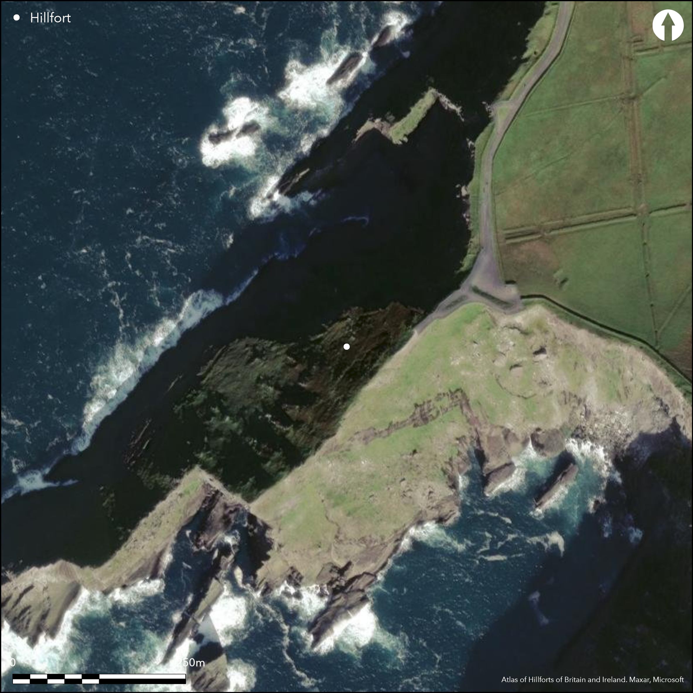
Satellite Imagery
Satellite Imagery
HER: Archaeological Survey of Ireland SMR Database KE087-047 (None)
NMR: KE 087 (None)
SM: None
NGR: None
X: 435550 Y: 570789 (IRENET95)
This rugged and inhospitable headland, known locally as ÇDromgour' (goats ridge), lies between Portmagee Channel and St. Finan's Bay in SW Co. Kerry. The promontory projects SW from its landward end for a distance of c. 260m in sharp ridge at an altitude of 40m OD, from which the rocky slopes fall away steeply along its flanks into the sea. It is not depicted on any edition of the OS six-inch maps. Access along the spine is barred by two banks at the root of the promontory, where the crest is level and some 22m wide, and a third a further 20m to the SW, where it narrows to no more than 6.8m. The outer banks average 2m in basal width and 0.8m in height and splay towards the NW; Westropp noted a substantial drystone wall surmounting the outermost (1912, 312). This was formed from large blocks that measured 1.3m long and 1m high, but it no longer survives (O'Sullivan and Sheehan 1996, 131). The third and innermost line consists of an earthen bank measuring 0.5m high by 1m in width. A break in the NW end may represent an entrance (ibid., 131). Beyond this bank rock outcrops form a natural obstacle some 26m further to the SW, and beyond this the ground simply falls away steeply to either side of the razor-backed spine. There is little occupiable space and no recorded internal features.
Citizen Science: ✗
Reliability of Data: Confirmed
Reliability of Interpretation: Confirmed
X: -1156379 Y: 6775758 (EPSG: 3857)
Longitude: -10.387927462293717 Latitude: 51.86502990700336 (EPSG:4326)
Country: Republic of Ireland
Current County or Unitary Authority: Kerry (Iveragh Peninsula)
Historic County: Kerry
Current Parish/Community/Council/Townland: Foilnageragh
None
| Extant | ✓ |
| Cropmark | ✗ |
| Likely Destroyed | ✗ |
None
| Woodland | ✗ |
| Commercial Forestry Plantation | ✗ |
| Parkland | ✗ |
| Pasture (Grazing) | ✓ |
| Arable | ✗ |
| Scrub/Bracken | ✗ |
| Bare Outcrop | ✗ |
| Heather/Moorland | ✗ |
| Heath | ✗ |
| Built-up | ✗ |
| Coastal Grassland | ✗ |
| Other | ✗ |
This coastal promontory forms a long, narrow headland projecting SW from its landward end for a distance of c. 260m at an altitude of 40m OD. It is defended by two lines of enclosing elements, positioned 35m apart spanning the 22m wide promontory neck.
| Contour Fort | ✗ |
| Partial Contour Fort | ✗ |
| Promontory Fort | ✓ |
| Hillslope Fort | ✗ |
| Level Terrain Fort | ✗ |
| Marsh Fort | ✗ |
| Multiple Enclosure Fort | ✗ |
| Hilltop | ✗ |
| Coastal Promontory | ✓ |
| Inland Promontory | ✗ |
| Valley Bottom | ✗ |
| Knoll/Hillock/Outcrop | ✗ |
| Ridge | ✗ |
| Cliff/Plateau-edge/Scarp | ✗ |
| Hillslope | ✗ |
| Lowland | ✗ |
| Spur | ✗ |
Dominant Topographic Feature: It is overlooked to the E
| North | ✗ |
| Northeast | ✗ |
| East | ✗ |
| Southeast | ✗ |
| South | ✗ |
| Southwest | ✓ |
| West | ✗ |
| Northwest | ✗ |
| Level | ✗ |
Altitude: 40.0m
N/A
There is no dating available for the site
Reliability: D - None
| Pre 1200BC | ✗ |
| 1200BC - 800BC | ✗ |
| 800BC - 400BC | ✗ |
| 400BC - AD50 | ✗ |
| AD50 - AD400 | ✗ |
| AD400 - AD 800 | ✗ |
| Post AD800 | ✗ |
| Unknown | ✓ |
| Pre Hillfort: | None |
| Post Hillfort: | None |
The site is not depicted on any editions of the OS six-inch maps. Visited and surveyed for the compilation of the Iveragh Archaeological Inventory in the 1990s (O'Sullivan and Sheehan 1996, 128).
| Earthwork Survey (1996): | O'Sullivan and Sheehan |
There are no recorded internal features
None
| None | ✓ |
| Spring | ✗ |
| Stream | ✗ |
| Pool | ✗ |
| Flush | ✗ |
| Well | ✗ |
| Other | ✗ |
None
| No Known Features | ✓ |
| Round Stone Structures | ✗ |
| Rectangular Stone Structures | ✗ |
| Curvilinear Platforms | ✗ |
| Other Roundhouse Evidence | ✗ |
| Pits | ✗ |
| Quarry Hollows | ✗ |
| Other | ✗ |
None
| No Known Excavation | ✓ |
| Pits | ✗ |
| Postholes | ✗ |
| Roundhouses | ✗ |
| Rectangular Structures | ✗ |
| Roads/Tracks | ✗ |
| Quarry Hollows | ✗ |
| Other | ✗ |
| Nothing Found | ✗ |
None
| No Known Geophysics | ✓ |
| Pits | ✗ |
| Roundhouses | ✗ |
| Rectangular Structures | ✗ |
| Roads/Tracks | ✗ |
| Quarry Hollows | ✗ |
| Other | ✗ |
| Nothing Found | ✗ |
None
| No Known Finds | ✓ |
| Pottery | ✗ |
| Metal | ✗ |
| Metalworking | ✗ |
| Human Bones | ✗ |
| Animal Bones | ✗ |
| Lithics | ✗ |
| Environmental | ✗ |
| Other | ✗ |
NO APPARENT FEATURES
| APs Not Checked | ✓ |
| None | ✗ |
| Roundhouses | ✗ |
| Rectangular Structures | ✗ |
| Pits | ✗ |
| Postholes | ✗ |
| Roads/Tracks | ✗ |
| Other | ✗ |
A break in the NW end of second enclosing element may represent an entrance. It cannot be confirmed whether this is an original feature
| 1: | None |
| 2: | A break in the NW end of the innermost bank may represent an entrance. It cannot be confirmed whether this is an original feature. |
Guard Chambers: ✗
Chevaux de Frise: ✗
Access to the promontory is barred by three banks over a distance of 35m apart, the two outer spanning the neck at the root of the promontory where it is 22m wide. These outer banks, which splay towards the NW, average 2m in basal width and 0.8m in height with Westropp noting a substantial drystone wall surmounting the outermost (1912, 312). This was formed from large blocks that measured 1.3m long and 1m high; it no longer survives (OSullivan and Sheehan 1996, 131). The innermost of the three banks occurs where the promontory is only 6.8m wide and is earthen, measuring 0.5m high by 1m in wide.
| Area 1: | 0.06ha. |
| Total: | 0.06ha. |
Total Footprint Area: 0.08ha.
None
| ✗ | None |
| ✗ | It is unclear whether any of these are the remains of ramparts (SH) |
| NE Quadrant: | 3 |
| SE Quadrant: | 0 |
| SW Quadrant: | 0 |
| NW Quadrant: | 0 |
| Total: | 3 |
| Partial Univallate | ✗ |
| Univallate | ✗ |
| Partial Bivallate | ✗ |
| Bivallate | ✗ |
| Partial Multivallate | ✓ |
| Multivallate | ✗ |
| Unknown | ✗ |
| Partial Univallate | ✗ |
| Univallate | ✗ |
| Partial Bivallate | ✗ |
| Bivallate | ✗ |
| Partial Multivallate | ✗ |
| Multivallate | ✗ |
Westropp noted a substantial drystone wall surmounting the outermost bank (1912, 312). This was formed from large blocks that measured 1.3m long and 1m high; it no longer survives.
| None | ✗ |
| Earthen Bank | ✓ |
| Stone Wall | ✗ |
| Rubble | ✗ |
| Wall-walk | ✗ |
| Evidence of Timber | ✗ |
| Vitrification | ✗ |
| Other Burning | ✗ |
| Palisade | ✗ |
| Counter Scarp Bank | ✗ |
| Berm | ✗ |
| Unfinished | ✗ |
| Other | ✗ |
None
| None | ✗ |
| Earthen Bank | ✗ |
| Stone Wall | ✗ |
| Murus Duplex | ✗ |
| Timber-framed | ✗ |
| Timber-laced | ✗ |
| Vitrification | ✗ |
| Other Burning | ✗ |
| Palisade | ✗ |
| Counter Scarp Bank | ✗ |
| Berm | ✗ |
| Unfinished | ✗ |
| No Known Excavation | ✓ |
| Other | ✗ |
| ✗ | None |
| ✗ | None |
Number of Ditches: 0
| ✗ | None |
O'Sullivan, A and Sheehan, J. 1996. Iveragh Peninsula: An Archaeological Survey of South Kerry. Cork University Press. Cork
Redmond, M. 1995. A survey of the promontory forts of the Kerry peninsulas. Journal of the Kerry Archaeological and Historical Society 28, 5-63.
Atlas of Hillforts:
Wikidata:
This work is licensed under CC BY-SA 4.0

 and should be cited as:
Lock, Gary and Ralston, Ian. 2024. Atlas of Hillforts of Britain and Ireland. Available at: https://hillforts.arch.ox.ac.uk
Document Version 1.1