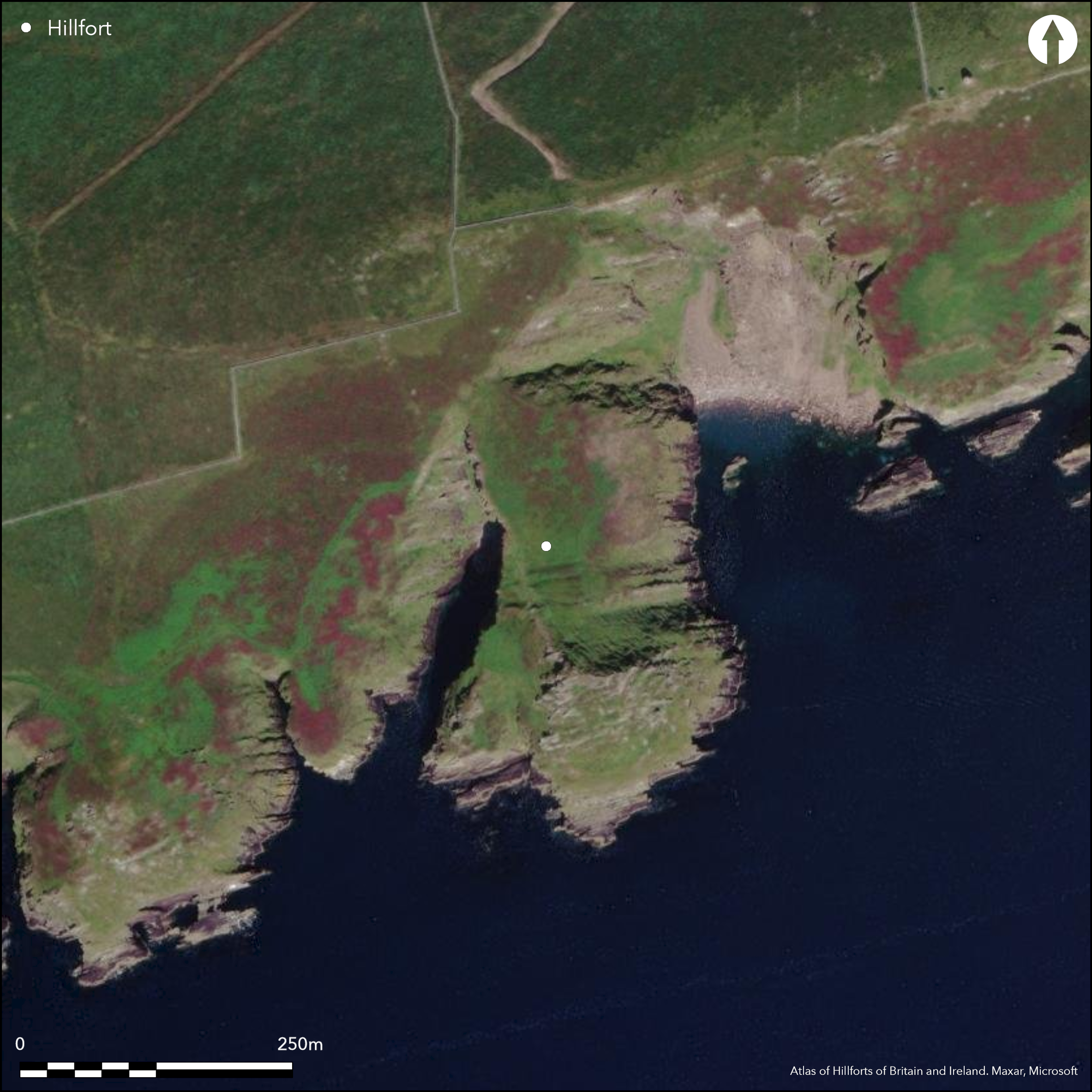
Satellite Imagery
Satellite Imagery
HER: Archaeological Survey of Ireland SMR Database KE053-067 (None)
NMR: KE 053 (None)
SM: None
NGR: None
X: 443495 Y: 598167 (IRENET95)
This headland, described by Westropp as ÇDoon Eask' is located on a secluded cliff behind Ballymacadoyle Hill, S of Dingle Harbour, Co. Kerry. A spit of land, projecting S from the mainland, it has is defended by two widely-spaced lines of enclosing elements at an altitude of 47m OD. Both appear on earlier editions of OS 6-inch and 25-inch maps (1840). The first line of defence is a wall, situated on the highest point of the headland, where it springs from the mainland at a narrow neck formed between deep ravines. This wall is c. 3m wide, composed of large blocks and swings round cliff edge on the E enclosing the S facing slope dropping down into the promontory from the neck (Redmond 1995, 12; O'Sullivan and Sheehan 1996, 83). The ground falls away for a distance of about 100m into a saddle from which it rises again into a rocky summit. The second set of defences lies at the base of this slope, comprising an inner wall and three banks and ditches drawn through the saddle over a distance of about 45m. The inner wall is fronted by a deep ditch and a counterscarp bank. The wall has incorporated a mostly sheer rock outcrop, which has been augmented by dry-stone walling 5.5m wide surviving to a maximum of 1.75m high in eleven courses. The ditch is 5.7m wide and 0.97m deep while the counterscarp bank is 0.4m wide. The outer two banks and large ditches of this set of defences are set at an angle to the inner wall, converging towards the W, which may indicate that they represent a separate phase of construction. Towards the W end, a causeway c. 3m in length and 2m wide pierces the defences, and the terminals of both the outer ramparts and their ditches are staggered to either side of the gap. The interior of the fort rises in natural terraces to the rocky summit. About mid-way down the slope on the S side, a line of upright slabs runs E-W across the slope and it is possible that these represent a burial ground recorded in the OS Name Book. Two slabs lying outside the E end of the outer ditch are marked as a ÇGiants Grave' on the OS maps, but any interpretation as a megalithic tomb has been treated with caution by De Valera and î Nuall_in (1982, 70).
Citizen Science: ✗
Reliability of Data: Confirmed
Reliability of Interpretation: Confirmed
X: -1144938 Y: 6820623 (EPSG: 3857)
Longitude: -10.285150194643018 Latitude: 52.11321991918487 (EPSG:4326)
Country: Republic of Ireland
Current County or Unitary Authority: Kerry
Historic County: Kerry
Current Parish/Community/Council/Townland: Ballymacadoyle
None
| Extant | ✓ |
| Cropmark | ✗ |
| Likely Destroyed | ✗ |
None
| Woodland | ✗ |
| Commercial Forestry Plantation | ✗ |
| Parkland | ✗ |
| Pasture (Grazing) | ✓ |
| Arable | ✗ |
| Scrub/Bracken | ✗ |
| Bare Outcrop | ✗ |
| Heather/Moorland | ✗ |
| Heath | ✗ |
| Built-up | ✗ |
| Coastal Grassland | ✗ |
| Other | ✗ |
This coastal promontory is located on a secluded cliff behind Ballymacadoyle Hill, S of Dingle Harbour in Co. Kerry. It is situated on a spit of land, projecting S from the mainland at an altitude of 47m OD. It is defended by two lines of enclosing elements. The interior of the fort rises in natural terraces to a rocky pinnacle
| Contour Fort | ✗ |
| Partial Contour Fort | ✗ |
| Promontory Fort | ✓ |
| Hillslope Fort | ✗ |
| Level Terrain Fort | ✗ |
| Marsh Fort | ✗ |
| Multiple Enclosure Fort | ✗ |
| Hilltop | ✗ |
| Coastal Promontory | ✓ |
| Inland Promontory | ✗ |
| Valley Bottom | ✗ |
| Knoll/Hillock/Outcrop | ✗ |
| Ridge | ✗ |
| Cliff/Plateau-edge/Scarp | ✗ |
| Hillslope | ✗ |
| Lowland | ✗ |
| Spur | ✗ |
Dominant Topographic Feature: The site is overlooked to the N
| North | ✗ |
| Northeast | ✗ |
| East | ✗ |
| Southeast | ✗ |
| South | ✓ |
| Southwest | ✗ |
| West | ✗ |
| Northwest | ✗ |
| Level | ✗ |
Altitude: 47.0m
N/A
There is no dating available for the site
Reliability: D - None
| Pre 1200BC | ✗ |
| 1200BC - 800BC | ✗ |
| 800BC - 400BC | ✗ |
| 400BC - AD50 | ✗ |
| AD50 - AD400 | ✗ |
| AD400 - AD 800 | ✗ |
| Post AD800 | ✗ |
| Unknown | ✓ |
| Pre Hillfort: | None |
| Post Hillfort: | One ledge has a series of small upright stones around its edge; the Dingle Survey suggests that this is the 'Burial Ground with headstones' mentioned in the OS Name Books. |
Promontory depicted on the first edition OS six-inch map (1840). Defences are marked on the second edition six-inch and twenty-five-inch map (1895). Surveyd by Westropp in 1910 and site was was visited and planned by Augustus H. Lane-Fox, later known as A. H. Pitt-Rivers in 1865 (Twohig 1987, 36). Visited and surveyed for the compilation of the Iveragh Archaeological Inventory in the 1990s (O'Sullivan and Sheehan 1996, 128)
| 1st Identified Map Depiction (1840): | First edition 6-inch map |
| Earthwork Survey (1865): | Pitt-Rivers (Twohig 1987) |
| Earthwork Survey (1910): | Westropp |
| Other (1986): | Cuppage |
| Earthwork Survey (1996): | O'Sullivan and Sheehan 1996 |
About mid-way down the slope on the S side, a line of upright slabs runs E-W across the slope and it is possible that these represent a burial ground recorded in the OS Namebooks. Two slabs lying outside the E end of the outer ditch are marked as a ÇGiants Grave on the OS maps, but these have been treated with caution by De Valera and î Nuall_in 1982, 70)
None
| None | ✓ |
| Spring | ✗ |
| Stream | ✗ |
| Pool | ✗ |
| Flush | ✗ |
| Well | ✗ |
| Other | ✗ |
Upright stones, possible later burial ground.
| No Known Features | ✗ |
| Round Stone Structures | ✗ |
| Rectangular Stone Structures | ✗ |
| Curvilinear Platforms | ✗ |
| Other Roundhouse Evidence | ✗ |
| Pits | ✗ |
| Quarry Hollows | ✗ |
| Other | ✓ |
None
| No Known Excavation | ✓ |
| Pits | ✗ |
| Postholes | ✗ |
| Roundhouses | ✗ |
| Rectangular Structures | ✗ |
| Roads/Tracks | ✗ |
| Quarry Hollows | ✗ |
| Other | ✗ |
| Nothing Found | ✗ |
None
| No Known Geophysics | ✓ |
| Pits | ✗ |
| Roundhouses | ✗ |
| Rectangular Structures | ✗ |
| Roads/Tracks | ✗ |
| Quarry Hollows | ✗ |
| Other | ✗ |
| Nothing Found | ✗ |
None
| No Known Finds | ✓ |
| Pottery | ✗ |
| Metal | ✗ |
| Metalworking | ✗ |
| Human Bones | ✗ |
| Animal Bones | ✗ |
| Lithics | ✗ |
| Environmental | ✗ |
| Other | ✗ |
NO APPARENT FEATURES
| APs Not Checked | ✓ |
| None | ✗ |
| Roundhouses | ✗ |
| Rectangular Structures | ✗ |
| Pits | ✗ |
| Postholes | ✗ |
| Roads/Tracks | ✗ |
| Other | ✗ |
Towards the W end, a causeway c. 3m in length and 2m wide pierces the defences. It cannot be confirmed whether this is original.
| 1: | None |
| 2: | None |
Guard Chambers: ✗
Chevaux de Frise: ✗
| 1. Other Forms (North): | Ramparts and ditch terminals staggered to either side of the gap |
The first line of defence is a wall, at the narrow neck at the top of the slope dropping into the promontory. This wall is c. 3m wide, composed of large blocks and curves around the E cliff edge enclosing the slope of the hill above a shallow saddle (Redmond 1995, 12; OSullivan and Sheehan 1996, 83). At the base of the slope dropping into this saddle, a wall and three banks and ditches extend 45m across the promontory. The innermost consists of the wall fronted by a deep ditch and a counterscarp bank. The wall incorporates a mostly of sheer rock outcrop, which has been augmented with dry-stone walling standing to a maximum height of eleven courses in 1.75m. The ditch is 5.7m wide and 0.97m deep while the couterscarp bank is 0.4m wide. Two further banks and large ditches are recorded at an angle to the previous defences separated on the E by a triangular area up to 6.1m wide.
| Area 1: | 1.69ha. |
| Total: | 1.69ha. |
Total Footprint Area: 2.1ha.
None
| ✓ | The innermost wall and its ditch appear to cut across the line of the two outer banks and ditches |
| ✗ | None |
| NE Quadrant: | 3 |
| SE Quadrant: | 0 |
| SW Quadrant: | 0 |
| NW Quadrant: | 0 |
| Total: | 3 |
| Partial Univallate | ✗ |
| Univallate | ✗ |
| Partial Bivallate | ✗ |
| Bivallate | ✗ |
| Partial Multivallate | ✓ |
| Multivallate | ✗ |
| Unknown | ✗ |
| Partial Univallate | ✗ |
| Univallate | ✗ |
| Partial Bivallate | ✗ |
| Bivallate | ✗ |
| Partial Multivallate | ✗ |
| Multivallate | ✗ |
None
| None | ✗ |
| Earthen Bank | ✓ |
| Stone Wall | ✓ |
| Rubble | ✗ |
| Wall-walk | ✗ |
| Evidence of Timber | ✗ |
| Vitrification | ✗ |
| Other Burning | ✗ |
| Palisade | ✗ |
| Counter Scarp Bank | ✓ |
| Berm | ✗ |
| Unfinished | ✗ |
| Other | ✗ |
None
| None | ✗ |
| Earthen Bank | ✗ |
| Stone Wall | ✗ |
| Murus Duplex | ✗ |
| Timber-framed | ✗ |
| Timber-laced | ✗ |
| Vitrification | ✗ |
| Other Burning | ✗ |
| Palisade | ✗ |
| Counter Scarp Bank | ✗ |
| Berm | ✗ |
| Unfinished | ✗ |
| No Known Excavation | ✓ |
| Other | ✗ |
| ✗ | None |
| ✓ | None |
Number of Ditches: 3
| ✗ | None |
Cuppage, J 1986 «Corca Dhuibhne. Dingle Peninsula archaeological survey. Ballyferriter. Oidhreacht Chorca Dhuibhne» (1986), no. 262
O'Sullivan, A and Sheehan, J. 1996. Iveragh Peninsula: An Archaeological Survey of South Kerry. Cork University Press. Cork
Redmond, M. 1995. A survey of the promontory forts of the Kerry peninsulas. Journal of the Kerry Archaeological and Historical Society 28, 5-63.
Twohig, E. 1987. Pitt-Rivers in Munster 1862-65/6. Journal of the Cork Historical and Archaeological Society 92, 34-46.
Westropp, T.J. 1910. Promontory forts and similar structures of County Kerry. Journal of the Royal Society of Antiquaries of Ireland 40, 179-213, 265-196.
Atlas of Hillforts:
Wikidata:
This work is licensed under CC BY-SA 4.0

 and should be cited as:
Lock, Gary and Ralston, Ian. 2024. Atlas of Hillforts of Britain and Ireland. Available at: https://hillforts.arch.ox.ac.uk
Document Version 1.1