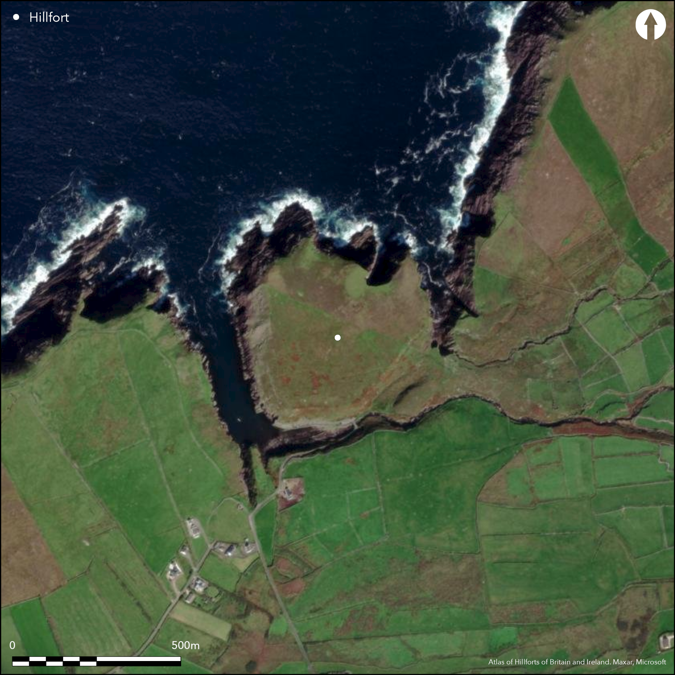
Satellite Imagery
Satellite Imagery
HER: Archaeological Survey of Ireland SMR Database KE034-001 (None)
NMR: KE 034 (None)
SM: None
NGR: None
X: 442319 Y: 612230 (IRENET95)
This coastal promontory, known locally as ÇAn D–n Rua', is located close to Mount Brandon between two narrow inlets at Brandon Creek, Co. Kerry. It is situated at an altitude of 36m OD and is named 'Doonroe' on the first edition OS six-inch map. It is a large promontory (c. 6.9ha), separated from the mainland by a natural valley between two inlets; Coosatana and Coosavuddig. This natural defence has been augmented by a stone wall along its upper edge, traced by Westropp for over 120m and described as '12 to 15 feet thick' (1910, 190-2). This is best preserved for a distance of c. 55m from the NE end, where it is up to 1.55m high (Redmond 1995, 16). While the wall is in poor condition, it is evident that it consisted of two dry-stone revetments, separated by a 5m wide ledge or berm (O'Sullivan and Sheehan 1996, 87). There is no evidence of internal facing with most sections reduced to collapsed, unfaced scarps. To the SW of the entrance an outer wall lies c. 4.6m downslope and is 12m long. The entrance lies 40m SW of the cliff-edge on the NE, cutting at right angles across the defences for a length of 13m and varying from 3m to 10m in width. The sides of the entrance were lined with upright slabs, which also line the terminals of the walls, though only a small number remain in situ. There are a number of recorded features within the interior of the promontory. Westropp recorded one enclosure abutting the wall about 10m from the entrance, though this is no longer visible, and a second on the SW of the promontory; the latter measures 43m by 36m and has an entrance to the NE defined by two upright slabs set 0.9m apart. At the E end of its S side is a modern sheep-shelter and turf shed. Most of the interior is covered in upland bog.
Citizen Science: ✗
Reliability of Data: Confirmed
Reliability of Interpretation: Confirmed
X: -1147575 Y: 6843490 (EPSG: 3857)
Longitude: -10.308839863731578 Latitude: 52.23919182718802 (EPSG:4326)
Country: Republic of Ireland
Current County or Unitary Authority: Kerry
Historic County: Kerry
Current Parish/Community/Council/Townland: Ballynahow
None
| Extant | ✓ |
| Cropmark | ✗ |
| Likely Destroyed | ✗ |
None
| Woodland | ✗ |
| Commercial Forestry Plantation | ✗ |
| Parkland | ✗ |
| Pasture (Grazing) | ✗ |
| Arable | ✗ |
| Scrub/Bracken | ✗ |
| Bare Outcrop | ✗ |
| Heather/Moorland | ✓ |
| Heath | ✗ |
| Built-up | ✗ |
| Coastal Grassland | ✗ |
| Other | ✗ |
This coastal promontory is located close to Mount Brandon between two narrow inlets at Brandon Creek, Co. Kerry. It is a large promontory, about 300m square, separated from the mainland by a natural valley between the two inlets Coosatana and Coosavuddig. This natural defence has been augmented by a stone wall along its upper edge
| Contour Fort | ✗ |
| Partial Contour Fort | ✗ |
| Promontory Fort | ✓ |
| Hillslope Fort | ✗ |
| Level Terrain Fort | ✗ |
| Marsh Fort | ✗ |
| Multiple Enclosure Fort | ✗ |
| Hilltop | ✗ |
| Coastal Promontory | ✓ |
| Inland Promontory | ✗ |
| Valley Bottom | ✗ |
| Knoll/Hillock/Outcrop | ✗ |
| Ridge | ✗ |
| Cliff/Plateau-edge/Scarp | ✗ |
| Hillslope | ✗ |
| Lowland | ✗ |
| Spur | ✗ |
Dominant Topographic Feature: None
| North | ✓ |
| Northeast | ✗ |
| East | ✗ |
| Southeast | ✗ |
| South | ✗ |
| Southwest | ✗ |
| West | ✗ |
| Northwest | ✗ |
| Level | ✗ |
Altitude: 36.0m
N/A
There is no dating available for the site
Reliability: D - None
| Pre 1200BC | ✗ |
| 1200BC - 800BC | ✗ |
| 800BC - 400BC | ✗ |
| 400BC - AD50 | ✗ |
| AD50 - AD400 | ✗ |
| AD400 - AD 800 | ✗ |
| Post AD800 | ✗ |
| Unknown | ✓ |
| Pre Hillfort: | None |
| Post Hillfort: | None |
The site is not depicted on any editions of the OS six-inch maps although it is named 'Doonroe' on the first edition OS six-inch map. Surveyed by Westropp in 1910, and visited for the Dingle Peninsula Archaeological Survey in the mid-1980s (Cuppage et al. 1986)
| 1st Identified Written Reference (1910): | Westropp |
| Earthwork Survey (1986): | Cuppage |
| Other (1996): | O'Sullivan and Sheehan 1996 |
Westropp recorded an enclosure abutting the wall about 10m from the entrance but this is no longer visible. Another enclosure however is recorded measuring 43m by 36m on the SW of the promontory, with an entrance NE defined by two upright slabs set 0.9m apart. At the E end of the S side is a modern sheep-shelter and turf shed
None
| None | ✓ |
| Spring | ✗ |
| Stream | ✗ |
| Pool | ✗ |
| Flush | ✗ |
| Well | ✗ |
| Other | ✗ |
Enclosure
| No Known Features | ✗ |
| Round Stone Structures | ✗ |
| Rectangular Stone Structures | ✗ |
| Curvilinear Platforms | ✗ |
| Other Roundhouse Evidence | ✗ |
| Pits | ✗ |
| Quarry Hollows | ✗ |
| Other | ✓ |
None
| No Known Excavation | ✓ |
| Pits | ✗ |
| Postholes | ✗ |
| Roundhouses | ✗ |
| Rectangular Structures | ✗ |
| Roads/Tracks | ✗ |
| Quarry Hollows | ✗ |
| Other | ✗ |
| Nothing Found | ✗ |
None
| No Known Geophysics | ✓ |
| Pits | ✗ |
| Roundhouses | ✗ |
| Rectangular Structures | ✗ |
| Roads/Tracks | ✗ |
| Quarry Hollows | ✗ |
| Other | ✗ |
| Nothing Found | ✗ |
None
| No Known Finds | ✓ |
| Pottery | ✗ |
| Metal | ✗ |
| Metalworking | ✗ |
| Human Bones | ✗ |
| Animal Bones | ✗ |
| Lithics | ✗ |
| Environmental | ✗ |
| Other | ✗ |
NO APPARENT FEATURES
| APs Not Checked | ✓ |
| None | ✗ |
| Roundhouses | ✗ |
| Rectangular Structures | ✗ |
| Pits | ✗ |
| Postholes | ✗ |
| Roads/Tracks | ✗ |
| Other | ✗ |
The entrance cuts at right angles across the defences for a length of 13m and varies from 3m to 10m in width. The sides of the entrance were lined with upright slabs and these also form the terminals of the walls. Only a small number remain in situ
| 1: | None |
| 2: | None |
Guard Chambers: ✗
Chevaux de Frise: ✗
| 1. Passage-way/Corridor (South): | The sides of the entrance were lined with upright slabs which also form the terminals of the walls |
The naturally defended headland is augmented by a stone wall along its upper edge, traced by Westropp for over 120m and described as 12 to 15 feet thick (1910, 190-2). This is best preserved for c. 55m from the NE end, where it is up to 1.55m high (Redmond 1995, 16). While the wall is in poor condition, it is evident that it consisted of two dry-stone revetments separated by a 5m wide ledge or berm (OSullivan and Sheehan 1996, 87). There is no evidence of internal facing with most sections surviving as collapsed, unfaced scarps.
| Area 1: | 6.89ha. |
| Total: | 6.89ha. |
Total Footprint Area: 6.91ha.
None
| ✗ | None |
| ✗ | None |
| NE Quadrant: | 0 |
| SE Quadrant: | 1 |
| SW Quadrant: | 0 |
| NW Quadrant: | 0 |
| Total: | 1 |
| Partial Univallate | ✓ |
| Univallate | ✗ |
| Partial Bivallate | ✗ |
| Bivallate | ✗ |
| Partial Multivallate | ✗ |
| Multivallate | ✗ |
| Unknown | ✗ |
| Partial Univallate | ✗ |
| Univallate | ✗ |
| Partial Bivallate | ✗ |
| Bivallate | ✗ |
| Partial Multivallate | ✗ |
| Multivallate | ✗ |
None
| None | ✗ |
| Earthen Bank | ✗ |
| Stone Wall | ✗ |
| Rubble | ✓ |
| Wall-walk | ✗ |
| Evidence of Timber | ✗ |
| Vitrification | ✗ |
| Other Burning | ✗ |
| Palisade | ✗ |
| Counter Scarp Bank | ✗ |
| Berm | ✗ |
| Unfinished | ✗ |
| Other | ✗ |
None
| None | ✗ |
| Earthen Bank | ✗ |
| Stone Wall | ✗ |
| Murus Duplex | ✗ |
| Timber-framed | ✗ |
| Timber-laced | ✗ |
| Vitrification | ✗ |
| Other Burning | ✗ |
| Palisade | ✗ |
| Counter Scarp Bank | ✗ |
| Berm | ✗ |
| Unfinished | ✗ |
| No Known Excavation | ✓ |
| Other | ✗ |
| ✗ | None |
| ✗ | None |
Number of Ditches: 0
| ✗ | None |
Cuppage, J. et al. 1986. Archaeological Survey of the Dingle Peninsula. Ballyferriter
O'Sullivan, A and Sheehan, J. 1996. Iveragh Peninsula: An Archaeological Survey of South Kerry. Cork University Press. Cork
Redmond, M. 1995. A survey of the promontory forts of the Kerry peninsulas. Journal of the Kerry Archaeological and Historical Society 28, 5-63.
Westropp, T.J. 1910. Promontory forts and similar structures of County Kerry. Journal of the Royal Society of Antiquaries of Ireland 40, 179-213, 265-196
Atlas of Hillforts:
Wikidata:
This work is licensed under CC BY-SA 4.0

 and should be cited as:
Lock, Gary and Ralston, Ian. 2024. Atlas of Hillforts of Britain and Ireland. Available at: https://hillforts.arch.ox.ac.uk
Document Version 1.1