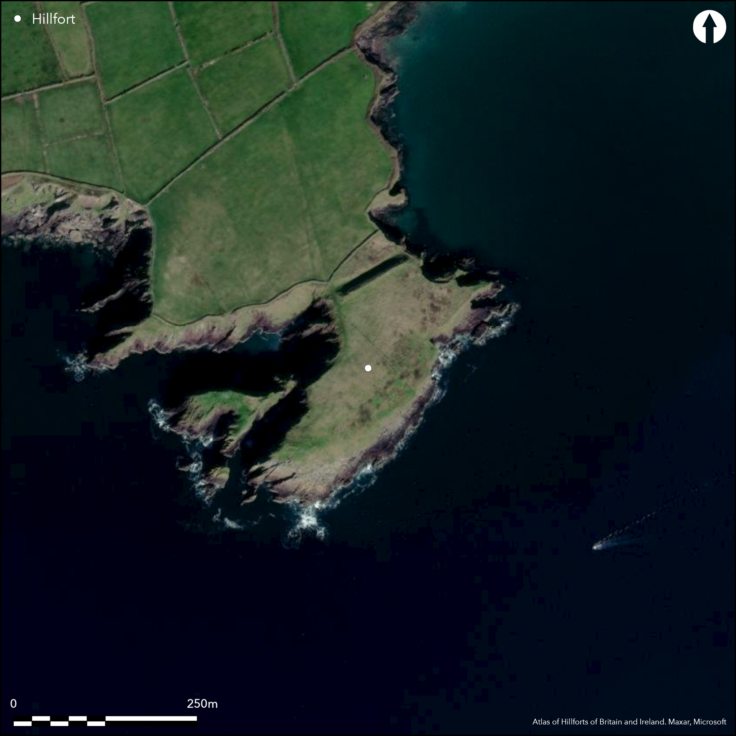
Satellite Imagery
Satellite Imagery
HER: Archaeological Survey of Ireland SMR Database KE053-079001 (None)
NMR: KE 053 (None)
SM: None
NGR: None
X: 447849 Y: 598655 (IRENET95)
This large promontory is situated on the W side of the entrance to Trabeg, projecting SE into Dingle Bay at an altitude of 15m OD. Although Westropp refers to the site as Dunsheane (1910, 286-7), the greater portion of the promontory fort is known as Doonmore. Doonbeg is the name given to a smaller, inaccessible projection on the W, forming the S side of a narrow inlet of the sea, cutting deep into the S side of the promontory (O'Sullivan and Sheehan 1996, 90). The headland is defended by a bank and ditch that extend 75m across the neck on the landward side. The ditch is 9.1m wide and 3.05m deep while the bank is recorded as 10m wide at the base, 3m high internally and 6.6m above the base of the ditch (O'Sullivan and Sheehan 1996, 90; Redmond 1995, 21). A stone wall, composed of large horizontally-laid slabs is intermittently visible along the top of the earthen bank. This wall is 2-3 courses high and 2.6m wide. A causeway is recorded at the W end of the defences, 5m from the W cliff edge, while on the E the bank terminates 4.4m short of the cliff edge; Westropp recorded an 'old looking gateway' here. The stumps of two pillar stones stand 1.5m apart at this point, but Redmond notes that they are incorrectly aligned to have functioned as gate pillars through the defences (1995, 21). A possible souterrain is recorded inside the bank, c. 11m from the causeway (Westropp 1910, 287). It is marked by a hole, some large stones and subsidence of the bank (O'Sullivan and Sheehan 1996, 90). Within the interior, Westropp recorded three hut-sites, and though these are not apparent today, five further examples have been noted closely grouped near the cliff edge to the SW field boundary that cuts across the middle of the interior. They are composed of circular depressions cut into the sloping ground on one side and enclosed by a low bank on the other. The smaller, subsidiary headland known as D–n Beag, which is triangular, measuring 23m by 25m by 18m and enclosed by a bank; Westropp also noted traces of a ditch above the neck linking it to the foot of the main promontory. There are no recorded internal features on the summit.
Citizen Science: ✗
Reliability of Data: Confirmed
Reliability of Interpretation: Confirmed
X: -1137891 Y: 6821638 (EPSG: 3857)
Longitude: -10.2218473556722 Latitude: 52.11881765297516 (EPSG:4326)
Country: Republic of Ireland
Current County or Unitary Authority: Kerry
Historic County: Kerry
Current Parish/Community/Council/Townland: Doonsheane
None
| Extant | ✓ |
| Cropmark | ✗ |
| Likely Destroyed | ✗ |
None
| Woodland | ✗ |
| Commercial Forestry Plantation | ✗ |
| Parkland | ✗ |
| Pasture (Grazing) | ✓ |
| Arable | ✗ |
| Scrub/Bracken | ✗ |
| Bare Outcrop | ✗ |
| Heather/Moorland | ✗ |
| Heath | ✗ |
| Built-up | ✗ |
| Coastal Grassland | ✗ |
| Other | ✗ |
This coastal promontory is situated on the W side of the entrance to Trabeg, projecting SE into Dingle Bay at an altitude of 15m OD. The headland is defended by a bank and ditch that extend 75m across the neck on the landward side.
| Contour Fort | ✗ |
| Partial Contour Fort | ✗ |
| Promontory Fort | ✓ |
| Hillslope Fort | ✗ |
| Level Terrain Fort | ✗ |
| Marsh Fort | ✗ |
| Multiple Enclosure Fort | ✗ |
| Hilltop | ✗ |
| Coastal Promontory | ✓ |
| Inland Promontory | ✗ |
| Valley Bottom | ✗ |
| Knoll/Hillock/Outcrop | ✗ |
| Ridge | ✗ |
| Cliff/Plateau-edge/Scarp | ✗ |
| Hillslope | ✗ |
| Lowland | ✗ |
| Spur | ✗ |
Dominant Topographic Feature: SE-facing promontory
| North | ✗ |
| Northeast | ✗ |
| East | ✗ |
| Southeast | ✓ |
| South | ✗ |
| Southwest | ✗ |
| West | ✗ |
| Northwest | ✗ |
| Level | ✗ |
Altitude: 15.0m
N/A
There is no dating available for the site
Reliability: D - None
| Pre 1200BC | ✗ |
| 1200BC - 800BC | ✗ |
| 800BC - 400BC | ✗ |
| 400BC - AD50 | ✗ |
| AD50 - AD400 | ✗ |
| AD400 - AD 800 | ✗ |
| Post AD800 | ✗ |
| Unknown | ✓ |
| Pre Hillfort: | None |
| Post Hillfort: | None |
The site is recorded on the first edition six-inch OS map (1841). Visited and surveyed by Thomas Westropp in 1910 who recorded defences and internal hut-structures. Site later surveyed by the Dingle Survey (Cuppage 1986, 90).
| 1st Identified Map Depiction (1840): | OS six-inch mapping |
| 1st Identified Written Reference (1910): | Westropp |
| Earthwork Survey (1986): | Cuppage |
| Earthwork Survey (1996): | O'Sullivan and Sheeehan 1996 |
A possible souterrain is recorded inside the bank, c. 11m from the causeway (Westropp 1910, 287). It is marked by a hole, some large stones and subsidence of the bank (O'Sullivan and Sheehan 1996, 90). Within the interior, Westropp recorded three hut-sites, but these are not apparent today. Nevertheless, five further examples have been noted closely grouped near the cliff edge to the SW of a field boundary that cuts across the interior. They coprise circular depressions cut into the sloping ground on one side and enclosed by a low bank on the other. They range in diameter from 3 to 5.5m.
None
| None | ✓ |
| Spring | ✗ |
| Stream | ✗ |
| Pool | ✗ |
| Flush | ✗ |
| Well | ✗ |
| Other | ✗ |
None
| No Known Features | ✗ |
| Round Stone Structures | ✗ |
| Rectangular Stone Structures | ✗ |
| Curvilinear Platforms | ✗ |
| Other Roundhouse Evidence | ✓ |
| Pits | ✗ |
| Quarry Hollows | ✗ |
| Other | ✗ |
None
| No Known Excavation | ✓ |
| Pits | ✗ |
| Postholes | ✗ |
| Roundhouses | ✗ |
| Rectangular Structures | ✗ |
| Roads/Tracks | ✗ |
| Quarry Hollows | ✗ |
| Other | ✗ |
| Nothing Found | ✗ |
None
| No Known Geophysics | ✓ |
| Pits | ✗ |
| Roundhouses | ✗ |
| Rectangular Structures | ✗ |
| Roads/Tracks | ✗ |
| Quarry Hollows | ✗ |
| Other | ✗ |
| Nothing Found | ✗ |
None
| No Known Finds | ✓ |
| Pottery | ✗ |
| Metal | ✗ |
| Metalworking | ✗ |
| Human Bones | ✗ |
| Animal Bones | ✗ |
| Lithics | ✗ |
| Environmental | ✗ |
| Other | ✗ |
NO APPARENT FEATURES
| APs Not Checked | ✗ |
| None | ✓ |
| Roundhouses | ✗ |
| Rectangular Structures | ✗ |
| Pits | ✗ |
| Postholes | ✗ |
| Roads/Tracks | ✗ |
| Other | ✗ |
Causeway across the ditch at the WSW end of the defences. On the ENE the bank stops 4.4m short of the cliff edge, where Westropp recorded an 'old looking gateway' and the stumps of two pillar stones stand 1.5m apart at this point; Redmond, however, notes that they are incorrectly aligned to have functioned as gate pillars through the defences (1995, 21)
| 2: | None |
| 2: | None |
Guard Chambers: ✗
Chevaux de Frise: ✗
| 1. Simple Gap (North west): | A causeway is recorded at the W end of the defences, 5m from the W cliff edge |
The headland is defended by a bank and ditch that extend 75m across the neck on the landward side. The ditch is 9.1m wide and 3.05m deep, while the bank is 10m wide at the base, 3m high internally and stands 6.6m above the base of the ditch (O'Sullivan and Sheehan 1996, 90; Redmond 1995, 21). A stone wal of large horizontally-laid slabs is intermittently visible on top of the earthen bank. This wall is 2-3 courses high and 2.6m wide. Accompanying the ditch to the W of the W entrance causeway is no more than a large boulder. The bank does also stops 4.4m short of the cliff-edge on the E.
| Area 1: | 1.37ha. |
| Total: | 1.37ha. |
Total Footprint Area: 1.6ha.
None
| ✗ | Located between this promontory fort and the mainland is a smaller, subsidiary headland known as Dñn Beag. This has an overall site footprint of 0.16ha. |
| ✗ | None |
| NE Quadrant: | 1 |
| SE Quadrant: | 0 |
| SW Quadrant: | 0 |
| NW Quadrant: | 0 |
| Total: | 1 |
| Partial Univallate | ✓ |
| Univallate | ✗ |
| Partial Bivallate | ✗ |
| Bivallate | ✗ |
| Partial Multivallate | ✗ |
| Multivallate | ✗ |
| Unknown | ✗ |
| Partial Univallate | ✗ |
| Univallate | ✗ |
| Partial Bivallate | ✗ |
| Bivallate | ✗ |
| Partial Multivallate | ✗ |
| Multivallate | ✗ |
None
| None | ✗ |
| Earthen Bank | ✓ |
| Stone Wall | ✓ |
| Rubble | ✗ |
| Wall-walk | ✗ |
| Evidence of Timber | ✗ |
| Vitrification | ✗ |
| Other Burning | ✗ |
| Palisade | ✗ |
| Counter Scarp Bank | ✗ |
| Berm | ✗ |
| Unfinished | ✗ |
| Other | ✗ |
None
| None | ✗ |
| Earthen Bank | ✗ |
| Stone Wall | ✗ |
| Murus Duplex | ✗ |
| Timber-framed | ✗ |
| Timber-laced | ✗ |
| Vitrification | ✗ |
| Other Burning | ✗ |
| Palisade | ✗ |
| Counter Scarp Bank | ✗ |
| Berm | ✗ |
| Unfinished | ✗ |
| No Known Excavation | ✓ |
| Other | ✗ |
| ✗ | None |
| ✓ | None |
Number of Ditches: 1
| ✗ | None |
Cuppage, J. et al. 1986. Archaeological Survey of the Dingle Peninsula. Ballyferriter
O'Sullivan, A and Sheehan, J. 1996. Iveragh Peninsula: An Archaeological Survey of South Kerry. Cork University Press. Cork
Redmond, M. 1995. A survey of the promontory forts of the Kerry peninsulas. Journal of the Kerry Archaeological and Historical Society 28, 5-63.
Westropp, T.J. 1910. Promontory forts and similar structures of County Kerry. Journal of the Royal Society of Antiquaries of Ireland 40, 179-213, 265-196
Atlas of Hillforts:
Wikidata:
This work is licensed under CC BY-SA 4.0

 and should be cited as:
Lock, Gary and Ralston, Ian. 2024. Atlas of Hillforts of Britain and Ireland. Available at: https://hillforts.arch.ox.ac.uk
Document Version 1.1