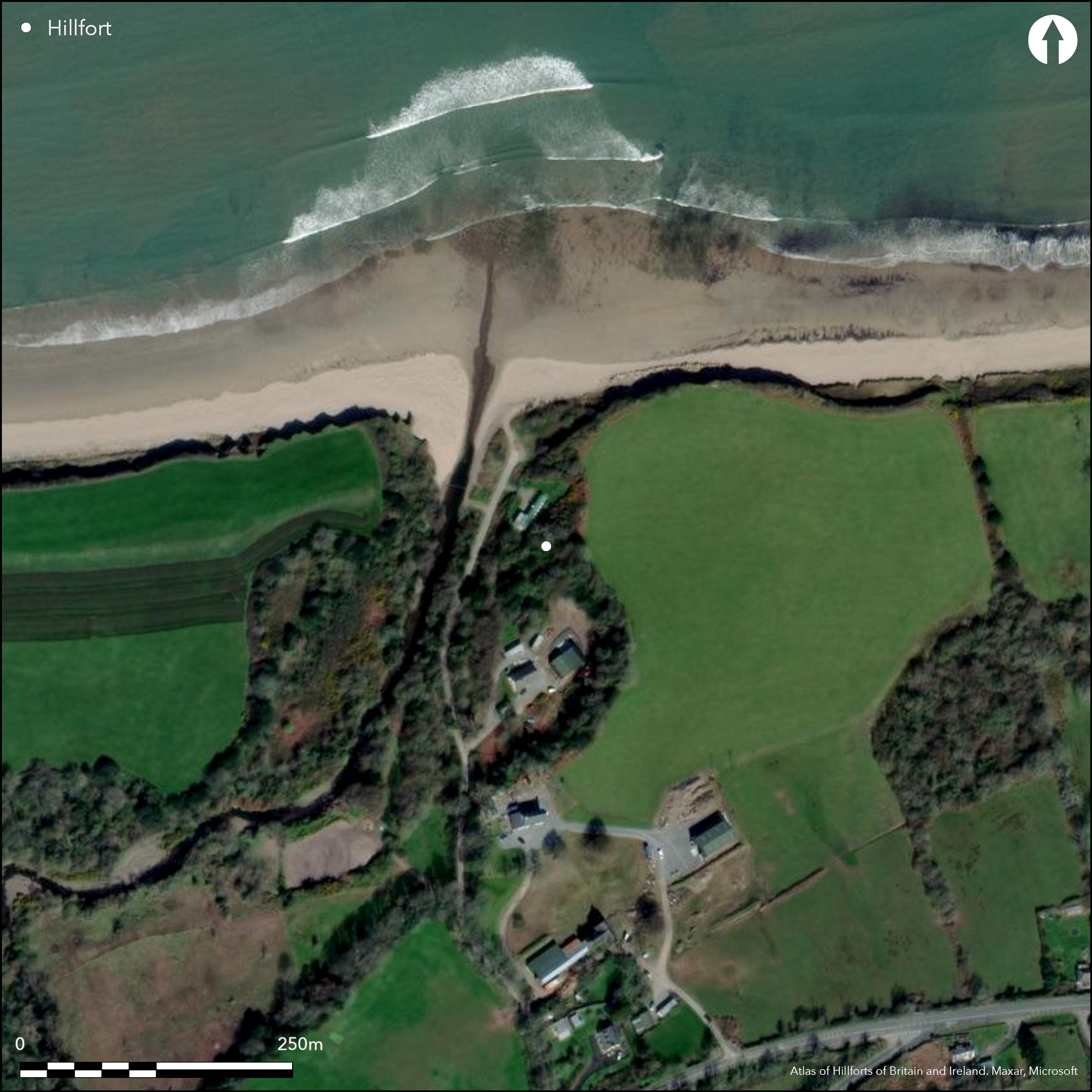
Satellite Imagery
Satellite Imagery
HER: Archaeological Survey of Ireland SMR Database KE037-015 (None)
NMR: KE 037 (None)
SM: None
NGR: None
X: 470106 Y: 610215 (IRENET95)
This possible coastal promontory is located at the mouth of the Finglass River, c. 11km W of Tralee town, Co. Kerry. It is bounded to the NW and S by cliffs up to 7m high. It is situated on an overgrown, triangular headland that projects into the river valley below at an altitude of 7m OD. The site is recorded on the first edition six-inch OS map (1841). It measures 29m NW-SE by 28.3m NE-SW and is enclosed by a curving bank 4m wide by 1.4m high internally and 2m externally (Cuppage 1986, 95). Outside the bank are faint trances of a possible ditch 0.15m deep. An 8m wide gap between the S end and the cliff edge is interpreted as a possible entrance to the fort (O'Sullivan and Sheehan 1996, 95). A drystone wall in a bad state of repair skirts around the edge of the promontory and is interpreted as a more recent addition to the site (ibid., 95). An Seabhac mentions a possible souterrain leading from the interior to the adjacent field (1939, 294), however no such feature is visible today. The interior of the site is inaccessible due to vegetation.
Citizen Science: ✗
Reliability of Data: Confirmed
Reliability of Interpretation: Confirmed
X: -1102226 Y: 6841519 (EPSG: 3857)
Longitude: -9.90146447082563 Latitude: 52.228344848846206 (EPSG:4326)
Country: Republic of Ireland
Current County or Unitary Authority: Kerry
Historic County: Kerry
Current Parish/Community/Council/Townland: Knockglass More
While the site is extant, it is inaccessible due to vegetation.
| Extant | ✓ |
| Cropmark | ✗ |
| Likely Destroyed | ✗ |
The interior of the promontory is heavily overgrown
| Woodland | ✓ |
| Commercial Forestry Plantation | ✗ |
| Parkland | ✗ |
| Pasture (Grazing) | ✗ |
| Arable | ✗ |
| Scrub/Bracken | ✓ |
| Bare Outcrop | ✗ |
| Heather/Moorland | ✗ |
| Heath | ✗ |
| Built-up | ✗ |
| Coastal Grassland | ✗ |
| Other | ✗ |
This coastal promontory is located on the estuary of the Finglass River c. 11km W of Tralee town, Co. Kerry. It is bounded to the E and W by cliffs up to 15m high. It is situated on an overgrown, triangular headland that projects into the river valley below at an altitude of 7m OD. It measures 29m N-S by 28.3m E-W and is defended by a curving bank 4m wide and 1.4m high internally.
| Contour Fort | ✗ |
| Partial Contour Fort | ✗ |
| Promontory Fort | ✓ |
| Hillslope Fort | ✗ |
| Level Terrain Fort | ✗ |
| Marsh Fort | ✗ |
| Multiple Enclosure Fort | ✗ |
| Hilltop | ✗ |
| Coastal Promontory | ✓ |
| Inland Promontory | ✗ |
| Valley Bottom | ✗ |
| Knoll/Hillock/Outcrop | ✗ |
| Ridge | ✗ |
| Cliff/Plateau-edge/Scarp | ✗ |
| Hillslope | ✗ |
| Lowland | ✗ |
| Spur | ✗ |
Dominant Topographic Feature: The site is overlooked to the SE
| North | ✗ |
| Northeast | ✗ |
| East | ✗ |
| Southeast | ✗ |
| South | ✗ |
| Southwest | ✗ |
| West | ✓ |
| Northwest | ✗ |
| Level | ✗ |
Altitude: 7.0m
N/A
There is no dating available for the site
Reliability: D - None
| Pre 1200BC | ✗ |
| 1200BC - 800BC | ✗ |
| 800BC - 400BC | ✗ |
| 400BC - AD50 | ✗ |
| AD50 - AD400 | ✗ |
| AD400 - AD 800 | ✗ |
| Post AD800 | ✗ |
| Unknown | ✓ |
| Pre Hillfort: | None |
| Post Hillfort: | Possible later stone wall |
The site is recorded on the first edition six-inch OS map (1841). Visited and surveyed by the Dingle Survey in the mid-1980s (Cuppage 1986, 90).
| 1st Identified Map Depiction (1841): | OS six-inch mapping |
| Earthwork Survey (1986): | Cuppage 1986 |
There are no recorded internal features within the site, but 'An Seabhac' mentions a possible souterrain leading from the interior to the adjacent filed (1939, 294). There is no surface trace of this feature.
River Finglass borders the site to the W
| None | ✓ |
| Spring | ✗ |
| Stream | ✗ |
| Pool | ✗ |
| Flush | ✗ |
| Well | ✗ |
| Other | ✗ |
None
| No Known Features | ✓ |
| Round Stone Structures | ✗ |
| Rectangular Stone Structures | ✗ |
| Curvilinear Platforms | ✗ |
| Other Roundhouse Evidence | ✗ |
| Pits | ✗ |
| Quarry Hollows | ✗ |
| Other | ✗ |
None
| No Known Excavation | ✓ |
| Pits | ✗ |
| Postholes | ✗ |
| Roundhouses | ✗ |
| Rectangular Structures | ✗ |
| Roads/Tracks | ✗ |
| Quarry Hollows | ✗ |
| Other | ✗ |
| Nothing Found | ✗ |
None
| No Known Geophysics | ✓ |
| Pits | ✗ |
| Roundhouses | ✗ |
| Rectangular Structures | ✗ |
| Roads/Tracks | ✗ |
| Quarry Hollows | ✗ |
| Other | ✗ |
| Nothing Found | ✗ |
None
| No Known Finds | ✓ |
| Pottery | ✗ |
| Metal | ✗ |
| Metalworking | ✗ |
| Human Bones | ✗ |
| Animal Bones | ✗ |
| Lithics | ✗ |
| Environmental | ✗ |
| Other | ✗ |
NO APPARENT FEATURES
| APs Not Checked | ✗ |
| None | ✓ |
| Roundhouses | ✗ |
| Rectangular Structures | ✗ |
| Pits | ✗ |
| Postholes | ✗ |
| Roads/Tracks | ✗ |
| Other | ✗ |
An 8m wide gap between the S end of the defences and the cliff edge is interpreted as a possible entrance to the fort (O'Sullivan and Sheehan 1996, 95). It cannot be confirmed without excavation whether this is an original entrance.
| 1: | None |
| 2: | It cannot be confirmed without excavation whether this is an original entrance. |
Guard Chambers: ✗
Chevaux de Frise: ✗
| 1. Simple Gap (East): | None |
Site is defended on the NE by a curving bank 4m wide by 1.4m high internally and 2m externally (Cuppage 1986, 95). Outside the bank are faint trances of a possible ditch 0.15m deep. A drystone wall in a bad state of repair skirting around the edge of the promontory is interpreted as a more recent addition to the site
| Area 1: | 0.07ha. |
| Total: | 0.07ha. |
Total Footprint Area: 0.08ha.
None
| ✗ | None |
| ✗ | None |
| NE Quadrant: | 1 |
| SE Quadrant: | 0 |
| SW Quadrant: | 0 |
| NW Quadrant: | 0 |
| Total: | 1 |
| Partial Univallate | ✓ |
| Univallate | ✗ |
| Partial Bivallate | ✗ |
| Bivallate | ✗ |
| Partial Multivallate | ✗ |
| Multivallate | ✗ |
| Unknown | ✗ |
| Partial Univallate | ✗ |
| Univallate | ✗ |
| Partial Bivallate | ✗ |
| Bivallate | ✗ |
| Partial Multivallate | ✗ |
| Multivallate | ✗ |
None
| None | ✗ |
| Earthen Bank | ✓ |
| Stone Wall | ✗ |
| Rubble | ✗ |
| Wall-walk | ✗ |
| Evidence of Timber | ✗ |
| Vitrification | ✗ |
| Other Burning | ✗ |
| Palisade | ✗ |
| Counter Scarp Bank | ✗ |
| Berm | ✗ |
| Unfinished | ✗ |
| Other | ✗ |
None
| None | ✗ |
| Earthen Bank | ✗ |
| Stone Wall | ✗ |
| Murus Duplex | ✗ |
| Timber-framed | ✗ |
| Timber-laced | ✗ |
| Vitrification | ✗ |
| Other Burning | ✗ |
| Palisade | ✗ |
| Counter Scarp Bank | ✗ |
| Berm | ✗ |
| Unfinished | ✗ |
| No Known Excavation | ✓ |
| Other | ✗ |
| ✗ | None |
| ✓ | Possible external shallow ditch |
Number of Ditches: 1
| ✗ | None |
Cuppage, J. et al. 1986. Archaeological Survey of the Dingle Peninsula. Ballyferriter
O'Sullivan, A and Sheehan, J. 1996. Iveragh Peninsula: An Archaeological Survey of South Kerry. Cork University Press. Cork
Redmond, M. 1995. A survey of the promontory forts of the Kerry peninsulas. Journal of the Kerry Archaeological and Historical Society 28, 5-63
Seabhac, An. 1939. Tr'ocha-C-ad Chorca Dhuibhne. Baile 'tha Cliath.
Atlas of Hillforts:
Wikidata:
This work is licensed under CC BY-SA 4.0

 and should be cited as:
Lock, Gary and Ralston, Ian. 2024. Atlas of Hillforts of Britain and Ireland. Available at: https://hillforts.arch.ox.ac.uk
Document Version 1.1