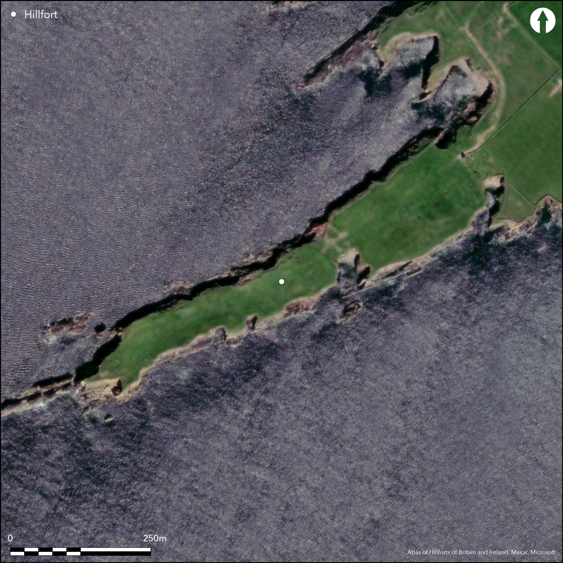
Satellite Imagery
Satellite Imagery
HER: Archaeological Survey of Ireland SMR Database KE042-034001 (None)
NMR: KE 042 (None)
SM: None
NGR: None
X: 431964 Y: 605266 (IRENET95)
Located 3km W of Ballyferriter, Co. Kerry and projecting SW from the mainland, this long headland measures over 500m NE-SW and contains one of the most complex promontory forts in Co. Kerry, with two lines of defences, a tower-house and many possible hut-sites. The site is recorded on the first edition six-inch OS map (1841). The narrow peninsula decreases in width from 100m at the landward end to only a few metres at Doon point and is situated at an altitude of 6m OD. The outer line of defences at the landward side consists of two banks with a large medial ditch spanning the neck between two inlets. A 5.8m wide causeway crosses these near the centre, providing access to the interior. The outer bank is 14m wide, rising c. 1.5m above the external ground level and c. 6m above the base of the ditch, which is c. 5m wide. An earthen field boundary, 0.5m high runs along the top of this bank (Cuppage 1986, 87; O'Sullivan and Sheehan 1996, 87). The inner bank is 4.5m wide and 3m high internally and rises 3.8m above the ditch. A sub-rectangular depression in the N end of this bank is interpreted as a possible guard-chamber; it measures 5m by 4m and is enclosed by a low bank of earth and stone. The ditch decreases in depth to either side of the central causeway and is wider and deeper where it meets the cliff faces. The remains of a medieval tower house known as Ferriters Castle are located on the S side of the causeway at the end of the inner bank. A modern stone wall skirts the N side of the promontory between the two lines of defences and the E end has evidently been cultivated. Nevertheless, low earthen banks NW of the castle appear to define a rectangular house site of possible medieval date. This measures 6.2m by 3.5m, while another is recorded a short distance to the SW measuring 3.5m by 8m. A more definite house-site is recorded on the N edge of the promontory measuring 7m by 1.6m and is internally divided. The defences midway along the promontory to the SW are composed of three banks and two intermediate ditches traversed by a causeway 4m wide. The outer bank is 1m high by 4m wide and is incorporated into a field fence. The middle bank lies 4.4m to the W, and is 1.88m high by 8m wide, standing 2.63m above the bottom of the outer ditch. The inner bank is 5m wide and stands 3.42m high above the base of the inner ditch, but only 0.13m above the level of the interior. Some masonry is recorded on the SE cliff below the inner bank. Nine circular hut-sites are recorded within this enclosed area. They vary in size from 2.5m by 3m to 5.6m by 6.5m and appear to be cut into the underlying bedrock and enclosed by low earth and stone banks, one of which is revetted with upright stone slabs (O'Sullivan and Sheehan 1996, 89). Thirteen oval depressions are also recorded along the cliff edges to the N and S. They are generally open to the cliff edge and cut into the sloping ground on the opposite side. The peninsula is currently under pasture.
Citizen Science: ✗
Reliability of Data: Confirmed
Reliability of Interpretation: Confirmed
X: -1164053 Y: 6831574 (EPSG: 3857)
Longitude: -10.456862168564072 Latitude: 52.17359088819298 (EPSG:4326)
Country: Republic of Ireland
Current County or Unitary Authority: Kerry
Historic County: Kerry
Current Parish/Community/Council/Townland: Ballyoughteragh South
None
| Extant | ✓ |
| Cropmark | ✗ |
| Likely Destroyed | ✗ |
None
| Woodland | ✗ |
| Commercial Forestry Plantation | ✗ |
| Parkland | ✗ |
| Pasture (Grazing) | ✓ |
| Arable | ✗ |
| Scrub/Bracken | ✗ |
| Bare Outcrop | ✗ |
| Heather/Moorland | ✗ |
| Heath | ✗ |
| Built-up | ✗ |
| Coastal Grassland | ✗ |
| Other | ✗ |
This coastal promontory is a long, narrow landmass that projects SW from Ferriters Cove for approximatley 500m at an altitude of 6m OD. It gradually decreases in width from a maximum of 100m at the landward end to only a few metres at Doon Point to the W. It is defended by two sets of defences, one at the E end and the other midway along the promontory.
| Contour Fort | ✗ |
| Partial Contour Fort | ✗ |
| Promontory Fort | ✓ |
| Hillslope Fort | ✗ |
| Level Terrain Fort | ✗ |
| Marsh Fort | ✗ |
| Multiple Enclosure Fort | ✓ |
| Hilltop | ✗ |
| Coastal Promontory | ✓ |
| Inland Promontory | ✗ |
| Valley Bottom | ✗ |
| Knoll/Hillock/Outcrop | ✗ |
| Ridge | ✗ |
| Cliff/Plateau-edge/Scarp | ✗ |
| Hillslope | ✗ |
| Lowland | ✗ |
| Spur | ✗ |
Dominant Topographic Feature: Site is overlooked to the NW
| North | ✗ |
| Northeast | ✗ |
| East | ✗ |
| Southeast | ✗ |
| South | ✗ |
| Southwest | ✗ |
| West | ✗ |
| Northwest | ✗ |
| Level | ✓ |
Altitude: 6.0m
N/A
There is no dating available for the site.
Reliability: D - None
| Pre 1200BC | ✗ |
| 1200BC - 800BC | ✗ |
| 800BC - 400BC | ✗ |
| 400BC - AD50 | ✗ |
| AD50 - AD400 | ✗ |
| AD400 - AD 800 | ✗ |
| Post AD800 | ✗ |
| Unknown | ✓ |
| Pre Hillfort: | None |
| Post Hillfort: | A Medieval castle and a number of possible contemporary buildings are recorded to the E on the landward side of the promontory. |
The site is recorded on the first edition six-inch OS map (1841). Visited and surveyed by Thomas Westropp in 1910 who recorded defences and internal hut-sites. Site later surveyed by the Dingle Survey (Cuppage 1986, 90)
| 1st Identified Map Depiction (1841): | OS six-inch mapping |
| 1st Identified Written Reference (1910): | Westropp |
| Earthwork Survey (1986): | Dingle Survey (Cuppage) |
Six hut-sites are recorded within the E, outer, enclosure. They are chiefly rectangular and are probably related to the medieval castle also located in this area. Nine circular hut-sites are recorded within the enclosed area to the W of the western set of ramparts. They vary in size from 2.5m by 3m to 5.6m by 6.5m and appear to be cut into the underlying bedrock and enclosed by low earth and stone banks, one of which is revetted with upright stone slabs (O'Sullivan and Sheehan 1996, 89). Thirteen oval depressions are also recorded along the cliff edges to the N and S. They are generally open to the cliff edge and cut into the sloping ground on the opposite side
A circular depression recorded with the E interior is recorded as a possible well (Cuppage 1986, 87-89).
| None | ✗ |
| Spring | ✓ |
| Stream | ✗ |
| Pool | ✗ |
| Flush | ✗ |
| Well | ✗ |
| Other | ✗ |
None
| No Known Features | ✗ |
| Round Stone Structures | ✓ |
| Rectangular Stone Structures | ✓ |
| Curvilinear Platforms | ✓ |
| Other Roundhouse Evidence | ✗ |
| Pits | ✗ |
| Quarry Hollows | ✗ |
| Other | ✗ |
None
| No Known Excavation | ✓ |
| Pits | ✗ |
| Postholes | ✗ |
| Roundhouses | ✗ |
| Rectangular Structures | ✗ |
| Roads/Tracks | ✗ |
| Quarry Hollows | ✗ |
| Other | ✗ |
| Nothing Found | ✗ |
None
| No Known Geophysics | ✓ |
| Pits | ✗ |
| Roundhouses | ✗ |
| Rectangular Structures | ✗ |
| Roads/Tracks | ✗ |
| Quarry Hollows | ✗ |
| Other | ✗ |
| Nothing Found | ✗ |
None
| No Known Finds | ✓ |
| Pottery | ✗ |
| Metal | ✗ |
| Metalworking | ✗ |
| Human Bones | ✗ |
| Animal Bones | ✗ |
| Lithics | ✗ |
| Environmental | ✗ |
| Other | ✗ |
None
| APs Not Checked | ✗ |
| None | ✗ |
| Roundhouses | ✓ |
| Rectangular Structures | ✓ |
| Pits | ✗ |
| Postholes | ✗ |
| Roads/Tracks | ✗ |
| Other | ✗ |
Two separate entrances are recorded through both sets of defences.
| 2: | Entrances recorded through the two sets of seperate defences at the site. |
| 2: | None |
Guard Chambers: ✗
Chevaux de Frise: ✗
| 1. Simple Gap (North east): | A 5.8m wide causeway crosses these defences near the centre. |
| 1. Simple Gap (North east): | A 4m wide causeway crosses these defences near the centre. |
The outer line of defences at the landward side consist of two banks with a large medial ditch spanning the neck between two inlets. The outer bank is 14m wide, rising c. 1.5m from the external ground level and c. 6m above the base of the ditch which is c. 5m wide. An earthen field boundary, 0.5m high runs along the top of this bank. The inner bank is 4.5m wide and 3m high internally and rises 3.8m above the bottom of the ditch. A sub-rectangular depression in the N end of this bank is interpreted as a possible guard-chamber. It measures 5m by 4m and is enclosed by a low bank of earth and stone. The defences midway along the promontory are composed of three banks and two ditches traversed by a causeway 4m wide. The outer bank is 1m high by 4m wide and is incorporated into a field fence. The middle bank is 4.4m to the W, 1.88m high and 8m wide, falling 2.63m to the base of the intervening ditch. The inner bank is 3.42m high above the base of the inner ditch and 0.13m high above the interior and 5m wide. Some masonry is recorded on the S cliff below the inner bank.
| Area 1: | 1.31ha. |
| Area 2: | 2.6ha. |
| Total: | 2.6ha. |
Total Footprint Area: 2.9ha.
None
| ✗ | Enclosed area to the E measures approximately 1.26ha while enclosed area to the W measures 1.31ha. |
| ✗ | None |
| NE Quadrant: | 5 |
| SE Quadrant: | 0 |
| SW Quadrant: | 0 |
| NW Quadrant: | 0 |
| Total: | 5 |
| Partial Univallate | ✗ |
| Univallate | ✗ |
| Partial Bivallate | ✗ |
| Bivallate | ✗ |
| Partial Multivallate | ✓ |
| Multivallate | ✗ |
| Unknown | ✗ |
| Partial Univallate | ✗ |
| Univallate | ✗ |
| Partial Bivallate | ✓ |
| Bivallate | ✗ |
| Partial Multivallate | ✗ |
| Multivallate | ✗ |
None
| None | ✗ |
| Earthen Bank | ✓ |
| Stone Wall | ✗ |
| Rubble | ✗ |
| Wall-walk | ✗ |
| Evidence of Timber | ✗ |
| Vitrification | ✗ |
| Other Burning | ✗ |
| Palisade | ✗ |
| Counter Scarp Bank | ✗ |
| Berm | ✗ |
| Unfinished | ✗ |
| Other | ✗ |
None
| None | ✗ |
| Earthen Bank | ✗ |
| Stone Wall | ✗ |
| Murus Duplex | ✗ |
| Timber-framed | ✗ |
| Timber-laced | ✗ |
| Vitrification | ✗ |
| Other Burning | ✗ |
| Palisade | ✗ |
| Counter Scarp Bank | ✗ |
| Berm | ✗ |
| Unfinished | ✗ |
| No Known Excavation | ✓ |
| Other | ✗ |
| ✗ | None |
| ✓ | 2 ditches in the inner set midway along the promontory and one in the outer set of defences |
Number of Ditches: 3
| ✗ | None |
Cuppage, J. et al. 1986. Archaeological Survey of the Dingle Peninsula. Ballyferriter
O'Sullivan, A and Sheehan, J. 1996. Iveragh Peninsula: An Archaeological Survey of South Kerry. Cork University Press. Cork
Redmond, M. 1995. A survey of the promontory forts of the Kerry peninsulas. Journal of the Kerry Archaeological and Historical Society 28, 5-63.
Westropp, T.J. 1910. Promontory forts and similar structures of County Kerry. Journal of the Royal Society of Antiquaries of Ireland 40, 179-213, 265-196
Atlas of Hillforts:
Wikidata:
This work is licensed under CC BY-SA 4.0

 and should be cited as:
Lock, Gary and Ralston, Ian. 2024. Atlas of Hillforts of Britain and Ireland. Available at: https://hillforts.arch.ox.ac.uk
Document Version 1.1