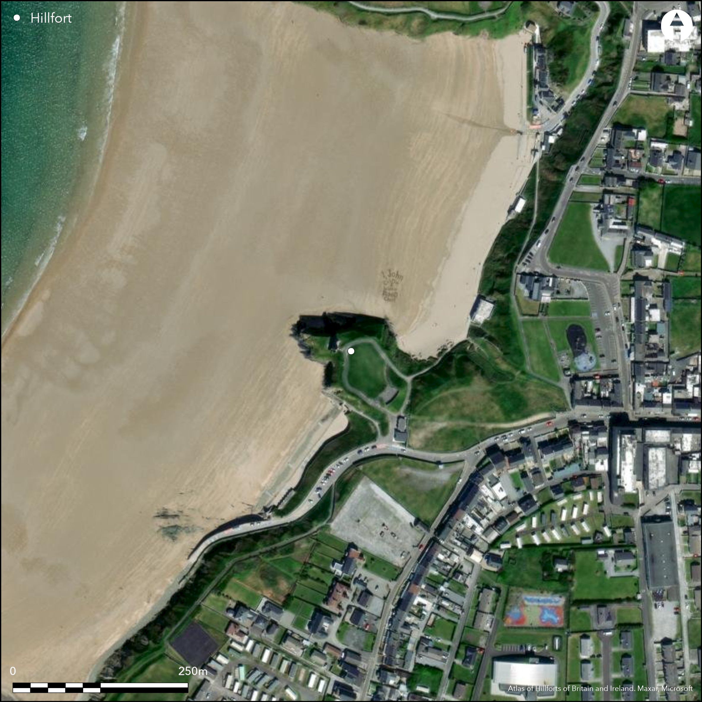
Satellite Imagery
Satellite Imagery
HER: Archaeological Survey of Ireland SMR Database KE004-031001 (None)
NMR: KE 004 (None)
SM: None
NGR: None
X: 486144 Y: 641389 (IRENET95)
This coastal promontory is located at White Strand, projecting W into Ballybunion Bay at an altitude of 7m OD. Ballybunion Castle and its related buildings and garden features occupy the W end of the headland and the site is recorded as Ballybunion Castle on the first edition OS six-inch map (1841), while the possible early defences appear on the second edition six-inch OS map (1914). A modern path runs through the original ditch of the earlier fort. The garden wall of the now demolished Castle Hotel crossed the remains of the outer defences. The ditch is over 6m wide while the inner bank is 7.2m thick and between 1.8m and 2.4m high, rising just a few feet above the interior, which is known as the ÇCastle Green'. Dunne notes that a shale polished stone axe was found in the area of the ditch in the recent past (2003, 160). The interior is roughly oval in shape and the NW end is traversed by another ditch 10.8m from the castle (Toal 1995). Test excavations were undertaken in advance of a proposed development at the site in 2001 (Dunne 2003, 160). Five linked trenches were opened by mechanical track machine and cleaned by hand. All trenches were excavated down to natural. Trenches 3, 4 and 5 were comprised entirely of an undifferentiated sandy fill to the base at an average depth of 1m. No stratigraphy, artefacts or deposits were noted or recorded in these trenches. A possible stone feature recorded at the intersection of Trenches 1 and 2 was modern, inserted to reinforce the edge of the site against erosion (Dunne 2003, 160).
Citizen Science: ✗
Reliability of Data: Confirmed
Reliability of Interpretation: Confirmed
X: -1077282 Y: 6893232 (EPSG: 3857)
Longitude: -9.677385809288085 Latitude: 52.511978003899486 (EPSG:4326)
Country: Republic of Ireland
Current County or Unitary Authority: Kerry
Historic County: Kerry
Current Parish/Community/Council/Townland: Ballybunion
None
| Extant | ✓ |
| Cropmark | ✗ |
| Likely Destroyed | ✓ |
None
| Woodland | ✗ |
| Commercial Forestry Plantation | ✗ |
| Parkland | ✓ |
| Pasture (Grazing) | ✗ |
| Arable | ✗ |
| Scrub/Bracken | ✗ |
| Bare Outcrop | ✗ |
| Heather/Moorland | ✗ |
| Heath | ✗ |
| Built-up | ✗ |
| Coastal Grassland | ✗ |
| Other | ✗ |
This possible coastal promontory fort is located at White Strand, projecting W into Ballybunion Bay, Co. Kerry at an altitude of 7m OD. Ballybunion Castle and its related buildings and garden features occupy the W end of the headland.
| Contour Fort | ✗ |
| Partial Contour Fort | ✗ |
| Promontory Fort | ✓ |
| Hillslope Fort | ✗ |
| Level Terrain Fort | ✗ |
| Marsh Fort | ✗ |
| Multiple Enclosure Fort | ✗ |
| Hilltop | ✗ |
| Coastal Promontory | ✓ |
| Inland Promontory | ✗ |
| Valley Bottom | ✗ |
| Knoll/Hillock/Outcrop | ✗ |
| Ridge | ✗ |
| Cliff/Plateau-edge/Scarp | ✗ |
| Hillslope | ✗ |
| Lowland | ✗ |
| Spur | ✗ |
Dominant Topographic Feature: NW-facing promontory
| North | ✗ |
| Northeast | ✗ |
| East | ✗ |
| Southeast | ✗ |
| South | ✗ |
| Southwest | ✗ |
| West | ✗ |
| Northwest | ✗ |
| Level | ✓ |
Altitude: 7.0m
N/A
There is no dating available for the site
Reliability: D - None
| Pre 1200BC | ✗ |
| 1200BC - 800BC | ✗ |
| 800BC - 400BC | ✗ |
| 400BC - AD50 | ✗ |
| AD50 - AD400 | ✗ |
| AD400 - AD 800 | ✗ |
| Post AD800 | ✗ |
| Unknown | ✓ |
| Pre Hillfort: | Neolithic stone axe found in excavations |
| Post Hillfort: | Ballybunion Castle and its related buildings and garden features occupy the W extent of the headland |
The site is recorded as Ballybunion Castle on the first edition OS six-inch map (1841) and possible early defences are marked on the second edition six-inch OS map (1914). Visited and surveyed by the North Dingle Survey in the mid-1990s (Toal 1995, 79, 81). Test excavations were undertaken in advance of a proposed development in 2001 (Dunne 2003, 160). Nothing of archaeological significance was recovered.
| 1st Identified Map Depiction (1841): | OS six-inch mapping |
| 1st Identified Written Reference (1914): | OS six-inch mapping |
| Earthwork Survey (1995): | North Dingle Survey (Toal) |
| Excavation (2001): | Laurence Dunne test excavations |
Ballybunion Castle and its related buildings and garden features occupy the W end of the headland. A modern path runs through the original ditch of the earlier fort.
None
| None | ✓ |
| Spring | ✗ |
| Stream | ✗ |
| Pool | ✗ |
| Flush | ✗ |
| Well | ✗ |
| Other | ✗ |
Medieval castle remains
| No Known Features | ✗ |
| Round Stone Structures | ✗ |
| Rectangular Stone Structures | ✓ |
| Curvilinear Platforms | ✓ |
| Other Roundhouse Evidence | ✗ |
| Pits | ✗ |
| Quarry Hollows | ✗ |
| Other | ✗ |
None
| No Known Excavation | ✗ |
| Pits | ✗ |
| Postholes | ✗ |
| Roundhouses | ✗ |
| Rectangular Structures | ✗ |
| Roads/Tracks | ✗ |
| Quarry Hollows | ✗ |
| Other | ✗ |
| Nothing Found | ✓ |
None
| No Known Geophysics | ✓ |
| Pits | ✗ |
| Roundhouses | ✗ |
| Rectangular Structures | ✗ |
| Roads/Tracks | ✗ |
| Quarry Hollows | ✗ |
| Other | ✗ |
| Nothing Found | ✗ |
A shale polished stone axe was recovered in the vicinty of the ditch (Dunne 2003).
| No Known Finds | ✗ |
| Pottery | ✗ |
| Metal | ✗ |
| Metalworking | ✗ |
| Human Bones | ✗ |
| Animal Bones | ✗ |
| Lithics | ✓ |
| Environmental | ✗ |
| Other | ✗ |
Medieval castle
| APs Not Checked | ✗ |
| None | ✗ |
| Roundhouses | ✗ |
| Rectangular Structures | ✓ |
| Pits | ✗ |
| Postholes | ✗ |
| Roads/Tracks | ✗ |
| Other | ✗ |
There is no indication of any breaks through the defences however the 25-inch OS map notes that access to the site is gained through a path leading into the site from the SE.
| 0: | None |
| 2: | None |
Guard Chambers: ✗
Chevaux de Frise: ✗
The garden wall of the now demolished Castle Hotel crossed the outer defences. The ditch was over 6m wide while the inner bank is 7.2m thick and between 1.8m and 2.4m high above the bottom of the ditch, rising just a few feet over the «Castle Green. A modern path runs through the original ditch of the earlier fort. The interior is roughly oval shaped and the NW end is traversed by another ditch 48m from the inner bank and 10.8m from the castle (Toal 1995).
| Area 1: | 0.32ha. |
| Total: | 0.32ha. |
Total Footprint Area: 0.58ha.
None
| ✗ | None |
| ✗ | None |
| NE Quadrant: | 0 |
| SE Quadrant: | 1 |
| SW Quadrant: | 0 |
| NW Quadrant: | 0 |
| Total: | 1 |
| Partial Univallate | ✓ |
| Univallate | ✗ |
| Partial Bivallate | ✗ |
| Bivallate | ✗ |
| Partial Multivallate | ✗ |
| Multivallate | ✗ |
| Unknown | ✗ |
| Partial Univallate | ✗ |
| Univallate | ✗ |
| Partial Bivallate | ✗ |
| Bivallate | ✗ |
| Partial Multivallate | ✗ |
| Multivallate | ✗ |
None
| None | ✗ |
| Earthen Bank | ✓ |
| Stone Wall | ✗ |
| Rubble | ✗ |
| Wall-walk | ✗ |
| Evidence of Timber | ✗ |
| Vitrification | ✗ |
| Other Burning | ✗ |
| Palisade | ✗ |
| Counter Scarp Bank | ✗ |
| Berm | ✗ |
| Unfinished | ✗ |
| Other | ✗ |
None
| None | ✓ |
| Earthen Bank | ✗ |
| Stone Wall | ✗ |
| Murus Duplex | ✗ |
| Timber-framed | ✗ |
| Timber-laced | ✗ |
| Vitrification | ✗ |
| Other Burning | ✗ |
| Palisade | ✗ |
| Counter Scarp Bank | ✗ |
| Berm | ✗ |
| Unfinished | ✗ |
| No Known Excavation | ✗ |
| Other | ✗ |
| ✗ | None |
| ✓ | None |
Number of Ditches: 2
| ✗ | None |
Toal, C. 1995. North Kerry Archaeological Survey. Dingle
Dunne, N. 2003. Ballybunion. In E. Bennett (ed.) Excavations 2001, 160. Wordwell, Bray.
Atlas of Hillforts:
Wikidata:
This work is licensed under CC BY-SA 4.0

 and should be cited as:
Lock, Gary and Ralston, Ian. 2024. Atlas of Hillforts of Britain and Ireland. Available at: https://hillforts.arch.ox.ac.uk
Document Version 1.1