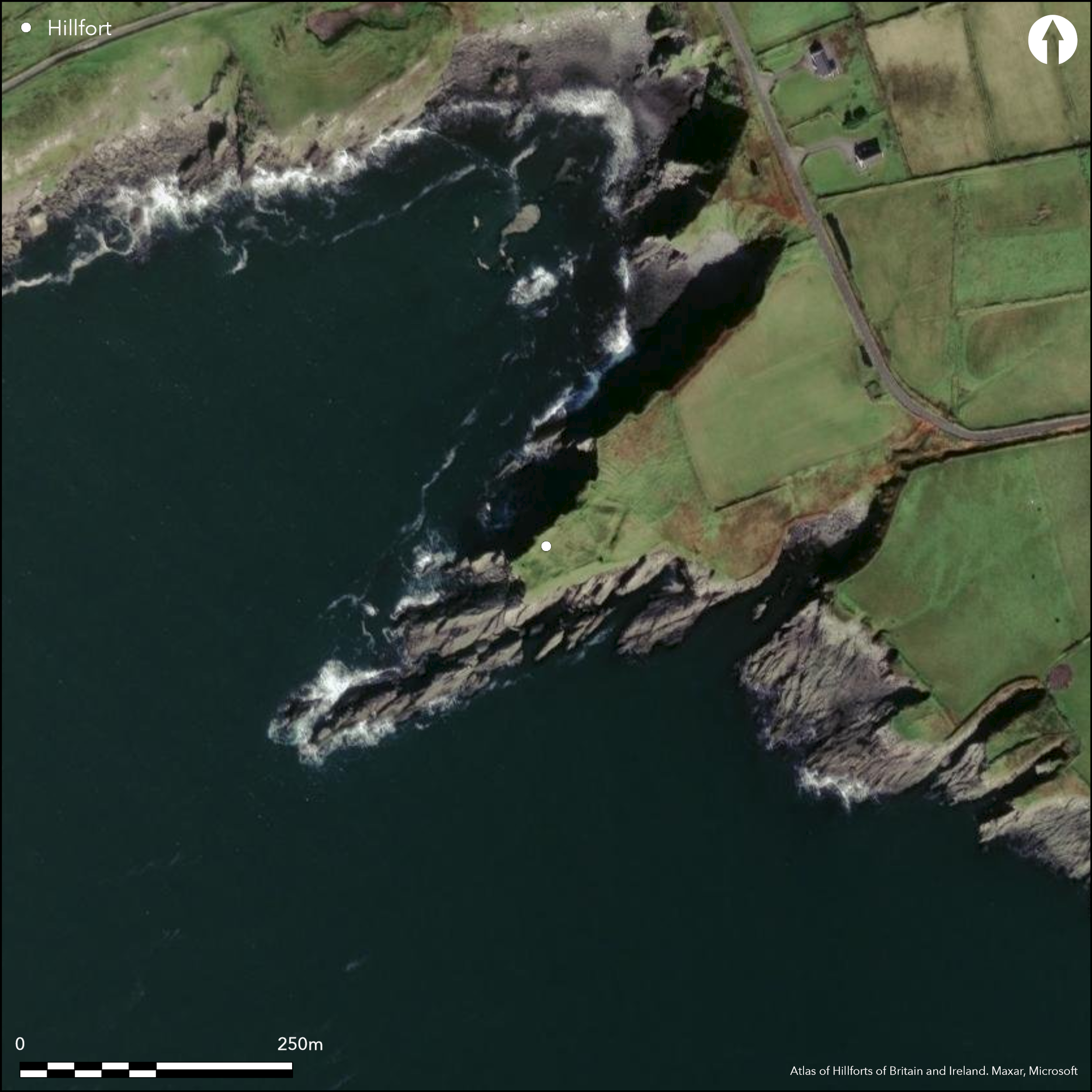
Satellite Imagery
Satellite Imagery
HER: Archaeological Survey of Ireland SMR Database KE087-034001 (None)
NMR: KE 087 (None)
SM: None
NGR: None
X: 435435 Y: 573571 (IRENET95)
This coastal promontory is located close to the SW end of Valencia Island at an altitude of 5m OD. It is situated between Foilhomurrum Bay and the narrowest point of Portmagee Sound. The site is depicted as a Cromwellian fort on the first edition six-inch map (1841), with a triangular bastion facing onto the landward approach from the NE. Sited on a steep sided headland, Westropp records the Cromwellian defences as the remains of a 'late outwork, a nearly equilateral triangle of fosses 9 feet wide, 6 feet deep and each about 63 feet long' (1912, 306), but suggested that these rest on the base of an older ditch '6 feet to 10 feet deep, 12 feet wide below, and cut deeply into the rock' (ibid.). This he attributed to an earlier promontory fort (KE087-034001-), though no definite traces of such a fort can be distinguished from remains of a blockhouse located at the forward tip of a cliff promontory, known as Sculgaphort, and the ditches of the large ravelin on the NE (O'Sullivan and Sheehan 1996).
Citizen Science: ✗
Reliability of Data: Unconfirmed
Reliability of Interpretation: Unconfirmed
X: -1156712 Y: 6780257 (EPSG: 3857)
Longitude: -10.390921445626056 Latitude: 51.889982102828476 (EPSG:4326)
Country: Republic of Ireland
Current County or Unitary Authority: Kerry
Historic County: Kerry
Current Parish/Community/Council/Townland: Coarhabeg
None
| Extant | ✗ |
| Cropmark | ✗ |
| Likely Destroyed | ✓ |
None
| Woodland | ✗ |
| Commercial Forestry Plantation | ✗ |
| Parkland | ✗ |
| Pasture (Grazing) | ✓ |
| Arable | ✗ |
| Scrub/Bracken | ✗ |
| Bare Outcrop | ✗ |
| Heather/Moorland | ✗ |
| Heath | ✗ |
| Built-up | ✗ |
| Coastal Grassland | ✗ |
| Other | ✗ |
between Foilhomurrum Bay and the narrowest point of Portmagee Sound _ the S entrance into Valencia Harbour. Situated on a steep sided headland of c. 5m OD, Westropp records the possibility of earlier defences under the post-medieval fortifications.
| Contour Fort | ✗ |
| Partial Contour Fort | ✗ |
| Promontory Fort | ✓ |
| Hillslope Fort | ✗ |
| Level Terrain Fort | ✗ |
| Marsh Fort | ✗ |
| Multiple Enclosure Fort | ✗ |
| Hilltop | ✗ |
| Coastal Promontory | ✓ |
| Inland Promontory | ✗ |
| Valley Bottom | ✗ |
| Knoll/Hillock/Outcrop | ✗ |
| Ridge | ✗ |
| Cliff/Plateau-edge/Scarp | ✗ |
| Hillslope | ✗ |
| Lowland | ✗ |
| Spur | ✗ |
Dominant Topographic Feature: SW-facing promontory
| North | ✗ |
| Northeast | ✗ |
| East | ✗ |
| Southeast | ✗ |
| South | ✗ |
| Southwest | ✓ |
| West | ✗ |
| Northwest | ✗ |
| Level | ✗ |
Altitude: 5.0m
N/A
There is no dating available for the site
Reliability: D - None
| Pre 1200BC | ✗ |
| 1200BC - 800BC | ✗ |
| 800BC - 400BC | ✗ |
| 400BC - AD50 | ✗ |
| AD50 - AD400 | ✗ |
| AD400 - AD 800 | ✗ |
| Post AD800 | ✗ |
| Unknown | ✓ |
| Pre Hillfort: | None |
| Post Hillfort: | Medieval fortifications |
The site is depicted as a Cromwellian fort on the first edition six-inch map (1841). Visited and surveyed by Westropp in 1912, who records earlier defences and later fortification. Noted by the Iveragh Archaeological Survey in the 1990s.
| 1st Identified Map Depiction (1841): | OS six-inch mapping |
| 1st Identified Written Reference (1912): | Westropp |
| Earthwork Survey (1996): | O'Sullivan and Sheehan 1996 |
Poorly preserved remains of a Cromwellian blockhouse is located at the forward tip of a cliff promontory, known as Sculgaphort, and is defended by a ditch and a large ravelin at its landward side
None
| None | ✓ |
| Spring | ✗ |
| Stream | ✗ |
| Pool | ✗ |
| Flush | ✗ |
| Well | ✗ |
| Other | ✗ |
Cromwellian Fort
| No Known Features | ✗ |
| Round Stone Structures | ✗ |
| Rectangular Stone Structures | ✗ |
| Curvilinear Platforms | ✗ |
| Other Roundhouse Evidence | ✗ |
| Pits | ✗ |
| Quarry Hollows | ✗ |
| Other | ✓ |
None
| No Known Excavation | ✓ |
| Pits | ✗ |
| Postholes | ✗ |
| Roundhouses | ✗ |
| Rectangular Structures | ✗ |
| Roads/Tracks | ✗ |
| Quarry Hollows | ✗ |
| Other | ✗ |
| Nothing Found | ✗ |
None
| No Known Geophysics | ✓ |
| Pits | ✗ |
| Roundhouses | ✗ |
| Rectangular Structures | ✗ |
| Roads/Tracks | ✗ |
| Quarry Hollows | ✗ |
| Other | ✗ |
| Nothing Found | ✗ |
None
| No Known Finds | ✓ |
| Pottery | ✗ |
| Metal | ✗ |
| Metalworking | ✗ |
| Human Bones | ✗ |
| Animal Bones | ✗ |
| Lithics | ✗ |
| Environmental | ✗ |
| Other | ✗ |
Cromwellian Fort
| APs Not Checked | ✗ |
| None | ✗ |
| Roundhouses | ✗ |
| Rectangular Structures | ✗ |
| Pits | ✗ |
| Postholes | ✗ |
| Roads/Tracks | ✗ |
| Other | ✓ |
Westropp records a 'gangeway' crossing the the remains of the earlier ditch (1912, 306). No other information available.
| 0: | None |
| 2: | None |
Guard Chambers: ✗
Chevaux de Frise: ✗
| 1. Simple Gap (North east): | None |
Westropp records the remains of the Cromwellian fort as a 'late outwork, a nearly equilateral triangle of fosses 9 feet wide, 6 feet deep and each about 63 feet long' (1912, 306). He suggested that these defences rest on the base of an older ditch '6 feet to 10 feet deep, 12 feet wide below, and cut deeply into the rock' (ibid.)
| Area 1: | 0.21ha. |
| Total: | 0.21ha. |
Total Footprint Area: 0.25ha.
None
| ✗ | None |
| ✗ | None |
| NE Quadrant: | 0 |
| SE Quadrant: | 0 |
| SW Quadrant: | 0 |
| NW Quadrant: | 0 |
| Total: | 0 |
| Partial Univallate | ✗ |
| Univallate | ✗ |
| Partial Bivallate | ✗ |
| Bivallate | ✗ |
| Partial Multivallate | ✗ |
| Multivallate | ✗ |
| Unknown | ✓ |
| Partial Univallate | ✗ |
| Univallate | ✗ |
| Partial Bivallate | ✗ |
| Bivallate | ✗ |
| Partial Multivallate | ✗ |
| Multivallate | ✗ |
None
| None | ✓ |
| Earthen Bank | ✗ |
| Stone Wall | ✗ |
| Rubble | ✗ |
| Wall-walk | ✗ |
| Evidence of Timber | ✗ |
| Vitrification | ✗ |
| Other Burning | ✗ |
| Palisade | ✗ |
| Counter Scarp Bank | ✗ |
| Berm | ✗ |
| Unfinished | ✗ |
| Other | ✗ |
None
| None | ✗ |
| Earthen Bank | ✗ |
| Stone Wall | ✗ |
| Murus Duplex | ✗ |
| Timber-framed | ✗ |
| Timber-laced | ✗ |
| Vitrification | ✗ |
| Other Burning | ✗ |
| Palisade | ✗ |
| Counter Scarp Bank | ✗ |
| Berm | ✗ |
| Unfinished | ✗ |
| No Known Excavation | ✓ |
| Other | ✗ |
| ✗ | None |
| ✓ | None |
Number of Ditches: 1
| ✗ | None |
O'Sullivan, A and Sheehan, J. 1996. Iveragh Peninsula: An Archaeological Survey of South Kerry. Cork University Press. Cork
Westropp, T. J. 1912. Notes on the promontory forts and similar structures of County Kerry. Part V- Iveragh (Valentia to St. Finans Bay). Proceedings of the Royal Society of Antiquaries of Ireland 47, 305.
Atlas of Hillforts:
Wikidata:
This work is licensed under CC BY-SA 4.0

 and should be cited as:
Lock, Gary and Ralston, Ian. 2024. Atlas of Hillforts of Britain and Ireland. Available at: https://hillforts.arch.ox.ac.uk
Document Version 1.1