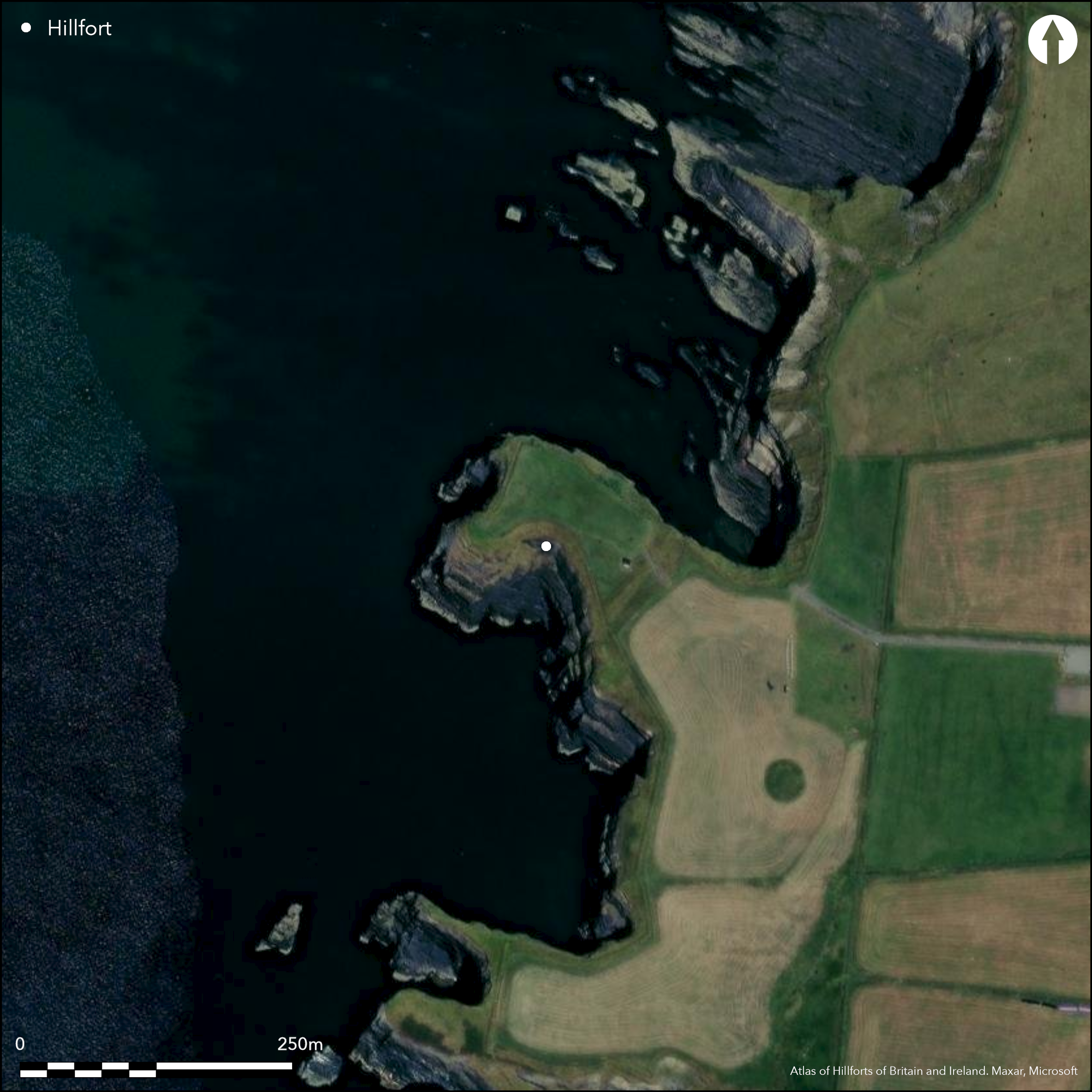
Satellite Imagery
Satellite Imagery
HER: Archaeological Survey of Ireland SMR Database KE004-003 (None)
NMR: KE 004 (None)
SM: None
NGR: None
X: 486602 Y: 644140 (IRENET95)
This coastal promontory is situated c. 2.7km N of Ballybunion, Co. Kerry, projecting NW from the mainland at an altitude of 6m OD. The site is recorded on the first edition six-inch OS map (1841) and second editions (1914-15) as 'Tonalassa'. Measuring 102m NW-SE by about 55m NE-SW, the headland is enclosed to the SE by a steep, stone-faced earthen bank and an external ditch drawn in a shallow arc across the neck over a distance of 65m. The ditch is traversed by a causeway c. 2m wide at the NE end of the defences, which Westropp notes was a 'late gap and gageway (1910, 22). The ditch measures on average 5m in width, and has a maximum depth below the surrounding land of 1.5m. According to Westropp there was an outer bank that has been completely levelled. Material from this bank has filled some of the ditch (1910, 22). The inner bank rises to a maximum height of 5m above the bottom of the ditch and has width of 7m to 8m at its base. The internal height of the bank above the interior measures c. 2m. Apart from a WW1 lookout tower, there are no recorded internal features within the interior, which has been enclosed and cultivated as a field.
Citizen Science: ✗
Reliability of Data: Confirmed
Reliability of Interpretation: Confirmed
X: -1076635 Y: 6897772 (EPSG: 3857)
Longitude: -9.671579658043644 Latitude: 52.5367893749398 (EPSG:4326)
Country: Republic of Ireland
Current County or Unitary Authority: Kerry
Historic County: Kerry
Current Parish/Community/Council/Townland: Bromore West
None
| Extant | ✓ |
| Cropmark | ✗ |
| Likely Destroyed | ✗ |
None
| Woodland | ✗ |
| Commercial Forestry Plantation | ✗ |
| Parkland | ✗ |
| Pasture (Grazing) | ✓ |
| Arable | ✗ |
| Scrub/Bracken | ✗ |
| Bare Outcrop | ✗ |
| Heather/Moorland | ✗ |
| Heath | ✗ |
| Built-up | ✗ |
| Coastal Grassland | ✗ |
| Other | ✗ |
This coastal promontory is situated c. 2.7km N of Ballybunion, Co. Kerry, projecting NW from the mainland at an altitude of 6m OD. Measuring 102m NW-SE and 56m N-S the headland is defended to the SE by a steep, stone-faced earthen bank and an external ditch.
| Contour Fort | ✗ |
| Partial Contour Fort | ✗ |
| Promontory Fort | ✓ |
| Hillslope Fort | ✗ |
| Level Terrain Fort | ✗ |
| Marsh Fort | ✗ |
| Multiple Enclosure Fort | ✗ |
| Hilltop | ✗ |
| Coastal Promontory | ✓ |
| Inland Promontory | ✗ |
| Valley Bottom | ✗ |
| Knoll/Hillock/Outcrop | ✗ |
| Ridge | ✗ |
| Cliff/Plateau-edge/Scarp | ✗ |
| Hillslope | ✗ |
| Lowland | ✗ |
| Spur | ✗ |
Dominant Topographic Feature: NW-facing promontory
| North | ✗ |
| Northeast | ✗ |
| East | ✗ |
| Southeast | ✗ |
| South | ✗ |
| Southwest | ✗ |
| West | ✗ |
| Northwest | ✓ |
| Level | ✗ |
Altitude: 6.0m
N/A
There is no dating available for the site
Reliability: D - None
| Pre 1200BC | ✗ |
| 1200BC - 800BC | ✗ |
| 800BC - 400BC | ✗ |
| 400BC - AD50 | ✗ |
| AD50 - AD400 | ✗ |
| AD400 - AD 800 | ✗ |
| Post AD800 | ✗ |
| Unknown | ✓ |
| Pre Hillfort: | None |
| Post Hillfort: | WWI lookout bunker |
The site is recorded on the first edition six-inch OS map (1841) and second editions (1914-15) as 'Tonalassa'.Visited and surveyed by Westropp in the early twentieth century who recorded the defences . Visited by the North Dingle Survey in the mid-1990s (Toal 1995).
| 1st Identified Map Depiction (1841): | OS six-inch mapping |
| 1st Identified Written Reference (1910): | Westropp |
| Earthwork Survey (1995): | North Kerry Survey |
A WWI lookout tower is recorded within the interior of the site.
None
| None | ✓ |
| Spring | ✗ |
| Stream | ✗ |
| Pool | ✗ |
| Flush | ✗ |
| Well | ✗ |
| Other | ✗ |
WW1 lookout tower
| No Known Features | ✗ |
| Round Stone Structures | ✗ |
| Rectangular Stone Structures | ✗ |
| Curvilinear Platforms | ✗ |
| Other Roundhouse Evidence | ✗ |
| Pits | ✗ |
| Quarry Hollows | ✗ |
| Other | ✓ |
None
| No Known Excavation | ✓ |
| Pits | ✗ |
| Postholes | ✗ |
| Roundhouses | ✗ |
| Rectangular Structures | ✗ |
| Roads/Tracks | ✗ |
| Quarry Hollows | ✗ |
| Other | ✗ |
| Nothing Found | ✗ |
None
| No Known Geophysics | ✓ |
| Pits | ✗ |
| Roundhouses | ✗ |
| Rectangular Structures | ✗ |
| Roads/Tracks | ✗ |
| Quarry Hollows | ✗ |
| Other | ✗ |
| Nothing Found | ✗ |
None
| No Known Finds | ✓ |
| Pottery | ✗ |
| Metal | ✗ |
| Metalworking | ✗ |
| Human Bones | ✗ |
| Animal Bones | ✗ |
| Lithics | ✗ |
| Environmental | ✗ |
| Other | ✗ |
NO APPARENT FEATURES
| APs Not Checked | ✓ |
| None | ✗ |
| Roundhouses | ✗ |
| Rectangular Structures | ✗ |
| Pits | ✗ |
| Postholes | ✗ |
| Roads/Tracks | ✗ |
| Other | ✗ |
The ditch is traversed by a causeway c. 2m wide at the NE end of the defences which Westropp notes was a 'late gap and gageway (1910, 22).
| 1: | It cannot be confirmed whether this is an original feature |
| 2: | None |
Guard Chambers: ✗
Chevaux de Frise: ✗
| 1. Simple Gap (South east): | None |
The headland is defended to the SE by a steep, stone-faced earthen bank and an external ditch. The ditch measures 65m long and on average 5m in width, and has a maximum depth below the surrounding land of 1.5m. According to Westropp there was evidence of an outer bank that has been completely levelled being; material from this bank has filled some of the ditch (1910, 22). The inner bank rises to a maximum height of 5m above the bottom of the ditch, and 2m above the level of the interior, and has a width of 7m to 8m at its base.
| Area 1: | 0.56ha. |
| Total: | 0.56ha. |
Total Footprint Area: 0.72ha.
None
| ✗ | None |
| ✗ | None |
| NE Quadrant: | 0 |
| SE Quadrant: | 1 |
| SW Quadrant: | 0 |
| NW Quadrant: | 0 |
| Total: | 1 |
| Partial Univallate | ✓ |
| Univallate | ✗ |
| Partial Bivallate | ✗ |
| Bivallate | ✗ |
| Partial Multivallate | ✗ |
| Multivallate | ✗ |
| Unknown | ✗ |
| Partial Univallate | ✗ |
| Univallate | ✗ |
| Partial Bivallate | ✗ |
| Bivallate | ✗ |
| Partial Multivallate | ✗ |
| Multivallate | ✗ |
Stone faced earthen bank
| None | ✗ |
| Earthen Bank | ✓ |
| Stone Wall | ✓ |
| Rubble | ✗ |
| Wall-walk | ✗ |
| Evidence of Timber | ✗ |
| Vitrification | ✗ |
| Other Burning | ✗ |
| Palisade | ✗ |
| Counter Scarp Bank | ✗ |
| Berm | ✗ |
| Unfinished | ✗ |
| Other | ✗ |
None
| None | ✗ |
| Earthen Bank | ✗ |
| Stone Wall | ✗ |
| Murus Duplex | ✗ |
| Timber-framed | ✗ |
| Timber-laced | ✗ |
| Vitrification | ✗ |
| Other Burning | ✗ |
| Palisade | ✗ |
| Counter Scarp Bank | ✗ |
| Berm | ✗ |
| Unfinished | ✗ |
| No Known Excavation | ✓ |
| Other | ✗ |
| ✗ | None |
| ✓ | None |
Number of Ditches: 1
| ✗ | None |
Toal, C. 1995. North Kerry Archaeological Survey. Dingle
Westropp, T.J. 1910. Promontory forts and similar structures of County Kerry. Journal of the Royal Society of Antiquaries of Ireland 40, 179-213, 265-196
Atlas of Hillforts:
Wikidata:
This work is licensed under CC BY-SA 4.0

 and should be cited as:
Lock, Gary and Ralston, Ian. 2024. Atlas of Hillforts of Britain and Ireland. Available at: https://hillforts.arch.ox.ac.uk
Document Version 1.1