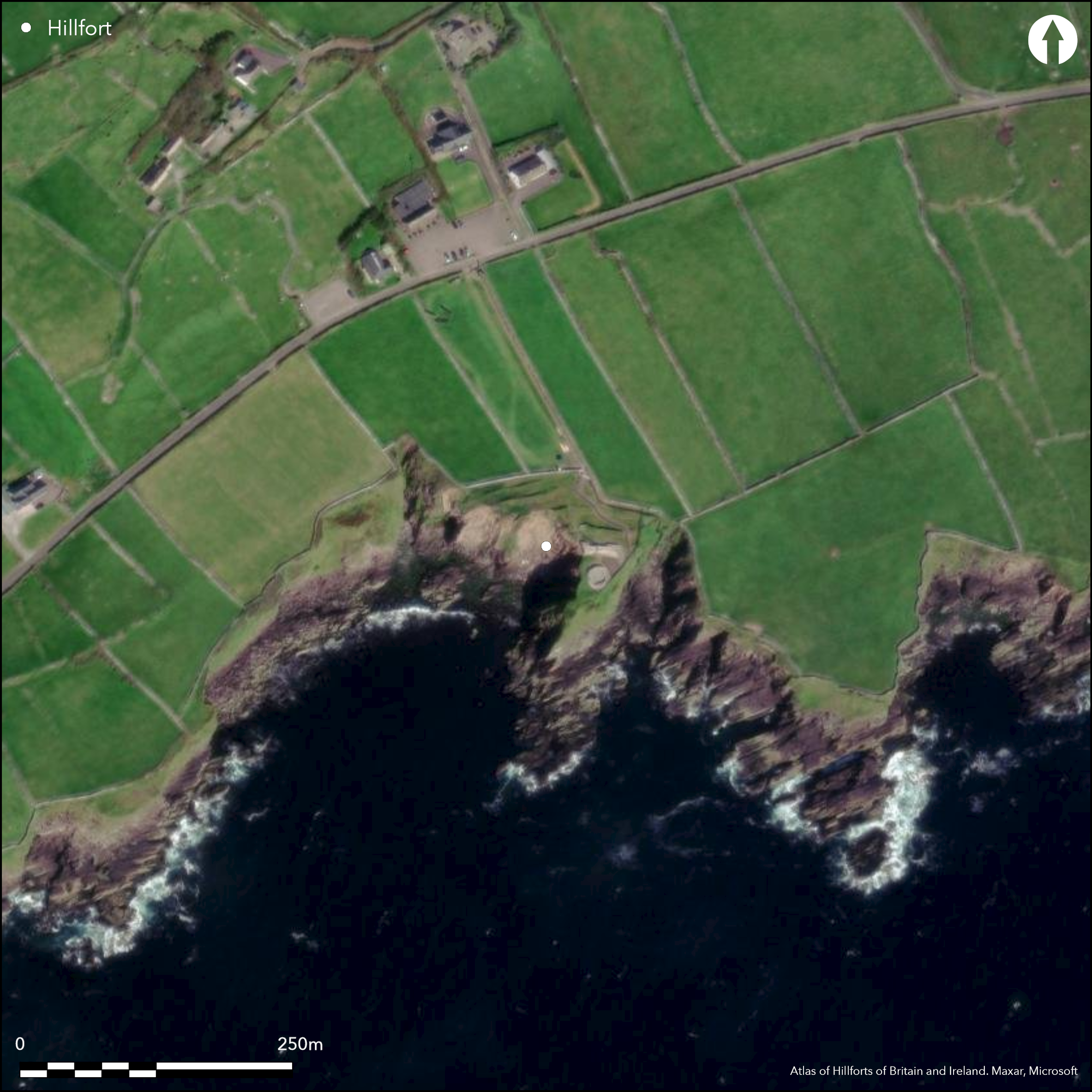
Satellite Imagery
Satellite Imagery
HER: Archaeological Survey of Ireland SMR Database KE052-270001 (None)
NMR: KE 052 (None)
SM: None
NGR: None
X: 434986 Y: 597363 (IRENET95)
This small coastal promontory fort, known as 'D–n Beg', is located on a sheer cliff projecting S into Dingle Bay at the base of Mount Eagle at an altitude of 20m OD. It is c. 4.5km SW of Ventry town, Co. Kerry. To the W of the fort and along its E edge are several small streams which run off the foothills of Mount Eagle into Dingle Bay. The site is recorded on the first edition six-inch OS map (1841) and second editions (1914-15) as 'Dunbeg'. It can be described as a roughly triangular promontory of c. 0.52ha, defended on the N by an inner drystone wall with four outer lines of banks, five ditches; the wall has a complex entrance flanked by two guard chambers. A souterrain extends under the causeway from this entrance and in the interior is a single clochaun or dry-stone building. After the fort was acquired by the Office of Public Works (OPW), the defences were re-built and modified in places. It has suffered extensive erosion since it was first recorded in the early 19th century by John Windele (1848, 472-77). As a result, in 1977, the OPW initiated an excavation which was conducted a few years later (Barry 1981, 295-329). The overall plan of the defences is somewhat confused by the later alterations. Excavation revealed that the banks were made up of re-deposited yellow brown clay with a mix of small stones. These banks stood to a height of up to lm above the old ground level and were up to 3m wide (Barry 1991, 303). Tentative traces of a palisade trench were found on the N facing crest of the inner bank and possibly along the N face of the next bank, while there were also indications of possible stone facing on the N sides of both banks (ibid., 303). Portions of the 2 outer banks lie outside a boundary wall constructed in the 1890's, and their line is now barely perceptible. The ditches range in depth from 0.98m to 1.55m below the old ground surface and are 5.6m to 12m wide. Most of the fill of these ditches was made up of a yellowy grey clay deposit that was up to 0.9m deep. Ditch 1 however had a different profile from the others as it was deeper and had more steeply sloping sides. The fill was also different, being made up of an extensive stone infill up. A sample of wood charcoal was taken from the base of this ditch for radiocarbon dating, which produced a date of 691-1018 cal AD. This would strongly indicate that this ditch was in use in the eighth and ninth centuries AD. A number of breaks recorded in the earthen banks are a result of the removal of N/S field fences that once crossed the defences. A possible original entrance is recorded centrally with a causeway 1.2m wide. Upright slabs lined the edges of this and a few of these still survive towards the S end. Over half of the original interior has probably been destroyed by erosion on the W The inner stone rampart is up to 6.35m thick and 3.08m high, extending across the promontory for 29m. This is only about half the length recorded in 1856 by Du Noyer (1858, 2) as much of the W half has fallen into the sea. The rampart seems, however, to have been preceded by an earlier shallow ditch or trench which ran for a known length of 19m. Barry suggests that a layer of charcoal along the whole length of the ditch, and immediately under the topsoil, could be explained by the burning and consequent collapse of a wattle fence. A radiocarbon date of 797-539 BC was obtained from a sample of this charcoal layer. The early plans and descriptions of the site indicate a straight wall running from cliff edge to cliff edge (Du Noyer 1858; Pitt-Rivers c. 1865). At present there is a curved terminal to the E end of the rampart and a similar terminal existed at the W end prior to its erosion. There appears to have been 2 construction phases. Phase 1 is represented by the inner half of the wall; this measures 4.8m in width and 2.76m in height and has 3 terraces along its inner face. The lintelled entrance passage is 2m wide and 2.3m high with slightly corbelled side walls. Two small chambers are incorporated within the thickness of the wall on either side of this. At a later stage the exterior capstone of the passage cracked and pillars were inserted along the E side wall to give support. The passage was also extended outwards, but was reduced in width and height to .92m and 1.24m respectively. At the same time the adjacent ditch was deepened. The upcast soil was piled against the outer face of the rampart to form the core of a strengthening wall measuring 1.75 to 2.25m wide and 1.9m high. A stone flagged pathway leads from the entrance in the rampart to a clochaun in the interior of the fort. The clochaun, circular in plan outside and rectangular inside, has an internal diameter of 7.5m and is a maximum of 2.3m high. The lintelled doorway faces NW. Two major phases of occupation were recorded during the excavation of the clochaun. The 1st phase was centered on a small hearth close to its S wall. Clusters of stake holes to N and S probably indicate the presence of tripods for supporting pots or skins over the fire. The 2nd occupation layer lay 0.18 to 0.3m above the 1st and was concentrated on 2 hearths in the centre of the clochaun. The bones of sheep, pig, deer, birds and fish were recovered. Several post-holes and numerous stake holes were also recorded. Although the walls corbel inwards, Barry considered the span too great to have supported a corbelled roof and suggests that the structure may never have been roofed. Instead lean-to shelters may have been erected in the NW, SE and SW corners with 2 of the sides supported by the clochaun walls and the other sides by wooden posts. Dates of 1050±65 BP (UB-2218, 784-1156 cal AD) and 960±100 BP (UB-2217, 891-1263 cal AD) from the occupation layers in the clochaun, suggest it was inhabited in the 10th or 11th centuries AD. In late January 2014, as a result of serious storm damage, a substantial portion of the fort along the western cliff edge fell into the sea.
Citizen Science: ✗
Reliability of Data: Confirmed
Reliability of Interpretation: Confirmed
X: -1158712 Y: 6818866 (EPSG: 3857)
Longitude: -10.408886065170659 Latitude: 52.10352710522261 (EPSG:4326)
Country: Republic of Ireland
Current County or Unitary Authority: Kerry
Historic County: Kerry
Current Parish/Community/Council/Townland: Fahan/F_n
In late January 2014, as a result of serious storm damage, a substantial portion of the fort along the western cliff edge fell into the sea.
| Extant | ✓ |
| Cropmark | ✗ |
| Likely Destroyed | ✓ |
None
| Woodland | ✗ |
| Commercial Forestry Plantation | ✗ |
| Parkland | ✗ |
| Pasture (Grazing) | ✓ |
| Arable | ✗ |
| Scrub/Bracken | ✗ |
| Bare Outcrop | ✗ |
| Heather/Moorland | ✗ |
| Heath | ✗ |
| Built-up | ✗ |
| Coastal Grassland | ✗ |
| Other | ✗ |
This small coastal promontory, known as 'D–n Beg' is located on a sheer cliff projecting S into Dingle Bay at the base of Mount Eagle at an altitude of 20m OD.
| Contour Fort | ✗ |
| Partial Contour Fort | ✗ |
| Promontory Fort | ✓ |
| Hillslope Fort | ✗ |
| Level Terrain Fort | ✗ |
| Marsh Fort | ✗ |
| Multiple Enclosure Fort | ✗ |
| Hilltop | ✗ |
| Coastal Promontory | ✓ |
| Inland Promontory | ✗ |
| Valley Bottom | ✗ |
| Knoll/Hillock/Outcrop | ✗ |
| Ridge | ✗ |
| Cliff/Plateau-edge/Scarp | ✗ |
| Hillslope | ✗ |
| Lowland | ✗ |
| Spur | ✗ |
Dominant Topographic Feature: S-facing promontory
| North | ✗ |
| Northeast | ✗ |
| East | ✗ |
| Southeast | ✗ |
| South | ✓ |
| Southwest | ✗ |
| West | ✗ |
| Northwest | ✗ |
| Level | ✗ |
Altitude: 20.0m
N/A
The absence of dateable finds creates difficulties in proposing a chronology for the site. A radiocarbon date 1150±75 BP (UB-2215, 691-1018 cal AD) from the base of the inner ditch, suggests it was in existence in the 8th or 9th centuries AD. Dates of 1050±65 BP (UB-2218, 784-1156 cal AD) and 960±100 BP (UB-2217, 891-1263 cal AD) from the occupation layers in the clochaun, suggest it was inhabited in the 10th or 11th centuries AD. However, a late Bronze Age date of 797-539 BC (2530±35 BP, UB-2216) was also obtained from charcoal in the ditch that preceded the drystone wall.
Reliability: B - Medium
| Pre 1200BC | ✗ |
| 1200BC - 800BC | ✓ |
| 800BC - 400BC | ✗ |
| 400BC - AD50 | ✗ |
| AD50 - AD400 | ✗ |
| AD400 - AD 800 | ✗ |
| Post AD800 | ✓ |
| Unknown | ✗ |
| Pre Hillfort: | None |
| Post Hillfort: | None |
| C14: | All dates are calibrated to 2 sigma and dated from charcoal. |
The site is recorded on the first edition six-inch OS map (1841) and second editions (1914-15) as 'Dunbeg'. The first written survey of the fort is to be found in the writings of the Cork antiquary, John Windele, who visited it in 1848. Windele reported that the stone rampart 'extends in a straight line 'and that in his day the entrance-way was in its centre with the two' creeps' on either side. In 1856 George Du Noyer visited the site and two years later he published a report on it which included a plan of the fort showing, again, that the rampart wall cut off the end of the promontory in a straight line with chambers on either side of the entrance-way. In 1892, the fort was acquired by the Commissioners of Public Works from a Mr Charles Drummond as a National Monument (No. 177). As a result of this, a programme of reconstruction work was undertaken. As well as all the reconstruction work, the dry-stone walls of three leaseholders' fields that crossed the fort in a north south direction were also removed. A boundary wall, gate and stile were constructed around the perimeter of the fort to protect it and to mark out the area of the National Monument. From June to September 1977 the site was partially excavated by Terry Barry. The areas chosen for investigation included cutting sections through the landward earthen defences, and almost the entirety of the main stone rampart and the cloch_n (Barry 1981). Site later surveyed by the Kerry Archaeological Survey (Cuppage 1986).
| 1st Identified Map Depiction (1841): | OS six-inch mapping |
| 1st Identified Written Reference (1848): | Windele |
| Earthwork Survey (1856): | George Du Noyer |
| Earthwork Survey (1910): | Westropp |
| Excavation (1977): | T.B Barry |
| Earthwork Survey (1986): | Kerry Archaeological Survey |
Two guard chambers are recorded flanking the lintelled entrance through the stone rampart. They measure 2.3 x 1.4m x almost 2m high (E chamber) and 2.4 x 1m x 1.2m high (W chamber). A stone flagged pathway leads from the entrance in the rampart to a clochaun in the interior of the fort. The clochaun, circular in plan outside and rectangular inside, is 7.5m across the interior and is a maximum of 2.3m high. The lintelled doorway faces NW. Two major phases of occupation were recorded during the excavation of the clochaun. In addition, a drystone-built souterrain extends for 16.5m from within the entrance passage to some 2m S of the inner face of bank 2. For most of its length it measures 1m wide and 1m high.
None
| None | ✓ |
| Spring | ✗ |
| Stream | ✗ |
| Pool | ✗ |
| Flush | ✗ |
| Well | ✗ |
| Other | ✗ |
Souterrain
| No Known Features | ✗ |
| Round Stone Structures | ✗ |
| Rectangular Stone Structures | ✓ |
| Curvilinear Platforms | ✗ |
| Other Roundhouse Evidence | ✗ |
| Pits | ✗ |
| Quarry Hollows | ✗ |
| Other | ✓ |
None
| No Known Excavation | ✗ |
| Pits | ✗ |
| Postholes | ✗ |
| Roundhouses | ✗ |
| Rectangular Structures | ✓ |
| Roads/Tracks | ✗ |
| Quarry Hollows | ✗ |
| Other | ✗ |
| Nothing Found | ✗ |
None
| No Known Geophysics | ✓ |
| Pits | ✗ |
| Roundhouses | ✗ |
| Rectangular Structures | ✗ |
| Roads/Tracks | ✗ |
| Quarry Hollows | ✗ |
| Other | ✗ |
| Nothing Found | ✗ |
The finds from the site were: 13 sherds of post-Medieval pottery from the topsoil; three nails (two of iron and one of copper); a brass shirt button; a brass medal of the 'Catholic Total Abstinence League'; a possible fragment of a quern stone; a possible sandstone pestle; two small hone stones; an undecorated spindle whorl; three flint flakes with secondary working; a flint blade from a residual context; and two late 19th century clay pipe bowls. Animal bone was identified as cattle, sheep, pig, goat and fish.
| No Known Finds | ✗ |
| Pottery | ✓ |
| Metal | ✓ |
| Metalworking | ✗ |
| Human Bones | ✗ |
| Animal Bones | ✓ |
| Lithics | ✓ |
| Environmental | ✗ |
| Other | ✗ |
None
| APs Not Checked | ✗ |
| None | ✗ |
| Roundhouses | ✗ |
| Rectangular Structures | ✓ |
| Pits | ✗ |
| Postholes | ✗ |
| Roads/Tracks | ✗ |
| Other | ✗ |
A number of breaks in the earthen banks appear to by modern as a result of the removal of a field fence. The original entrance pierces the earthen banks centrally and is lined with stones, approaching the lintelled passage through the stone rampart. The latter has two associated guard chambers.
| 10: | A number of breaks recorded in the earthen banks are a result of the removal of N/S field fences which once crossed the defences |
| 2: | None |
Guard Chambers: ✓
Chevaux de Frise: ✗
| 1. Simple Gap (North): | A possible original entrance is recorded centrally, serviced by a causeway 1.2m wide. Upright slabs lined the edges of this and a few of these still survive towards the S end |
| 1. Recesses/Guard Chambers (North): | The lintelled entrance passage is 2m wide and 2.3m high with slightly corbelled side walls. Two small chambers are incorporated within the thickness of the wall on either side of this. The passage was also extended outwards, but was reduced in width and height to .92m and 1.24m respectivelyrespectively |
The promontory is defended on the N by an inner drystone wall and four outer lines of banks and five ditches; the inner wall has a complex entrance flanked by two guard chambers. Excavation revealed that the banks were made up of re deposited yellow brown clay with a mix of small stones. These banks stood to a height of up to lm above the old ground level and were up to 3m wide (Barry 1991, 303). Tentative traces of a palisade trench were found on the N facing crest of the inner bank and possibly along the N face of the next bank while there were also indications of possible stone facing on the N sides of both banks (ibid., 303). The ditches range in depth from 0.98m to 1.55m below the old ground surface and are 5.6m to 12m wide. Most of the fill of these ditches was made up of a yellowy grey clay deposit that was up to 0.9m deep. Ditch 1 however had a different profile from the others as it was deeper and had more steeply sloping sides. The inner stone rampart is up to 6.35m thick and 3.08m high, extending across the promontory for 29m. This is only about half the length recorded in 1856 by Du Noyer (1858, 2) as much of the W half has fallen into the sea. The rampart seems, however, to have been preceded by an earlier shallow ditch or trench which ran for a known length of 19m. There appears to have been 2 construction phases. Phase 1 is represented by the inner half of the wall; this measures 4.8m in width and 2.76m in height and has 3 terraces along its inner face. At a later stage the exterior capstone of the entrance passage cracked and pillars were inserted along the E side wall to give support. The passage was also extended outwards.
| Area 1: | 0.1ha. |
| Total: | 0.1ha. |
Total Footprint Area: 0.49ha.
None
| ✗ | In late January 2014, as a result of serious storm damage, a substantial portion of the fort along the internal western cliff edge fell into the sea, reducing the overall enclosed area to no more than 0.05ha. |
| ✗ | None |
| NE Quadrant: | 0 |
| SE Quadrant: | 0 |
| SW Quadrant: | 0 |
| NW Quadrant: | 5 |
| Total: | 5 |
| Partial Univallate | ✗ |
| Univallate | ✗ |
| Partial Bivallate | ✗ |
| Bivallate | ✗ |
| Partial Multivallate | ✓ |
| Multivallate | ✗ |
| Unknown | ✗ |
| Partial Univallate | ✗ |
| Univallate | ✗ |
| Partial Bivallate | ✗ |
| Bivallate | ✗ |
| Partial Multivallate | ✗ |
| Multivallate | ✗ |
Terraced profile of the wall, though a wall-walk as such may not have survived
| None | ✗ |
| Earthen Bank | ✓ |
| Stone Wall | ✓ |
| Rubble | ✗ |
| Wall-walk | ✓ |
| Evidence of Timber | ✗ |
| Vitrification | ✗ |
| Other Burning | ✗ |
| Palisade | ✗ |
| Counter Scarp Bank | ✗ |
| Berm | ✗ |
| Unfinished | ✗ |
| Other | ✗ |
Four earthen banks, one stone rampart, under which is the remains of an earlier shallow ditch with burnt timber fence dating to the Late Bronze Age.
| None | ✗ |
| Earthen Bank | ✓ |
| Stone Wall | ✓ |
| Murus Duplex | ✗ |
| Timber-framed | ✗ |
| Timber-laced | ✗ |
| Vitrification | ✗ |
| Other Burning | ✓ |
| Palisade | ✓ |
| Counter Scarp Bank | ✗ |
| Berm | ✗ |
| Unfinished | ✗ |
| No Known Excavation | ✗ |
| Other | ✗ |
| ✗ | None |
| ✓ | None |
Number of Ditches: 5
| ✗ | None |
Barry, T.B. 1981. Archaeological excavations at Dunbeg Promontory Fort, Co. Kerry, 1977. Proceedings of the Royal Irish Academy 81, 295-329.
Cuppage, J. et al. 1986. Archaeological Survey of the Dingle Peninsula. Ballyferriter
Deane, T.N. 1893. A report on ancient monuments in Co. Kerry. Proceedings of the Royal Irish Academy 19, 100-107.
Du Noyer, G.V. 1858. On the remains of ancient stone-built fortresses and habitations occurring to the west of Dingle, Co. Kerry. Archaeological Journal 40, 1-24.
O'Sullivan, A and Sheehan, J. 1996. Iveragh Peninsula: An Archaeological Survey of South Kerry. Cork University Press. Cork
Redmond, M. 1995. A survey of the promontory forts of the Kerry peninsulas. Journal of the Kerry Archaeological and Historical Society 28, 5-63
Westropp, T.J. 1910. Promontory forts and similar structures of County Kerry. Journal of the Royal Society of Antiquaries of Ireland 40, 179-213, 265-196
Windele, J. (1848) Iar Mumhan, excursions in Kerry. Proceedings of the Royal Irish Academy 11, 472-477.
Atlas of Hillforts:
Wikidata:
This work is licensed under CC BY-SA 4.0

 and should be cited as:
Lock, Gary and Ralston, Ian. 2024. Atlas of Hillforts of Britain and Ireland. Available at: https://hillforts.arch.ox.ac.uk
Document Version 1.1