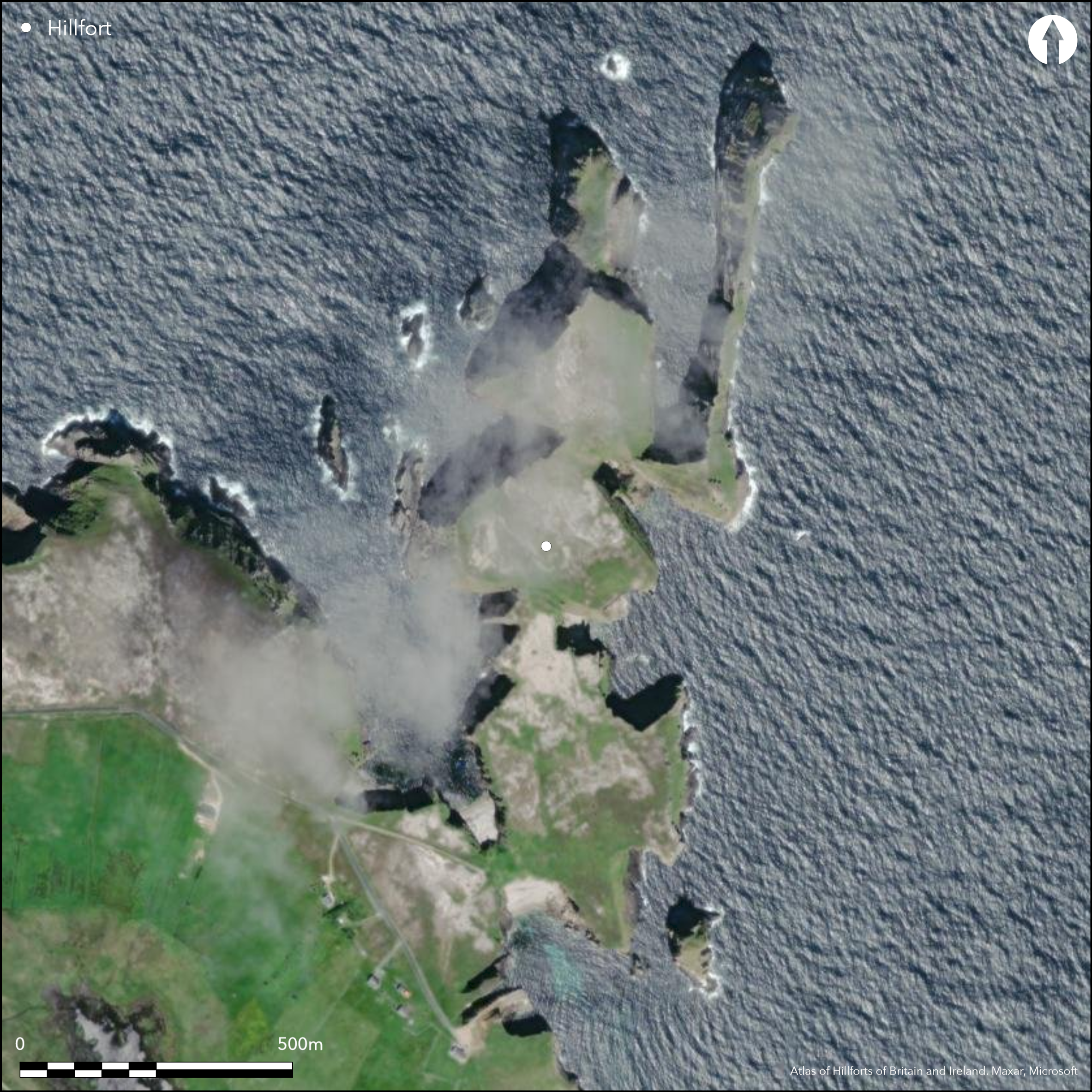
Satellite Imagery
Satellite Imagery
HER: Archaeological Survey of Ireland SMR Database DG006-004001 (None)
NMR: DG 006 (None)
SM: None
NGR: None
X: 587654 Y: 945893 (IRENET95)
This coastal promontory, depicted as 'Balor's Fort' on the first edition OS six-inch map, is situated at the E end of Tory Island about seven miles off the coast of Co. Donegal. Composed of a series of connected, rocky peninsulas projecting N from the mainland, the landmass is the highest part of Tory Island and roughly measures 700m in overall length N-S by between 50m and 220m E-W. These indented peninsulas are enclosed by a series of stone and earthwork elements, within which a number of possible structures and hut-sites are visible, one of which was investigated during the 1940's (Sidebotham 1949, 98-103). The OS 6-inch maps depict the site of a castle overlooking the neck of the peninsula at the S end, recorded by O'Donovan in 1835 as a modern square castle of lime and stone (O'Flanagan 1927, 57). There are no visible remains of this castle and it is not clear what connection if any it had with the southernmost enclosure of the peninsular, comprising a stone wall (Lacey 1983, 226). Drawn in a concave arc above the low neck 40m wide that forms a natural ditch separating the peninsular from the mainland, the remains of this grass-covered stone wall are c. 40m long and 2m wide, and range in height from 0.5m to 1m. Cutting off the whole peninsula, this in effect encloses an area of about 7.9ha on the upper surface. Within this outer part of the peninsula, which extends to about 4ha, the area is subdivided approximately 80m E of the neck. by a bank of earth and stone c. 3m wide and 1m high running for a distance of 105m NW-SE from the cliff edge on the SE side, before petering out on the top of the peninsula. An external ditch associated with the bank on its SW side is c. 2m wide and 0.5m deep and there is a 3m to 4m wide entrance gap 45m from its SE end (Lacey 1983, 226). N of this entrance is a c. 10m square enclosure built up against the bank and formed of grass-grown earth and stone banks, while a further 10m N a band of water-rolled beach stones c. 0.5m to 1m wide runs E. The latter forms one of a series of such features in this area and includes an approximately 8m square enclosure formed by lines of stones. A little further N, set out over a distance of 60m in a line running E and W, the remains of four small, stone-built enclosures or huts can be seen; a possible well lies nearby. To the N the peninsula narrows to another isthmus (c. 40m wide E-W and 60m long N-S) where an impressive series ramparts and ditches have been constructed, referred to as 'Balor's Fort' on the OS 6-inch maps. Four earthen banks and at least three intermediate ditches, and possibly with a fourth outer ditch, rising above each other with the trend of the natural slope to the N. There is some evidence for a possible stone revetment on the inner side of the innermost bank on the N. A causeway cuts across these defences on the W and narrows from 5m wide on the S to 2m on the N or inner end (Lacey 1983, 226). Behind these defences the peninsula widens to c. 220m E-W before constricting to another neck about 100m to the N, and scattered over the S facing slopes in this area are the remains of at least twenty hut-sites, some of which are know on the island as 'Diarmuid and Grania's' Partially protected by the higher ground to the N, they are typically defined by roughly circular depressions within low banks. A rock-cut well is also recorded in this area. Beyond the neck to the N, an arm of land, annotated 'The Anvil' on the second edition OS six-inch map, projects out from the island to a narrow blade-edge, tower of rock, called 'Tormore', which is virtually inaccessible. The S end of this projection consists of a level area of land defined by sheer cliff edges, to which access is barred from the W by a rock-cut ditch c. 1.5m deep, with possible traces of a internal bank along its E lip (Lacey 1983, 227). On the cliff edge within this area, in an extremely exposed position, there are the remains of a sub-circular collapsed stone enclosure c. 10m in diameter with a gap to the SE. .
Citizen Science: ✗
Reliability of Data: Confirmed
Reliability of Interpretation: Confirmed
X: -912176 Y: 7412495 (EPSG: 3857)
Longitude: -8.194216789887777 Latitude: 55.260016857108425 (EPSG:4326)
Country: Republic of Ireland
Current County or Unitary Authority: Donegal (Tory Island)
Historic County: Donegal
Current Parish/Community/Council/Townland: Tory Island
None
| Extant | ✓ |
| Cropmark | ✗ |
| Likely Destroyed | ✗ |
None
| Woodland | ✗ |
| Commercial Forestry Plantation | ✗ |
| Parkland | ✗ |
| Pasture (Grazing) | ✗ |
| Arable | ✗ |
| Scrub/Bracken | ✓ |
| Bare Outcrop | ✗ |
| Heather/Moorland | ✓ |
| Heath | ✗ |
| Built-up | ✗ |
| Coastal Grassland | ✓ |
| Other | ✗ |
This coastal promontory is composed of a series of connected, rocky peninsulas projecting N from the mainland. The landmass is the highest part of Tory Island and roughly measures 700m N-S by 50m to 220m E-W. These indented peninsulas are enclosed by a series of stone and earthwork elements that enclose a number of possible structures and hut-sites
| Contour Fort | ✗ |
| Partial Contour Fort | ✗ |
| Promontory Fort | ✓ |
| Hillslope Fort | ✗ |
| Level Terrain Fort | ✗ |
| Marsh Fort | ✗ |
| Multiple Enclosure Fort | ✓ |
| Hilltop | ✗ |
| Coastal Promontory | ✓ |
| Inland Promontory | ✗ |
| Valley Bottom | ✗ |
| Knoll/Hillock/Outcrop | ✗ |
| Ridge | ✗ |
| Cliff/Plateau-edge/Scarp | ✗ |
| Hillslope | ✗ |
| Lowland | ✗ |
| Spur | ✗ |
Dominant Topographic Feature: N-facing promontory
| North | ✓ |
| Northeast | ✗ |
| East | ✗ |
| Southeast | ✗ |
| South | ✗ |
| Southwest | ✗ |
| West | ✗ |
| Northwest | ✗ |
| Level | ✗ |
Altitude: 16.0m
N/A
A few pieces of flint, including a scraper, and a sharp tooth from some implement were discovered, as well as some broken pieces of pottery during an investigation by Sidebothem in 1949. The recovered artefacts give little indication of the the true age of the promontory enclosure.
Reliability: D - None
| Pre 1200BC | ✗ |
| 1200BC - 800BC | ✗ |
| 800BC - 400BC | ✗ |
| 400BC - AD50 | ✗ |
| AD50 - AD400 | ✗ |
| AD400 - AD 800 | ✗ |
| Post AD800 | ✗ |
| Unknown | ✓ |
| Pre Hillfort: | None |
| Post Hillfort: | Possible Medieval castle |
| Artefactual: | Flint scraper and a sherd of possible early medieval pottery were recovered from an investigation of one of the hut-sites in 1949. |
The S penninsula is depicted as 'The Port Doon' on the second edition OS six-inch map while the enclosed area further N is recorded as 'Balors Fort'. The furthest peninsula is marked as 'Doon Balor'. The OS 6-inch maps record the site of a castle on the peninsula to the S, recorded by O'Donovan in 1835 as a modern square castle of lime and stone (O'Flanagan 1927, 57). Two of the twenty or so hut structures recorded in the middle of the landmass were partially investigated by Sidebothem in 1949 who noted that the walls were constructed of stone and earth and some were internally divided. When the surface stones, sods and soil were removed from a part of the hut floor there appeared a layer of 'black clay, the so-called "blue clay" common as a flooring material in old Irish cottages' (1949, 102). It formed a layer from four to seven inches thick, and where removed was underlain by small stones set evenly. In this layer of clay in the south-east corner of the inner room, main hut, were found small pieces of charcoal, a few pieces of flint, including a scraper, and a sherd of pottery. The site was surveyed during the early 1980s for the compilation of the archaeological inventory of Co. Donegal (Lacy 1983).
| Excavation (1949): | Sidebothem |
| Earthwork Survey (1983): | Brian Lacey (Donegal Archaeological Survey) |
| 1st Identified Map Depiction (None): | OS six-inch mapping |
In the outermost enclosure on the S peninsula there are a c. 10m square enclosure formed of grass-grown earth and stone banks and built up against a bank that subdivides this area. In the vicinity on the N there are several low banks of water-rolled beach stones, including an approximately 8m square enclosure formed by lines of stones. A little further N disposed over a distance of c. 60m from E to W, there are the remains of four small, stone-built enclosures that are probably hut-sites; a possible well is recorded nearby. On the middle of the peninsula, scattered over the S facing slope behind the main set of defences, there are at least twenty hut-sites, comprising roughly circular depressions enclosed by earth and stone banks; they include definite hut circles with an overall maximum dimension of c. 10m. A similar site was partially excavated here (Sidebotham 1949, 98--103). Adjacent to one (E of No. 16) is a rock-cut well. On the E arm of the northernmost part of the peninsula there are the remains of a sub-circular collapsed stone enclosure c. 10m in diameter with a gap to the SE. Lacey suggests that all of the enclosures and hut circles referred to above seem to have been built on the rocky surface of the island either before or at an early stage in the development of the turf (1983, 227).
Two wells are recorded within the interior of two of the connected peninsulas.
| None | ✗ |
| Spring | ✗ |
| Stream | ✗ |
| Pool | ✗ |
| Flush | ✗ |
| Well | ✓ |
| Other | ✗ |
None
| No Known Features | ✗ |
| Round Stone Structures | ✓ |
| Rectangular Stone Structures | ✗ |
| Curvilinear Platforms | ✗ |
| Other Roundhouse Evidence | ✗ |
| Pits | ✗ |
| Quarry Hollows | ✗ |
| Other | ✓ |
None
| No Known Excavation | ✗ |
| Pits | ✗ |
| Postholes | ✗ |
| Roundhouses | ✓ |
| Rectangular Structures | ✗ |
| Roads/Tracks | ✗ |
| Quarry Hollows | ✗ |
| Other | ✗ |
| Nothing Found | ✗ |
None
| No Known Geophysics | ✓ |
| Pits | ✗ |
| Roundhouses | ✗ |
| Rectangular Structures | ✗ |
| Roads/Tracks | ✗ |
| Quarry Hollows | ✗ |
| Other | ✗ |
| Nothing Found | ✗ |
None
| No Known Finds | ✗ |
| Pottery | ✓ |
| Metal | ✗ |
| Metalworking | ✗ |
| Human Bones | ✗ |
| Animal Bones | ✗ |
| Lithics | ✓ |
| Environmental | ✓ |
| Other | ✗ |
None
| APs Not Checked | ✗ |
| None | ✗ |
| Roundhouses | ✓ |
| Rectangular Structures | ✗ |
| Pits | ✗ |
| Postholes | ✗ |
| Roads/Tracks | ✗ |
| Other | ✗ |
No entrance is recorded in the outermost line blocking access to the peninsular from the S, but a causeway pierces the major set of defences midway along the peninsular.
| 2: | The entrance through the bank recorded as the 2nd enclosing element in the outer enclosure is not counted here as an original entrance into the enclosed areas |
| 2: | None |
Guard Chambers: ✗
Chevaux de Frise: ✗
| 1. Simple Gap (South): | A causeway cuts across the major line of defences on the W and narrows from 5m wide on the S to 2m on the N or inner end. |
This coastal promontory, depicted as 'Balor's Fort' on the first edition OS six-inch map, is cut off above the low neck 40m wide that forms a natural ditch separating the peninsula from the mainland by the remains of a grass-covered stone wall c. 40m long and 2m wide, and from 0.5m to 1m in height. Cutting off the whole peninsular, this in effect encloses an area of about 7.9ha on the upper surface. To the N, where the peninsula narrows to another isthmus an impressive series of four ramparts have been constructed, with at least three intermediate ditches, and possibly with a fourth outer ditch. The crests of the ramparts rise progressively above each other with the trend of the natural slope to the N. There is some evidence for a possible stone revetment on the inner side of the innermost bank on the N. Beyond another neck to the N, an arm of land, annotated 'The Anvil' on the second edition OS six-inch map, projects out from the island to a narrow blade-edge, tower of rock, called 'Tormore', which is virtually inaccessible. The S end of this projection consists of a level area of land defined by sheer cliff edges, to which access is barred from the W by a rock-cut ditch c. 1.5m deep, with possible traces of a internal bank along its E lip (Lacey 1983, 227)
| Area 1: | 0.98ha. |
| Area 2: | 3.9ha. |
| Area 3: | 7.9ha. |
| Total: | 7.9ha. |
Total Footprint Area: 10.81ha.
None
| ✗ | Three separate areas on the peninsula are enclosed |
| ✗ | Composed of a series of connected, rocky peninsulas projecting N from the mainland. These indented peninsulas are defended by a series of stone and earthwork elements in different sectors of the headland. The principal defence of four ramparts is identified below |
| NE Quadrant: | 0 |
| SE Quadrant: | 0 |
| SW Quadrant: | 4 |
| NW Quadrant: | 0 |
| Total: | 4 |
| Partial Univallate | ✗ |
| Univallate | ✗ |
| Partial Bivallate | ✗ |
| Bivallate | ✗ |
| Partial Multivallate | ✓ |
| Multivallate | ✗ |
| Unknown | ✗ |
| Partial Univallate | ✓ |
| Univallate | ✗ |
| Partial Bivallate | ✗ |
| Bivallate | ✗ |
| Partial Multivallate | ✗ |
| Multivallate | ✗ |
A stone wall to the S while the rest of the banks were composed of earth and stone with facing noted on some.
| None | ✗ |
| Earthen Bank | ✓ |
| Stone Wall | ✓ |
| Rubble | ✗ |
| Wall-walk | ✗ |
| Evidence of Timber | ✗ |
| Vitrification | ✗ |
| Other Burning | ✗ |
| Palisade | ✗ |
| Counter Scarp Bank | ✗ |
| Berm | ✗ |
| Unfinished | ✗ |
| Other | ✗ |
None
| None | ✗ |
| Earthen Bank | ✗ |
| Stone Wall | ✗ |
| Murus Duplex | ✗ |
| Timber-framed | ✗ |
| Timber-laced | ✗ |
| Vitrification | ✗ |
| Other Burning | ✗ |
| Palisade | ✗ |
| Counter Scarp Bank | ✗ |
| Berm | ✗ |
| Unfinished | ✗ |
| No Known Excavation | ✓ |
| Other | ✗ |
| ✗ | None |
| ✓ | None |
Number of Ditches: 5
| ✗ | None |
Lacey, B. 1983. Archaeological Survey of County Donegal. Lifford
Sidebotham, J.N. 1949. A promontory fort on Tory Island. Ulster Journal of Archaeology 12, 98-103
Atlas of Hillforts:
Wikidata:
This work is licensed under CC BY-SA 4.0

 and should be cited as:
Lock, Gary and Ralston, Ian. 2024. Atlas of Hillforts of Britain and Ireland. Available at: https://hillforts.arch.ox.ac.uk
Document Version 1.1