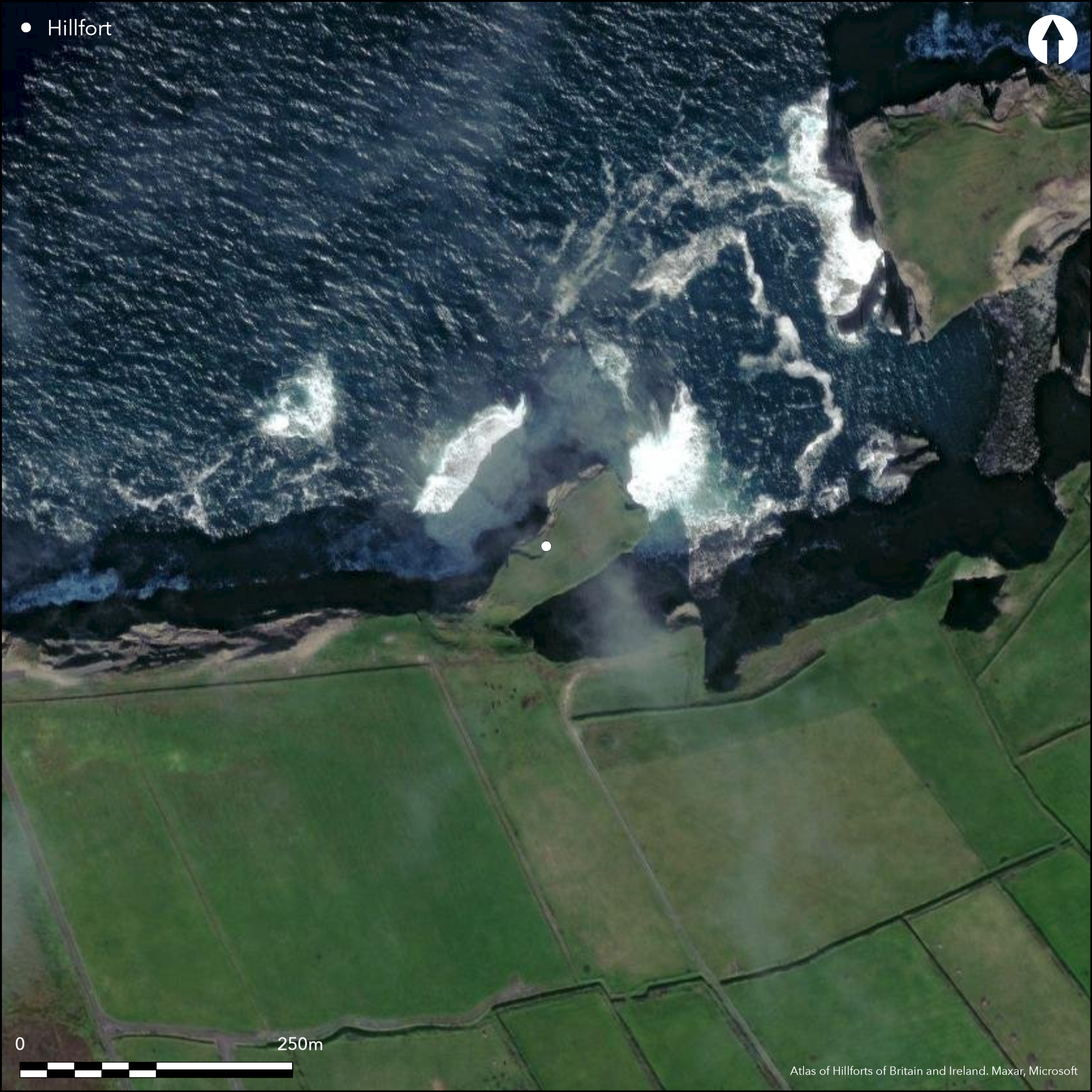
Satellite Imagery
Satellite Imagery
HER: Archaeological Survey of Ireland SMR Database CL064-005001 (None)
NMR: CL 064 (None)
SM: None
NGR: None
X: 475471 Y: 651091 (IRENET95)
This coastal promontory is situated in Cloghaunsavaun townland, Co. Clare. Westropp (1908, 224) suggests the name 'Cloghaunsavaun' is a corruption of 'Dunsavaun'. It is a roughly sub-rectangular headland that projects to the NE from the mainland into Cloghaunsavaun Bay at an altitude of 12m OD. It is defended at the neck on the SW by a Medieval castle, but directly outside this three banks and two intermediate ditches have been drawn across in a shallow arc E-W over a distance of approximately 73m, on the landward side now extending well beyond the 18m wide neck . Westropp records that the sea has cut back 30m into the W flank of the promontory behind the defences, leaving the neck about '95 feet wide' (1908, 224). The innermost bank measures 3.48m high, while the associated external ditch measures 6.4m wide. The medial bank measures 9.1m wide at the base, 3.6m at the top and 2.1m high, while the outer ditch is 6m wide and the outer bank is 7.6m wide at the base, 5.4m at the top and rises 1.8m above the bottom of the ditch and 1m above the level of the field to the S. A central causeway gives access; it is roughly 3m wide and slopes gradually from the S into interior of the the promontory. Apart from the medieval castle, there are no other recorded internal features. The site is currently under pasture.
Citizen Science: ✗
Reliability of Data: Confirmed
Reliability of Interpretation: Confirmed
X: -1095181 Y: 6908763 (EPSG: 3857)
Longitude: -9.83818184933862 Latitude: 52.59680358484062 (EPSG:4326)
Country: Republic of Ireland
Current County or Unitary Authority: Clare
Historic County: Clare
Current Parish/Community/Council/Townland: Cloghaunsavaun
None
| Extant | ✓ |
| Cropmark | ✗ |
| Likely Destroyed | ✗ |
None
| Woodland | ✗ |
| Commercial Forestry Plantation | ✗ |
| Parkland | ✗ |
| Pasture (Grazing) | ✓ |
| Arable | ✗ |
| Scrub/Bracken | ✗ |
| Bare Outcrop | ✗ |
| Heather/Moorland | ✓ |
| Heath | ✗ |
| Built-up | ✗ |
| Coastal Grassland | ✗ |
| Other | ✗ |
This coastal promontory is a roughly sub-rectangular headland that projects to the NE from the mainland into Cloghaunsavaun Bay at an altitude of 12m OD. It is defended to the SW by a Medieval castle directly outside of which are the remains of three banks and two ditches drawn in an arc across the root of the promontory over a distance of 73m E-W.
| Contour Fort | ✗ |
| Partial Contour Fort | ✗ |
| Promontory Fort | ✓ |
| Hillslope Fort | ✗ |
| Level Terrain Fort | ✗ |
| Marsh Fort | ✗ |
| Multiple Enclosure Fort | ✗ |
| Hilltop | ✗ |
| Coastal Promontory | ✓ |
| Inland Promontory | ✗ |
| Valley Bottom | ✗ |
| Knoll/Hillock/Outcrop | ✗ |
| Ridge | ✗ |
| Cliff/Plateau-edge/Scarp | ✗ |
| Hillslope | ✗ |
| Lowland | ✗ |
| Spur | ✗ |
Dominant Topographic Feature: The site is overlooked by higher ground to the S
| North | ✗ |
| Northeast | ✓ |
| East | ✗ |
| Southeast | ✗ |
| South | ✗ |
| Southwest | ✗ |
| West | ✗ |
| Northwest | ✗ |
| Level | ✗ |
Altitude: 12.0m
N/A
There is no dating available for the site
Reliability: D - None
| Pre 1200BC | ✗ |
| 1200BC - 800BC | ✗ |
| 800BC - 400BC | ✗ |
| 400BC - AD50 | ✗ |
| AD50 - AD400 | ✗ |
| AD400 - AD 800 | ✗ |
| Post AD800 | ✗ |
| Unknown | ✓ |
| Pre Hillfort: | None |
| Post Hillfort: | Medieval castle |
The site is depicted as a haurched promontory on the second edition 25-inch OS map. Visited and surveyed by Westropp in 1908.
| 1st Identified Map Depiction (1840): | OS SIX-INCH MAP |
| 1st Identified Written Reference (1908): | Westropp |
Apart from the Medieval castle, there are no other recorded features within the promontory.
None
| None | ✓ |
| Spring | ✗ |
| Stream | ✗ |
| Pool | ✗ |
| Flush | ✗ |
| Well | ✗ |
| Other | ✗ |
Castle
| No Known Features | ✗ |
| Round Stone Structures | ✗ |
| Rectangular Stone Structures | ✓ |
| Curvilinear Platforms | ✗ |
| Other Roundhouse Evidence | ✗ |
| Pits | ✗ |
| Quarry Hollows | ✗ |
| Other | ✗ |
None
| No Known Excavation | ✓ |
| Pits | ✗ |
| Postholes | ✗ |
| Roundhouses | ✗ |
| Rectangular Structures | ✗ |
| Roads/Tracks | ✗ |
| Quarry Hollows | ✗ |
| Other | ✗ |
| Nothing Found | ✗ |
None
| No Known Geophysics | ✓ |
| Pits | ✗ |
| Roundhouses | ✗ |
| Rectangular Structures | ✗ |
| Roads/Tracks | ✗ |
| Quarry Hollows | ✗ |
| Other | ✗ |
| Nothing Found | ✗ |
None
| No Known Finds | ✓ |
| Pottery | ✗ |
| Metal | ✗ |
| Metalworking | ✗ |
| Human Bones | ✗ |
| Animal Bones | ✗ |
| Lithics | ✗ |
| Environmental | ✗ |
| Other | ✗ |
NO APPARENT FEATURES
| APs Not Checked | ✓ |
| None | ✗ |
| Roundhouses | ✗ |
| Rectangular Structures | ✗ |
| Pits | ✗ |
| Postholes | ✗ |
| Roads/Tracks | ✗ |
| Other | ✗ |
The site is accessed via a gap that occurs centrally in the enclosing elements and there is a casueway over the ditches. It is roughly 3m wide and slopes gradually from the S into interior of the promontory.
| 1: | None |
| 2: | None |
Guard Chambers: ✗
Chevaux de Frise: ✗
| 1. Simple Gap (South west): | None |
It is defended at the neck on the SW by a Medieval castle, but directly outside this three banks and two intermediate ditches have been drawn across in a shallow arc E-W over a distance of approximately 73m, on the landward side now extending well beyond the 18m wide neck . The innermost bank measures 3.48m high, while the associated external ditch measures 6.4m wide. The medial bank measures 9.1m wide at the base, 3.6m at the top and 2.1m high, while the outer ditch is 6m wide and the outer bank is 7.6m wide at the base, 5.4m at the top and rises 1.8m above the bottom of the ditch and 1m above the level of the field to the S
| Area 1: | 0.32ha. |
| Total: | 0.32ha. |
Total Footprint Area: 0.58ha.
None
| ✗ | None |
| ✗ | None |
| NE Quadrant: | 0 |
| SE Quadrant: | 3 |
| SW Quadrant: | 0 |
| NW Quadrant: | 0 |
| Total: | 3 |
| Partial Univallate | ✗ |
| Univallate | ✗ |
| Partial Bivallate | ✗ |
| Bivallate | ✗ |
| Partial Multivallate | ✓ |
| Multivallate | ✗ |
| Unknown | ✗ |
| Partial Univallate | ✗ |
| Univallate | ✗ |
| Partial Bivallate | ✗ |
| Bivallate | ✗ |
| Partial Multivallate | ✗ |
| Multivallate | ✗ |
None
| None | ✗ |
| Earthen Bank | ✓ |
| Stone Wall | ✗ |
| Rubble | ✗ |
| Wall-walk | ✗ |
| Evidence of Timber | ✗ |
| Vitrification | ✗ |
| Other Burning | ✗ |
| Palisade | ✗ |
| Counter Scarp Bank | ✗ |
| Berm | ✗ |
| Unfinished | ✗ |
| Other | ✗ |
None
| None | ✗ |
| Earthen Bank | ✗ |
| Stone Wall | ✗ |
| Murus Duplex | ✗ |
| Timber-framed | ✗ |
| Timber-laced | ✗ |
| Vitrification | ✗ |
| Other Burning | ✗ |
| Palisade | ✗ |
| Counter Scarp Bank | ✗ |
| Berm | ✗ |
| Unfinished | ✗ |
| No Known Excavation | ✓ |
| Other | ✗ |
| ✗ | None |
| ✓ | None |
Number of Ditches: 2
| ✗ | None |
Westropp, T.J. Promontory forts in the "Irrus," County Clare. Part II. Loop Head and Cross Group. The Journal of the Royal Society of Antiquaries of Ireland 38 (3), 221-231
Atlas of Hillforts:
Wikidata:
This work is licensed under CC BY-SA 4.0

 and should be cited as:
Lock, Gary and Ralston, Ian. 2024. Atlas of Hillforts of Britain and Ireland. Available at: https://hillforts.arch.ox.ac.uk
Document Version 1.1