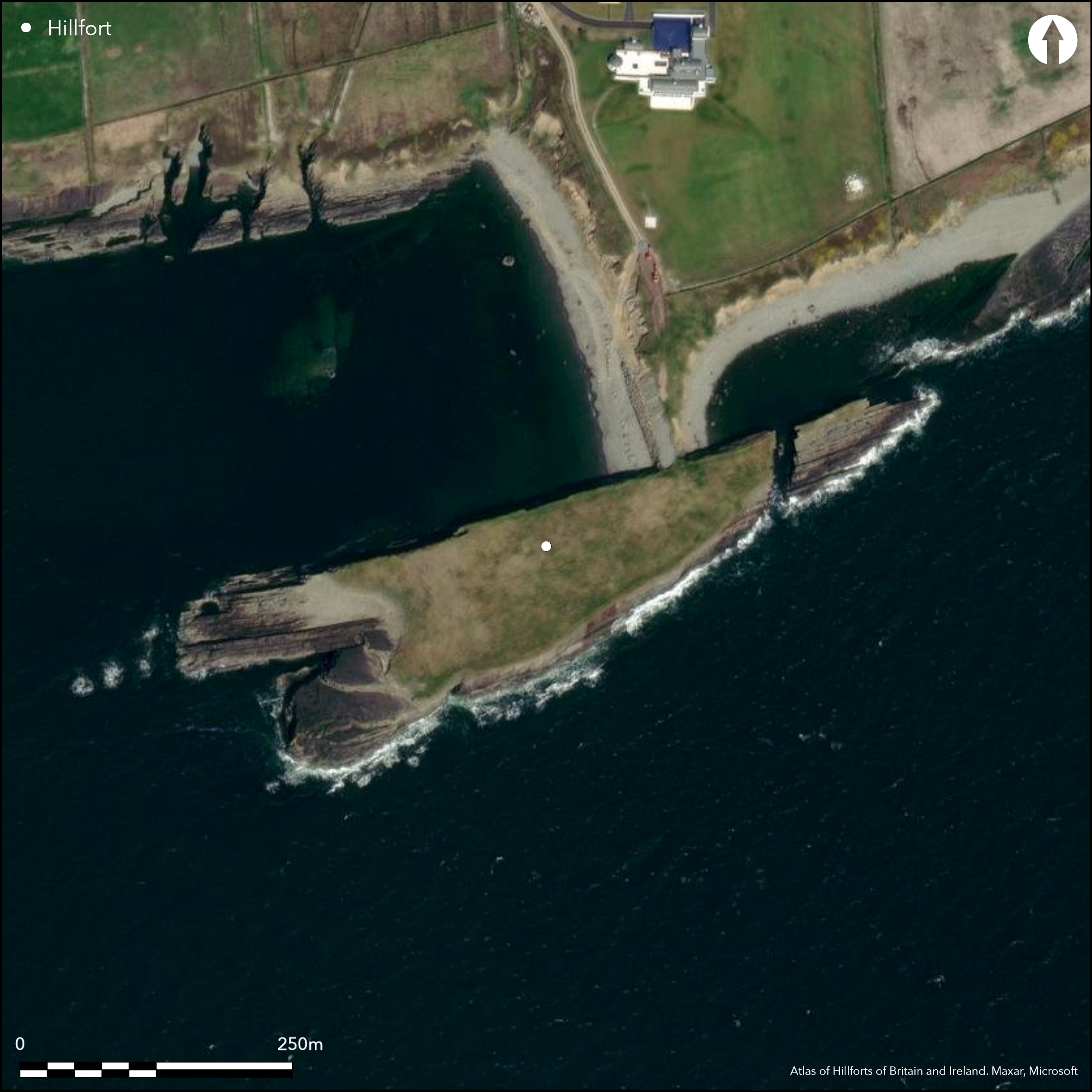
Satellite Imagery
Satellite Imagery
HER: Archaeological Survey of Ireland SMR Database CL071-014 (None)
NMR: CL 071 (None)
SM: None
NGR: None
X: 471839 Y: 646595 (IRENET95)
This coastal promontory is situated at Dunmore Head, two miles E of Loop Head, on low cliffs beside the Shannon Estuary, Co. Clare, forming a T-shaped peninsula at a height of 6m OD and known as 'Horse Island'. The top of the island is wedge-shaped, measuring 267m E W by a maximum of 83m N-S at the W end, and it is connected to the mainland by a narrow neck that contracts from 17m wide to little more than 4m. The inner defences are the more substantial and consist of a ditch, 4.5m wide and 1.5 deep, with a stone wall along its inner edge. The outer line consists of an earthen bank with at least one, and possibly two, external ditches (Lynch and Jones 2009, 57). Westropp noted that a ditch was cut across the neck of this approach and was associated with a dry-stone wall and earthen bank (1908, 226), but the only internal features he recorded were hollows used for burning seaweed to make kelp. That said, a number of shell middens near the entrance were recorded by him, and midden material is eroding out of the fill of a ditch at the neck. The rapid erosion of the promontory fort defences on the narrow isthmus leading from the mainland led to a rescue excavation in 2006 (Lynch 2009, 57). The excavation of Trench A was carried out to examine the stone wall on the inner edge of the inner ditch, where, beneath several layers of stones and sediments, the 0.5m-high remains of a mortared stone wall were revealed. This wall formed the eastern side of an entrance to the promontory. The wall was over 1m wide and the entranceway had a curving splay that widened towards the interior. An in situ stone with a Çmortise hole' protruded from the base of the wall into the entranceway at the outer edge of the entrance (this may have held a wooden element of the doorway, such as a jamb). The entranceway appeared to be cobbled. Samples of limpet shell, charcoal, burnt and unburnt bone were recovered from the exposed ditch section in the cliff face. Trench B was excavated to examine and record the outer defences of the promontory fort, which appeared at first to consist of a single bank and ditch. Exposed in this excavation trench was an earthen bank with an external ditch. A layer of cobbles and stones on the northern side of the bank may be the remains of a wall and a deposit of mottled black and dark-brown silt with some old root casts under the bank may be an old turf layer that formed on top of an earlier bank. Finds from Trench B were limited to some animal bone and iron fragments and small amounts of charcoal (Lynch and Jones 2009, 57-58).
Citizen Science: ✗
Reliability of Data: Confirmed
Reliability of Interpretation: Unconfirmed
X: -1100952 Y: 6901210 (EPSG: 3857)
Longitude: -9.89002457210776 Latitude: 52.5555711779673 (EPSG:4326)
Country: Republic of Ireland
Current County or Unitary Authority: Clare (Horse Island)
Historic County: Clare
Current Parish/Community/Council/Townland: Kilbaha
None
| Extant | ✓ |
| Cropmark | ✗ |
| Likely Destroyed | ✗ |
None
| Woodland | ✗ |
| Commercial Forestry Plantation | ✗ |
| Parkland | ✗ |
| Pasture (Grazing) | ✓ |
| Arable | ✗ |
| Scrub/Bracken | ✗ |
| Bare Outcrop | ✗ |
| Heather/Moorland | ✗ |
| Heath | ✗ |
| Built-up | ✗ |
| Coastal Grassland | ✗ |
| Other | ✗ |
This coastal promontory is situated at Dunmore Head, two miles E of Loop Head, on low cliffs beside the Shannon Estuary. This T-shaped peninsula, known as Horse Island, measures 267m E-W by 83m N-S. It is connected to the mainland by a narrow neck that contracts from 17m to little more than 4m wide and is situated at an altitude of 6m OD
| Contour Fort | ✗ |
| Partial Contour Fort | ✗ |
| Promontory Fort | ✓ |
| Hillslope Fort | ✗ |
| Level Terrain Fort | ✗ |
| Marsh Fort | ✗ |
| Multiple Enclosure Fort | ✗ |
| Hilltop | ✗ |
| Coastal Promontory | ✓ |
| Inland Promontory | ✗ |
| Valley Bottom | ✗ |
| Knoll/Hillock/Outcrop | ✗ |
| Ridge | ✗ |
| Cliff/Plateau-edge/Scarp | ✗ |
| Hillslope | ✗ |
| Lowland | ✗ |
| Spur | ✗ |
Dominant Topographic Feature: The site is overlooked to the N
| North | ✗ |
| Northeast | ✗ |
| East | ✗ |
| Southeast | ✗ |
| South | ✗ |
| Southwest | ✗ |
| West | ✗ |
| Northwest | ✗ |
| Level | ✓ |
Altitude: 6.0m
N/A
There is no dating available for the site at this time
Reliability: D - None
| Pre 1200BC | ✗ |
| 1200BC - 800BC | ✗ |
| 800BC - 400BC | ✗ |
| 400BC - AD50 | ✗ |
| AD50 - AD400 | ✗ |
| AD400 - AD 800 | ✗ |
| Post AD800 | ✗ |
| Unknown | ✓ |
| Pre Hillfort: | None |
| Post Hillfort: | None |
The site is depicted as 'Dunmore Head' on the first edition (1840s) OS six-inch map. Visited and surveyed by Westropp in 1908. The rapid erosion of the promontory fort defences on the narrow isthmus leading from the mainland to Horse Island led to a rescue excavation in 2006 where the morphology of the defences were defined (Lynch 2009, 57).
| 1st Identified Map Depiction (1840): | OS six-inch mapping |
| 1st Identified Written Reference (1908): | Westropp |
| Excavation (2006): | Michael Lynch and Carlton Jones |
No internal features were noted by Westropp other than hollows used for burning seaweed to make kelp.
None
| None | ✓ |
| Spring | ✗ |
| Stream | ✗ |
| Pool | ✗ |
| Flush | ✗ |
| Well | ✗ |
| Other | ✗ |
None
| No Known Features | ✓ |
| Round Stone Structures | ✗ |
| Rectangular Stone Structures | ✗ |
| Curvilinear Platforms | ✗ |
| Other Roundhouse Evidence | ✗ |
| Pits | ✗ |
| Quarry Hollows | ✗ |
| Other | ✗ |
None
| No Known Excavation | ✓ |
| Pits | ✗ |
| Postholes | ✗ |
| Roundhouses | ✗ |
| Rectangular Structures | ✗ |
| Roads/Tracks | ✗ |
| Quarry Hollows | ✗ |
| Other | ✗ |
| Nothing Found | ✗ |
None
| No Known Geophysics | ✓ |
| Pits | ✗ |
| Roundhouses | ✗ |
| Rectangular Structures | ✗ |
| Roads/Tracks | ✗ |
| Quarry Hollows | ✗ |
| Other | ✗ |
| Nothing Found | ✗ |
Samples of limpet shell, charcoal, burnt and unburnt bone were recovered from the exposed ditch section in the cliff face. Finds from Trench B were limited to some animal bone and iron fragments and small amounts of charcoal.
| No Known Finds | ✗ |
| Pottery | ✗ |
| Metal | ✓ |
| Metalworking | ✗ |
| Human Bones | ✗ |
| Animal Bones | ✓ |
| Lithics | ✗ |
| Environmental | ✓ |
| Other | ✗ |
NO APPARENT FEATURES
| APs Not Checked | ✓ |
| None | ✗ |
| Roundhouses | ✗ |
| Rectangular Structures | ✗ |
| Pits | ✗ |
| Postholes | ✗ |
| Roads/Tracks | ✗ |
| Other | ✗ |
Horse Island is accessed via a narrow neck connected to the mainland. The inner wall formed the eastern side of the entrance. The wall was over 1m wide and the entranceway had a curving splay that widened towards the interior. An in situ stone with a Çmortise hole protruded from the base of the wall into the entranceway at the outer edge of the entrance (this may have held a wooden element of the doorway, such as a jamb). The entranceway appeared to be cobbled
| 1: | None |
| 2: | None |
Guard Chambers: ✗
Chevaux de Frise: ✗
| 1. Out-turned (North): | None |
The inner defence is the more substantial and consists of a ditch, 4.5m wide and 1.5 deep, with a stone wall along its inner edge. The outer line of defence consists of an earthen bank with at least one, and possibly two, external ditches (Lynch and Jones 2009, 57). Excavation across the inner defences revealed the 0.5m-high remains of a mortared stone wall. The wall was over 1m wide and the entranceway had a curving splay that widened towards the interior. The outer defences consist of a single bank and ditch. A layer of cobbles and stones on the northern side of the bank may be the remains of a wall and a deposit of mottled black and dark-brown silt with some old root casts under the bank may be an old turf layer that formed on top of an earlier bank
| Area 1: | 1.5ha. |
| Total: | 1.5ha. |
Total Footprint Area: 1.86ha.
None
| ✗ | None |
| ✗ | None |
| NE Quadrant: | 2 |
| SE Quadrant: | 0 |
| SW Quadrant: | 0 |
| NW Quadrant: | 0 |
| Total: | 2 |
| Partial Univallate | ✗ |
| Univallate | ✗ |
| Partial Bivallate | ✓ |
| Bivallate | ✗ |
| Partial Multivallate | ✗ |
| Multivallate | ✗ |
| Unknown | ✗ |
| Partial Univallate | ✗ |
| Univallate | ✗ |
| Partial Bivallate | ✗ |
| Bivallate | ✗ |
| Partial Multivallate | ✗ |
| Multivallate | ✗ |
None
| None | ✗ |
| Earthen Bank | ✓ |
| Stone Wall | ✓ |
| Rubble | ✗ |
| Wall-walk | ✗ |
| Evidence of Timber | ✗ |
| Vitrification | ✗ |
| Other Burning | ✗ |
| Palisade | ✗ |
| Counter Scarp Bank | ✗ |
| Berm | ✗ |
| Unfinished | ✗ |
| Other | ✗ |
And ditches
| None | ✗ |
| Earthen Bank | ✓ |
| Stone Wall | ✓ |
| Murus Duplex | ✗ |
| Timber-framed | ✗ |
| Timber-laced | ✗ |
| Vitrification | ✗ |
| Other Burning | ✗ |
| Palisade | ✗ |
| Counter Scarp Bank | ✗ |
| Berm | ✗ |
| Unfinished | ✗ |
| No Known Excavation | ✗ |
| Other | ✓ |
| ✗ | None |
| ✓ | None |
Number of Ditches: 2
| ✗ | None |
Lynch, M. and Jones, C. 2009 'Dunmore Head, Horse Island, Kilbaha South'. In I. Bennett (ed.), Excavations 2006: summary accounts of archaeological excavations in Ireland, 57 (no. 252). Bray. Wordwell.
Westropp, T.J. Promontory forts in the "Irrus," County Clare. Part II. Loop Head and Cross Group. The Journal of the Royal Society of Antiquaries of Ireland 38 (3), 221-231
Atlas of Hillforts:
Wikidata:
This work is licensed under CC BY-SA 4.0

 and should be cited as:
Lock, Gary and Ralston, Ian. 2024. Atlas of Hillforts of Britain and Ireland. Available at: https://hillforts.arch.ox.ac.uk
Document Version 1.1