Satellite Imagery
Satellite Imagery
HER: Archaeological Survey of Ireland SMR Database CL065-027 (None)
NMR: CL 065 (None)
SM: None
NGR: None
X: 477797 Y: 652554 (IRENET95)
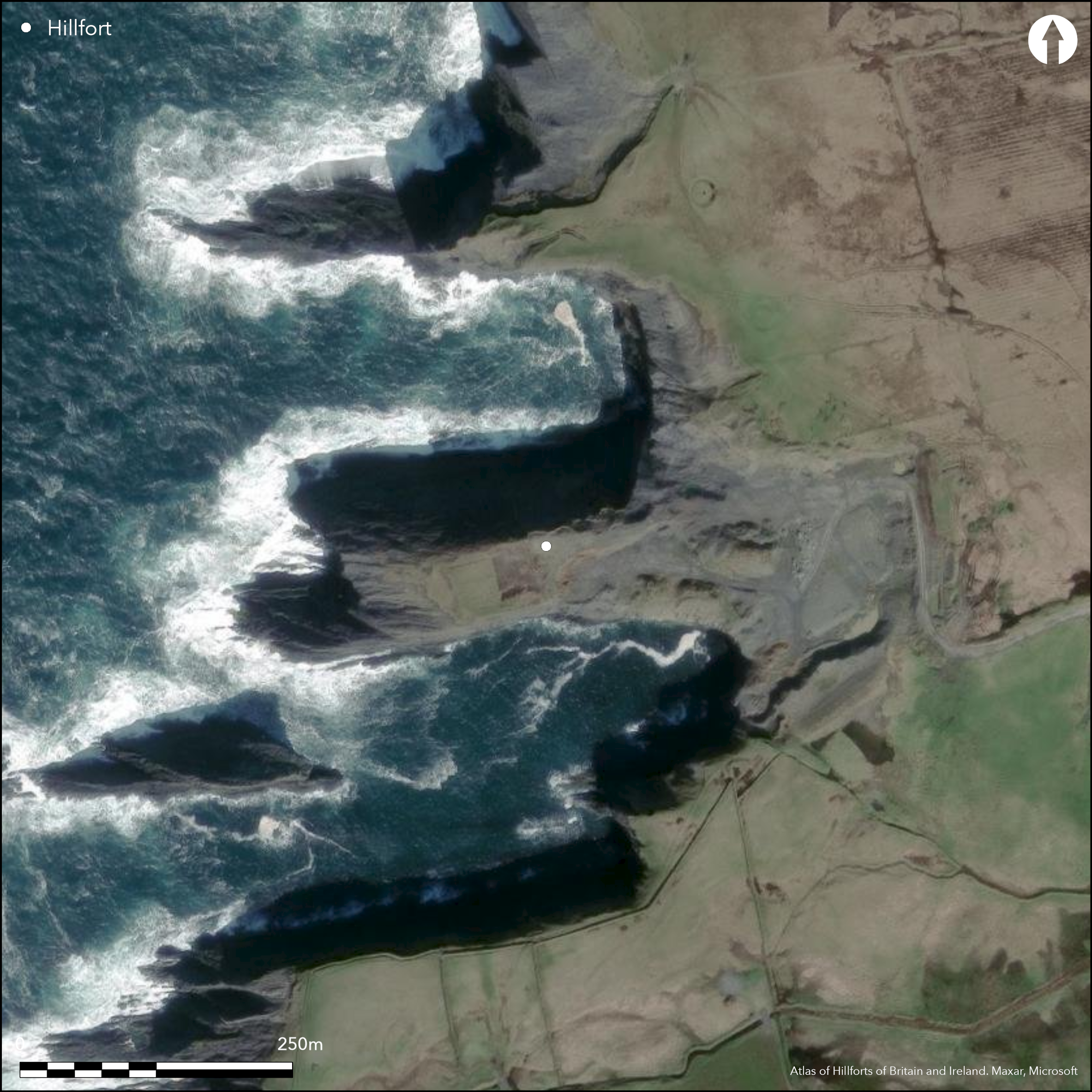
This coastal promontory, depicted as an enclosed headland named 'Doondoillroe' on the first edition (1839) OS six-inch map, is situated immediately N of 'Gull Island' c. 1.5km SW of Tullig Village, Co. Clare. Westropp notes that it derives the last part of its name from the 'the red iron scum, oozing down the cliff, which has also originated several fort and other names in the district' (1908, 222). It is a roughly rectangular headland 43m wide and extending 250m out into the sea on the W at an altitude of 14m OD. The promontory was defended to the E by two banks and a medial ditch, though only the S end of the outer bank now survives. Westropp notes that the 'earthworks are 207 feet long, and about 40 feet of their lines at the southern end has been entirely dug away in recent times' (1908, 224). The two banks were composed of 'splinters of shale and little earth', the inner 13.7m wide at the base and 3.6m at the top and rising 4.5m over the bottom of the ditch. The latter was 4.2m wide and 2.1m deep, and on the N it was almost completely filled in to the level of the interior. The surviving fragment of the outer bank is 2.1m high and 7m wide. Westropp observed slight traces of another bank, nearly levelled, 3.6m wide and the same distance outside the outer bank (Westropp 1908), suggesting that there may have been additional defences. A causeway crossed the ditch from 27m to 30m from the N cliff and measured approximately 6m wide. Westropp recorded no internal features. The site has been heavily quarried during the later twentieth century and has been almost completely destroyed.
Citizen Science: ✗
Reliability of Data: Confirmed
Reliability of Interpretation: Confirmed
X: -1091422 Y: 6911269 (EPSG: 3857)
Longitude: -9.804406481941498 Latitude: 52.610474333758525 (EPSG:4326)
Country: Republic of Ireland
Current County or Unitary Authority: Clare
Historic County: Clare
Current Parish/Community/Council/Townland: Tullig
Gravel quarrying
| Extant | ✗ |
| Cropmark | ✗ |
| Likely Destroyed | ✓ |
None
| Woodland | ✗ |
| Commercial Forestry Plantation | ✗ |
| Parkland | ✗ |
| Pasture (Grazing) | ✗ |
| Arable | ✗ |
| Scrub/Bracken | ✗ |
| Bare Outcrop | ✗ |
| Heather/Moorland | ✗ |
| Heath | ✗ |
| Built-up | ✗ |
| Coastal Grassland | ✓ |
| Other | ✓ |
This coastal promontory is roughly rectangular, measuring 250m E-W by 43m N-S, and projecting W from the mainland at an altitude of 14m OD. The promontory was defended to the E by two banks and a medial ditch
| Contour Fort | ✗ |
| Partial Contour Fort | ✗ |
| Promontory Fort | ✓ |
| Hillslope Fort | ✗ |
| Level Terrain Fort | ✗ |
| Marsh Fort | ✗ |
| Multiple Enclosure Fort | ✗ |
| Hilltop | ✗ |
| Coastal Promontory | ✓ |
| Inland Promontory | ✗ |
| Valley Bottom | ✗ |
| Knoll/Hillock/Outcrop | ✗ |
| Ridge | ✗ |
| Cliff/Plateau-edge/Scarp | ✗ |
| Hillslope | ✗ |
| Lowland | ✗ |
| Spur | ✗ |
Dominant Topographic Feature: W-facing promontory
| North | ✗ |
| Northeast | ✗ |
| East | ✗ |
| Southeast | ✗ |
| South | ✗ |
| Southwest | ✗ |
| West | ✗ |
| Northwest | ✗ |
| Level | ✓ |
Altitude: 14.0m
N/A
There is no dating available for the site
Reliability: D - None
| Pre 1200BC | ✗ |
| 1200BC - 800BC | ✗ |
| 800BC - 400BC | ✗ |
| 400BC - AD50 | ✗ |
| AD50 - AD400 | ✗ |
| AD400 - AD 800 | ✗ |
| Post AD800 | ✗ |
| Unknown | ✓ |
| Pre Hillfort: | None |
| Post Hillfort: | Gravel quarrying |
The site is enclosed and depicted as 'Doondoillroe' on the first edition (1840s) OS six-inch map. Visited and surveyed by Westropp in 1908 who recorded the defences.
| 1st Identified Map Depiction (1840): | OS six-inch mapping |
| Earthwork Survey (1908): | Thomas Westropp |
There are no recorded internal features
None
| None | ✓ |
| Spring | ✗ |
| Stream | ✗ |
| Pool | ✗ |
| Flush | ✗ |
| Well | ✗ |
| Other | ✗ |
None
| No Known Features | ✓ |
| Round Stone Structures | ✗ |
| Rectangular Stone Structures | ✗ |
| Curvilinear Platforms | ✗ |
| Other Roundhouse Evidence | ✗ |
| Pits | ✗ |
| Quarry Hollows | ✗ |
| Other | ✗ |
None
| No Known Excavation | ✓ |
| Pits | ✗ |
| Postholes | ✗ |
| Roundhouses | ✗ |
| Rectangular Structures | ✗ |
| Roads/Tracks | ✗ |
| Quarry Hollows | ✗ |
| Other | ✗ |
| Nothing Found | ✗ |
None
| No Known Geophysics | ✓ |
| Pits | ✗ |
| Roundhouses | ✗ |
| Rectangular Structures | ✗ |
| Roads/Tracks | ✗ |
| Quarry Hollows | ✗ |
| Other | ✗ |
| Nothing Found | ✗ |
None
| No Known Finds | ✓ |
| Pottery | ✗ |
| Metal | ✗ |
| Metalworking | ✗ |
| Human Bones | ✗ |
| Animal Bones | ✗ |
| Lithics | ✗ |
| Environmental | ✗ |
| Other | ✗ |
Quarrying
| APs Not Checked | ✗ |
| None | ✗ |
| Roundhouses | ✗ |
| Rectangular Structures | ✗ |
| Pits | ✗ |
| Postholes | ✗ |
| Roads/Tracks | ✗ |
| Other | ✓ |
A causeway crossed the ditch 27m to 30m from the N cliff. This measured approximately 6m wide.
| 1: | None |
| 2: | None |
Guard Chambers: ✗
Chevaux de Frise: ✗
| 1. Simple Gap (East): | None |
The promontory was defended on the E by two banks and a medial ditch. Westropp notes that the 'earthworks are 207 feet long, and about 40 feet of their lines at the southern end has been entirely dug away in recent times' (1908, 224). The banks were composed of 'splinters of shale and little earth', the inner rising 4.5m over the bottom of the ditch and measuring 13.7m wide at the base and 3.6m at the top. The ditch was 4.2m wide, its N end almost completely filled in to the level of the interior. On average the ditch was 2.1m deep. Only the S end of the outer bank now survives, measuring 2.1m high and 7m wide.
| Area 1: | 0.79ha. |
| Total: | 0.79ha. |
Total Footprint Area: 1.7ha.
None
| ✗ | None |
| ✗ | None |
| NE Quadrant: | 2 |
| SE Quadrant: | 0 |
| SW Quadrant: | 0 |
| NW Quadrant: | 0 |
| Total: | 2 |
| Partial Univallate | ✗ |
| Univallate | ✗ |
| Partial Bivallate | ✓ |
| Bivallate | ✗ |
| Partial Multivallate | ✗ |
| Multivallate | ✗ |
| Unknown | ✗ |
| Partial Univallate | ✗ |
| Univallate | ✗ |
| Partial Bivallate | ✗ |
| Bivallate | ✗ |
| Partial Multivallate | ✗ |
| Multivallate | ✗ |
None
| None | ✗ |
| Earthen Bank | ✓ |
| Stone Wall | ✗ |
| Rubble | ✗ |
| Wall-walk | ✗ |
| Evidence of Timber | ✗ |
| Vitrification | ✗ |
| Other Burning | ✗ |
| Palisade | ✗ |
| Counter Scarp Bank | ✗ |
| Berm | ✗ |
| Unfinished | ✗ |
| Other | ✗ |
None
| None | ✗ |
| Earthen Bank | ✗ |
| Stone Wall | ✗ |
| Murus Duplex | ✗ |
| Timber-framed | ✗ |
| Timber-laced | ✗ |
| Vitrification | ✗ |
| Other Burning | ✗ |
| Palisade | ✗ |
| Counter Scarp Bank | ✗ |
| Berm | ✗ |
| Unfinished | ✗ |
| No Known Excavation | ✓ |
| Other | ✗ |
| ✗ | None |
| ✓ | None |
Number of Ditches: 1
| ✗ | None |
Westropp, T.J.1908. Promontory forts in the "Irrus," County Clare. Part II. Loop Head and Cross Group. The Journal of the Royal Society of Antiquaries of Ireland 38 (3), 221-231.
Atlas of Hillforts:
Wikidata:
This work is licensed under CC BY-SA 4.0

 and should be cited as:
Lock, Gary and Ralston, Ian. 2024. Atlas of Hillforts of Britain and Ireland. Available at: https://hillforts.arch.ox.ac.uk
Document Version 1.1