Satellite Imagery
Satellite Imagery
HER: Archaeological Survey of Ireland SMR Database CL014-010001 (None)
NMR: CL 014 (None)
SM: None
NGR: None
X: 501330 Y: 689623 (IRENET95)
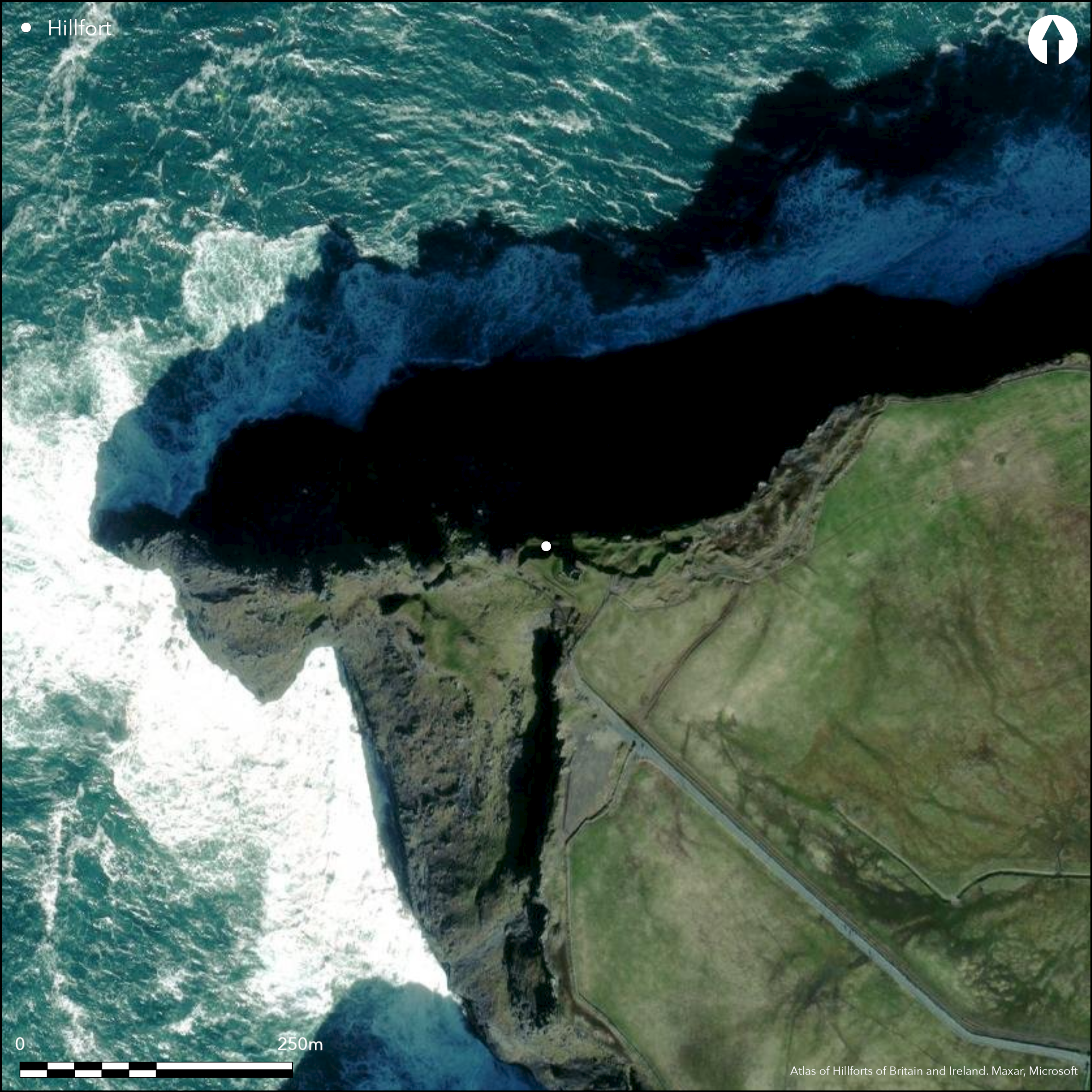
This coastal promontory, depicted as 'Moher Fort' on the first edition OS six inch map (1839), is situated at 'Hags Head' on the cliffs of Moher, Co. Clare. It is a triangular headland of c. 0.37ha that projects NW from the mainland with an eroding cliff face on the S side. Frost (1893) notes that the name 'Moher' is derived from 'an ancient caher or stone fort called Moher ui Ruaidhin, (i.e., O'Ruaidhin's fort), that stood near Hag's Head. About the beginning of this century it was pulled down to supply materials for the erection of the Telegraph tower in the vicinity'. Westropp states that the fort was 'unfortunately levelled as material for the telegraph tower, built in its ambit in 1808' (1911). He observed that in 1780 John Loyd described the site as being located on 'the summit of a very stupendous cliff surrounded with a stone wall, a part of which is up. Inside of it is a green plain' (ibid). Unfortunately, there is no other description of the original defences. Westropp notes that if the tower was made of the material of the fort, the 'masonry must have been very small'. There is no other information available as to the morphology of this possible fortified headland. The triangular summit of are of the promontory around the telegraph tower is no more than 0.11ha, though the overall footprint of the headland is considerably larger.
Citizen Science: ✗
Reliability of Data: Unconfirmed
Reliability of Interpretation: Unconfirmed
X: -1053999 Y: 6973444 (EPSG: 3857)
Longitude: -9.46823229327679 Latitude: 52.948316510064586 (EPSG:4326)
Country: Republic of Ireland
Current County or Unitary Authority: Clare
Historic County: Clare
Current Parish/Community/Council/Townland: Ballylan
None
| Extant | ✗ |
| Cropmark | ✗ |
| Likely Destroyed | ✓ |
None
| Woodland | ✗ |
| Commercial Forestry Plantation | ✗ |
| Parkland | ✗ |
| Pasture (Grazing) | ✓ |
| Arable | ✗ |
| Scrub/Bracken | ✗ |
| Bare Outcrop | ✗ |
| Heather/Moorland | ✓ |
| Heath | ✗ |
| Built-up | ✗ |
| Coastal Grassland | ✗ |
| Other | ✗ |
The site is situated at 'Hags Head' on the cliffs of Moher, Co. Clare. It is a triangular headland that projects NW from the mainland with an eroding cliff face on the S side.
| Contour Fort | ✗ |
| Partial Contour Fort | ✗ |
| Promontory Fort | ✓ |
| Hillslope Fort | ✗ |
| Level Terrain Fort | ✗ |
| Marsh Fort | ✗ |
| Multiple Enclosure Fort | ✗ |
| Hilltop | ✗ |
| Coastal Promontory | ✓ |
| Inland Promontory | ✗ |
| Valley Bottom | ✗ |
| Knoll/Hillock/Outcrop | ✗ |
| Ridge | ✗ |
| Cliff/Plateau-edge/Scarp | ✗ |
| Hillslope | ✗ |
| Lowland | ✗ |
| Spur | ✗ |
Dominant Topographic Feature: None
| North | ✗ |
| Northeast | ✗ |
| East | ✗ |
| Southeast | ✗ |
| South | ✗ |
| Southwest | ✗ |
| West | ✗ |
| Northwest | ✗ |
| Level | ✓ |
Altitude: 83.0m
N/A
There is no dating available for the site
Reliability: D - None
| Pre 1200BC | ✗ |
| 1200BC - 800BC | ✗ |
| 800BC - 400BC | ✗ |
| 400BC - AD50 | ✗ |
| AD50 - AD400 | ✗ |
| AD400 - AD 800 | ✗ |
| Post AD800 | ✗ |
| Unknown | ✓ |
| Pre Hillfort: | None |
| Post Hillfort: | Napoleonic signalling tower |
The site is depicted as 'Moher Fort' on the first edition OS six inch map (1839). Fort observed by John Loyd in 1780 but Frost, writing in 1893 notes that the site had been levelled in 1808 for the construction of a telegraph tower. Visited by Thomas Westropp in 1911.
| 1st Identified Written Reference (1780): | John Loyd |
| 1st Identified Map Depiction (1839): | OS six-inch mapping |
| Other (1893): | Frost |
Telegraph Tower
None
| None | ✓ |
| Spring | ✗ |
| Stream | ✗ |
| Pool | ✗ |
| Flush | ✗ |
| Well | ✗ |
| Other | ✗ |
None
| No Known Features | ✓ |
| Round Stone Structures | ✗ |
| Rectangular Stone Structures | ✗ |
| Curvilinear Platforms | ✗ |
| Other Roundhouse Evidence | ✗ |
| Pits | ✗ |
| Quarry Hollows | ✗ |
| Other | ✗ |
None
| No Known Excavation | ✓ |
| Pits | ✗ |
| Postholes | ✗ |
| Roundhouses | ✗ |
| Rectangular Structures | ✗ |
| Roads/Tracks | ✗ |
| Quarry Hollows | ✗ |
| Other | ✗ |
| Nothing Found | ✗ |
None
| No Known Geophysics | ✓ |
| Pits | ✗ |
| Roundhouses | ✗ |
| Rectangular Structures | ✗ |
| Roads/Tracks | ✗ |
| Quarry Hollows | ✗ |
| Other | ✗ |
| Nothing Found | ✗ |
None
| No Known Finds | ✓ |
| Pottery | ✗ |
| Metal | ✗ |
| Metalworking | ✗ |
| Human Bones | ✗ |
| Animal Bones | ✗ |
| Lithics | ✗ |
| Environmental | ✗ |
| Other | ✗ |
NO APPARENT FEATURES
| APs Not Checked | ✓ |
| None | ✗ |
| Roundhouses | ✗ |
| Rectangular Structures | ✗ |
| Pits | ✗ |
| Postholes | ✗ |
| Roads/Tracks | ✗ |
| Other | ✗ |
None known
| 0: | None |
| 2: | None |
Guard Chambers: ✗
Chevaux de Frise: ✗
There are no visible banks, ditches or walls associated with an early promontory fort
| Area 1: | 0.11ha. |
| Total: | 0.11ha. |
Total Footprint Area: Noneha.
None
| ✗ | None |
| ✗ | None |
| NE Quadrant: | 0 |
| SE Quadrant: | 0 |
| SW Quadrant: | 0 |
| NW Quadrant: | 0 |
| Total: | 0 |
| Partial Univallate | ✗ |
| Univallate | ✗ |
| Partial Bivallate | ✗ |
| Bivallate | ✗ |
| Partial Multivallate | ✗ |
| Multivallate | ✗ |
| Unknown | ✓ |
| Partial Univallate | ✗ |
| Univallate | ✗ |
| Partial Bivallate | ✗ |
| Bivallate | ✗ |
| Partial Multivallate | ✗ |
| Multivallate | ✗ |
None
| None | ✓ |
| Earthen Bank | ✗ |
| Stone Wall | ✗ |
| Rubble | ✗ |
| Wall-walk | ✗ |
| Evidence of Timber | ✗ |
| Vitrification | ✗ |
| Other Burning | ✗ |
| Palisade | ✗ |
| Counter Scarp Bank | ✗ |
| Berm | ✗ |
| Unfinished | ✗ |
| Other | ✗ |
None
| None | ✗ |
| Earthen Bank | ✗ |
| Stone Wall | ✗ |
| Murus Duplex | ✗ |
| Timber-framed | ✗ |
| Timber-laced | ✗ |
| Vitrification | ✗ |
| Other Burning | ✗ |
| Palisade | ✗ |
| Counter Scarp Bank | ✗ |
| Berm | ✗ |
| Unfinished | ✗ |
| No Known Excavation | ✓ |
| Other | ✗ |
| ✗ | None |
| ✗ | None |
Number of Ditches: 0
| ✗ | None |
Frost, J. 1893. The History and Topography of the County of Clare
Westropp, T. J. 1911. Prehistoric Remains (Forts and Dolmens) in the Burren, Co. Clare. Journal of the Royal Society of Antiquaries of Ireland 41, 343-367.
Atlas of Hillforts:
Wikidata:
This work is licensed under CC BY-SA 4.0

 and should be cited as:
Lock, Gary and Ralston, Ian. 2024. Atlas of Hillforts of Britain and Ireland. Available at: https://hillforts.arch.ox.ac.uk
Document Version 1.1