Satellite Imagery
Satellite Imagery
HER: Archaeological Survey of Ireland SMR Database CL038-002 (None)
NMR: CL 038 (None)
SM: None
NGR: None
X: 498000 Y: 674531 (IRENET95)
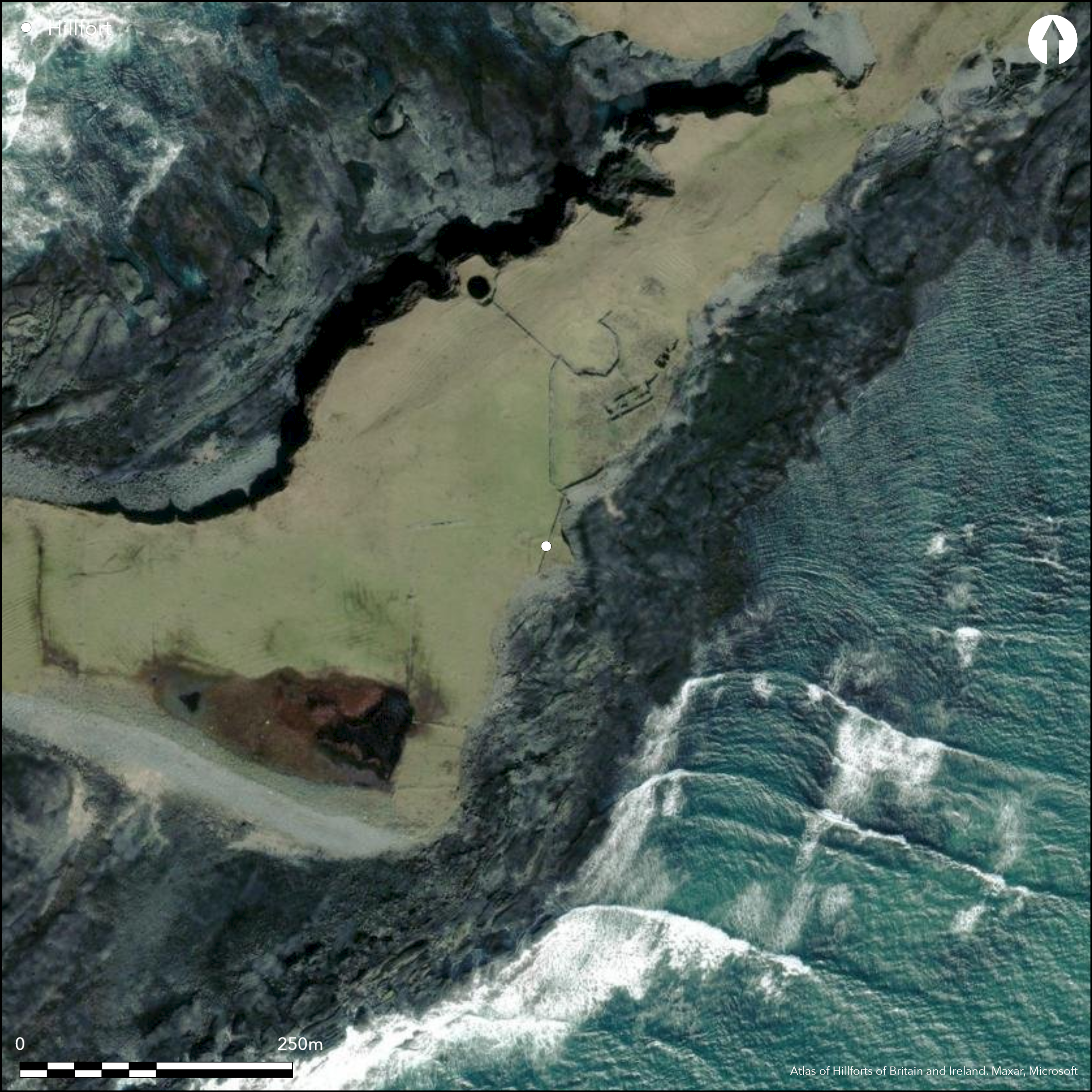
This coastal promontory enclosure is situated on the E end of Mutton Island at 'Coonnaluinga Cove' off the W coast of Co. Clare. It occupies a triangular headland that barely projects SE from the Island at an altitude of 4m OD. it is not depicted as a fortified headland on any edition of the OS six-inch maps but is marked as the location of 'Port Tobacco Cave' on the first edition (1842) map. Samuel Lewis, writing in 1837 gives this account of Mutton Island: 'On its shores are some curious natural caves, formerly used by smugglers for storing contraband goods'. He describes the island as containing '210 statute acres of excellent land for feeding oxen and sheep, particularly the latter; hence the name "Mutton Island" from the fine flavour of the mutton'. The small headland is enclosed by an L-shaped earthen bank and external ditch measuring 34.8m in overall length and enclosing a small area of no more than 0.03ha. A possible rectangular structure, measuring 9m NE-SW by 7m NW-SE, is recorded immediately outside the enclosure at the angle in its perimeter, while a later field boundary bisects the interior from NNE to SSW. There are no other recorded internal features and the site is currently under pasture. The satellite imagery gives the impression of a rectangular enclosure that has lost its E and S sides to erosion of the cliff-edge
Citizen Science: ✗
Reliability of Data: Confirmed
Reliability of Interpretation: Unconfirmed
X: -1058986 Y: 6948317 (EPSG: 3857)
Longitude: -9.513036816406164 Latitude: 52.81210027123778 (EPSG:4326)
Country: Republic of Ireland
Current County or Unitary Authority: Clare (Mutton Island)
Historic County: Clare
Current Parish/Community/Council/Townland: Mutton Island
None
| Extant | ✓ |
| Cropmark | ✗ |
| Likely Destroyed | ✗ |
None
| Woodland | ✗ |
| Commercial Forestry Plantation | ✗ |
| Parkland | ✗ |
| Pasture (Grazing) | ✓ |
| Arable | ✗ |
| Scrub/Bracken | ✗ |
| Bare Outcrop | ✗ |
| Heather/Moorland | ✗ |
| Heath | ✗ |
| Built-up | ✗ |
| Coastal Grassland | ✗ |
| Other | ✗ |
This possible coastal promontory is situated on the E end of Mutton Island at 'Coonnaluinga Cove' off the W coast of Co. Clare. It is a triangular headland on the E coast of the Island at an altitude of 4m OD.
| Contour Fort | ✗ |
| Partial Contour Fort | ✗ |
| Promontory Fort | ✓ |
| Hillslope Fort | ✗ |
| Level Terrain Fort | ✗ |
| Marsh Fort | ✗ |
| Multiple Enclosure Fort | ✗ |
| Hilltop | ✗ |
| Coastal Promontory | ✓ |
| Inland Promontory | ✗ |
| Valley Bottom | ✗ |
| Knoll/Hillock/Outcrop | ✗ |
| Ridge | ✗ |
| Cliff/Plateau-edge/Scarp | ✗ |
| Hillslope | ✗ |
| Lowland | ✗ |
| Spur | ✗ |
Dominant Topographic Feature: None
| North | ✗ |
| Northeast | ✗ |
| East | ✗ |
| Southeast | ✗ |
| South | ✗ |
| Southwest | ✗ |
| West | ✗ |
| Northwest | ✗ |
| Level | ✓ |
Altitude: 4.0m
N/A
There is no dating available for the site
Reliability: D - None
| Pre 1200BC | ✗ |
| 1200BC - 800BC | ✗ |
| 800BC - 400BC | ✗ |
| 400BC - AD50 | ✗ |
| AD50 - AD400 | ✗ |
| AD400 - AD 800 | ✗ |
| Post AD800 | ✗ |
| Unknown | ✓ |
| Pre Hillfort: | None |
| Post Hillfort: | None |
The site is not depicted on any edition of the OS six-inch maps. Island mentioned by Samuel Lewis in 1837 while T.J. Westropp, the antiquarian and surveyor, visited the island several times. According to the "Annals of the Four Masters" the island was once called Fitha Island and it formed part of the mainland until the day "the sea swelled so high that it burst its boundaries, overflowing a large tract of country, and drowning over 1,000 persons." This happened on March 16th, 804. Some reports describe it as an earthquake, others as a tidal wave when "the sea divided the island of Fitha into three parts." These three islands are Mutton Island, Inismattle (or Illanwattle) and Roanshee (or Carrig na Ron). There is a fourth island in the area called Carraig Aolacan.
| 1st Identified Written Reference (1837): | Samuel Lewis |
| Other (1905): | T.J. Westropp |
There are no recorded internal features
None
| None | ✓ |
| Spring | ✗ |
| Stream | ✗ |
| Pool | ✗ |
| Flush | ✗ |
| Well | ✗ |
| Other | ✗ |
None
| No Known Features | ✓ |
| Round Stone Structures | ✗ |
| Rectangular Stone Structures | ✗ |
| Curvilinear Platforms | ✗ |
| Other Roundhouse Evidence | ✗ |
| Pits | ✗ |
| Quarry Hollows | ✗ |
| Other | ✗ |
None
| No Known Excavation | ✓ |
| Pits | ✗ |
| Postholes | ✗ |
| Roundhouses | ✗ |
| Rectangular Structures | ✗ |
| Roads/Tracks | ✗ |
| Quarry Hollows | ✗ |
| Other | ✗ |
| Nothing Found | ✗ |
None
| No Known Geophysics | ✓ |
| Pits | ✗ |
| Roundhouses | ✗ |
| Rectangular Structures | ✗ |
| Roads/Tracks | ✗ |
| Quarry Hollows | ✗ |
| Other | ✗ |
| Nothing Found | ✗ |
None
| No Known Finds | ✓ |
| Pottery | ✗ |
| Metal | ✗ |
| Metalworking | ✗ |
| Human Bones | ✗ |
| Animal Bones | ✗ |
| Lithics | ✗ |
| Environmental | ✗ |
| Other | ✗ |
NO APPARENT FEATURES
| APs Not Checked | ✓ |
| None | ✗ |
| Roundhouses | ✗ |
| Rectangular Structures | ✗ |
| Pits | ✗ |
| Postholes | ✗ |
| Roads/Tracks | ✗ |
| Other | ✗ |
There are no recorded entrances
| 0: | None |
| 2: | None |
Guard Chambers: ✗
Chevaux de Frise: ✗
The small headland is enclosed by an L-shaped earthen bank and external ditch measuring 34.8m in overall length.
| Area 1: | 0.03ha. |
| Total: | 0.03ha. |
Total Footprint Area: 0.04ha.
None
| ✗ | None |
| ✗ | None |
| NE Quadrant: | 0 |
| SE Quadrant: | 0 |
| SW Quadrant: | 0 |
| NW Quadrant: | 1 |
| Total: | 1 |
| Partial Univallate | ✓ |
| Univallate | ✗ |
| Partial Bivallate | ✗ |
| Bivallate | ✗ |
| Partial Multivallate | ✗ |
| Multivallate | ✗ |
| Unknown | ✗ |
| Partial Univallate | ✗ |
| Univallate | ✗ |
| Partial Bivallate | ✗ |
| Bivallate | ✗ |
| Partial Multivallate | ✗ |
| Multivallate | ✗ |
None
| None | ✗ |
| Earthen Bank | ✓ |
| Stone Wall | ✗ |
| Rubble | ✗ |
| Wall-walk | ✗ |
| Evidence of Timber | ✗ |
| Vitrification | ✗ |
| Other Burning | ✗ |
| Palisade | ✗ |
| Counter Scarp Bank | ✗ |
| Berm | ✗ |
| Unfinished | ✗ |
| Other | ✗ |
None
| None | ✗ |
| Earthen Bank | ✗ |
| Stone Wall | ✗ |
| Murus Duplex | ✗ |
| Timber-framed | ✗ |
| Timber-laced | ✗ |
| Vitrification | ✗ |
| Other Burning | ✗ |
| Palisade | ✗ |
| Counter Scarp Bank | ✗ |
| Berm | ✗ |
| Unfinished | ✗ |
| No Known Excavation | ✓ |
| Other | ✗ |
| ✗ | None |
| ✓ | None |
Number of Ditches: 1
| ✗ | None |
Westropp, T. J. 1904. Antiquities Near Miltown Malbay. Journal of the Limerick Field Club vol. 2(8) p 247-256
Lewis, S. 1837. County Clare: A History and Topography
Atlas of Hillforts:
Wikidata:
This work is licensed under CC BY-SA 4.0

 and should be cited as:
Lock, Gary and Ralston, Ian. 2024. Atlas of Hillforts of Britain and Ireland. Available at: https://hillforts.arch.ox.ac.uk
Document Version 1.1