Satellite Imagery
Satellite Imagery
HER: Archaeological Survey of Ireland SMR Database MA007-003 (None)
NMR: MA 007 (None)
SM: None
NGR: None
X: 512489 Y: 842903 (IRENET95)
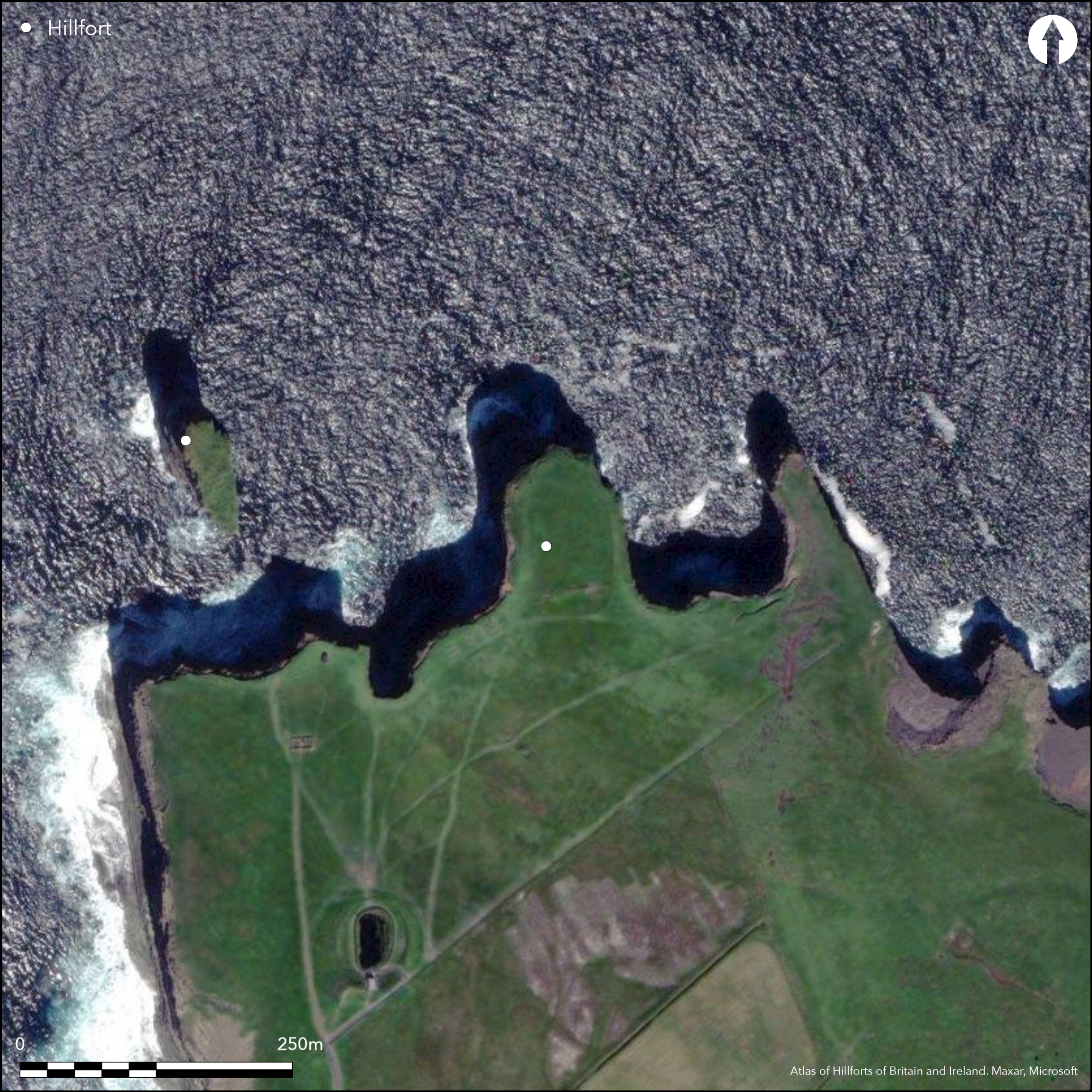
This promontory is situated at 'Downpatrick Head' c. 5.5km N of Ballycastle village, lying between Bunatrahir Bay and Killala Bay on the coast of Co. Mayo. Projecting boldly N from the coast not far from the village of Ballycastle, the overall peninsula forming Downpatrick Head is bisected by an eroded fault plane running nearly N and S, with collapsed openings in the roof annotated ÇPoulbegga' and ÇPoulnash_ntona' on the first edition OS six-inch map. N of the peninsula is a sea stack known as ÇDunbriste', defended by a wall (Atlas No.1634). An Early Medieval monastic site is also situated on the headland here, depicted on the early maps as 'St. Patrick's Church'. The promontory fort lies to the NE and was recorded by Westropp as the 'Cliff Fort'. Access from the rest of the peninsula to the S is barred by a wall running E and W across the neck over a distance of c. 68m. The wall is of dry masonry 1.5m thick and up to 2.4m high where best preserved, and Westropp records that it consists of large slabs resting on a low bank 13m thick, which was possibly an earlier earthwork 'which once surrounded the whole headland' (1912, 107) and can still be seen extending along the E margin. A sector of the wall near the E margin has been removed over a distance of 11.5m, but Westropp also records a narrow entrance c. 1.2m wide. There are no hut-sites noted within the enclosed area which measures 78m N-S by 48m E-W.
Citizen Science: ✗
Reliability of Data: Confirmed
Reliability of Interpretation: Confirmed
X: -1040320 Y: 7232394 (EPSG: 3857)
Longitude: -9.345357900818392 Latitude: 54.32733217708751 (EPSG:4326)
Country: Republic of Ireland
Current County or Unitary Authority: Mayo
Historic County: Mayo
Current Parish/Community/Council/Townland: Knockaun
None
| Extant | ✓ |
| Cropmark | ✗ |
| Likely Destroyed | ✗ |
None
| Woodland | ✗ |
| Commercial Forestry Plantation | ✗ |
| Parkland | ✗ |
| Pasture (Grazing) | ✓ |
| Arable | ✗ |
| Scrub/Bracken | ✗ |
| Bare Outcrop | ✗ |
| Heather/Moorland | ✓ |
| Heath | ✗ |
| Built-up | ✗ |
| Coastal Grassland | ✗ |
| Other | ✗ |
This promontory is situated at 'Downpatrick Head' c. 5.5km N of Ballycastle village and projects N between Bunatrahir Bay and Killala Bay on the coast of Co. Mayo. The defended promontory is situated to the N of the peninsula, recorded by Westropp as the 'Cliff Fort' and is cut off from the larger peninsula by a wall running in an E/W direction for c. 68m.
| Contour Fort | ✗ |
| Partial Contour Fort | ✗ |
| Promontory Fort | ✓ |
| Hillslope Fort | ✗ |
| Level Terrain Fort | ✗ |
| Marsh Fort | ✗ |
| Multiple Enclosure Fort | ✗ |
| Hilltop | ✗ |
| Coastal Promontory | ✓ |
| Inland Promontory | ✗ |
| Valley Bottom | ✗ |
| Knoll/Hillock/Outcrop | ✗ |
| Ridge | ✗ |
| Cliff/Plateau-edge/Scarp | ✗ |
| Hillslope | ✗ |
| Lowland | ✗ |
| Spur | ✗ |
Dominant Topographic Feature: N-facing promontory
| North | ✓ |
| Northeast | ✗ |
| East | ✗ |
| Southeast | ✗ |
| South | ✗ |
| Southwest | ✗ |
| West | ✗ |
| Northwest | ✗ |
| Level | ✗ |
Altitude: 38.0m
N/A
There is no dating available for the site
Reliability: D - None
| Pre 1200BC | ✗ |
| 1200BC - 800BC | ✗ |
| 800BC - 400BC | ✗ |
| 400BC - AD50 | ✗ |
| AD50 - AD400 | ✗ |
| AD400 - AD 800 | ✗ |
| Post AD800 | ✗ |
| Unknown | ✓ |
| Pre Hillfort: | None |
| Post Hillfort: | None |
The Annals of the Four Masters record the 'cutting of the rock of Duross promontory, in Tirawley, by the sea in 1393'. Defences recorded on the first edition OS six-inch map (1839). Described by Otway in the associated O.S letters as a 'grouted wall'. Later surveyed by Westropp in 1912 who afforded the headland and associated features greater descriptions, including the local legends attached to the headland (1912, 107)
| 1st Identified Written Reference (1393): | Annals of the four Masters (O'Donovan) |
| 1st Identified Map Depiction (1839): | OS six-inch maps |
| Earthwork Survey (1839): | O.S Letters |
| Earthwork Survey (1912): | Thomas J. Westropp |
There are no recorded internal features within the enclosed headland although features recorded outside on the main peninsula include a number of barrows and other features relating to the early church site.
A well is recorded on the peninsula
| None | ✓ |
| Spring | ✗ |
| Stream | ✗ |
| Pool | ✗ |
| Flush | ✗ |
| Well | ✗ |
| Other | ✗ |
None
| No Known Features | ✓ |
| Round Stone Structures | ✗ |
| Rectangular Stone Structures | ✗ |
| Curvilinear Platforms | ✗ |
| Other Roundhouse Evidence | ✗ |
| Pits | ✗ |
| Quarry Hollows | ✗ |
| Other | ✗ |
None
| No Known Excavation | ✓ |
| Pits | ✗ |
| Postholes | ✗ |
| Roundhouses | ✗ |
| Rectangular Structures | ✗ |
| Roads/Tracks | ✗ |
| Quarry Hollows | ✗ |
| Other | ✗ |
| Nothing Found | ✗ |
None
| No Known Geophysics | ✓ |
| Pits | ✗ |
| Roundhouses | ✗ |
| Rectangular Structures | ✗ |
| Roads/Tracks | ✗ |
| Quarry Hollows | ✗ |
| Other | ✗ |
| Nothing Found | ✗ |
None
| No Known Finds | ✓ |
| Pottery | ✗ |
| Metal | ✗ |
| Metalworking | ✗ |
| Human Bones | ✗ |
| Animal Bones | ✗ |
| Lithics | ✗ |
| Environmental | ✗ |
| Other | ✗ |
NO APPARENT FEATURES
| APs Not Checked | ✓ |
| None | ✗ |
| Roundhouses | ✗ |
| Rectangular Structures | ✗ |
| Pits | ✗ |
| Postholes | ✗ |
| Roads/Tracks | ✗ |
| Other | ✗ |
Westropp records a narrow entrance c. 1.2m wide through the wall and earthen bank to the S.
| 1: | None |
| 2: | None |
Guard Chambers: ✗
Chevaux de Frise: ✗
| 1. Simple Gap (South): | None |
The defences comprise a wall running E and W across the neck for c. 68m, measuring 1.5m in thickness and up to 2.4m in height. Westropp records that it consisted of large slabs resting on a low bank 13m thick, which was possibly an earlier earthwork 'which once surrounded the whole headland' (1912, 107).
| Area 1: | 0.36ha. |
| Total: | 0.36ha. |
Total Footprint Area: 0.49ha.
None
| ✗ | None |
| ✗ | Westropp notes that the earthen bank underlying the stone wall may have been earlier and once surrounded the whole headland. Indeed the bank is evident along the promontory to the E. |
| NE Quadrant: | 0 |
| SE Quadrant: | 1 |
| SW Quadrant: | 1 |
| NW Quadrant: | 0 |
| Total: | 1 |
| Partial Univallate | ✓ |
| Univallate | ✗ |
| Partial Bivallate | ✗ |
| Bivallate | ✗ |
| Partial Multivallate | ✗ |
| Multivallate | ✗ |
| Unknown | ✗ |
| Partial Univallate | ✗ |
| Univallate | ✗ |
| Partial Bivallate | ✗ |
| Bivallate | ✗ |
| Partial Multivallate | ✗ |
| Multivallate | ✗ |
Stone wall surmounting earthen bank
| None | ✗ |
| Earthen Bank | ✓ |
| Stone Wall | ✓ |
| Rubble | ✗ |
| Wall-walk | ✗ |
| Evidence of Timber | ✗ |
| Vitrification | ✗ |
| Other Burning | ✗ |
| Palisade | ✗ |
| Counter Scarp Bank | ✗ |
| Berm | ✗ |
| Unfinished | ✗ |
| Other | ✗ |
None
| None | ✗ |
| Earthen Bank | ✗ |
| Stone Wall | ✗ |
| Murus Duplex | ✗ |
| Timber-framed | ✗ |
| Timber-laced | ✗ |
| Vitrification | ✗ |
| Other Burning | ✗ |
| Palisade | ✗ |
| Counter Scarp Bank | ✗ |
| Berm | ✗ |
| Unfinished | ✗ |
| No Known Excavation | ✓ |
| Other | ✗ |
| ✗ | None |
| ✗ | None |
Number of Ditches: 0
| ✗ | None |
Westropp, T.J. 1912. The promontory forts and early remains of the coasts of County Mayo. Part 1- The north coast (Tirawley and Erris). The Journal of the Royal Society of Antiquaries of Ireland 42, 59-139.
Atlas of Hillforts:
Wikidata:
This work is licensed under CC BY-SA 4.0

 and should be cited as:
Lock, Gary and Ralston, Ian. 2024. Atlas of Hillforts of Britain and Ireland. Available at: https://hillforts.arch.ox.ac.uk
Document Version 1.1