Satellite Imagery
Satellite Imagery
HER: Archaeological Survey of Ireland SMR Database MA002-006 (None)
NMR: MA 002 (None)
SM: None
NGR: None
X: 467935 Y: 839050 (IRENET95)
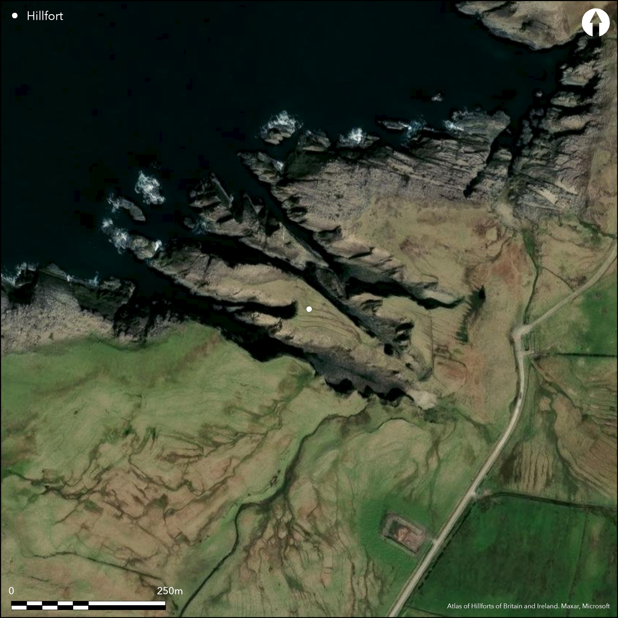
This coastal promontory is situated in the townland of Aghadoon S of the promontory at Spinkadoon (Atlas No.1668), Co. Mayo. Not marked on any edition of the OS six-inch maps, it was first noted by Dr. Charles Browne in 1894 as a possible early fort. Local folklore suggests that the fort was a favourite resting place of the swan children, and that Fiachra owned a famous 'sea-horse', mounted on which he could leap over the gully beside the fort (OS letters). Standing on a high headland with narrow gullies on either side, the narrow irregular promontory is connected to the mainland by a low neck that rises from a grassy basin. Access across the neck from the SE is blocked by two walls and a ditch. The outer of which is a nearly levelled wall 1.8m wide. Upslope 17.6m to the W is a second wall, 2.4m wide, partly reduced to a low bank faced with large blocks, but with its upper part in dry-stone work (Westropp 1912, 198). The ditch lies between the two walls and is 6.4m wide at the top and 3.6m at the bottom at a depth of 2.1m deep. The defences are pierced by a central a causeway 2.4m wide, beside which Westropp recorded a possible gate-lintel 1.5m long (1912, 198). The sloping entrance way leads up to the entrance through the inner wall. The wall itself is 11.5m long and its ends contract to 1.2m in thickness before turning back along the margins of the narrow promontory. The gateway lies towards the S end and is 0.9m wide, with parallel sides faced with large stones and rounded angles. The narrow grass-grown interior expands to a maximum breadth of 35m and gives way to bare rock after a distance of about 100m, 85m of the seaward end having been eroded by the sea. Westropp observed that the interior has been tilled, 'so no foundations or huts or enclosures remains' (1912, 198), and the traces of the rigs are plainly visible on satellite imagery.
Citizen Science: ✗
Reliability of Data: Confirmed
Reliability of Interpretation: Confirmed
X: -1116336 Y: 7223966 (EPSG: 3857)
Longitude: -10.02821499671695 Latitude: 54.283155361082166 (EPSG:4326)
Country: Republic of Ireland
Current County or Unitary Authority: Mayo
Historic County: Mayo
Current Parish/Community/Council/Townland: Aghadoon
None
| Extant | ✓ |
| Cropmark | ✗ |
| Likely Destroyed | ✗ |
None
| Woodland | ✗ |
| Commercial Forestry Plantation | ✗ |
| Parkland | ✗ |
| Pasture (Grazing) | ✓ |
| Arable | ✗ |
| Scrub/Bracken | ✗ |
| Bare Outcrop | ✗ |
| Heather/Moorland | ✓ |
| Heath | ✗ |
| Built-up | ✗ |
| Coastal Grassland | ✗ |
| Other | ✗ |
Standing on a high headland with narrow gullies on either side, the narrow irregular promontory is connected to the mainland by a low neck that rises from a grassy basin. It is defended to the SE by a number of works to the E.
| Contour Fort | ✗ |
| Partial Contour Fort | ✗ |
| Promontory Fort | ✓ |
| Hillslope Fort | ✗ |
| Level Terrain Fort | ✗ |
| Marsh Fort | ✗ |
| Multiple Enclosure Fort | ✗ |
| Hilltop | ✗ |
| Coastal Promontory | ✓ |
| Inland Promontory | ✗ |
| Valley Bottom | ✗ |
| Knoll/Hillock/Outcrop | ✗ |
| Ridge | ✗ |
| Cliff/Plateau-edge/Scarp | ✗ |
| Hillslope | ✗ |
| Lowland | ✗ |
| Spur | ✗ |
Dominant Topographic Feature: W-facing promontory
| North | ✗ |
| Northeast | ✗ |
| East | ✗ |
| Southeast | ✗ |
| South | ✗ |
| Southwest | ✗ |
| West | ✓ |
| Northwest | ✗ |
| Level | ✗ |
Altitude: 10.0m
N/A
There is no dating available for the site
Reliability: D - None
| Pre 1200BC | ✗ |
| 1200BC - 800BC | ✗ |
| 800BC - 400BC | ✗ |
| 400BC - AD50 | ✗ |
| AD50 - AD400 | ✗ |
| AD400 - AD 800 | ✗ |
| Post AD800 | ✗ |
| Unknown | ✓ |
| Pre Hillfort: | None |
| Post Hillfort: | None |
Not marked on any edition of the OS six-inch maps. First noted by Dr. Charles Browne in 1894 as a possible early fort. Visited and surveyed by Westropp in 1912.
| 1st Identified Written Reference (1894): | Charles Browne |
| Earthwork Survey (1912): | Thomas Westropp |
Apart from the cultivation rigs, there are no recorded internal features
Two streams are recorded on either side of the promontory
| None | ✓ |
| Spring | ✗ |
| Stream | ✗ |
| Pool | ✗ |
| Flush | ✗ |
| Well | ✗ |
| Other | ✗ |
None
| No Known Features | ✓ |
| Round Stone Structures | ✗ |
| Rectangular Stone Structures | ✗ |
| Curvilinear Platforms | ✗ |
| Other Roundhouse Evidence | ✗ |
| Pits | ✗ |
| Quarry Hollows | ✗ |
| Other | ✗ |
None
| No Known Excavation | ✓ |
| Pits | ✗ |
| Postholes | ✗ |
| Roundhouses | ✗ |
| Rectangular Structures | ✗ |
| Roads/Tracks | ✗ |
| Quarry Hollows | ✗ |
| Other | ✗ |
| Nothing Found | ✗ |
None
| No Known Geophysics | ✓ |
| Pits | ✗ |
| Roundhouses | ✗ |
| Rectangular Structures | ✗ |
| Roads/Tracks | ✗ |
| Quarry Hollows | ✗ |
| Other | ✗ |
| Nothing Found | ✗ |
None
| No Known Finds | ✓ |
| Pottery | ✗ |
| Metal | ✗ |
| Metalworking | ✗ |
| Human Bones | ✗ |
| Animal Bones | ✗ |
| Lithics | ✗ |
| Environmental | ✗ |
| Other | ✗ |
NO APPARENT FEATURES
| APs Not Checked | ✓ |
| None | ✗ |
| Roundhouses | ✗ |
| Rectangular Structures | ✗ |
| Pits | ✗ |
| Postholes | ✗ |
| Roads/Tracks | ✗ |
| Other | ✗ |
The defences are pierced by a central a causeway 2.4m wide, beside which Westropp recorded a possible gate-lintel 1.5m long (1912, 198). The sloping entrance way leads up to the entrance through the inner wall. The wall itself is 11.5m long and its ends contract to 1.2m in thickness before turning back along the margins of the narrow promontory. The gateway lies towards the S end and is 0.9m wide, with parallel sides faced with large stones and rounded angles.
| 1: | None |
| 2: | None |
Guard Chambers: ✗
Chevaux de Frise: ✗
| 1. Simple Gap (South east): | None |
Access across the neck from the SE is blocked by two walls and a ditch. The outer of which is a nearly levelled wall 1.8m wide. Upslope 17.6m to the W is a second wall, 2.4m wide, partly reduced to a low bank faced with large blocks, but with its upper part in dry-stone work (Westropp 1912, 198). The ditch lies between the two walls and is 6.4m wide at the top and 3.6m at the bottom at a depth of 2.1m deep. The inner wall is 11.5m long and the ends contract to 1.2m in thickness before turning back along the margins of the narrow headland.
| Area 1: | 0.41ha. |
| Total: | 0.41ha. |
Total Footprint Area: 0.43ha.
None
| ✗ | None |
| ✗ | None |
| NE Quadrant: | 0 |
| SE Quadrant: | 2 |
| SW Quadrant: | 0 |
| NW Quadrant: | 0 |
| Total: | 2 |
| Partial Univallate | ✗ |
| Univallate | ✗ |
| Partial Bivallate | ✓ |
| Bivallate | ✗ |
| Partial Multivallate | ✗ |
| Multivallate | ✗ |
| Unknown | ✗ |
| Partial Univallate | ✗ |
| Univallate | ✗ |
| Partial Bivallate | ✗ |
| Bivallate | ✗ |
| Partial Multivallate | ✗ |
| Multivallate | ✗ |
None
| None | ✗ |
| Earthen Bank | ✗ |
| Stone Wall | ✓ |
| Rubble | ✗ |
| Wall-walk | ✗ |
| Evidence of Timber | ✗ |
| Vitrification | ✗ |
| Other Burning | ✗ |
| Palisade | ✗ |
| Counter Scarp Bank | ✗ |
| Berm | ✗ |
| Unfinished | ✗ |
| Other | ✗ |
None
| None | ✗ |
| Earthen Bank | ✗ |
| Stone Wall | ✗ |
| Murus Duplex | ✗ |
| Timber-framed | ✗ |
| Timber-laced | ✗ |
| Vitrification | ✗ |
| Other Burning | ✗ |
| Palisade | ✗ |
| Counter Scarp Bank | ✗ |
| Berm | ✗ |
| Unfinished | ✗ |
| No Known Excavation | ✓ |
| Other | ✗ |
| ✗ | None |
| ✓ | None |
Number of Ditches: 1
| ✗ | None |
Browne, C. 1895. The ethnography of the Mullet, Inishkea Islands, and Portnacloy, Co. Mayo. Proceedings of the Royal Irish Academy 19 587- 637
O'Donovan, J. 1838. Ordnance Survey Letters, Co. Mayo
Otway, C. 1841. Sketches in Erris and Tirawley. Dublin
Pococke, R. 1752. Pococke's Tour of Ireland (ed. G. Stokes), Dublin 1891.
Westropp, T.J. 1912. The promontory forts and early remains of the coasts of County Mayo. Part 1- The north coast (Tirawley and Erris). The Journal of the Royal Society of Antiquaries of Ireland 42, 59-139.
Atlas of Hillforts:
Wikidata:
This work is licensed under CC BY-SA 4.0

 and should be cited as:
Lock, Gary and Ralston, Ian. 2024. Atlas of Hillforts of Britain and Ireland. Available at: https://hillforts.arch.ox.ac.uk
Document Version 1.1